It looks like you're using an Ad Blocker.
Please white-list or disable AboveTopSecret.com in your ad-blocking tool.
Thank you.
Some features of ATS will be disabled while you continue to use an ad-blocker.

Hurricane Lane - Now Cat 5 w/ Hawaii in its crosshairs
page: 4share:
a reply to: Phage
I'll try.
Actually I met the research team once in Glennallen while waiting on my wife who was in the same store. Nice bunch and unlike how they reacted to that angry self righteous Ventura they invited me to come for a tour anytime. Of course that was way back when they were still nuking everyone's brains, hitting China with earthquake rays and controlling the weather. I think they stopped that due to lack of funding, but I'll check
Here's hoping you and everyone else come out OK and unharmed.
a reply to: Blaine91555
Wind has been slow building. Only about 20kts here.
The strong stuff is going to wait until night time to take the power out. Running the last laundry load now.
Wind has been slow building. Only about 20kts here.
The strong stuff is going to wait until night time to take the power out. Running the last laundry load now.
edit on 8/24/2018 by Phage because: (no reason given)
a reply to: Cauliflower
They aren't, for the most part. The wind is the big threat to the grid. Trees and stuff.
They aren't, for the most part. The wind is the big threat to the grid. Trees and stuff.
edit on 8/24/2018 by Phage because: (no reason given)
I wonder how the storm surge will effect the islands.
I never heard of a hurricane there except on magnum p.i..
I never heard of a hurricane there except on magnum p.i..
a reply to: howtonhawky
Not as bad as with continental land masses.
But Lane is down to cat 2 now (forecast to be sub-hurricane in 24 hours), so surge won't be a big deal. The surf will be pretty large though.
Not as bad as with continental land masses.
But Lane is down to cat 2 now (forecast to be sub-hurricane in 24 hours), so surge won't be a big deal. The surf will be pretty large though.
edit on 8/24/2018 by Phage because: (no reason given)
edit on 8/24/2018 by Phage because: (no reason given)
a reply to: howtonhawky
Activity at both the summit and east flank of Kilauea has been very low for a few weeks now.
www.abovetopsecret.com...
Activity at both the summit and east flank of Kilauea has been very low for a few weeks now.
www.abovetopsecret.com...
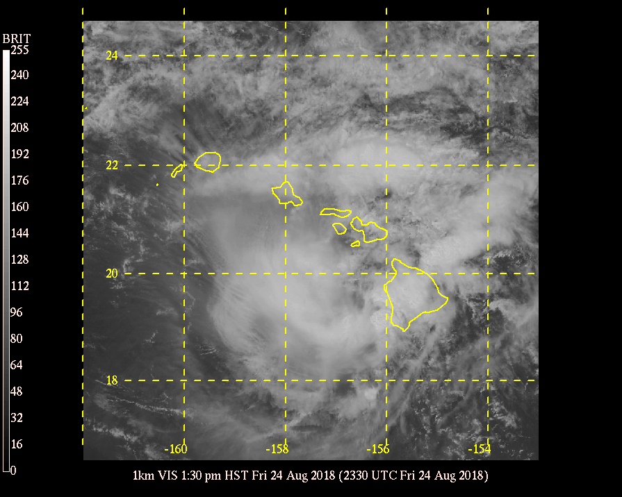
This is interesting. If it's what it looks like, the eye just collapsed entirely and suddenly.
weather.hawaii.edu...
I'll see if I can make a gif.
Hey Blaine! Thank your buddies for me.
weather.hawaii.edu...
I'll see if I can make a gif.
Hey Blaine! Thank your buddies for me.
I think I saw what I thought I saw.
The wind has been dropping a bit, and the satellite sure don't show what looks like a hurricane.
Eagerly awaiting the next update.
The wind has been dropping a bit, and the satellite sure don't show what looks like a hurricane.
Eagerly awaiting the next update.
edit on 8/24/2018 by Phage because: (no reason given)
Wind shear is your friend if hurricanes are not.
Hopefully the islands can deal with rain better than much of the US coast.
Hopefully the islands can deal with rain better than much of the US coast.
originally posted by: jhn7537
Hey everybody - I will keep this thread short and sweet. It looks like Hawaii could be at risk, with a developing/intensifying storm barely down at it... Lets hope it turns away. I have quite a few friends who live out in Maui & Oahu, and they mentioned how worried they were. Grocery stores have already ran out of supply's, and people are struggling to get off town (by flights).. Going to be a scary 36-48 hours as this storm makes its way near Hawaii.
Hurricane Lane strengthened to a Category 5 storm late Tuesday with maximum sustained winds of 160 mph as it moved closer to Hawaii, the National Hurricane Center said. Hawaii County, also known as the Big Island, is under a hurricane warning, meaning hurricane conditions are expected in the next 36 hours. Oahu and Maui County, which includes the islands of Maui, Lanai, Molokai and Kahoolawe, are under a hurricane watch. A Hurricane Watch means that hurricane conditions are possible within the next 48 hours. As of 1 a.m. ET, Lane was located about 375 miles south of Kailua-Kona, on the west coast of Big Island, and about 535 miles south of Honolulu. On the forecast track, the storm is expected to move very close to or over the main Hawaiian Islands from Thursday through Saturday.
CBS News
ABC News
The Weather Channel
I will add more info as it continues to develop along.
Hope all your friends stay safe, including the people who have been going through so much already. Now they are having a big forest fire as well...not sure if it's contained yet or not.
a reply to: roadgravel
A friend indeed. And a strong feature of this latitude. On the surface, prevailing northeast tradewinds. At 250mb, prevailing westerlies. One thing that makes hurricanes less than common in Hawaii.
Flash flooding is as dangerous here as anywhere. But it doesn't tend to stay around long.
The 1400 update doesn't say much except for degrading the storm again. Being cautious, as they should be.
www.prh.noaa.gov...
Feeling better.
A friend indeed. And a strong feature of this latitude. On the surface, prevailing northeast tradewinds. At 250mb, prevailing westerlies. One thing that makes hurricanes less than common in Hawaii.
Flash flooding is as dangerous here as anywhere. But it doesn't tend to stay around long.
The 1400 update doesn't say much except for degrading the storm again. Being cautious, as they should be.
This special advisory reduces the current intensity of Lane to 75
kt based on rapid weakening of the associated cloud and radar
patterns observed over the past few hours, and adjusts the intensity
and wind radii forecast to better agree with current trends. There
are no other changes at this time. This special advisory takes the
place of the 2 pm intermediate advisory.
www.prh.noaa.gov...
Feeling better.
edit on 8/24/2018 by Phage because: (no reason given)
a reply to: roadgravel
You'd be surprised where people build things.
"Meh, this stream hasn't run in years. Those boulders in the streambed, I don't know where they came from but it can't mean much."
A bit of an exaggeration. A bit. But I may be a bit giddy.
You'd be surprised where people build things.
"Meh, this stream hasn't run in years. Those boulders in the streambed, I don't know where they came from but it can't mean much."
A bit of an exaggeration. A bit. But I may be a bit giddy.
edit on 8/24/2018 by Phage because: (no reason given)
new topics
-
Who could it beeee now?
New World Order: 2 hours ago -
The Russian Vostok complex has been put into operation in Antarctica
Science & Technology: 2 hours ago -
Letitia James tells judge to Reject Trumps $175 Million Bond
2024 Elections: 2 hours ago -
Tucker Carlson UFOs are piloted by spiritual entities with bases under the ocean and the ground
Aliens and UFOs: 2 hours ago -
Hello from burritocat
Introductions: 4 hours ago -
An Apology From the Dunderbeck Sausage Company
Music: 6 hours ago -
Tucker on Joe Rogan talking Kona Blue and UFOs
Aliens and UFOs: 7 hours ago -
Remember These Attacks When President Trump 2.0 Retribution-Justice Commences.
2024 Elections: 8 hours ago -
Predicting The Future: The Satanic Temple v. Florida
Conspiracies in Religions: 8 hours ago -
WF Killer Patents & Secret Science Vol. 1 | Free Energy & Anti-Gravity Cover-Ups
General Conspiracies: 10 hours ago
top topics
-
Biden says little kids flip him the bird all the time.
Politicians & People: 17 hours ago, 9 flags -
Man sets himself on fire outside Donald Trump trial
Mainstream News: 17 hours ago, 9 flags -
Michigan school district cancels lesson on gender identity and pronouns after backlash
Education and Media: 12 hours ago, 9 flags -
WF Killer Patents & Secret Science Vol. 1 | Free Energy & Anti-Gravity Cover-Ups
General Conspiracies: 10 hours ago, 8 flags -
Pentagon acknowledges secret UFO project, the Kona Blue program | Vargas Reports
Aliens and UFOs: 15 hours ago, 7 flags -
Remember These Attacks When President Trump 2.0 Retribution-Justice Commences.
2024 Elections: 8 hours ago, 6 flags -
Boston Dynamics say Farewell to Atlas
Science & Technology: 15 hours ago, 6 flags -
Israel attacking Iran again.
Middle East Issues: 12 hours ago, 5 flags -
The Russian Vostok complex has been put into operation in Antarctica
Science & Technology: 2 hours ago, 4 flags -
Who could it beeee now?
New World Order: 2 hours ago, 3 flags
active topics
-
Judge Napolitano Talks Phone Call About JFK Assassination with POTUS Trump
Political Conspiracies • 24 • : StoutBroux -
Israel attacking Iran again.
Middle East Issues • 49 • : FlyersFan -
Hello from burritocat
Introductions • 5 • : leongrad -
"We're All Hamas" Heard at Columbia University Protests
Social Issues and Civil Unrest • 134 • : FlyersFan -
I Guess Cloud Seeding Works
Fragile Earth • 32 • : leongrad -
Candidate TRUMP Now Has Crazy Judge JUAN MERCHAN After Him - The Stormy Daniels Hush-Money Case.
Political Conspiracies • 413 • : Justoneman -
Who could it beeee now?
New World Order • 5 • : 19Bones79 -
Remember These Attacks When President Trump 2.0 Retribution-Justice Commences.
2024 Elections • 20 • : FlyersFan -
OUT OF THE BLUE Chilling moment pulsating blue cigar-shaped UFO is filmed hovering over PHX AZ
Aliens and UFOs • 44 • : ArMaP -
Russian intelligence officer: explosions at defense factories in the USA and Wales may be sabotage
Weaponry • 181 • : andy06shake