It looks like you're using an Ad Blocker.
Please white-list or disable AboveTopSecret.com in your ad-blocking tool.
Thank you.
Some features of ATS will be disabled while you continue to use an ad-blocker.

New images from an old spacecraft (Viking Orbiter)
page: 1share:
Over the past decades, NASA had sent dozens of spacecraft to study the Solar System and its planets, and you'd think we have seen everything there was
to be seen from those missions, including all the images. Occasionally, though, some of the original spacecraft data is brought up to light using
modern reprocessing techniques, to be seen for the first time in its full glory.
One guy came across an old (1978) book with Viking Orbiter images of Mars, many of which were black&white, grainy, and oversaturated. He then accessed the raw data archived by NASA, and started working on it to bring it into the digital age.
Viking Orbiter images from the 1970s and 1980s have been recently reprocessed to reveal their unique and beautiful perspectives on the planet: planetary.org...
These amazing new Mars images have been hidden in Viking orbiter data for 40 years.
Make sure to check out the article linked here for more images, descriptions, and links to full-sized images at Flickr. The full-sized version of Valles Marineris image is gorgeous.
One guy came across an old (1978) book with Viking Orbiter images of Mars, many of which were black&white, grainy, and oversaturated. He then accessed the raw data archived by NASA, and started working on it to bring it into the digital age.
Viking Orbiter images from the 1970s and 1980s have been recently reprocessed to reveal their unique and beautiful perspectives on the planet: planetary.org...
These amazing new Mars images have been hidden in Viking orbiter data for 40 years.
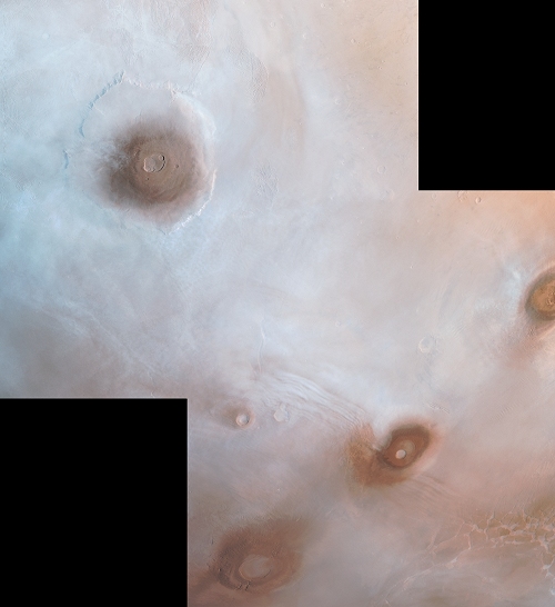
Viking Orbiter view of the northwestern Tharsis plateau, with the three Tharsis Montes at bottom left (from top to bottom: Ascraeus Mons, Pavonis Mons, and Arsia Mons) and Olympus Mons at top right. The mountains are shrouded in the aphelion cloud belt, a thin layer of water ice crystals that form over the Tharsis Plateau when Mars is furthest from the Sun.
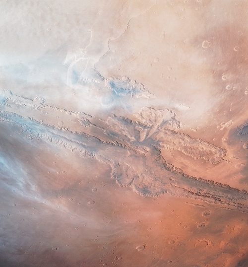
Color image of a cloudy afternoon over the Valles Marineris canyon system, taken by Viking Orbiter 1 during its 701st orbit of Mars, on September 29, 1979.
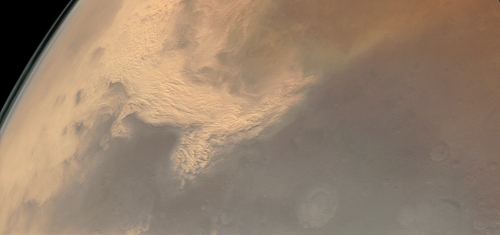
Viking image mosaic of the beginnings of the 1977 Mars global dust storm. In this mosaic, a regional dust storm is sweeping south off the Thaumasia Plateau.
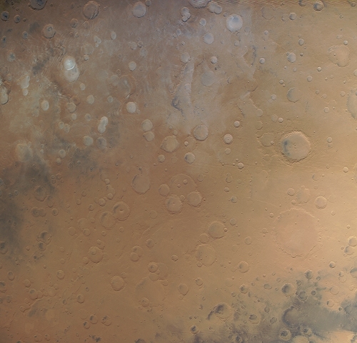
This image of Mars is a 4-frame color mosaic taken by Viking Orbiter 1. This mosaic covers some of the oldest terrain on the Martian surface, eastern Noachis Terra.
Make sure to check out the article linked here for more images, descriptions, and links to full-sized images at Flickr. The full-sized version of Valles Marineris image is gorgeous.
edit on 8-5-2018 by wildespace because:
(no reason given)
Wow ! Awesome pictures.....
Where's all the Flat earth tards to say "photoshop" ????
Where's all the Flat earth tards to say "photoshop" ????
originally posted by: Darklyilluminated
Wow ! Awesome pictures.....
Where's all the Flat earth tards to say "photoshop" ????
In the ultimate irony the flat earth people were asked by Elon musk where the flat mars society was at. The flat earth group responded by saying Mars is a sphere because science has proven it.
So in their mind just the Earth is flat. Everything else is round/sphere.
Cool pics op. Thanks for sharing.
Wow!
These images are precious
At work, but can't wait to blow em up on PC, thanks for sharing OP
These images are precious
At work, but can't wait to blow em up on PC, thanks for sharing OP
originally posted by: watchitburn
a reply to: Xcathdra
Makes perfect sense!
Because gravity holds the water from falling off the 90° walls
Uh yeah perfect sense!
a reply to: wildespace
Not gonna lie, was scrolling down slowly and the top of that first one made me go "nipple?" Great pictures though, love when this stuff shows up.
Not gonna lie, was scrolling down slowly and the top of that first one made me go "nipple?" Great pictures though, love when this stuff shows up.
originally posted by: watchitburn
a reply to: Xcathdra
Makes perfect sense!
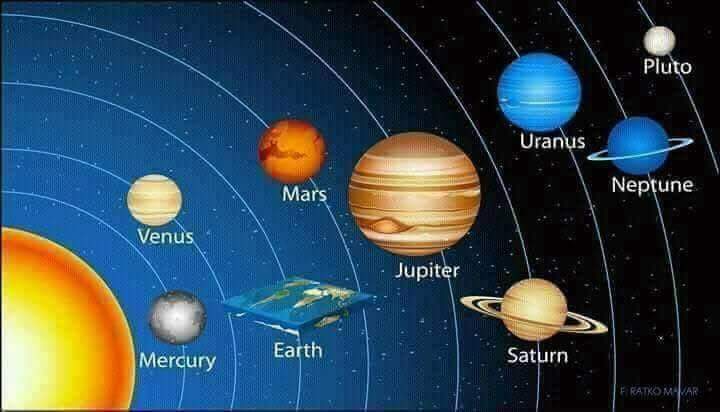
What inaccurate trash. How can ATS allow the posting of something so blatantly false, even in jest; Pluto isn’t a planet
Is it just me or does anyone else notice the 2nd photo from center up looks like dried up river tributaries that once filled a lake ?
I guess it "was just my imagination , running away with me"
I guess it "was just my imagination , running away with me"
originally posted by: eNumbra
What inaccurate trash. How can ATS allow the posting of something so blatantly false, even in jest; Pluto isn’t a planet
I am stubbornly one of those Pluto Is A Planet people.
I do enjoy arguing with my 8 yo about it. Good exercise for him in logic and reasoning.
frankly this is a bit odd, the resolution is too good for the time they were taken
originally posted by: humanoidlord
frankly this is a bit odd, the resolution is too good for the time they were taken
Most of those images are mosaics, consisting of multiple frames stitched together.
originally posted by: Gothmog
Is it just me or does anyone else notice the 2nd photo from center up looks like dried up river tributaries that once filled a lake ?
I guess it "was just my imagination , running away with me"
Valles Marineris is, indeed, thought to have been carved out by water. www.space.com...
To give you an idea as to the amount of work that went into it, here are the raw Viking images from NASA archive:
Link
Here's a couple of the images, for example:
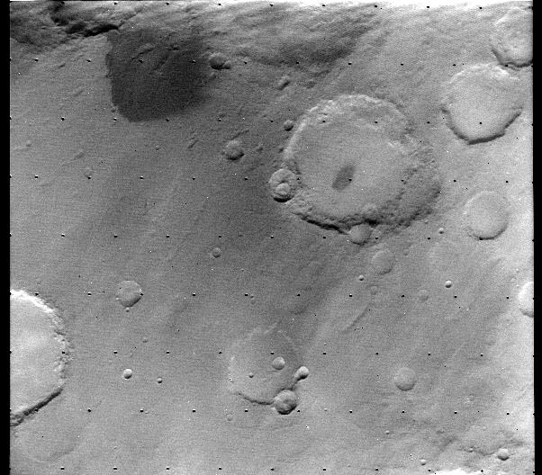

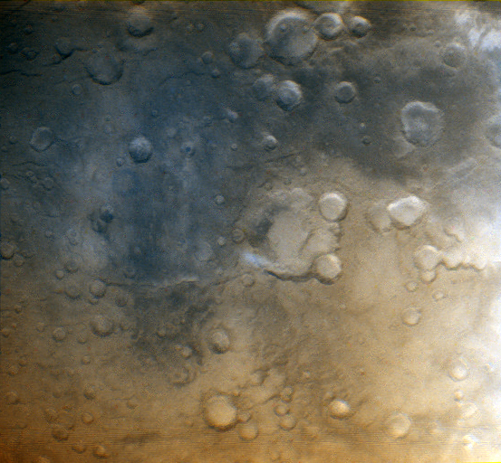
My attempt at making a colour image from this frame:
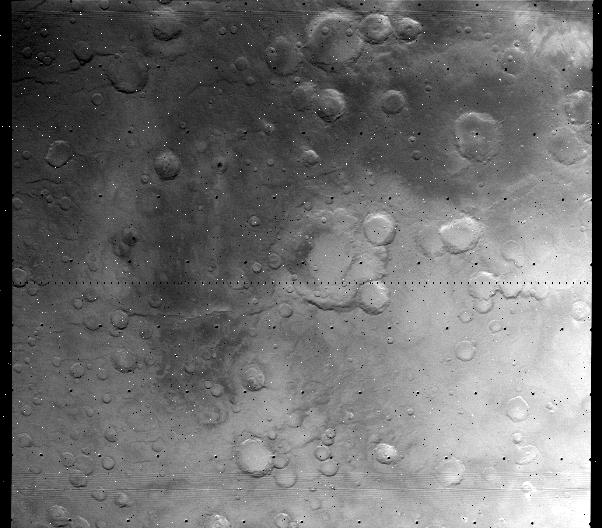
Only resulted in this, after realigning the frames, balancing the colours, and removing the dots:
Here's a couple of the images, for example:
My attempt at making a colour image from this frame:
Only resulted in this, after realigning the frames, balancing the colours, and removing the dots:
edit on 9-5-2018 by wildespace because: (no reason given)
I find it very interesting the dense cloud covered images as a lot of 70's - 80's of Mars narrative was a dead world without much of an atmosphere.
This stunner Deuteronilus Mensae or this one in
Tharsis Montes would have been a shocker in 1976, actually they are
very amazing and a bit shocking today...just sayin
new topics
-
Is the origin for the Eye of Horus the pineal gland?
General Conspiracies: 51 minutes ago -
Man sets himself on fire outside Donald Trump trial
Mainstream News: 1 hours ago -
Biden says little kids flip him the bird all the time.
2024 Elections: 1 hours ago -
The Democrats Take Control the House - Look what happened while you were sleeping
US Political Madness: 1 hours ago -
Sheetz facing racial discrimination lawsuit for considering criminal history in hiring
Social Issues and Civil Unrest: 1 hours ago -
In an Historic First, In N Out Burger Permanently Closes a Location
Mainstream News: 3 hours ago -
MH370 Again....
Disaster Conspiracies: 4 hours ago -
Are you ready for the return of Jesus Christ? Have you been cleansed by His blood?
Religion, Faith, And Theology: 6 hours ago -
Chronological time line of open source information
History: 7 hours ago -
A man of the people
Diseases and Pandemics: 9 hours ago
top topics
-
Israeli Missile Strikes in Iran, Explosions in Syria + Iraq
World War Three: 17 hours ago, 19 flags -
In an Historic First, In N Out Burger Permanently Closes a Location
Mainstream News: 3 hours ago, 14 flags -
The Democrats Take Control the House - Look what happened while you were sleeping
US Political Madness: 1 hours ago, 8 flags -
Thousands Of Young Ukrainian Men Trying To Flee The Country To Avoid Conscription And The War
Other Current Events: 14 hours ago, 7 flags -
Iran launches Retalliation Strike 4.18.24
World War Three: 17 hours ago, 6 flags -
12 jurors selected in Trump criminal trial
US Political Madness: 17 hours ago, 4 flags -
4 plans of US elites to defeat Russia
New World Order: 10 hours ago, 4 flags -
A man of the people
Diseases and Pandemics: 9 hours ago, 4 flags -
Man sets himself on fire outside Donald Trump trial
Mainstream News: 1 hours ago, 4 flags -
Biden says little kids flip him the bird all the time.
2024 Elections: 1 hours ago, 3 flags
active topics
-
Is the origin for the Eye of Horus the pineal gland?
General Conspiracies • 1 • : ARM19688 -
George Knapp AMA on DI
Area 51 and other Facilities • 25 • : TheValeyard -
Thousands Of Young Ukrainian Men Trying To Flee The Country To Avoid Conscription And The War
Other Current Events • 25 • : twistedpuppy -
Silent Moments --In Memory of Beloved Member TDDA
Short Stories • 46 • : Encia22 -
Man sets himself on fire outside Donald Trump trial
Mainstream News • 8 • : BernnieJGato -
12 jurors selected in Trump criminal trial
US Political Madness • 73 • : ImagoDei -
The Democrats Take Control the House - Look what happened while you were sleeping
US Political Madness • 15 • : matafuchs -
Are you ready for the return of Jesus Christ? Have you been cleansed by His blood?
Religion, Faith, And Theology • 17 • : TheValeyard -
Israeli Missile Strikes in Iran, Explosions in Syria + Iraq
World War Three • 100 • : Astrocometus -
Biden says little kids flip him the bird all the time.
2024 Elections • 5 • : TheValeyard