It looks like you're using an Ad Blocker.
Please white-list or disable AboveTopSecret.com in your ad-blocking tool.
Thank you.
Some features of ATS will be disabled while you continue to use an ad-blocker.

160 miles south of Louisiana in the gulf of Mexico major temp anomaly 108 to 133 degress F.
page: 2share:
As far as I can tell, there is nothing verifiable about this at all. That includes MamaBeth's link to All News Pipeline. The story is more about
theory than fact. I can't find a single reliable source that confirms the anomaly. I guess this could be a conspiracy by TPTB to cover it up and
only alternate news sites will report it. I just don't believe it.
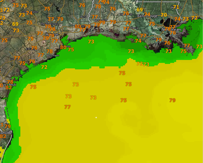
Checking Satellite images temperature maps of the gulf, doesn't show this anomaly.
You can see current ones here:
Gulf heat maps
You can see current ones here:
Gulf heat maps
a reply to: NoCorruptionAllowed
Not getting any fluctuations on NOAA either, but maybe I'm not looking in the right area.
www.ndbc.noaa.gov...
www.ndbc.noaa.gov...
Not getting any fluctuations on NOAA either, but maybe I'm not looking in the right area.
www.ndbc.noaa.gov...
www.ndbc.noaa.gov...
consider that the oil industry is busy squelching the news....
'they' don't want the world to know that their problem is because the Abiotic oil source in that particular region is being excessively heated in the depths of the Earth and the oil 'artery' is pooling the super heated Abiotic oil in those basins that are some 25,000 feet deep
'They are reluctant to Un-Plug an apparent 'clog' in the oil supply artery... so that the pooling oil can find it's way to oil fields closer to the surface among the normal drilling platforms that are 5k-10k feet down in the strata.
the 'excessively heated' oil supplies are only known to the deep-water drill sites & is being kept secreted by the industry which is horrified that even some of the 'over heated Anomaly' news has already been leaked to the public domain
the world wide super heating of the Earth Mantle is showing up as volcanic activity elsewhere but ther in the Gulf-of-Mexico there is a super hot-spot causing different activity of real concern
these conserns are all results from the cracks in the Earth deep crust caused by the Asteroid event that caused the dinosaur extinction some 65+ million years ago down there in the Gulf
re Bing:
see: www.dailygalaxy.com...
check out the image in the linked article which shows an 'escarpment' or wall of fused rock resulting from the impact... that is what I am talking about which is possibly blocking the Aboitic oil flowing from the deeper areas of the Earth Crust towards the surface in normal conditions of refilling the semi-drained oil fields closer to the surface.....
things are 'building up' all over the globe
'they' don't want the world to know that their problem is because the Abiotic oil source in that particular region is being excessively heated in the depths of the Earth and the oil 'artery' is pooling the super heated Abiotic oil in those basins that are some 25,000 feet deep
'They are reluctant to Un-Plug an apparent 'clog' in the oil supply artery... so that the pooling oil can find it's way to oil fields closer to the surface among the normal drilling platforms that are 5k-10k feet down in the strata.
the 'excessively heated' oil supplies are only known to the deep-water drill sites & is being kept secreted by the industry which is horrified that even some of the 'over heated Anomaly' news has already been leaked to the public domain
the world wide super heating of the Earth Mantle is showing up as volcanic activity elsewhere but ther in the Gulf-of-Mexico there is a super hot-spot causing different activity of real concern
these conserns are all results from the cracks in the Earth deep crust caused by the Asteroid event that caused the dinosaur extinction some 65+ million years ago down there in the Gulf
re Bing:
Chicxulub Crater is an ancient impact crater buried underneath the Yucatan peninsula, with its center located approximately underneath the town of Chicxulub, Yucatan, Mexico. Investigations suggest that this impact structure is dated from the late Cretaceous, about 65 million years ago.
see: www.dailygalaxy.com...
check out the image in the linked article which shows an 'escarpment' or wall of fused rock resulting from the impact... that is what I am talking about which is possibly blocking the Aboitic oil flowing from the deeper areas of the Earth Crust towards the surface in normal conditions of refilling the semi-drained oil fields closer to the surface.....
things are 'building up' all over the globe
edit on th31152138352718322018 by St Udio because: (no reason given)
edit on th31152138398018392018 by St Udio because: (no
reason given)
a reply to: intrptr
Not far from there:
"Deepwater Horizon oil spill of 2010, also called Gulf of Mexico oil spill of 2010, largest marine oil spill in history, caused by an April 20, 2010, explosion on the Deepwater Horizon oil rig—located in the Gulf of Mexico, approximately 41 miles (66 km) off the coast of Louisiana—and its subsequent sinking on April 22."
www.britannica.com...
www.nytimes.com...
originally posted by: IgnoranceIsntBlisss
I'm a gonna go with funky sensor / signal, such a substantial difference.
That is just the NASA sensor to measure Global Warming. It is a a floating sensor, painted black, with reflecting mirrors pointed it.
originally posted by: SeaYote
a reply to: intrptr
Not far from there:
"Deepwater Horizon oil spill of 2010, also called Gulf of Mexico oil spill of 2010, largest marine oil spill in history, caused by an April 20, 2010, explosion on the Deepwater Horizon oil rig—located in the Gulf of Mexico, approximately 41 miles (66 km) off the coast of Louisiana—and its subsequent sinking on April 22."
www.britannica.com...
www.nytimes.com...
Thanks. This are the coordinates where the rig burned down. The spilled oil settled who knows where, covering the bottom for miles. A giant black heat sink, absorbing the suns radiation.
On clear days when atmospheric and oceanic visibility is good and the sun is right over head will be the test.
Someone somewhere is collecting that data. They won't tell us though.
If major storms are made more severe by the heat from the ocean because of it, the news will blame global warming, tectonics, or vulcanism.
edit on 18-3-2018 by intrptr because: additional
Hmmm. Strange. It appears that something is going on. There could be a thermal vent involved or it could be a bad sensor. It could also be there
is some sort of hydrocarbon leaking that is pooling there and increasing the water temp at the surface.
It could be a lot of things, but the cause should be investigated to find out what is causing this anomaly.
It could be a lot of things, but the cause should be investigated to find out what is causing this anomaly.
While it's probably a sensor, I did check to see if there was any earthquake activity in the area, and there was: a 4.3 on 2/26
earthquake.usgs.gov...
I'm in Galveston so maybe I should keep my eyes open. lol
I'm in Galveston so maybe I should keep my eyes open. lol
I'll go wit bad sensor it's pretty deep for oil to be a heat sink. Pretty dark at nearly a mile down.
originally posted by: IgnoranceIsntBlisss
I'm a gonna go with funky sensor / signal, such a substantial difference.
That is my thought too. How do they determine the temperature of the water in so many locations? Maybe they have bouys?
originally posted by: Salander
originally posted by: IgnoranceIsntBlisss
I'm a go with funky sensor / signal, such a substantial difference.
That is my thought too. How do they determine the temperature of the water in so many locations? Maybe they have bouys?
Most readings are dome by satellite, primarily the Moderate Resolution Imaging Spectroradiometer (MODIS) onboard NASA’s Terra and Aqua satellites. They measure heat radiation in the infrared and microwave bands. Also, surface drifters from the Global Drifter Program (GDP) provide regularly about 60,000 night time SST measurements per month. There are also floating sensors, but these are used mainly to validate the satellite readings.
a reply to: 727Sky
I grew up on the west coast of Florida on the gulf coast , lots of weird things out there. Just a few years ago there was a 6.1 Earthquake that originated from almost the center of the gulf, my daughter felt it in Tampa. There is quite an underground cave system in central Florida, I remember some of the shrimpers used to swear there was a spot off of Hudson, miles offshore where if you were out there at night you could hear people talking, the thinking was that somehow the sound channeled through the caverns, some of which opened up on the gulf bottom. I always thought it was more likely what they were smoking in their pipes at night, but you never know. I did seem to read somewhere that there are supposedly mud volcanoes roughly in the area described, maybe there is warm water upwelling. Or maybe we are going to see a volcano come up out of the gulf (is that even possible?).
I grew up on the west coast of Florida on the gulf coast , lots of weird things out there. Just a few years ago there was a 6.1 Earthquake that originated from almost the center of the gulf, my daughter felt it in Tampa. There is quite an underground cave system in central Florida, I remember some of the shrimpers used to swear there was a spot off of Hudson, miles offshore where if you were out there at night you could hear people talking, the thinking was that somehow the sound channeled through the caverns, some of which opened up on the gulf bottom. I always thought it was more likely what they were smoking in their pipes at night, but you never know. I did seem to read somewhere that there are supposedly mud volcanoes roughly in the area described, maybe there is warm water upwelling. Or maybe we are going to see a volcano come up out of the gulf (is that even possible?).
edit on 18-3-2018 by openminded2011 because: (no reason given)
originally posted by: Salander
originally posted by: IgnoranceIsntBlisss
I'm a gonna go with funky sensor / signal, such a substantial difference.
That is my thought too. How do they determine the temperature of the water in so many locations? Maybe they have bouys?
Weather satellites. Those acquire data from the ocean surface like wave height, wave direction, temperature, wind direction, lightning strikes, humidity, danger of tornados, cloud coverage and all sorts of other data.
a reply to: stormcell
Hopefully an anomaly - otherwise that would be a solid "WTF" in the region. Nowhere near boiling for salt water at sea level, but lots of things would have died at that temp. If it was some kind of real event at surface temp, we could end up with a large amount of dead sea life - especially plankton - washing up on gulf shores.
Hopefully an anomaly - otherwise that would be a solid "WTF" in the region. Nowhere near boiling for salt water at sea level, but lots of things would have died at that temp. If it was some kind of real event at surface temp, we could end up with a large amount of dead sea life - especially plankton - washing up on gulf shores.
edit on 18-3-2018 by OrdoAdChao because: too many commas
I'm not sure that is possible, maybe in very shallow water, I would guess a malfunction.
I used to fish in those waters. 200 ft depth usually...sandy bottom...extensive oil drilling. I'm guessing an open deep well poiring out hot water,
mus, natural gas under pressure, thus the temps. That stuff comes out of the deep HOT.
originally posted by: OrdoAdChao
a reply to: stormcell
Hopefully an anomaly - otherwise that would be a solid "WTF" in the region. Nowhere near boiling for salt water at sea level, but lots of things would have died at that temp. If it was some kind of real event at surface temp, we could end up with a large amount of dead sea life - especially plankton - washing up on gulf shores.
That oil rig drilled one of the deepest wells in history. Definitely deep enough to form a geothermal well.
originally posted by: paraphi
For the rest of the world to whom Celsius is more understandable... I believe this is 39 - 56 degrees Celsius. 0 degrees Celsius is the freezing point, and 100 degrees is the boiling point of water. What could be easier?
Thermal vents seems the most logical explanation, or some other type of geological activity, although vents run along the lines of the tectonic plates, so it would be unusual. That or a glitch in the monitoring, or software.
It might have to do with manufacture, and I would venture to guess it's always been that. USA used to be the largest producer of automobiles for a long time, for example. There are airplanes and jets, a vast military, etc... all these things and the machinery to build them, to build our infrastructure, bridges and so on have been built on the imperial system.
Would it be amazing for the USA to finally join the metric system? Heck yeah it would! But in the process it would bankrupt our already bankrupt country and so it will not be done until the country suffers a collapse anyway.
new topics
-
Iran launches Retalliation Strike 4/18/24
World War Three: 5 minutes ago -
Israeli Missile Strikes in Iran, Explosions in Syria + Iraq
World War Three: 36 minutes ago -
George Knapp AMA on DI
Area 51 and other Facilities: 6 hours ago -
Not Aliens but a Nazi Occult Inspired and then Science Rendered Design.
Aliens and UFOs: 6 hours ago -
Louisiana Lawmakers Seek to Limit Public Access to Government Records
Political Issues: 8 hours ago -
The Tories may be wiped out after the Election - Serves them Right
Regional Politics: 9 hours ago -
So I saw about 30 UFOs in formation last night.
Aliens and UFOs: 11 hours ago
top topics
-
BREAKING: O’Keefe Media Uncovers who is really running the White House
US Political Madness: 13 hours ago, 25 flags -
George Knapp AMA on DI
Area 51 and other Facilities: 6 hours ago, 19 flags -
Biden--My Uncle Was Eaten By Cannibals
US Political Madness: 14 hours ago, 18 flags -
"We're All Hamas" Heard at Columbia University Protests
Social Issues and Civil Unrest: 14 hours ago, 7 flags -
Louisiana Lawmakers Seek to Limit Public Access to Government Records
Political Issues: 8 hours ago, 7 flags -
Israeli Missile Strikes in Iran, Explosions in Syria + Iraq
World War Three: 36 minutes ago, 5 flags -
So I saw about 30 UFOs in formation last night.
Aliens and UFOs: 11 hours ago, 5 flags -
Do we live in a simulation similar to The Matrix 1999?
ATS Skunk Works: 12 hours ago, 3 flags -
Not Aliens but a Nazi Occult Inspired and then Science Rendered Design.
Aliens and UFOs: 6 hours ago, 3 flags -
The Tories may be wiped out after the Election - Serves them Right
Regional Politics: 9 hours ago, 3 flags
active topics
-
Israeli Missile Strikes in Iran, Explosions in Syria + Iraq
World War Three • 10 • : WeMustCare -
British TV Presenter Refuses To Use Guest's Preferred Pronouns
Education and Media • 62 • : fringeofthefringe -
Iran launches Retalliation Strike 4/18/24
World War Three • 0 • : JimmyNeutr0n -
So I saw about 30 UFOs in formation last night.
Aliens and UFOs • 21 • : BrotherKinsMan -
President BIDEN Warned IRAN Not to Attack ISRAEL - Iran Responded with a Military Attack on Israel.
World War Three • 42 • : WeMustCare -
MULTIPLE SKYMASTER MESSAGES GOING OUT
World War Three • 36 • : Irishhaf -
Candidate TRUMP Now Has Crazy Judge JUAN MERCHAN After Him - The Stormy Daniels Hush-Money Case.
Political Conspiracies • 386 • : WeMustCare -
-@TH3WH17ERABB17- -Q- ---TIME TO SHOW THE WORLD--- -Part- --44--
Dissecting Disinformation • 535 • : cherokeetroy -
African "Newcomers" Tell NYC They Don't Like the Free Food or Shelter They've Been Given
Social Issues and Civil Unrest • 15 • : marg6043 -
Alabama Man Detonated Explosive Device Outside of the State Attorney General’s Office
Social Issues and Civil Unrest • 58 • : Unknownparadox