It looks like you're using an Ad Blocker.
Please white-list or disable AboveTopSecret.com in your ad-blocking tool.
Thank you.
Some features of ATS will be disabled while you continue to use an ad-blocker.

The Brigg Stones
page: 111
share:
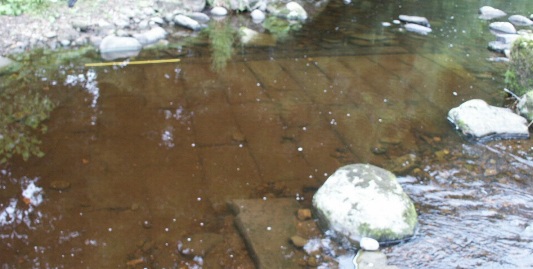
The Brigg Stones are the remains of a Roman weir that made the River Wear navigable at any tide as far as Chester-le-Street. The huge effort suggests
further work upstream to Durham was likely. I've examined the remains of weirs, towpaths, river narrowing, fish holding ponds and evidence of a
modular lock in Kepier Gorge, a short distance downstream from Durham. I thought they were Norman remains.
The Normans held prisoners in Kepier Gorge and forced them to quarry stone for Durham Cathedral. The stone was brought upstream to the cathedral by boat.
Now I wonder if the Normans took advantage of Roman river engineering. It appears the river may have been navigable from the sea to Durham and beyond almost two thousand years ago.
Kepier means Kep Weir, a weir with fish traps. Flint tools found in the vicinity of the gorge suggest fish were harvested here 10,000 years ago, most likely using fish weirs made from stones rolled down into the river, and basketwork traps. There is a very long history of river engineering here.
In the 1700's there were attempts to organise a scheme to make the river navigable from Durham to the sea. It was considered feasible, but expensive, to bring 20 ton vessels as far as Durham.
The flood of 1771 destroyed almost all man-made structures in or on the banks of the Wear.
Links to the ongoing investigation into the Brigg Stones.
www.sunderlands-forgotten-stones.com...
www.facebook.com...
www.sunderlandecho.com...
A possible Roman name for the Brigg Stones weir.
www.romaneranames.uk...
Raymond Selkirk's work.
www.romaneranames.uk...
A poem mentioning weirs and fish.
Some music by Godric of Finchale. Finchale is a short distance downstream from Kepier. Godric worked with Bishop Flambard in a good cop/bad cop routine. Stories about his life suggest he used his technical knowledge to make work easier for the captives quarrying the stone for the cathedral.
One of his tricks or 'miracles' was to produce fresh salmon for his guests when the salmon weren't running. It makes sense that his famous fishery would be upstream in Kepier Gorge. I know of two possible fish holding pools beside weirs in Kepier Gorge where migrating salmon could be trapped with a weighted hurdle across the entrance. The stories about Godric suggest he had a secret tunnel. He could sneak out and collect a fish, put it in one of his basketwork traps near Finchale, then send out a servant to find the fish caught 'miraculously' when no salmon were running. Guests suitably impressed.
The story of the Scottish prisoners held in Durham Cathedral has been suppressed until recently. The story of the captives used to quarry stone for the cathedral has yet to break in a big way.
The history of inland navigation on our rivers is not widely known. Study of the Brigg Stones will help bring awareness.
www.riveraccessforall.co.uk...
Opponents of recognition of public rights of navigation in all rivers claim that there were historic limitations on navigation. In particular, they claim that navigation was limited to the tidal sections . . .
We present the evidence for a public right of navigation.
There are estimated to be 42,700 miles of river in the U.K. but only 1,400 have a clear and undisputed right of public access.
There is a great deal of evidence of such a right throughout our recorded history, from Roman Law to Saxon Charters, to Magna Carta, to the work of the Commissioners for Sewers who were charged with removal of obstructions to navigation, to the absence of the need to create specific rights of navigation within the Acts of Parliament creating statutory river navigations. The public right of navigation on all rivers capable of navigation was completely unquestioned for 1800 years.
www.riveraccessforall.co.uk...
edit on 1 11 2017 by Kester because: (no reason given)
THere's a Roman ford across a river just a few miles from me, which is still there today. Pretty broken down, but when the river is low you can see
it. Amazing engineering.
a reply to: Painterz
I've crossed a small ford in Teesdale several times recently. I was amazed by how well built it is in spite of being on a little-used single track lane. Now I've seen photographs of the ford at Barnard Castle I realise the small ford may be Roman on a route that was important to them.
brigantesnation.com...
Sure thing, I'll try and take pictures.
It's Comrie, Perthshire, scotland. There's a tiny little Roman marching camp on one side of the river (where some lucky blighter found a perfect little gold roman coin just sitting once in the middle of a path) and a ford crossing leading into the wild untamed frontier lands.
This is about as far North-west as the Romans got. (They got further north up Aberdeen way, but this was one of their penetrations into the foothills of the highlands.)
Ardoch roman fort is nearby too, it's a much more substantial Roman site.
If all goods coming downriver from mineral rich Weardale had to be unloaded from river craft and transferred to sea-going vessels at the Brigg Stones
weir that would make it an ideal customs post. A good reason for it to be a complete barrier which is what the historical accounts suggest.
new topics
-
Massachusetts Drag Queen Leads Young Kids in Free Palestine Chant
Social Issues and Civil Unrest: 6 minutes ago -
Weinstein's conviction overturned
Mainstream News: 1 hours ago -
Supreme Court Oral Arguments 4.25.2024 - Are PRESIDENTS IMMUNE From Later Being Prosecuted.
Above Politics: 2 hours ago -
Krystalnacht on today's most elite Universities?
Social Issues and Civil Unrest: 3 hours ago -
Chris Christie Wishes Death Upon Trump and Ramaswamy
Politicians & People: 3 hours ago -
University of Texas Instantly Shuts Down Anti Israel Protests
Education and Media: 5 hours ago -
Any one suspicious of fever promotions events, major investor Goldman Sachs card only.
The Gray Area: 7 hours ago
top topics
-
VP's Secret Service agent brawls with other agents at Andrews
Mainstream News: 16 hours ago, 11 flags -
Krystalnacht on today's most elite Universities?
Social Issues and Civil Unrest: 3 hours ago, 7 flags -
Nearly 70% Of Americans Want Talks To End War In Ukraine
Political Issues: 17 hours ago, 6 flags -
Sunak spinning the sickness figures
Other Current Events: 17 hours ago, 5 flags -
Electrical tricks for saving money
Education and Media: 15 hours ago, 5 flags -
Weinstein's conviction overturned
Mainstream News: 1 hours ago, 5 flags -
Supreme Court Oral Arguments 4.25.2024 - Are PRESIDENTS IMMUNE From Later Being Prosecuted.
Above Politics: 2 hours ago, 5 flags -
University of Texas Instantly Shuts Down Anti Israel Protests
Education and Media: 5 hours ago, 3 flags -
Any one suspicious of fever promotions events, major investor Goldman Sachs card only.
The Gray Area: 7 hours ago, 2 flags -
Chris Christie Wishes Death Upon Trump and Ramaswamy
Politicians & People: 3 hours ago, 1 flags
active topics
-
Candidate TRUMP Now Has Crazy Judge JUAN MERCHAN After Him - The Stormy Daniels Hush-Money Case.
Political Conspiracies • 751 • : Oldcarpy2 -
University of Texas Instantly Shuts Down Anti Israel Protests
Education and Media • 111 • : cherokeetroy -
VP's Secret Service agent brawls with other agents at Andrews
Mainstream News • 47 • : ByeByeAmericanPie -
"We're All Hamas" Heard at Columbia University Protests
Social Issues and Civil Unrest • 284 • : 5thHead -
Supreme Court Oral Arguments 4.25.2024 - Are PRESIDENTS IMMUNE From Later Being Prosecuted.
Above Politics • 41 • : xuenchen -
Chris Christie Wishes Death Upon Trump and Ramaswamy
Politicians & People • 14 • : underpass61 -
-@TH3WH17ERABB17- -Q- ---TIME TO SHOW THE WORLD--- -Part- --44--
Dissecting Disinformation • 672 • : Thoughtful3 -
Massachusetts Drag Queen Leads Young Kids in Free Palestine Chant
Social Issues and Civil Unrest • 0 • : FlyersFan -
British TV Presenter Refuses To Use Guest's Preferred Pronouns
Education and Media • 160 • : WakeUpBeer -
God's Righteousness is Greater than Our Wrath
Religion, Faith, And Theology • 26 • : CristianVictoria
11