It looks like you're using an Ad Blocker.
Please white-list or disable AboveTopSecret.com in your ad-blocking tool.
Thank you.
Some features of ATS will be disabled while you continue to use an ad-blocker.

Potentially another hurricane forming in the Gulf of Mexico
page: 1share:
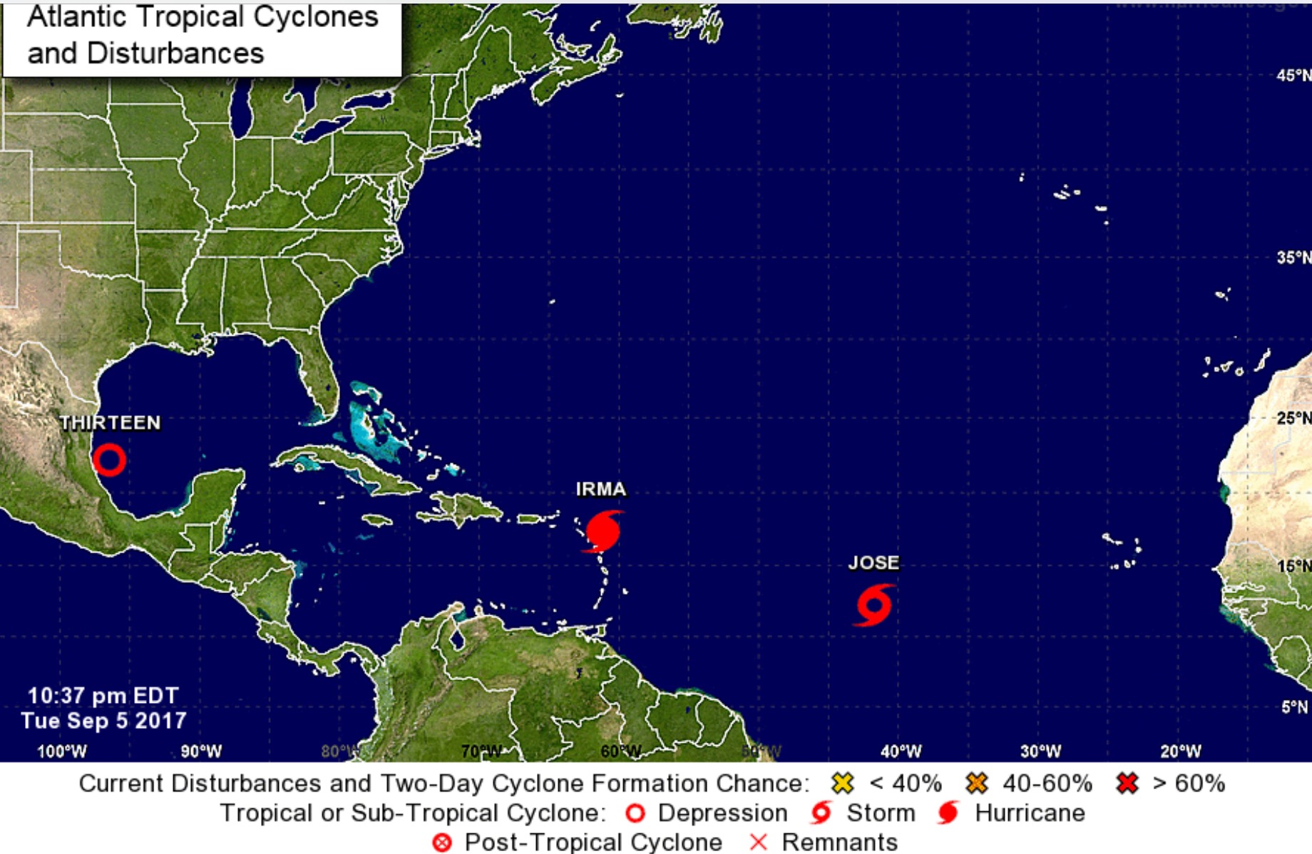
Tropical Depression Thirteen formed today in the gulf and the National hurricane Center has just updated this one to possibly become a hurricane
This is number 4 , if you include Harvey. Tropical Storm Jose (poised to become a hurricane by Wednesday) is lurking right behind Hurricane Irma in the Atlantic
Here's the info for now :
It will be named Katia ( I think) once its turns into a tropical storm
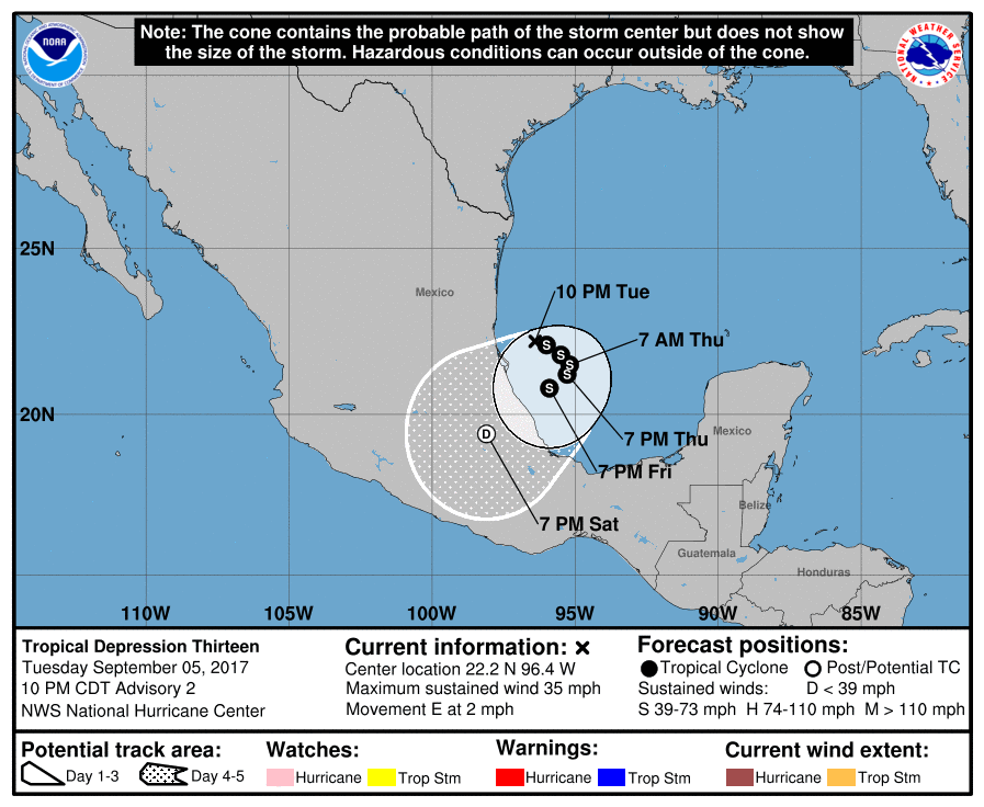
From NHC
TROPICAL DEPRESSION THIRTEEN
BULLETIN
Tropical Depression Thirteen Advisory Number 2
NWS National Hurricane Center Miami FL AL132017
1000 PM CDT Tue Sep 05 2017
...DEPRESSION DRIFTING EASTWARD IN THE SOUTHWESTERN GULF OF
MEXICO, COULD BECOME A HURRICANE IN A COUPLE OF DAYS...
SUMMARY OF 1000 PM CDT...0300 UTC...INFORMATION
-----------------------------------------------
LOCATION...22.2N 96.4W
ABOUT 95 MI...155 KM E OF TAMPICO MEXICO
MAXIMUM SUSTAINED WINDS...35 MPH...55 KM/H
PRESENT MOVEMENT...E OR 100 DEGREES AT 2 MPH...4 KM/H
MINIMUM CENTRAL PRESSURE...1008 MB...29.77 INCHES
NHC
This is number 4 , if you include Harvey. Tropical Storm Jose (poised to become a hurricane by Wednesday) is lurking right behind Hurricane Irma in the Atlantic
Here's the info for now :
It will be named Katia ( I think) once its turns into a tropical storm
From NHC
TROPICAL DEPRESSION THIRTEEN
BULLETIN
Tropical Depression Thirteen Advisory Number 2
NWS National Hurricane Center Miami FL AL132017
1000 PM CDT Tue Sep 05 2017
...DEPRESSION DRIFTING EASTWARD IN THE SOUTHWESTERN GULF OF
MEXICO, COULD BECOME A HURRICANE IN A COUPLE OF DAYS...
SUMMARY OF 1000 PM CDT...0300 UTC...INFORMATION
-----------------------------------------------
LOCATION...22.2N 96.4W
ABOUT 95 MI...155 KM E OF TAMPICO MEXICO
MAXIMUM SUSTAINED WINDS...35 MPH...55 KM/H
PRESENT MOVEMENT...E OR 100 DEGREES AT 2 MPH...4 KM/H
MINIMUM CENTRAL PRESSURE...1008 MB...29.77 INCHES
NHC
edit on 5-9-2017 by violet because: (no reason given)
edit on 5-9-2017 by violet because: (no reason
given)
edit on 5-9-2017 by violet because: (no reason given)
edit on 5-9-2017 by violet because: (no reason
given)
edit on 5-9-2017 by violet because: (no reason given)
edit on 5-9-2017 by violet because: (no reason
given)
edit on 5-9-2017 by violet because: (no reason given)
originally posted by: rickymouse
Sure seems like we are getting hammered this year.
True, but my liquor store has some phenomenal deals.
This one looks like it might affect eastern Mexico with heavy rains, but being in the warm water in th.gulf things can change.
There's some discussion going on that it may join forces with Irma and/or Jose
There's some discussion going on that it may join forces with Irma and/or Jose
It's funny how we are so much more advanced yet annual hurricanes kick our ass...
originally posted by: ConscienceZombie
It's funny how we are so much more advanced yet annual hurricanes kick our ass...
It may be that it is because we are so advanced that we are getting hammered more. We have warmed the climate so much that the sea surface heat content right now where Irma is has risen to an incredible 80 kilojoules per square centimeter. Heat is what dries the intensity of tropical cyclones. That computes to almost a megajoule per square foot. That translates to about the energy of 2 pounds of TNT for every 4 square feet of hurricane. The hurricane now has a 300 mile diameter for an area of about 71,000 square miles. Thats2x10^12 square feet. That means that the sea surface heat energy under Irma is equialent to 500 megatons of TNT. That's 33 Hiroshima bombs.
originally posted by: F4guy
originally posted by: ConscienceZombie
It's funny how we are so much more advanced yet annual hurricanes kick our ass...
It may be that it is because we are so advanced that we are getting hammered more. We have warmed the climate so much that the sea surface heat content right now where Irma is has risen to an incredible 80 kilojoules per square centimeter. Heat is what dries the intensity of tropical cyclones. That computes to almost a megajoule per square foot. That translates to about the energy of 2 pounds of TNT for every 4 square feet of hurricane. The hurricane now has a 300 mile diameter for an area of about 71,000 square miles. Thats2x10^12 square feet. That means that the sea surface heat energy under Irma is equialent to 500 megatons of TNT. That's 33 Hiroshima bombs.
Yep , you basic hurricane .
Doesnt care for sh** what man does , though.
a reply to: rickymouse
That last one is going to Mexico according to the cone of probability. Although they say it's moving eastward right now. I guess they expect it to circle around.
That last one is going to Mexico according to the cone of probability. Although they say it's moving eastward right now. I guess they expect it to circle around.
a reply to: violet
Storms don't usually merge. One system moves another but they don't combine. Not as a regular occurrence anyway.
The perfect storm for which that movie was named combined a Canadian maritime storm and a hurricane.
Super storm Sandy did the same thing. But that's a rare occurrence.
Storms don't usually merge. One system moves another but they don't combine. Not as a regular occurrence anyway.
The perfect storm for which that movie was named combined a Canadian maritime storm and a hurricane.
Super storm Sandy did the same thing. But that's a rare occurrence.
a reply to: F4guy
Hurricanes require rising air from converging winds, heat and moisture to form. A 0.01° degree rise in the ocean isn't going to have any effect on that. We haven't warmed the climate, it's doing what it is designed to do and has done for billions of years.
Hurricanes require rising air from converging winds, heat and moisture to form. A 0.01° degree rise in the ocean isn't going to have any effect on that. We haven't warmed the climate, it's doing what it is designed to do and has done for billions of years.
Well, this is what we get for having the last few years off of major destructive hurricanes..... Mother nature playing a little game of "catch-up"
violet:
Indeed. Ideally (in terms of 'lesser of two evils'), you want Katia to move North-eastwards out into the Gulf sea and offer some token resistance to Irma from entering the Gulf. The problem is the direction of circular motion of both Katia and Irma. Katia is clockwise and Irma is counter-clockwise, so the potential for merging is there. Irma could steal the heat from Katia and regain strength, and drive Katia either out-of-business entirely, or nudge Katia south-eastwards.
I have this feeling that Irma will enter the Gulf, regain strength and hit New Orleans as a cat 4? I hope I am wrong.
There's some discussion going on that it may join forces with Irma and/or Jose.
Indeed. Ideally (in terms of 'lesser of two evils'), you want Katia to move North-eastwards out into the Gulf sea and offer some token resistance to Irma from entering the Gulf. The problem is the direction of circular motion of both Katia and Irma. Katia is clockwise and Irma is counter-clockwise, so the potential for merging is there. Irma could steal the heat from Katia and regain strength, and drive Katia either out-of-business entirely, or nudge Katia south-eastwards.
I have this feeling that Irma will enter the Gulf, regain strength and hit New Orleans as a cat 4? I hope I am wrong.
originally posted by: LSU0408
a reply to: F4guy
Hurricanes require rising air from converging winds, heat and moisture to form. A 0.01° degree rise in the ocean isn't going to have any effect on that. We haven't warmed the climate, it's doing what it is designed to do and has done for billions of years.
You are playing the same lying game that many climate change deniers engage in. The SST rise isn't 0.01 degees, it's 1.8 degrees F in the MDR. And the rising air doesn't come from "converging winds." It is the result of convection. And convection results from heat. Per the ideal gas law, hot air has less density than cool air. The less dense air rises, and since pressure decreases with altitude, it cools, and as it cools, it reaches the dew point and condenses, releasing the heat energy of condensation (40.8 kilojoules/mol), causing more convective rising and lower pressure. Air moves in to equalize the pressure and because of the Corealis Effect, the air takes a curved track resulting in a counterclockwise spin. It's almost a perfect positive feedback loop.
originally posted by: Sillyolme
a reply to: F4guy
There's something wrong with your theory.
It's not a theory, it's mathematics. You know, a little mutiplication and division using really big numbers. And the energy content of saltwater at a given temerature is not really hard to calculate if you know the temperature, density and specific heat. For the real science geeks, the formula is Q ¼ rcpT where T is the temperature in Kelvins, p is the seawater density, and cp is the specific heat of seawater. The units (mks) are Joules. The Joule is a unit of energy that is equal to the energy transferred to (or work done on) an object when a force of one newton acts on that object in the direction of its motion through a distance of one metre (1 newton metre or N⋅m). Now, in doing the math, I used significant figures and I may have misplaced a decimal but I don't think so. In any event, it's not a "theory". It's math.
originally posted by: Sillyolme
a reply to: rickymouse
That last one is going to Mexico according to the cone of probability. Although they say it's moving eastward right now. I guess they expect it to circle around.
Cone of "uncertainty" as it is uncertain where in the Cone it makes landfall
edit on 6-9-2017 by violet because: (no reason given)
Upgraded to hurricane
Forecast keeping it near Mexico
...HURRICANE KATIA FORMS IN THE SOUTHWESTERN GULF OF MEXICO... ...A HURRICANE WATCH IS IN EFFECT FOR THE COAST OF THE STATE OF VERACRUZ...
Hurricane Katia
4:00 PM CDT Wed Sep 6
Location: 21.7°N 95.1°W
Moving: SE at 3 mph
Min pressure: 992 mb
Max sustained: 75 mph
Forecast keeping it near Mexico
...HURRICANE KATIA FORMS IN THE SOUTHWESTERN GULF OF MEXICO... ...A HURRICANE WATCH IS IN EFFECT FOR THE COAST OF THE STATE OF VERACRUZ...
Hurricane Katia
4:00 PM CDT Wed Sep 6
Location: 21.7°N 95.1°W
Moving: SE at 3 mph
Min pressure: 992 mb
Max sustained: 75 mph
new topics
-
Meadows, Giuliani Among 11 Indicted in Arizona in Latest 2020 Election Subversion Case
Mainstream News: 17 minutes ago -
Massachusetts Drag Queen Leads Young Kids in Free Palestine Chant
Social Issues and Civil Unrest: 32 minutes ago -
Weinstein's conviction overturned
Mainstream News: 1 hours ago -
Supreme Court Oral Arguments 4.25.2024 - Are PRESIDENTS IMMUNE From Later Being Prosecuted.
Above Politics: 3 hours ago -
Krystalnacht on today's most elite Universities?
Social Issues and Civil Unrest: 3 hours ago -
Chris Christie Wishes Death Upon Trump and Ramaswamy
Politicians & People: 3 hours ago -
University of Texas Instantly Shuts Down Anti Israel Protests
Education and Media: 6 hours ago -
Any one suspicious of fever promotions events, major investor Goldman Sachs card only.
The Gray Area: 8 hours ago
top topics
-
VP's Secret Service agent brawls with other agents at Andrews
Mainstream News: 17 hours ago, 11 flags -
Krystalnacht on today's most elite Universities?
Social Issues and Civil Unrest: 3 hours ago, 7 flags -
Weinstein's conviction overturned
Mainstream News: 1 hours ago, 6 flags -
Sunak spinning the sickness figures
Other Current Events: 17 hours ago, 5 flags -
Electrical tricks for saving money
Education and Media: 15 hours ago, 5 flags -
Supreme Court Oral Arguments 4.25.2024 - Are PRESIDENTS IMMUNE From Later Being Prosecuted.
Above Politics: 3 hours ago, 5 flags -
University of Texas Instantly Shuts Down Anti Israel Protests
Education and Media: 6 hours ago, 3 flags -
Any one suspicious of fever promotions events, major investor Goldman Sachs card only.
The Gray Area: 8 hours ago, 2 flags -
Massachusetts Drag Queen Leads Young Kids in Free Palestine Chant
Social Issues and Civil Unrest: 32 minutes ago, 1 flags -
Chris Christie Wishes Death Upon Trump and Ramaswamy
Politicians & People: 3 hours ago, 1 flags
active topics
-
University of Texas Instantly Shuts Down Anti Israel Protests
Education and Media • 136 • : cherokeetroy -
Graham Hancock being proven right all along about ancient humans in America.
Ancient & Lost Civilizations • 106 • : JonnyC555 -
Supreme Court Oral Arguments 4.25.2024 - Are PRESIDENTS IMMUNE From Later Being Prosecuted.
Above Politics • 47 • : matafuchs -
Candidate TRUMP Now Has Crazy Judge JUAN MERCHAN After Him - The Stormy Daniels Hush-Money Case.
Political Conspiracies • 754 • : Threadbarer -
Massachusetts Drag Queen Leads Young Kids in Free Palestine Chant
Social Issues and Civil Unrest • 2 • : RazorV66 -
Meadows, Giuliani Among 11 Indicted in Arizona in Latest 2020 Election Subversion Case
Mainstream News • 1 • : IndieA -
Nearly 70% Of Americans Want Talks To End War In Ukraine
Political Issues • 84 • : DontTreadOnMe -
VP's Secret Service agent brawls with other agents at Andrews
Mainstream News • 48 • : 5thHead -
-@TH3WH17ERABB17- -Q- ---TIME TO SHOW THE WORLD--- -Part- --44--
Dissecting Disinformation • 673 • : Thoughtful3 -
SETI chief says US has no evidence for alien technology. 'And we never have'
Aliens and UFOs • 66 • : SchrodingersRat