It looks like you're using an Ad Blocker.
Please white-list or disable AboveTopSecret.com in your ad-blocking tool.
Thank you.
Some features of ATS will be disabled while you continue to use an ad-blocker.

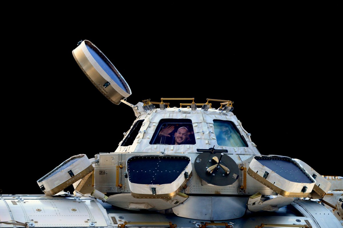
Full Earth view from ISS Cupola Impossible 100 percent Fake
page: 4share:
a reply to: eriktheawful
NASA disagrees with you, take it up with them,
NASA disagrees with you, take it up with them,
The last time anyone took a photograph from above low Earth orbit that showed an entire hemisphere (one side of a globe) was in 1972 during Apollo 17. NASA’s Earth Observing System (EOS) satellites were designed to give a check-up of Earth’s health. By 2002, we finally had enough data to make a snap shot of the entire Earth. So we did. The hard part was creating a flat map of the Earth’s surface with four months’ of satellite data. Reto Stockli, now at the Swiss Federal Office of Meteorology and Climatology, did much of this work. Then we wrapped the flat map around a ball. My part was integrating the surface, clouds, and oceans to match people’s expectations of how Earth looks from space. That ball became the famous Blue Marble.
Images of the earth may seem commonplace, but there are actually very few pictures of the entire planet. The problem, Simmon said, is all the NASA earth-observing satellites are in low-earth or geostationary orbit, meaning none of them are far enough away to see a full hemisphere. The most familiar pictures of the entire Earth are from the 1960s and 1970s Apollo missions to the moon.
a reply to: WaxingGibbons
How do they disagree with me?
I said your line in your drawing was wrong, an you lack the understanding of how line of sight and wide angle lenses work.
I didn't say anything about NASA or what they said. Only what you've stated here (which is wrong).
How do they disagree with me?
I said your line in your drawing was wrong, an you lack the understanding of how line of sight and wide angle lenses work.
I didn't say anything about NASA or what they said. Only what you've stated here (which is wrong).
originally posted by: Raggedyman
I am not a flat earther or saying anyone is
But this is a great thread, what I come to ats for
Thanks for bringing it to our attention
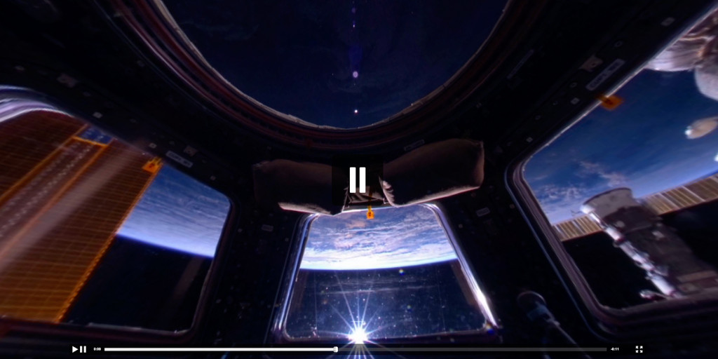
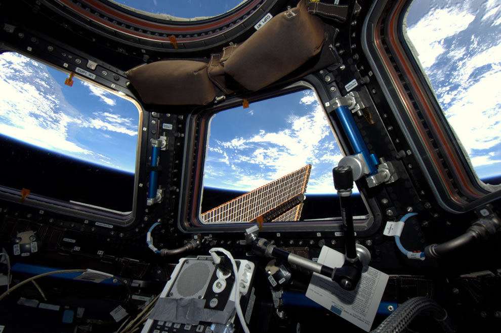
I cant see the fish eye thing being relevant how do you do that through a lens and not see more of the cockpit
And if it's just the fish eye window, why are they all in sync, they should all be different, showing different views?
What am I missing
The camera is placed exactly centered, deep into the cockpit. In all directions the distortions are equal.
originally posted by: Raggedyman
I am not a flat earther or saying anyone is
But this is a great thread, what I come to ats for
Thanks for bringing it to our attention
I cant see the fish eye thing being relevant how do you do that through a lens and not see more of the cockpit
And if it's just the fish eye window, why are they all in sync, they should all be different, showing different views?
What am I missing
The most interesting part of this thread is seeing the behavior of "intelligent" people who are in denial of blatant facts. Especially the ones who are the supposed experts.
Thanks for speaking up.
originally posted by: WaxingGibbons
a reply to: moebius
What fish eye lense? What distortion? It's not even relevant at this point. This is all you need to know,
It either shows the whole Earth, which is impossible, and I agree it doesn't, or it shows only a portion of the Earth which means it is impossible that we see a sphere with space around it. Simple as that. Take your pick, it can only be a fake in both cases.
The distortion caused by the lens used when taking that picture.
Are you really that dense?
Do yourself and everyone else a favor and look up "fisheye lens" instead of trolling like a lunatic.
You can't even admit the Dome like quality of the glass is designed to reflect the image, how can anyone take you seriously?
The Chromatic Aberration in this video is enough proof they are massively refracting the angle of light coming into them and you cannot even see through them without being at perfect center angles.
It's extremely noticeable and dramatic.(The 'Pure white' windows.)
Your example is one point scoping earth, these each have their own lines of axis they would be bending at the end together. Your example is they cant 'look through' the horizon, but they're don't need to do anything other than each one center on it. No single window showed the whole Earth.
You also seem exceedingly pissed the image is of something round. If you view the face of a ball, you're only going to see a round portion no matter how far you zoom in or out. This is because the ball is small. It's only when the round object is very large do you have the 'flat' distortions compared to the observer. Countering these with mirrors that can bend vantage points together can account for a composite image through the glass alone.
Can you redraw your example considering nearly a 175 degree lens?
edit on 25-3-2017 by MacK80 because: (no reason given)
originally posted by: WaxingGibbons
a reply to: moebius
What fish eye lense? What distortion? It's not even relevant at this point. This is all you need to know,
It either shows the whole Earth, which is impossible, and I agree it doesn't, or it shows only a portion of the Earth which means it is impossible that we see a sphere with space around it. Simple as that. Take your pick, it can only be a fake in both cases.
That is a GROSS oversimplification. That's like saying a rainbow contains two colors. Do us all a favor and read these wiki pages before you reply again:
en.wikipedia.org...
en.wikipedia.org...(optics)
a reply to: eriktheawful
The lines are drawn from the viewing height to both horizons. You can't look past the horizon, therefore it shows the exact amount of the Earth one would be able to see from that altitude.....
It was not a diagram of the view from the cupola.
The lines are drawn from the viewing height to both horizons. You can't look past the horizon, therefore it shows the exact amount of the Earth one would be able to see from that altitude.....
It was not a diagram of the view from the cupola.
edit on 25-3-2017 by WaxingGibbons because: (no reason given)
originally posted by: chrismir
originally posted by: Raggedyman
I am not a flat earther or saying anyone is
But this is a great thread, what I come to ats for
Thanks for bringing it to our attention
I cant see the fish eye thing being relevant how do you do that through a lens and not see more of the cockpit
And if it's just the fish eye window, why are they all in sync, they should all be different, showing different views?
What am I missing
The camera is placed exactly centered, deep into the cockpit. In all directions the distortions are equal.
That's silly, 7 fish eyed lenses don't, can't show show a jigsaw of the same image.
If they are fish eyed they have to show completely different images because of the angle they are pointed at. Think about it7 fish eyed lenses, it can't do what you are saying it does
Just think about it
a reply to: DrWily
Nope, it's either the one or the other. In fact we have established that it is not the entire Earth, so one scenario remains.
Why do we see only a portion of the Earth and at the same time it looks like a sphere with space around it?
The only answer is that it cannot be a real pic.
That is a GROSS oversimplification.
Nope, it's either the one or the other. In fact we have established that it is not the entire Earth, so one scenario remains.
Why do we see only a portion of the Earth and at the same time it looks like a sphere with space around it?
The only answer is that it cannot be a real pic.
edit on 25-3-2017 by WaxingGibbons because: (no reason given)
a reply to: Raggedyman
The composite you can create with 7 refracted images is COMPARABLE to a single fisheye lens.
He never said they're all explicitly fisheye, they are all designed to bend it though.
The composite you can create with 7 refracted images is COMPARABLE to a single fisheye lens.
He never said they're all explicitly fisheye, they are all designed to bend it though.
a reply to: WaxingGibbons
Good thread OP, I see what you mean
My logical guess would be that the picture consist of two pictures
One taken from the inside
And the other one taken from the outside with a fish eye lens
And then Photoshop together.
Good thread OP, I see what you mean
My logical guess would be that the picture consist of two pictures
One taken from the inside
And the other one taken from the outside with a fish eye lens
And then Photoshop together.
Again: I think you're just failing to understand how the view out the windows of the cupola works, and the use of different camera lenses.
originally posted by: WaxingGibbons
a reply to: DrWily
That is a GROSS oversimplification.
Why do we see only a portion of the Earth and at the same time it looks like a sphere with space around it?
Hahahaaha I knew it, you're just mad it composites round taking the 7 different angles. Closet Flat Earther, the fact it's round is how the windows are compositing the image. It would be 'rounder' than normal even if the Earth was flat.
a reply to: eriktheawful
The ones I posted were taken from further inside, like I said, about 2 m back from the window, but it's not relevant at this point.
Looks like the Earth curvature is almost the same as the circle of the cupola, in your pics. So the whole Earth would be visible from that viewpoint?
The ones I posted were taken from further inside, like I said, about 2 m back from the window, but it's not relevant at this point.
Looks like the Earth curvature is almost the same as the circle of the cupola, in your pics. So the whole Earth would be visible from that viewpoint?
edit on 25-3-2017 by WaxingGibbons because: (no reason given)
originally posted by: WaxingGibbons
a reply to: eriktheawful
The one I posted were taken from further inside, like I said, about 2 m back from the window, but it's not relevant at this point.
The fisheye effect makes it look like taken from 2m, while in fact it is much closer
originally posted by: WaxingGibbons
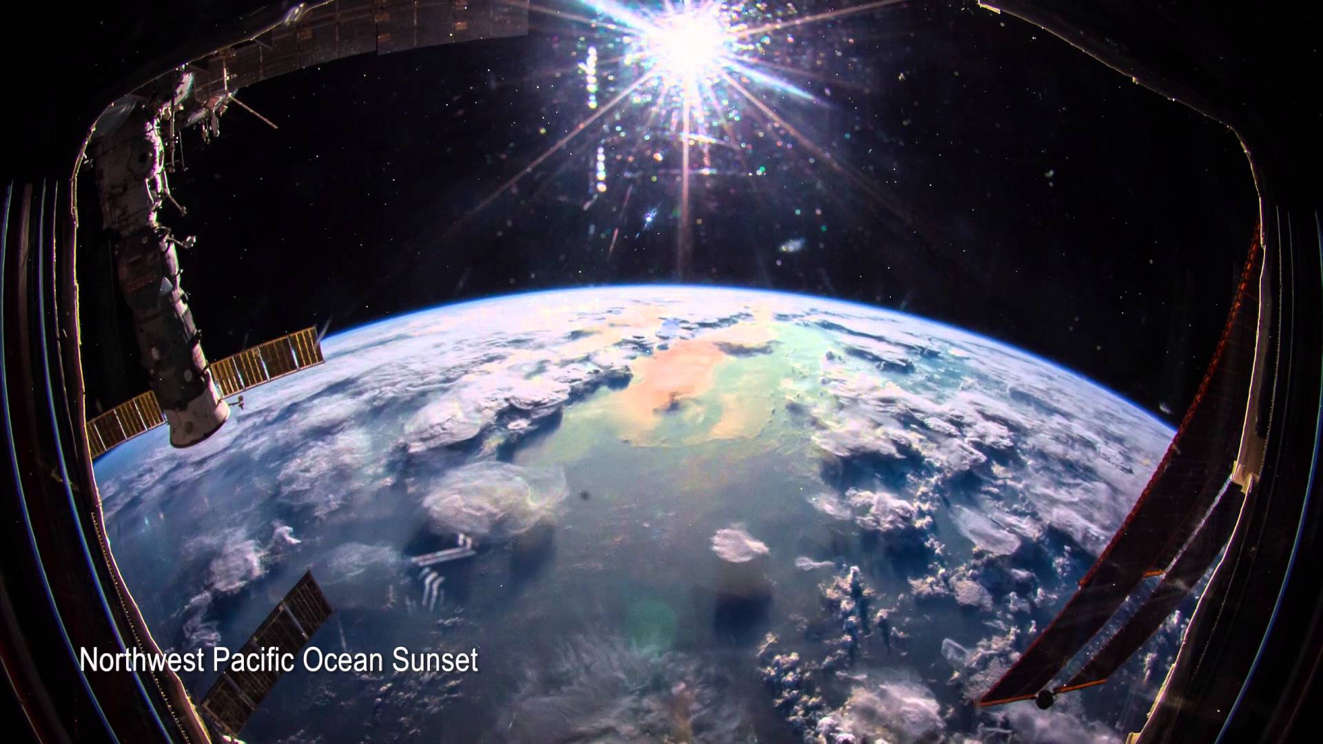
So on this site you can see a pic from the cupola that shows lake Malawi. The lake is 580 km long. It is about one third of the shot. This means we are looking at 1700/1800 kms.
We should be seeing like I calculated earlier about 4700 km of the surface. The pic is obviously not zoomed in either.
www.issphotolibrary.com...
No matter how you look at these pics, they are fake, fake, fake.......
Reposting this again. So here we are sure it is showing a 1700 km wide section of the Earth. So why does it look like a sphere with space around it?
And why does it show less of the Earth than we are supposed to see from that altitude?
a reply to: WaxingGibbons
The the angled windows on the edges, are angled, and they are, this refraction would be more intense as you backed away from the window.
It might not even be possible to see the whole earth's horizon up close to them without massive lens distortion bending the edges.
The the angled windows on the edges, are angled, and they are, this refraction would be more intense as you backed away from the window.
It might not even be possible to see the whole earth's horizon up close to them without massive lens distortion bending the edges.
edit on
25-3-2017 by MacK80 because: (no reason given)
Okay... I'm trying really hard not to get frustrated with you, but you are pushing the limits.
originally posted by: WaxingGibbons
The only answer is that it cannot be a real pic.
space.stackexchange.com...
Please read the above post on stackexchange, The guy who replies explains it better than I ever could. He spells out in extreme detail how it's possible to take the images you posted from inside the Cupola. He even gives exact camera, lens, and positional settings. There is nothing even remotely fake about this... It's just your lack of understanding about optics and your refusal to learn about it.
new topics
-
Russian intelligence officer: explosions at defense factories in the USA and Wales may be sabotage
Weaponry: 22 minutes ago -
African "Newcomers" Tell NYC They Don't Like the Free Food or Shelter They've Been Given
Social Issues and Civil Unrest: 1 hours ago -
Russia Flooding
Other Current Events: 2 hours ago -
MULTIPLE SKYMASTER MESSAGES GOING OUT
World War Three: 3 hours ago -
Two Serious Crimes Committed by President JOE BIDEN that are Easy to Impeach Him For.
US Political Madness: 4 hours ago -
911 emergency lines are DOWN across multiple states
Breaking Alternative News: 4 hours ago -
Former NYT Reporter Attacks Scientists For Misleading Him Over COVID Lab-Leak Theory
Education and Media: 6 hours ago -
Why did Phizer team with nanobot maker
Medical Issues & Conspiracies: 6 hours ago -
Pro Hamas protesters at Columbia claim hit with chemical spray
World War Three: 6 hours ago -
Elites disapearing
Political Conspiracies: 9 hours ago
top topics
-
British TV Presenter Refuses To Use Guest's Preferred Pronouns
Education and Media: 16 hours ago, 17 flags -
Go Woke, Go Broke--Forbes Confirms Disney Has Lost Money On Star Wars
Movies: 11 hours ago, 13 flags -
Pro Hamas protesters at Columbia claim hit with chemical spray
World War Three: 6 hours ago, 11 flags -
Elites disapearing
Political Conspiracies: 9 hours ago, 8 flags -
Freddie Mercury
Paranormal Studies: 11 hours ago, 7 flags -
Nirvana - Immigrant Song
Music: 15 hours ago, 5 flags -
A Personal Cigar UFO/UAP Video footage I have held onto and will release it here and now.
Aliens and UFOs: 9 hours ago, 5 flags -
African "Newcomers" Tell NYC They Don't Like the Free Food or Shelter They've Been Given
Social Issues and Civil Unrest: 1 hours ago, 5 flags -
Two Serious Crimes Committed by President JOE BIDEN that are Easy to Impeach Him For.
US Political Madness: 4 hours ago, 4 flags -
Former NYT Reporter Attacks Scientists For Misleading Him Over COVID Lab-Leak Theory
Education and Media: 6 hours ago, 4 flags
active topics
-
African "Newcomers" Tell NYC They Don't Like the Free Food or Shelter They've Been Given
Social Issues and Civil Unrest • 3 • : bally001 -
Two Serious Crimes Committed by President JOE BIDEN that are Easy to Impeach Him For.
US Political Madness • 7 • : Disgusted123 -
Russian intelligence officer: explosions at defense factories in the USA and Wales may be sabotage
Weaponry • 2 • : RussianTroll -
Russia Flooding
Other Current Events • 1 • : ksihkahe -
Running Through Idiot Protestors Who Block The Road
Rant • 107 • : FlyersFan -
The Acronym Game .. Pt.3
General Chit Chat • 7721 • : F2d5thCavv2 -
Russia Ukraine Update Thread - part 3
World War Three • 5694 • : F2d5thCavv2 -
-@TH3WH17ERABB17- -Q- ---TIME TO SHOW THE WORLD--- -Part- --44--
Dissecting Disinformation • 518 • : Guyfriday -
British TV Presenter Refuses To Use Guest's Preferred Pronouns
Education and Media • 50 • : sine.nomine -
MULTIPLE SKYMASTER MESSAGES GOING OUT
World War Three • 12 • : Zaphod58