It looks like you're using an Ad Blocker.
Please white-list or disable AboveTopSecret.com in your ad-blocking tool.
Thank you.
Some features of ATS will be disabled while you continue to use an ad-blocker.

BREAKING: Fearing collapse of emergency spillway at Oroville Dam, Oroville evacuated
page: 8share:
a reply to: Reverbs
here is 2 cents worth from google earth. if you go to street view while looking up the chute toward the dam, you will see the dry undamaged spillway. you can then compare that to the turbulence and undercut spillway halfway up in the posted pic. if the undercut would proceed to the top, it would allow oroville lake to go around the main dam. you can see how close from the google earth overhead view of the dam. Also, if you pull up, you can see how big the lake is...in the time frame of the pic there are lots of beige cliffs about the lake, indicating it was really low when taken.
please correct me if wrong, but the doom pron speculation is that what would happen. seems unlikely. i will try to post the screen grab if i can figure out ats posting hoops.
I watched them loading the bags their going to plug the hole with. What a waste of time I live on Lake Michigan and we use bigger rocks than that for
beach erosion and they go by by on a regular basis.
originally posted by: darkstar57
a reply to: Reverbs
here is 2 cents worth from google earth. if you go to street view while looking up the chute toward the dam, you will see the dry undamaged spillway. you can then compare that to the turbulence and undercut spillway halfway up in the posted pic. if the undercut would proceed to the top, it would allow oroville lake to go around the main dam. you can see how close from the google earth overhead view of the dam. Also, if you pull up, you can see how big the lake is...in the time frame of the pic there are lots of beige cliffs about the lake, indicating it was really low when taken.
please correct me if wrong, but the doom pron speculation is that what would happen. seems unlikely. i will try to post the screen grab if i can figure out ats posting hoops.
no thats not the dangerous one and I keep having to correct this.
they were worried about the head cut in the dirt erosion leading closer to the 30 foot wall, on the other side of the water slide and Dam..
the water slide part has stopped eroding even with the crazy amount of water going down it.
the other part has stopped eroding as there is no more water over there.
the actual structure of the main spillway is fine.. As well as the structure of the wall..
The situation is far from resolved, and anyone claiming otherwise is ignoring the reports. The
live stream coverage states clearly that the threat is still ongoing. More than
188,00 people have been evacuated, and are not being allowed to return home. Schools in the evacuation zone are remaining closed through at least
this Friday. more weather is expected, too, which will add to the problem, and no one knows how much as of yet.
There are serious concerns here. This article states:
So, why would we have any real confidence in the ratings for the dam itself? Are they as inaccurate? A dam engineer (connection of a connection of mine on LinkedIn) posted this:
This man has a diagram at the link, as well, and from what I am told, wants this information shared, so posting it here to aid in that. No, the situation is not under control.
As for the appearance, spillway, etc - here is a screen shot from a video, taken by a drone flying over the dam and spillway. The main dam, you can see on the right, with the spillway in question to the left. That spillway is mostly earthen, please note.
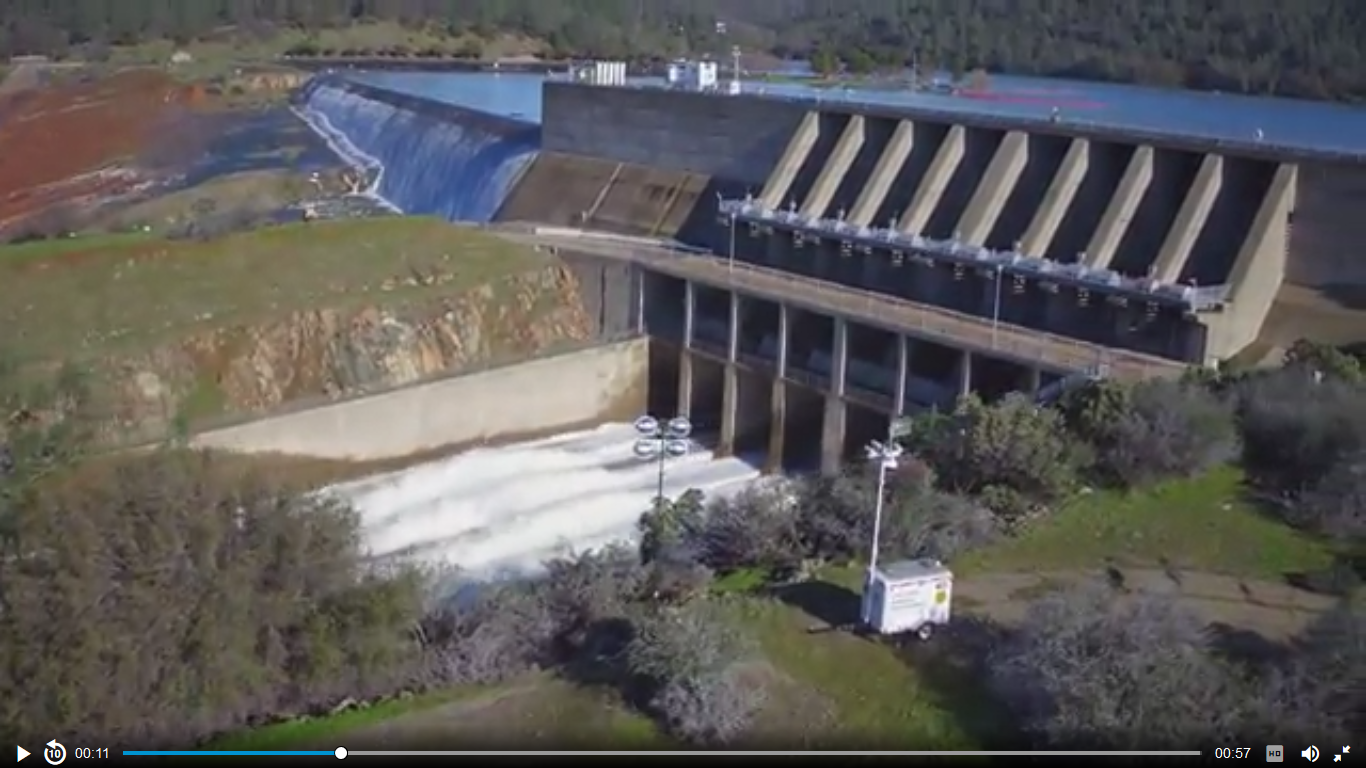
link for video
As for the spillway issue, let's be clear there as well. Yes, ther are two, but both have problems, as discussed in this article:
Note, too, that they say this about flash flooding:
No evacuation orders are being lifted, they say, until they know for certain the threat is gone. Storms are coming. If they are cold, as weather people are hoping, they won't be so bad. If warmer, though, they will ad not only rain, but snow melt, which will be a lot worse.
This is a very real, and very serious threat. The problems really were ignored, and that's an issue. How much money has California spent on illegals, that could have instead been spent addressing the issues with this dam?
There are serious concerns here. This article states:
Department engineer and spokesman Kevin Dossey told the Sacramento Bee the emergency spillway was rated to handle 250,000 cubic feet per second, but it began to show weakness Sunday after flows peaked at 12,600 cubic feet per second.
So, why would we have any real confidence in the ratings for the dam itself? Are they as inaccurate? A dam engineer (connection of a connection of mine on LinkedIn) posted this:
As I write the Oroville dam in California is eroding back toward a breach of the reservoir. I am a dam contractor. If you ever heard someone say "that dam contractor.." they may have been talking about me.
I have repaired hundreds of dams including ones like Oroville, which were in the process of failure. I know a lot about dams.
The spillway failure is a common type of failure, where phreatic, or surface water entered the spillway, migrating beneath the slabs. (A static element on a dynamic element, A hard element on a live element). The dam is hydrated and dehydrated as water levels rise and fall, moving, as soils swell from pressures and water mass. In times of high rain the phreatic surface (hydrated soils line) moves toward the surface, venting into the void so produced.
This creates a void. Moving water over the years has eroded soils from beneath the slab downstream and left a channel. Now, the spillway has been actuated in a high-flow event and the plates of the spillway have failed into the stream, scouring from beneath them. They will continue to fail as the water continues to flow. The hydraulic jump exacerbates this erosion.
If the flow continues for a long enough time, with sufficient velocity, the reservoir will be voided by the migration of the erosion to the pool (cut-back). I cannot tell if failure is imminent, from Ohio, but it is an unacceptable situation that has been allowed to develop. It is a case of pennies pinched producing dollars spent, perhaps tragedy.
What we can learn as a nation is the information that is being disseminated. Words chosen carefully, to not excite, to not scare. The issue, as it now stands is serious, life-threatening even. The officials, the owners reps, the media will tell us now, that there is nothing to be be frightened about - all under control (remember Katrina??).
We have, for so long, ignored the failing infrastructure of this great nation, Let us hope that a fatal failure is not necessary to get us to act. Past experience does not make me hopeful of that.
Oroville is 770' high, 6,920' long. It is one of the 20 largest dams in the world. If Oroville breaks, The city will be flooded.
Eight thousand three hundred and seventy five residents are at risk within the inundation zone. Two hundred thirty critical facilities in the city of Oroville are within the inundation zone, including; Eleven schools, twenty one day care and children service centers, fourteen elder care facilities, twenty six bridges will be lost, the airport, two fire stations, the government administration building, three law enforcement stations, the EMERGENCY OPERATIONS CENTER (brilliant) Two waste water treatment plants, the jail, and the Hospital. (from the City of Oroville local hazard mitigation plan update May, 2013)
We are not talking about a river rising, where people have time to evacuate. We are talking about a wall of debris, mud, and water taking out a city, buildings, roads, bridges, life, in a horrible instant.
When will we, at last mandate proper maintenance and inspection of these high hazard and medium hazard dams? Why are we willing to suffer a loss of hundreds of millions of dollars to save a couple of dollars on proper and responsible dam safety and repairs?
Whatever you may hear, this is a significant event which could be horrible in its scope and its magnitude. Let us pray that it does not breach, and let us hope that, at last people are sufficiently concerned to act. Scott Cahill
This man has a diagram at the link, as well, and from what I am told, wants this information shared, so posting it here to aid in that. No, the situation is not under control.
As for the appearance, spillway, etc - here is a screen shot from a video, taken by a drone flying over the dam and spillway. The main dam, you can see on the right, with the spillway in question to the left. That spillway is mostly earthen, please note.
link for video
As for the spillway issue, let's be clear there as well. Yes, ther are two, but both have problems, as discussed in this article:
The Oroville Dam provides flood control for the region. The dam has two spillways to release water out of the lake to prevent overflow. Both have problems. In the main spillway, which is lined, or paved, erosion has caused a hole almost the size of a football field and at least 40-feet deep to form in the lower part of the channel. It can't be fixed immediately. "You don't throw a little bit of rock in it," said DWR acting director Bill Croyle. The emergency spillway, which is an embankment covered with trees, is a last resort and was used for the first time in history on Saturday when the lake topped 901 feet, its capacity, and a light flow of water washed into the spillway. Around 3 p.m. (6 p.m. ET) Sunday, authorities learned that the emergency spillway was also eroding, Butte County Sheriff Kony Honea said.
Note, too, that they say this about flash flooding:
The Sacramento Fire Department echoed the urgency and warned residents that the spillway failure could have effects, including flash flooding, 75 miles downstream in Sacramento.
No evacuation orders are being lifted, they say, until they know for certain the threat is gone. Storms are coming. If they are cold, as weather people are hoping, they won't be so bad. If warmer, though, they will ad not only rain, but snow melt, which will be a lot worse.
This is a very real, and very serious threat. The problems really were ignored, and that's an issue. How much money has California spent on illegals, that could have instead been spent addressing the issues with this dam?
originally posted by: Miracula2
originally posted by: Reverbsand they do know what they are doing.
How thick was that spillway? It looked pretty thin to me. Hasn't been used in 48 years? Maybe time to upgrade it before it gets dangerous.
be more specific.. The main spillway is used on a regular basis.
when it developed a hole on the water slide they shut it off.
Because the main way to drain the water was off the let it go to emergency spill, but then the dirt over on the side of the hill was eroding unexpectedly so they were like #, better just erode the water slide..
the emergency spill way was never used in the past.
the wall is fine..
it's the dirt in front of the wall that was getting head cut.. meaning a waterfall type spot was forming, and the waterfall was tracking back towards the wall..
there is no longer any water over there as they drained the lake quite a bit.
a reply to: LadyGreenEyes
Your picture is of the 2 spillways neither is the Dam which is much larger and to the right out of frame.
You don't even know what you are looking at.
This is the problem. The news confused two elements again and again..
there is no erosion at the spillway that is a 30 foot wall. No current erosion.
It's not safe to use theat spillway and obviously they won't until a huge fix is made..
Point is they expect to get the lake down 80 feet and the water wont even be up to the wall in the first place.
I bet you'll see the evacuations ceased in 1-2 days.
the flash flood warnings are about to expire and they didn't renew them. (those were for the 30 foot wall possibly collapsing)
unless you guys are expecting 700 feet of earth and concrete to just disappear for no reason. (main spillway )
you'll see soon enough.
I'd bet you $1000 dollars if I had it.
edit on 13-2-2017 by Reverbs because: (no reason given)
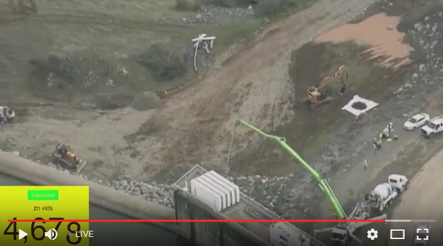
It appears they have made real progress shoring up the erosion below the auxiliary/emergency spillway. Since they have reduced the lake water level
and have had access to the leeward side where the erosion was taking place, they have placed large boulders and are pumping concrete into them.
Note: these images are mirrored(left is right, and vice versa...stoopid feed is mirrored confusing this whole thing)
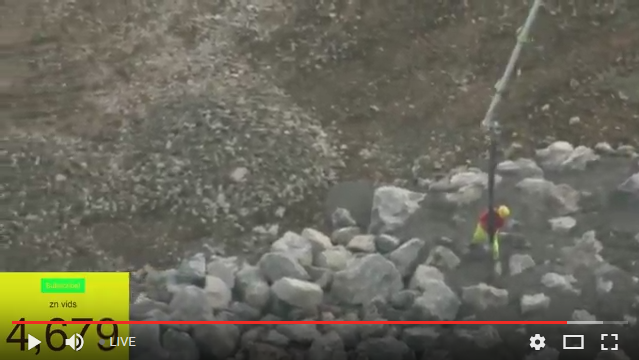
here you can clearly see there is no water flowing over the emergency spillway and appears to be a few feet blow the crest. Lower left of the image.
For reference this is what it was like earlier(today?).

An image from yesterday evening as the evacuation order was taking place. This image is in the correct perspective, emergency spillway in the middle, the main spillway to the immediate right, and a slice of the main dam upper right.
This is/was the area of main concern for this evacuation taking place.
Note: these images are mirrored(left is right, and vice versa...stoopid feed is mirrored confusing this whole thing)
here you can clearly see there is no water flowing over the emergency spillway and appears to be a few feet blow the crest. Lower left of the image.
For reference this is what it was like earlier(today?).
An image from yesterday evening as the evacuation order was taking place. This image is in the correct perspective, emergency spillway in the middle, the main spillway to the immediate right, and a slice of the main dam upper right.
This is/was the area of main concern for this evacuation taking place.
edit on 2/13/2017 by jappee because: (no reason given)
It is all about more rain and hopefully not more serious erosion...Prayers and hopefully they can build the dam better.I don't know what is up with
the mirrored effect.Just found a link randomly online.
I also know the dam is fine and they are concerned ubout 2 areas of erosion.
edit on 13-2-2017 by Jobeycool because: (no reason given)
I also know the dam is fine and they are concerned ubout 2 areas of erosion.
edit on 13-2-2017 by Jobeycool because: (no reason
given)
edit on 13-2-2017 by Jobeycool because: (no reason given)
So I am here to find out the latest on the emergency. How are evacuations going? What is the latest news? Any more reports of looting or traffic jams
out of the area? Most importantly what is the latest news in light of the rain expected?
a reply to: LadyGreenEyes
Thanks for the update and thread.
Also has anyone discussed Gov Brown and how he is taking action or not? I last heard he was very busy getting "funding" and back up plans of National guard etc. in place, but not really releasing info to the public?
Also how are the evacuations going? gas stations ran out last I heard and some looting began last night?
Just now jumping in to find out some info. Also is there a list of the affected towns and cities in worst case scenario? Has anyone talked about displacement pressure that could cause a major earthquake? Although the dam is well over due for upgrades and repairs, how close was the nearest fracking operation to the dam?
a reply to: antar
You may want to try following the link in MY OP.
It has an effected ares map further down the page.
As for looting, i have no idea. but we are talking about Oroville, it's bound to happen.
Why do you have to bring fracking into this?? It's not relevant in any way.
I'll make it easy for you...It has been updated several times.
BREAKING: No word when evacuation order for 188,000 will be lifted as Oroville threat remains
Also see my post above it has images of the ongoing temporary repairs to the emergency spillway, which was the cause of the evacuation. And it seems to be under control for the time being.
edit on 2/13/2017 by jappee because: (no reason given)
originally posted by: antar
a reply to: LadyGreenEyes
Also has anyone discussed Gov Brown and how he is taking action or not?
I suspect Governor Moonbeam is trying to keep his head down low at the moment. He recently submitted a list to Trump of 50 "vital" infrastructure projects that need funding, including raising Folsom Dam... but completely ignored the known issues and outstanding repairs related to Oroville. Once again, stupid ideas take priority, and this time it's coming back to bite Moonbeam in the ass.
From the link in the OP;
Governor issues emergency order to assist in dealing with Oroville Dam crisis Gov. Jerry Brown’s office said he has issued an emergency order to help authorities deal with the evacuation and other efforts associated with concerns over the potential for flooding from Oroville Dam spillways. “I’ve been in close contact with emergency personnel managing the situation in Oroville throughout the weekend, and it’s clear the circumstances are complex and rapidly changing,” Brown said. “I want to thank local and state law enforcement for leading evacuation efforts and doing their part to keep residents safe. The state is directing all necessary personnel and resources to deal with this very serious situation.” State emergency services officials are planning an 11 p.m. press conference to discuss their efforts.
originally posted by: Miracula2
originally posted by: Reverbsand they do know what they are doing.
How thick was that spillway? It looked pretty thin to me. Hasn't been used in 48 years? Maybe time to upgrade it before it gets dangerous.
they had the info on the state of the spillway 10 years ago. gotta love our politicians. whats funny is it is rated to move 250,000 cubic feet of water a second yet it started failing before it even reached 10K cfs over less then a 24 hour period. i want some butts
originally posted by: jappee
From the link in the OP;
Governor issues emergency order to assist in dealing with Oroville Dam crisis Gov. Jerry Brown’s office said he has issued an emergency order to help authorities deal with the evacuation and other efforts associated with concerns over the potential for flooding from Oroville Dam spillways. “I’ve been in close contact with emergency personnel managing the situation in Oroville throughout the weekend, and it’s clear the circumstances are complex and rapidly changing,” Brown said. “i want to thank local and state law enforcement for leading evacuation efforts and doing their part to keep residents safe. The state is directing all necessary personnel and resources to deal with this very serious situation.” State emergency services officials are planning an 11 p.m. press conference to discuss their efforts.
if only our politicians in the state would quit appropriating/stealing our money earmarked for infrastructure repairs and upkeep we wouldnt need to be put into a situation like this where we need protecting from their incompetence.
ffs why does the qoute system suck so bad on ATS. the part qouted shows up in my post prior to posting but gets deleted when posted
edit on 13-2-2017 by TheScale because: (no reason given)
new topics
-
God's Righteousness is Greater than Our Wrath
Religion, Faith, And Theology: 1 hours ago -
Electrical tricks for saving money
Education and Media: 4 hours ago -
VP's Secret Service agent brawls with other agents at Andrews
Mainstream News: 5 hours ago -
Sunak spinning the sickness figures
Other Current Events: 6 hours ago -
Nearly 70% Of Americans Want Talks To End War In Ukraine
Political Issues: 6 hours ago -
Late Night with the Devil - a really good unusual modern horror film.
Movies: 8 hours ago -
Cats Used as Live Bait to Train Ferocious Pitbulls in Illegal NYC Dogfighting
Social Issues and Civil Unrest: 9 hours ago -
The Good News According to Jesus - Episode 1
Religion, Faith, And Theology: 11 hours ago
top topics
-
Florida man's trip overseas ends in shock over $143,000 T-Mobile phone bill
Social Issues and Civil Unrest: 16 hours ago, 8 flags -
Cats Used as Live Bait to Train Ferocious Pitbulls in Illegal NYC Dogfighting
Social Issues and Civil Unrest: 9 hours ago, 8 flags -
VP's Secret Service agent brawls with other agents at Andrews
Mainstream News: 5 hours ago, 8 flags -
Bobiverse
Fantasy & Science Fiction: 16 hours ago, 3 flags -
HORRIBLE !! Russian Soldier Drinking Own Urine To Survive In Battle
World War Three: 13 hours ago, 3 flags -
Electrical tricks for saving money
Education and Media: 4 hours ago, 3 flags -
Nearly 70% Of Americans Want Talks To End War In Ukraine
Political Issues: 6 hours ago, 3 flags -
Sunak spinning the sickness figures
Other Current Events: 6 hours ago, 3 flags -
Late Night with the Devil - a really good unusual modern horror film.
Movies: 8 hours ago, 2 flags -
The Good News According to Jesus - Episode 1
Religion, Faith, And Theology: 11 hours ago, 1 flags
active topics
-
VP's Secret Service agent brawls with other agents at Andrews
Mainstream News • 36 • : SchrodingersRat -
The Acronym Game .. Pt.3
General Chit Chat • 7744 • : bally001 -
Truth Social goes public, be careful not to lose your money
Mainstream News • 128 • : Astyanax -
New whistleblower Jason Sands speaks on Twitter Spaces last night.
Aliens and UFOs • 53 • : pianopraze -
Sunak spinning the sickness figures
Other Current Events • 5 • : glen200376 -
SETI chief says US has no evidence for alien technology. 'And we never have'
Aliens and UFOs • 44 • : MikeDeGrasseTyson -
HORRIBLE !! Russian Soldier Drinking Own Urine To Survive In Battle
World War Three • 31 • : budzprime69 -
How ageing is" immune deficiency"
Medical Issues & Conspiracies • 33 • : rickymouse -
The Reality of the Laser
Military Projects • 46 • : Zaphod58 -
God's Righteousness is Greater than Our Wrath
Religion, Faith, And Theology • 0 • : randomuser2034