It looks like you're using an Ad Blocker.
Please white-list or disable AboveTopSecret.com in your ad-blocking tool.
Thank you.
Some features of ATS will be disabled while you continue to use an ad-blocker.

BREAKING: Fearing collapse of emergency spillway at Oroville Dam, Oroville evacuated
page: 6share:
a reply to: tikbalang
We have had plenty of water,this is the libtards way of creating a crisis,like lakes and rivers going dry,they don't say they had diverted the water,now kind of hard to hide it now,had they been forthcomming this disaster may have been diverted,all for the elite to get richer
We have had plenty of water,this is the libtards way of creating a crisis,like lakes and rivers going dry,they don't say they had diverted the water,now kind of hard to hide it now,had they been forthcomming this disaster may have been diverted,all for the elite to get richer
Just for perspective the water flow over the American Falls at Niagara.
www.niagarafallslive.com...
Volume of water: 150,000 U.S. Gallons / 567,811 Liters per second
www.niagarafallslive.com...
a reply to: Caver78
That's crazy...
Niagara falls is 84,000 cubic feet per second, and that ONE spillway is going at 100,000 cubic feet per second?
But yea, that's why I'm saying the water level is dropping faster than it would be able to be replenished..
Outdoing Niagara falls..
This LA times article came out about 3.5 hours ago.
Live updates: Flooding threat at Oroville Dam eases slightly but evacuations remain
originally posted by: Reverbs
originally posted by: corblimeyguvnor
a reply to: Reverbs
Hope you're right
you don't have to hope, everything I said is a fact..
were you watching the press confrences or paying attention to the water levels?
Do you know which part of the spillways are damaged or anything that's going on?
The part that was dangerous, no longer has 1.5 feet of water rushing over the top.. later it was down to 2 inches over the top, and now it's another foot lower than that..
the combined effect of rain and other water many days from now is like 4 inches, not feet..
the real damage on the spill way is only to a "water slide" and really has nothing to do with the structure that holds the water.
And yet the water level was rising by > 1 ft per hour at peak points over the last few days. Even doubling the outflow to 100,000 cfm is still not going to match the potential inflow if the weather hits as expected.
I don't think the "combined effect of rain and other water" is just going to be "4 inches".
I hope they move out as much water as they can in this bit of breathing space they have. There is a limit on how much they can move, as once the water goes below the level of the main spillway they will not be able to release any more until they undo the mess in the generator rooms.
The emergency spillway is 901', but I'm not sure of the elevation at which the main spillway stop being effective. That difference is the breathing space they can create for themselves.
a reply to: EvillerBob
They let it get that high by not using the main spillway as much since it developed the sinkhole on the ramp..
they doubled the output now and I watched what it did to the actual water levels..
They dropped really fast.. From 1.5 feet over the emergency spill way to under the emergency spill way in a few hours.
That's multiple feet of water..
the rain coming on thursday or friday is .5 to 1 inches.
How is that going to match the speed of the water level going down?
The snow melt can't make up for it either.
originally posted by: Reverbs
a reply to: Caver78
That's crazy...
Niagara falls is 84,000 cubic feet per second, and that ONE spillway is going at 100,000 cubic feet per second?
On Thursday evening, inflow hit a peak of 190,000 cfs. They've recorded peaks of 250,000 cfs back in the 60's.
The dam's flood management systems are already compromised. What happens now depends entirely on how forgiving mother nature decides to be - but it's entirely possible that things could get very bad in the near future.
a reply to: EvillerBob
Thank You for your information.
I'm sorry but it looks like I was wrong to think this situation is in the clear.
still currently we are at 40,000 cubic feet per second in
and 100,000 cubic feet per second out.
So a Net of 60,000 cubic feet per second out, which is why I think the lake itself has lowered about 4 feet.
edit on 13-2-2017 by Reverbs because: (no reason given)
a reply to: Reverbs
Just wanted to say that I've appreciated your input.
Like EvillerBob, I have concerns with the upcoming storm days. The last storm system had rain at the 9000 ft level in the southern Sierras, leaving a couple thousand feet of snow below that to have some melt. The next system is expected to be colder.... good news so far.
This Fall and now has been constant systems with snow coming through, not quite typical. We usually get a big dump of snow in February, so we'll see what this next one does. And all that snow is good if it melts gradually; we'll see what's ahead for Spring.
It seems to me that there would be a lot more releases from all the dams this year, to account for rain and melting snow (maybe enough to fill Tulare Lake this year). I know dams have to retain for agricultural use; Spring and Summer will be interesting to watch lake sizes and downriver flows. If anything, groundwater can be replenished!
My heart goes out to all those people affected by Oroville. I would hate to go through that. Knock on wood.
originally posted by: Reverbs
a reply to: EvillerBob
the rain coming on thursday or friday is .5 to 1 inches.
Wouldn't that depend on the size of the combined river basin drainage that feed the lake? How many rivers? How many streams feed the main river/s? Creeks. Total land area combined?
Update: I just found the size of the drainage base.
....The river's drainage basin above Lake Oroville is 3,222 square miles
edit on 13-2-2017 by Miracula2 because: (no reason given)
a reply to: Miracula2
I was just wondering about drainage area.
Some of that rain would fall and remain as snow higher up, nature's water storage for California.
And that is why this was interesting to me
"250,000 cfs back in the 60's" !
The 1960s flooding was what prompted much of the "flood control" dam building along the central and northern CA mountains. Many towns were under as much as 5ft of water. I think it was "50 year storms" in the 1960s.... well, 50 years later now.
About 20 years ago we had one warm storm come through that melted rain and caused flooding and damage upriver, with warnings below. That was only one storm around late December. This year it is one storm system after another.
I was just wondering about drainage area.
Some of that rain would fall and remain as snow higher up, nature's water storage for California.
And that is why this was interesting to me
originally posted by: EvillerBob
On Thursday evening, inflow hit a peak of 190,000 cfs. They've recorded peaks of 250,000 cfs back in the 60's.
The dam's flood management systems are already compromised. What happens now depends entirely on how forgiving mother nature decides to be - but it's entirely possible that things could get very bad in the near future.
"250,000 cfs back in the 60's" !
The 1960s flooding was what prompted much of the "flood control" dam building along the central and northern CA mountains. Many towns were under as much as 5ft of water. I think it was "50 year storms" in the 1960s.... well, 50 years later now.
About 20 years ago we had one warm storm come through that melted rain and caused flooding and damage upriver, with warnings below. That was only one storm around late December. This year it is one storm system after another.
originally posted by: dreamingawake
...
Pets:
Sadly many people are having to leave pets behind. Please accommodate them if so, such as food, water and a dry space if the home floods.
...
That makes me sad and angry.
How and why would anyone leave their pets behind?
I would take my dog even if I had to hold my 80lb dog on my lap and sleep in a car or outside.
No way would I leave her behind.
a reply to: EvillerBob
I posted this about my near future concerns in the other thread.
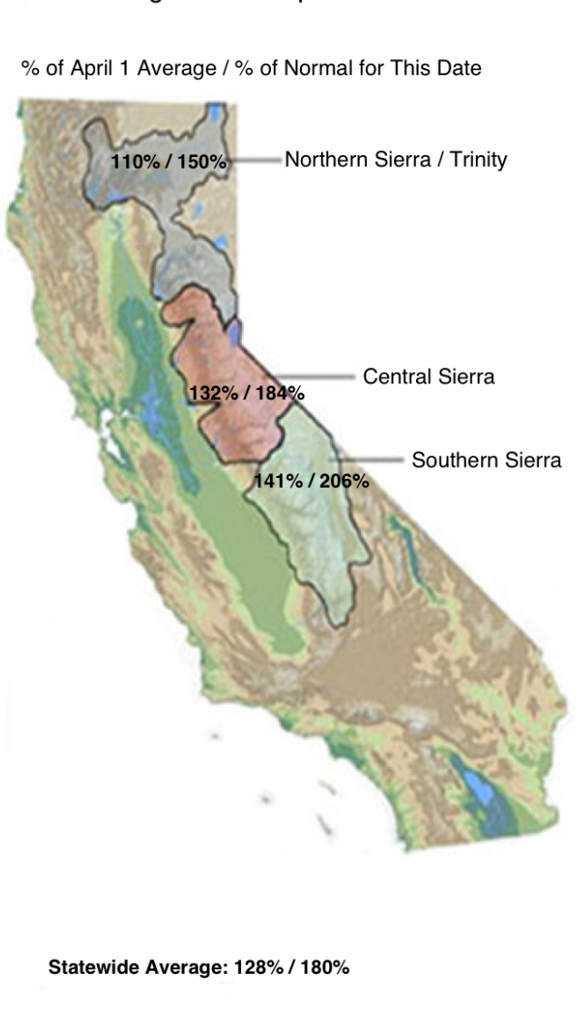
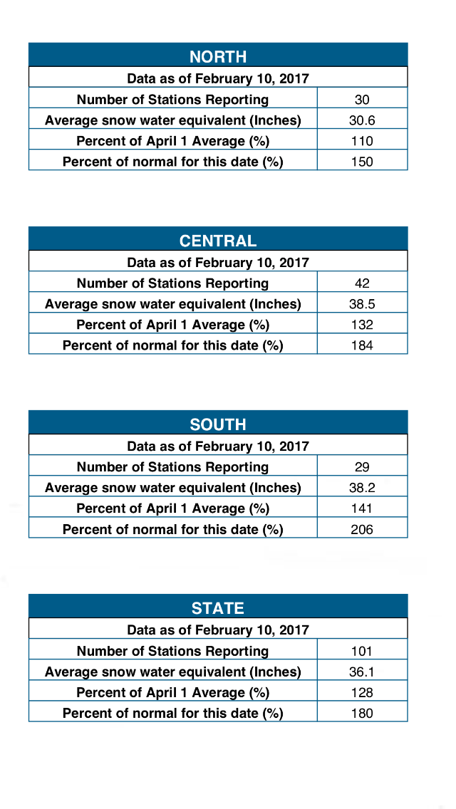
Here are some current stats on the snowpack water equivalent link
It's not the amount that worries me its the potential for rapid movement of water, rapid erosion and the increase pressure on poorly maintained dams.
The dam's flood management systems are already compromised. What happens now depends entirely on how forgiving mother nature decides to be - but it's entirely possible that things could get very bad in the near future.
I posted this about my near future concerns in the other thread.
Here are some current stats on the snowpack water equivalent link
It's not the amount that worries me its the potential for rapid movement of water, rapid erosion and the increase pressure on poorly maintained dams.
edit on 13-2-2017 by Observationalist because: (no reason given)
That dam on the sides looks like it could give way at any time.They said they believe the dam is safe now.It is the sides I would not trust at all.
originally posted by: Miracula2
a reply to: Miracula2
1 inch of rain @ 3,222 square miles = 17,842,176 gallons of water headed towards Lake Oroville
However, Thursday the weather forecast is calling for .5 inches. The day after, 1 inch. In the 10 day forecast.
It's an additional day with .5 and another day with 1. For a grand total of 3 inches. = 53,520,000 gallons over the next 10 days from the entire Lake Oroville drainage basin.
AND....
AND....
The night temps for the next 10 days are supposed to be 10 degrees above freezing. Daytime temps 50 to 65. So add more water as the snow melts to the 53 million gallons. The snow pack this year is the peak for 22 years.
Doom on.
edit on 13-2-2017 by Miracula2 because: (no reason given)
If that land erosion gives way that might all collapse,no way they can tell what is going on underneath all that erosion.That would be a total
disaster.That could happen at anytime.
originally posted by: Jobeycool
If that land erosion gives way that might all collapse,no way they can tell what is going on underneath all that erosion.That would be a total disaster.That could happen at anytime.
Well, they WOULD HAVE been able to tell with some of that seismic equipment or sonar they use to find oil fields before the spillway needed to be used.
But we had to use the money for welfare programs for illegal immigrants and their kids.
They are going to let the people back to their homes.I would never move back their.Soon as more erosion gets worse that place will collapse.No way you
know for sure how erosion can happen,kind of like a sink hole.Rain will never help.Got to be crazy to return to your home in the most dangerous
areas.
It is also a earthquake prone area which should have never been built in IMO to begin with..
It is also a earthquake prone area which should have never been built in IMO to begin with..
edit on 13-2-2017 by Jobeycool because: (no reason
given)
edit on 13-2-2017 by Jobeycool because: (no reason given)
new topics
-
How does my computer know
Education and Media: 1 hours ago -
USO 10 miles west of caladesi island, Clearwater beach Florida
Aliens and UFOs: 5 hours ago
top topics
-
Anti-Israel Protesters in CHICAGO Chant 'Death to Israel and 'Death to America'
Social Issues and Civil Unrest: 17 hours ago, 15 flags -
Running Through Idiot Protestors Who Block The Road
Rant: 16 hours ago, 12 flags -
Tesla cutting 14,000 jobs
Global Meltdown: 14 hours ago, 6 flags -
Israel ufo shoot down drones?
Aliens and UFOs: 14 hours ago, 6 flags -
USO 10 miles west of caladesi island, Clearwater beach Florida
Aliens and UFOs: 5 hours ago, 6 flags -
Abortions in first 12 weeks should be legalised in Germany, commission says
Medical Issues & Conspiracies: 14 hours ago, 5 flags -
On this Day in History, April 15, 1865, Abraham Lincoln Passed Away.
General Chit Chat: 14 hours ago, 4 flags -
How does my computer know
Education and Media: 1 hours ago, 0 flags
active topics
-
President BIDEN Warned IRAN Not to Attack ISRAEL - Iran Responded with a Military Attack on Israel.
World War Three • 38 • : TinfoilTophat -
How does my computer know
Education and Media • 1 • : UpIsNowDown2 -
Canadian Police Urge Citizens To Avoid Conflict With Armed Robbers By Leaving Keys At Front Door
Social Issues and Civil Unrest • 68 • : Astyanax -
Gold and silver prices....woo hoo
History • 71 • : SchrodingersRat -
Afterlife, unknown, so prepare, or just go into the unknown (bad)!!
ATS Skunk Works • 49 • : Kennyb75 -
Fossils in Greece Suggest Human Ancestors Evolved in Europe, Not Africa
Origins and Creationism • 46 • : matafuchs -
America's Infant Mortality Rate Increases for the First Time in 20 Years
Medical Issues & Conspiracies • 17 • : nugget1 -
Mandela Effect - It Happened to Me!
The Gray Area • 98 • : BeTheGoddess2 -
The Truth About Jesus
Conspiracies in Religions • 265 • : glend -
J Balvin Columbian Singer captured this Triangle UFO footage…….
Aliens and UFOs • 13 • : magicai