It looks like you're using an Ad Blocker.
Please white-list or disable AboveTopSecret.com in your ad-blocking tool.
Thank you.
Some features of ATS will be disabled while you continue to use an ad-blocker.

Guy explains flat Earth theory convincingly and how round earth proof aren't absolute
page: 3share:
a reply to: PoetryInMotion
Ok, lets put this another way.
The claim is that the earth is flat. It isn't. The sun is precisely as far away as orbital models predict it to be, as is the moon, and as are Mercury, Venus, Mars, and all the rest. So no matter which way you cut it, no matter what linguistic hoop you jump through to make it SOUND reasonable, it bloody well is not reasonable, or in fact, accurate to say that the planet upon which we stand, is anything other than an oblate spheroid, ergo, round, not flat.
a reply to: PoetryInMotion
If you refuse to comprehend, there is no point in continuing to ask the question.
The points made in the video and by the OP are moot, because the earth is round. And for your information, any sphere which is not perfect, and bulges outward as ours does, cannot be called a simple sphere, hence the distinction.
a reply to: icyboy771z
Google "GoPro in space." You'll find elementary school students tie GoPro to weather ballons and send them into the atmosphere. You can plainly see the earth is round.
Google "GoPro in space." You'll find elementary school students tie GoPro to weather ballons and send them into the atmosphere. You can plainly see the earth is round.
a reply to: PoetryInMotion
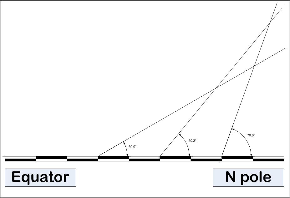
2 – POLARIS
Using a sighting of polaris to determine latitudes between the north pole and the equator is simple
And can be paraphrased thus :
“ take a sighting of polaris from any point north of the equator , and the angle at which polaris appears above the TRUE horizon is the latitude “
Now the flat earth claim immediately crumbles here
Because in reality – the lines of latitude are equidistant [ and even flat earther fantasy maps draw latitude lines equidistant ]
See pic :
This can be tested with a map – the measured distances between equal increments of latitude IS identical – do try this at home kids
Now lets demonstrate the flat earth siliness
This pic shows an alledged “ flat earth from the equator to the north pole – with the scale bar delineating 10 degree incriments of latitude
As shown – the flat earth delusion fails the polaris test – one obersvational dataset in – and the flat earth delusion has crashed
Spheriod earth model handles polaris observations perfectly
But hey – lets crash on
there - you now have the polaris explaination in thread - accept it or offer your rebuttal
a reply to: neveroddoreven99
Fish eye lenses tend to make things look curved. What about all those similar vids not showing any curvature whatsoever?
Fish eye lenses tend to make things look curved. What about all those similar vids not showing any curvature whatsoever?
a reply to: ignorant_ape
So that's your FE debunk, thnat Polaris appears lower the further to the South you are? I can easily counter this and say it is caused by perspective on a flat plane. The further away you are from an object the lower it appears in relation to the horizon.
So that's your FE debunk, thnat Polaris appears lower the further to the South you are? I can easily counter this and say it is caused by perspective on a flat plane. The further away you are from an object the lower it appears in relation to the horizon.
a reply to: PoetryInMotion
I knew you would reply this to him. I just smelled it. Can you bring examples for your similar videos? You can post them right here if they are on youtube.
I knew you would reply this to him. I just smelled it. Can you bring examples for your similar videos? You can post them right here if they are on youtube.
a reply to: TrueBrit
I see, so pointing out that the socalled proof for Globe Earth is not actually proof per se, is a lie, because Earth is round......
Again, this is not a lie.
If you drew a circle with the same supposed amount of oblateness as Earth you wouldn't even notice it. But hey, it sure sounds interesting.
Oblate spheroid.
The points made in the video and by the OP are moot, because the earth is round.
I see, so pointing out that the socalled proof for Globe Earth is not actually proof per se, is a lie, because Earth is round......
Again, this is not a lie.
And for your information, any sphere which is not perfect, and bulges outward as ours does, cannot be called a simple sphere, hence the distinction.
If you drew a circle with the same supposed amount of oblateness as Earth you wouldn't even notice it. But hey, it sure sounds interesting.
Oblate spheroid.
edit on 13-10-2016 by PoetryInMotion because: (no reason given)
a reply to: PoetryInMotion
oh - come on at least TRY - if you are going to invoke " perspective " then explain why the angular size of polaris is identical at all lattitudes
you cannot pick half an explaination and simply ignore the bit that contradicts you
oh - come on at least TRY - if you are going to invoke " perspective " then explain why the angular size of polaris is identical at all lattitudes
you cannot pick half an explaination and simply ignore the bit that contradicts you
edit on 13-10-2016 by ignorant_ape because: (no reason
given)
a reply to: ignorant_ape
First you explain why the angular size is identical at all lattitudes of Globe Earth.
if you are going to invoke " perspective " then explain why the angular size of polaris is identical at all lattitudes
First you explain why the angular size is identical at all lattitudes of Globe Earth.
a reply to: PoetryInMotion
You would if you had any bloody perception what so ever. Good grief.
All you have demonstrated is that you have no respect for either reality, or precision, both of which are fundamental underpinnings of forming useful thought on scientific matters.
You would if you had any bloody perception what so ever. Good grief.
All you have demonstrated is that you have no respect for either reality, or precision, both of which are fundamental underpinnings of forming useful thought on scientific matters.
a reply to: ignorant_ape
and here - using the cn tower as my example is why wou are utterly wrong
as per your claim - the height of the CN tower is PERCIEVED as shorter - the further the observer is from its base
but the observation that falsifies your claim - is the simultaneous observation that the width of the pain pod is PERCIEVED to be smaller - the more distant it is
thats perspective
now - back in the real world - the size of polaris is PERCIEVED to be identical from any point on earth where it is visible
this is NOT perspective
you are wrong - QED
Great video here from V Sauce it shows what would actually happen If the world was flat.
Isn't happening so it isn't flat.
Isn't happening so it isn't flat.
a reply to: ignorant_ape
(removed misinterpretation)
So how does the Globe model explain this, if you go further South you put more distance between you and Polaris even on a globe, so how do you explain why the angular size doesn't change?
(removed misinterpretation)
now - back in the real world - the size of polaris is PERCIEVED to be identical from any point on earth where it is visible
So how does the Globe model explain this, if you go further South you put more distance between you and Polaris even on a globe, so how do you explain why the angular size doesn't change?
edit on 13-10-2016 by PoetryInMotion because: (no reason given)
a reply to: PoetryInMotion
You think this hasn't been done to death on ATS before? each time someone comes in saying it is and each time they get schooled.
Just look at any other flat earth threads.
You think this hasn't been done to death on ATS before? each time someone comes in saying it is and each time they get schooled.
Just look at any other flat earth threads.
new topics
-
Late Night with the Devil - a really good unusual modern horror film.
Movies: 1 hours ago -
Cats Used as Live Bait to Train Ferocious Pitbulls in Illegal NYC Dogfighting
Social Issues and Civil Unrest: 2 hours ago -
The Good News According to Jesus - Episode 1
Religion, Faith, And Theology: 4 hours ago -
HORRIBLE !! Russian Soldier Drinking Own Urine To Survive In Battle
World War Three: 7 hours ago -
Bobiverse
Fantasy & Science Fiction: 9 hours ago -
Florida man's trip overseas ends in shock over $143,000 T-Mobile phone bill
Social Issues and Civil Unrest: 9 hours ago
top topics
-
Florida man's trip overseas ends in shock over $143,000 T-Mobile phone bill
Social Issues and Civil Unrest: 9 hours ago, 8 flags -
SETI chief says US has no evidence for alien technology. 'And we never have'
Aliens and UFOs: 13 hours ago, 7 flags -
Cats Used as Live Bait to Train Ferocious Pitbulls in Illegal NYC Dogfighting
Social Issues and Civil Unrest: 2 hours ago, 7 flags -
This is our Story
General Entertainment: 16 hours ago, 4 flags -
Former Labour minister Frank Field dies aged 81
People: 12 hours ago, 4 flags -
Bobiverse
Fantasy & Science Fiction: 9 hours ago, 3 flags -
HORRIBLE !! Russian Soldier Drinking Own Urine To Survive In Battle
World War Three: 7 hours ago, 2 flags -
Late Night with the Devil - a really good unusual modern horror film.
Movies: 1 hours ago, 2 flags -
The Good News According to Jesus - Episode 1
Religion, Faith, And Theology: 4 hours ago, 0 flags
active topics
-
Late Night with the Devil - a really good unusual modern horror film.
Movies • 2 • : WhitewaterSquirrel -
British TV Presenter Refuses To Use Guest's Preferred Pronouns
Education and Media • 141 • : rigel4 -
President BIDEN Vows to Make Americans Pay More Federal Taxes in 2025 - Political Suicide.
2024 Elections • 99 • : DBCowboy -
HORRIBLE !! Russian Soldier Drinking Own Urine To Survive In Battle
World War Three • 23 • : Disgusted123 -
Hi folks I'm Leon Grad
Introductions • 9 • : leongrad -
The Reality of the Laser
Military Projects • 41 • : 5thHead -
Thousands Of Young Ukrainian Men Trying To Flee The Country To Avoid Conscription And The War
Other Current Events • 136 • : NorthOS -
Cats Used as Live Bait to Train Ferocious Pitbulls in Illegal NYC Dogfighting
Social Issues and Civil Unrest • 8 • : lordcomac -
Florida man's trip overseas ends in shock over $143,000 T-Mobile phone bill
Social Issues and Civil Unrest • 16 • : grey580 -
SETI chief says US has no evidence for alien technology. 'And we never have'
Aliens and UFOs • 35 • : Consvoli