It looks like you're using an Ad Blocker.
Please white-list or disable AboveTopSecret.com in your ad-blocking tool.
Thank you.
Some features of ATS will be disabled while you continue to use an ad-blocker.

M3.7 Experimental Explosion - 168km ENE of Daytona Beach Shores, Florida
page: 114
share:
So, thanks to Pharyax
This was brought to our attention:
How often does this happen?
Searching for "experimental explosion by US navy earthquake," at google leads to all sorts of crap sites, Sorcha Faal among them; but the above quoted excerpt is from the USGS; what gives?
USGS source
This was brought to our attention:
2016-07-16 20:00:10 UTC 29.765°N 79.377°W 0.0 km depth
Experimental explosion by US Navy.
How often does this happen?
Searching for "experimental explosion by US navy earthquake," at google leads to all sorts of crap sites, Sorcha Faal among them; but the above quoted excerpt is from the USGS; what gives?
USGS source
edit on 18-7-2016 by jadedANDcynical because: typo
a reply to: jadedANDcynical
May be related to the following program?
NNSA Conducts Fifth Experiment aimed to Improve U.S. Ability to Detect Foreign Nuclear Explosions
April 27, 2016
May be related to the following program?
WASHINGTON, D.C. – On April 26, the Department of Energy’s National Nuclear Security Administration (DOE/NNSA) conducted the fifth experimental conventional explosion as part of its Source Physics Experiment (SPE) series. The SPE series, conducted at the Nevada National Security Site, improves the United States’ capability to detect and characterize underground nuclear explosions.
NNSA Conducts Fifth Experiment aimed to Improve U.S. Ability to Detect Foreign Nuclear Explosions
April 27, 2016
Huh, definitely not what TrueAmerican assumed the other day after the latest 4-pointer in OK. Spotted it on the map & mentioned it in his thread, he
figured maybe an underwater landslide, if not seismic.
I guess if you're going to keep an eye out for nefarious goings-on testing, the best way is to try to mimic a type & where it would be tested so you know what signature to watch out for.
I guess if you're going to keep an eye out for nefarious goings-on testing, the best way is to try to mimic a type & where it would be tested so you know what signature to watch out for.
a reply to: Nyiah
See, this one really struck me as odd so I went looking for seismographs and waveforms and couldn't find anything on the public sites that was what I was looking for.
I am hoping TA will make an appearance and have something for us to look at that has a little more detail than what I was able to find.
The tests ordnance all the time.
When I was at China Lake there was an earthquake and we all looked outside and a mushroom cloud was rising above the mountains on the other side of the range.
When I was at China Lake there was an earthquake and we all looked outside and a mushroom cloud was rising above the mountains on the other side of the range.
edit on 7/18/2016 by onequestion because: (no reason given)
a reply to: onequestion
Yeah, I'm figuring that. I think it might also be testing a detection systems also.
Ooooh, might that have been a ping for some sort of ocean-wide imaging system?
Yeah, I'm figuring that. I think it might also be testing a detection systems also.
Ooooh, might that have been a ping for some sort of ocean-wide imaging system?
originally posted by: onequestion
The tests ordnance all the time.
When I was at China Lake there was an earthquake and we all looked outside and a mushroom cloud was rising above the mountains on the other side of the range.
I hope you were wearing the brown pants!!
a reply to: jadedANDcynical
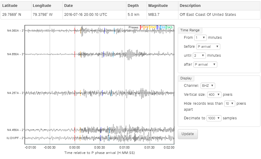
(click the image to make it yuuuge)
Those are the waveforms from the 5 nearest stations, according to the 'phases' tab under 'origin', from the USGS link you provided.
Also, if click on the waveform tab, you'll see a link to the Wilbur page associated with this event. That's where I generated the image. I just had to add the 'N4' network by clicking inside the 'networks' box; then stations 2-5 in the image above were available.
Was this what you were looking for?
edit on 7/18/2016 by Olivine because: (no reason given)
edit on 7/18/2016 by Olivine
because: spelling flub
a reply to: Olivine
Precisely. And thank you for the explanation!
I also see the other posts over in quakewatch regarding the 10,000 lb. explosive. That's a rough match for the Mw of 3.7 too. One online conversion calculator I used showed it as a bit over 5.3 ttnt, iirc.
Was this what you were looking for?
Precisely. And thank you for the explanation!
I also see the other posts over in quakewatch regarding the 10,000 lb. explosive. That's a rough match for the Mw of 3.7 too. One online conversion calculator I used showed it as a bit over 5.3 ttnt, iirc.
originally posted by: crappiekat
Seekingdepth just posted this.
www.abovetopsecret.com...
Hey, ck!
Yeah, I saw that not long after I posted this thread and felt a little silly for making as big a deal about it as I did. But hey, I learned some stuff, thanks to Olivine.
Also, what's up with the odd looking patterns in the red ovals here?
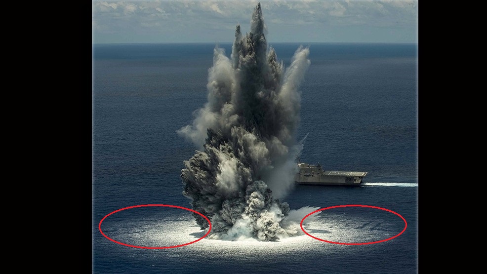
Imaging artifacts. Shadows? Is that noon local time? I'm not sure of the conversion for the time zone it's in.
Maybe something, maybe nothing.
Imaging artifacts. Shadows? Is that noon local time? I'm not sure of the conversion for the time zone it's in.
Maybe something, maybe nothing.
It's a cover up!! The NAVY just blew up a hostile (as in wants to save humanity) USO base of ET'S !!! J/K
Wow- ok. Now that we know it was an explosion, I went and pulled raw seismic data from 5 stations, and was able to generate both waveforms and spectro
of the boom:
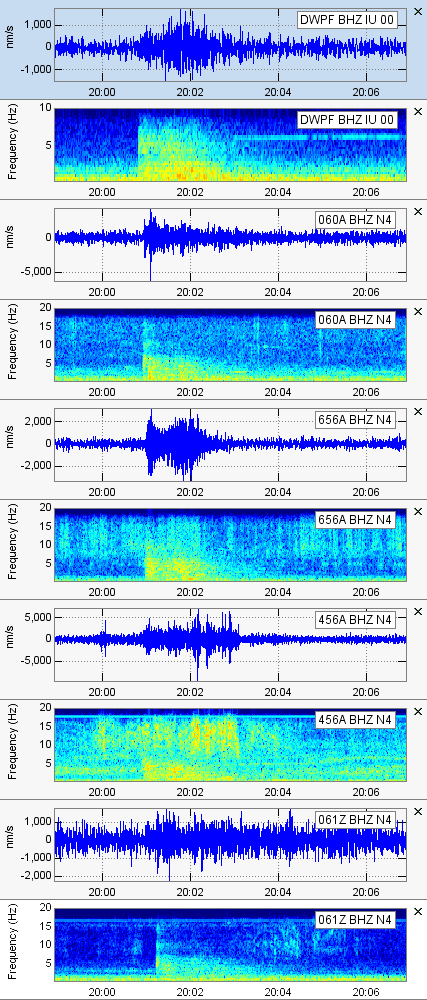
For each station, the waveform is on top with its associated spectrograph below it.
Now what gets me about this is that the USGS did not immediately report this as an explosion. You see, they are supposed to be able to tell from close analysis of the waveform data. It's kind of scary to think, actually, that a massive explosion could go off and the USGS would report it as an earthquake initially. If you look closely at the waveforms, there are differences between these and a typical earthquake. The USGS is supposed to spot these differences and recognize them. Our national security could depend on it.
USGS FAIL.
The waveform from station 656A is the clear giveaway that should have been recognized as an explosion. I know this signature from studying nuclear blast signatures. The waveform data from that last North Korea nuke test explosion looks strikingly similar, for example.
edit on Tue Jul 19th
2016 by TrueAmerican because: (no reason given)
So, it could have been nuclear?
Whatever kind of blast it was...
Get ready for dead/injured fish & dolphins
to start washing ashore soon!
WOQ
Whatever kind of blast it was...
Get ready for dead/injured fish & dolphins
to start washing ashore soon!
WOQ
originally posted by: wasobservingquietly
So, it could have been nuclear?
Whatever kind of blast it was...
Get ready for dead/injured fish & dolphins
to start washing ashore soon!
WOQ
WOO HOO!! free fertilizer!!
a reply to: jadedANDcynical
I am betting those weird linear patterns are from interaction between the pressure waves from the explosion and the surface water waves, amplifying each other in some areas, and cancelling in others.
I am betting those weird linear patterns are from interaction between the pressure waves from the explosion and the surface water waves, amplifying each other in some areas, and cancelling in others.
new topics
-
Has Tesla manipulated data logs to cover up auto pilot crash?
Automotive Discussion: 13 minutes ago -
whistleblower Captain Bill Uhouse on the Kingman UFO recovery
Aliens and UFOs: 5 hours ago -
1980s Arcade
General Chit Chat: 7 hours ago -
Deadpool and Wolverine
Movies: 8 hours ago -
Teenager makes chess history becoming the youngest challenger for the world championship crown
Other Current Events: 9 hours ago -
CIA botched its handling of sexual assault allegations, House intel report says
Breaking Alternative News: 10 hours ago
top topics
-
Lawsuit Seeks to ‘Ban the Jab’ in Florida
Diseases and Pandemics: 12 hours ago, 20 flags -
Starburst galaxy M82 - Webb Vs Hubble
Space Exploration: 14 hours ago, 13 flags -
The Superstition of Full Moons Filling Hospitals Turns Out To Be True!
Medical Issues & Conspiracies: 16 hours ago, 8 flags -
CIA botched its handling of sexual assault allegations, House intel report says
Breaking Alternative News: 10 hours ago, 8 flags -
15 Unhealthiest Sodas On The Market
Health & Wellness: 14 hours ago, 6 flags -
whistleblower Captain Bill Uhouse on the Kingman UFO recovery
Aliens and UFOs: 5 hours ago, 6 flags -
1980s Arcade
General Chit Chat: 7 hours ago, 4 flags -
Deadpool and Wolverine
Movies: 8 hours ago, 3 flags -
Teenager makes chess history becoming the youngest challenger for the world championship crown
Other Current Events: 9 hours ago, 3 flags -
Has Tesla manipulated data logs to cover up auto pilot crash?
Automotive Discussion: 13 minutes ago, 0 flags
active topics
-
"We're All Hamas" Heard at Columbia University Protests
Social Issues and Civil Unrest • 199 • : FlyersFan -
It takes One to Be; Two to Tango; Three to Create.
Philosophy and Metaphysics • 7 • : Terpene -
Take it to the Media when you protest.. Don't let them ignore you!
Education and Media • 4 • : SchrodingersRat -
They Killed Dr. Who for Good
Rant • 62 • : FlyersFan -
Has Tesla manipulated data logs to cover up auto pilot crash?
Automotive Discussion • 0 • : Cavemannick -
Lawsuit Seeks to ‘Ban the Jab’ in Florida
Diseases and Pandemics • 22 • : Disgusted123 -
Definitive 9.11 Pentagon EVIDENCE.
9/11 Conspiracies • 421 • : Lazy88 -
1980s Arcade
General Chit Chat • 8 • : F2d5thCavv2 -
What is a dream
The Gray Area • 27 • : wrayth -
Europe declares war on Russia?
World War Three • 61 • : F2d5thCavv2
14