It looks like you're using an Ad Blocker.
Please white-list or disable AboveTopSecret.com in your ad-blocking tool.
Thank you.
Some features of ATS will be disabled while you continue to use an ad-blocker.

Flooding down in Texas
page: 1share:
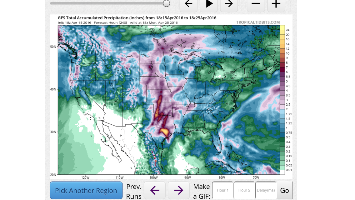
Hello everyone, I just wanted to detail and bring to your attention that Texas is expecting anywhere between 6 - 15 inches of rain over the next week,
while the GFS model touts continued rain chances for the next 16 days ahead (That's subject to a lot of variance) The bullseye seems to be south Texas
near the San antonio area where possibly 15" of rain could occur, as we get closer to the event/s the mesoscale features will become clearer and will
be able to provide more detail and pin point the projected rainfall totals here is a model depiction, showing the next 240hrs of accumulated
precipitation .
Be prepared for road closures across Texas, Also there is an attendant severe weather threat the good news is that large hail looks very unlikely, the bad news is there's a risk for tornadic thunderstorms & supercells; once again as we get closer to Sunday I'll be able to pin point where the most likely area for severe weather will occur, this is a multi day event I will update throughout here are some words from the national weather service :
And this is what Stevie Ray Vaughan has to say about it..
Be prepared for road closures across Texas, Also there is an attendant severe weather threat the good news is that large hail looks very unlikely, the bad news is there's a risk for tornadic thunderstorms & supercells; once again as we get closer to Sunday I'll be able to pin point where the most likely area for severe weather will occur, this is a multi day event I will update throughout here are some words from the national weather service :
THERE WILL BE A CHANCE OF SHOWERS AND THUNDERSTORMS AREA WIDE SATURDAY WITH THE BEST CHANCES /30-40 PERCENT POPS/ BEING WEST OF THE I-35. BY LATE AFTERNOON...A COLD FRONT WILL EXTENDED FROM SOUTHEASTERN SOUTH DAKOTA SOUTHWEST INTO SOUTHEASTERN COLORADO WHILE A DRYLINE WILL EXTEND FROM WEST TEXAS. WITH MUCAPES CLIMBING ABOVE 1000 J/KG AND 40-50 KNOTS OF EFFECTIVE BULK SHEAR SOME SUPERCELLS ARE EXPECTED TO DEVELOP ALONG THE DRYLINE. SOME OF THIS ACTIVITY IS EXPECTED TO MOVE INTO THE FORECAST AREA SATURDAY EVENING...BRINGING THE POTENTIAL OF DAMAGING WINDS AND LARGE HAIL. RAIN CHANCES WILL INCREASE AREA WIDE SATURDAY WITH THE BEST CHANCES OF RAIN /60 TO 80 PERCENT POPS/ NORTHWEST OF A GOLDTHWAITE TO GAINESVILLE LINE. RAIN CHANCES WILL TAPER OFF TO 20 PERCENT ACROSS THE EASTERN QUARTER OF THE FORECAST AREA. THERE WILL BE THE POTENTIAL FOR SOME HEAVY RAIN SATURDAY NIGHT ACROSS THE WEST AS PWATS REACH 1.5 INCHES WHICH IS NEARLY +2 STANDARD DEVIATIONS. WE WILL CONSIDER ISSUING A FLASH FLOOD WATCH FOR OUR FORECAST AREA WITH THE SATURDAY MORNING PACKAGE. WIDESPREAD SHOWERS AND THUNDERSTORMS ARE EXPECTED SUNDAY THROUGH MONDAY. VERY HEAVY RAIN IS EXPECTED ALONG WITH THE POTENTIAL FOR SEVERE WEATHER DURING THIS PERIOD. THERE WILL BE A THREAT FOR TORNADOES ACROSS PARTS OF CENTRAL TEXAS SUNDAY AFTERNOON AND EVENING. CHANCES OF SHOWERS AND THUNDERSTORMS WILL CONTINUE TUESDAY THROUGH THURSDAY WITH ABOVE SEASONAL NORMAL LOW TEMPERATURES AND NEAR TO SLIGHTLY ABOVE NORMAL HIGHS.
And this is what Stevie Ray Vaughan has to say about it..
edit on 15-4-2016 by TechniXcality because: (no reason given)
Yes, the weather in KC next week looks like solid rain. The only saving grace is that our ground is not saturated so hopefully our basement doesn't
start seeping like it did last year.
a reply to: TechniXcality
Hopefully you guys get nothing more than your hats wet!
And as for Stevie:
Hopefully you guys get nothing more than your hats wet!
And as for Stevie:
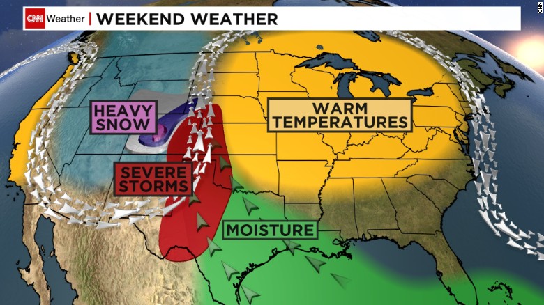
Omega Block setup
Here's how it works: an area of high pressure aloft will develop and anchor itself near the Great Lakes. This high will be sandwiched between two southward dips in the jet stream, one over the western Atlantic Ocean, and the other over the western United States.
In the Plains, heavy rain and severe thunderstorms will be the result of this weather pattern starting Friday.
The omega high over the Great Lakes will block the forward progression of an area of low pressure that forecast to form in the upper atmosphere over the western states. That low will interact with moisture returning north from the Gulf of Mexico, leading to the development of widespread rain and thunderstorms in the Plains.
a reply to: roadgravel
Yeah... first time I've heard of that term, but here's a CNN link for the info:
edition.cnn.com...
Yeah... first time I've heard of that term, but here's a CNN link for the info:
edition.cnn.com...
I like simple pictures:
The name 'Omega Block' suits very well if you know the omega symbol.
The name 'Omega Block' suits very well if you know the omega symbol.
I hope everyone fares well during the storm and stays safe.
You might be stuck inside for a while so make sure your beer supply is well stocked.
You might be stuck inside for a while so make sure your beer supply is well stocked.
That's going to be right on top of me.
I have to work outside rain or shine.
Should be fun.
I have to work outside rain or shine.
Should be fun.
a reply to: roadgravel
Thanks for that info. I heard it would stall over nort central TX. Guess South TX will be swimming again
Thanks for that info. I heard it would stall over nort central TX. Guess South TX will be swimming again
a reply to: liveandlearn
NOAA - SA - Austin
Sounds as though I'm getting wet soon although it looks to be predicted heavier a bit farther north.
NOAA - SA - Austin
The greatest threat for heavy rainfall and flash flooding will be along and east of I-35 from San Antonio to Austin. The timing of this threat will be Sunday morning through Monday evening.
Sounds as though I'm getting wet soon although it looks to be predicted heavier a bit farther north.
edit on 4/15/2016 by roadgravel because:
(no reason given)
I'm just south of San Antonio..last time if flooded in my little town,I had a foot of water in my house. Insurance company hosed me too. Not looking
forward to the rain.
Thanks Tex for your great threads & keeping us informed. Here's hoping we all are intact and dry when it's all over. Stay safe everyone!
originally posted by: skunkape23
That's going to be right on top of me.
I have to work outside rain or shine.
Should be fun.
Fun , not my idea. But each to his own
Just stay safe.
Doesn't Texas need the rain though? I thought the state is still under a long term drought
originally posted by: Philippines
Doesn't Texas need the rain though? I thought the state is still under a long term drought
Not on the South Coast. The rain levels have been good. Not too hot, not too cold.
Just a month ago, heavy rains shut down I-10 between Tx and La.
We've had our fair share of rain in central Texas. My area forecast is rain all week (7 days) up 8-10 inches Sunday alone.
mg
We've had our fair share of rain in central Texas. My area forecast is rain all week (7 days) up 8-10 inches Sunday alone.
mg
a reply to: TechniXcality
Waiting for that storm to blow down here in Austin. If it comes to it, I'll meet you half way with a case of beer in my flat bottom boat.
ETA: However, you should post it with this pic There is an awesome one from last year but I can't seem to find it.
i.imgur.com...
Waiting for that storm to blow down here in Austin. If it comes to it, I'll meet you half way with a case of beer in my flat bottom boat.
ETA: However, you should post it with this pic There is an awesome one from last year but I can't seem to find it.
i.imgur.com...
edit on 16-4-2016 by StallionDuck because: added vid
new topics
-
whistleblower Captain Bill Uhouse on the Kingman UFO recovery
Aliens and UFOs: 2 hours ago -
1980s Arcade
General Chit Chat: 4 hours ago -
Deadpool and Wolverine
Movies: 5 hours ago -
Teenager makes chess history becoming the youngest challenger for the world championship crown
Other Current Events: 6 hours ago -
CIA botched its handling of sexual assault allegations, House intel report says
Breaking Alternative News: 7 hours ago -
Lawsuit Seeks to ‘Ban the Jab’ in Florida
Diseases and Pandemics: 10 hours ago
top topics
-
Lawsuit Seeks to ‘Ban the Jab’ in Florida
Diseases and Pandemics: 10 hours ago, 20 flags -
Starburst galaxy M82 - Webb Vs Hubble
Space Exploration: 12 hours ago, 11 flags -
CIA botched its handling of sexual assault allegations, House intel report says
Breaking Alternative News: 7 hours ago, 8 flags -
The Superstition of Full Moons Filling Hospitals Turns Out To Be True!
Medical Issues & Conspiracies: 13 hours ago, 8 flags -
IDF Intel Chief Resigns Over Hamas attack
Middle East Issues: 17 hours ago, 6 flags -
whistleblower Captain Bill Uhouse on the Kingman UFO recovery
Aliens and UFOs: 2 hours ago, 6 flags -
15 Unhealthiest Sodas On The Market
Health & Wellness: 12 hours ago, 5 flags -
Teenager makes chess history becoming the youngest challenger for the world championship crown
Other Current Events: 6 hours ago, 3 flags -
Deadpool and Wolverine
Movies: 5 hours ago, 3 flags -
1980s Arcade
General Chit Chat: 4 hours ago, 3 flags
active topics
-
1980s Arcade
General Chit Chat • 7 • : Freeborn -
How ageing is" immune deficiency"
Medical Issues & Conspiracies • 24 • : annonentity -
Europe declares war on Russia?
World War Three • 59 • : Freeborn -
George Knapp AMA on DI
Area 51 and other Facilities • 38 • : theshadowknows -
Candidate TRUMP Now Has Crazy Judge JUAN MERCHAN After Him - The Stormy Daniels Hush-Money Case.
Political Conspiracies • 618 • : WeMustCare -
New whistleblower Jason Sands speaks on Twitter Spaces last night.
Aliens and UFOs • 38 • : baablacksheep1 -
-@TH3WH17ERABB17- -Q- ---TIME TO SHOW THE WORLD--- -Part- --44--
Dissecting Disinformation • 605 • : Ektar -
Teenager makes chess history becoming the youngest challenger for the world championship crown
Other Current Events • 3 • : Skinnerbot -
So you don't believe in the devil
Paranormal Studies • 143 • : burritocat -
whistleblower Captain Bill Uhouse on the Kingman UFO recovery
Aliens and UFOs • 5 • : budzprime69