It looks like you're using an Ad Blocker.
Please white-list or disable AboveTopSecret.com in your ad-blocking tool.
Thank you.
Some features of ATS will be disabled while you continue to use an ad-blocker.

Advanced Watch Wednesday : Texas severe weather outbreak
page: 1share:
As an avid weather watcher, and meteorologist in a past life, I wanted to discuss the potential that exists for a Tornado/Severe weather outbreak
Wednesday evening, as we get closer to the event we will be able to pin point the finer details but i wanted to make all aware specially after the
damaging hail storms that came through last week, that an event of the same scale or worse could occur in the north central Texas area
currently forecast around 6pm Wednesday, Here are a few model depictions:
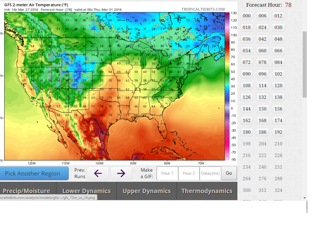
This map is showing temperatures nearing 80 degrees across north Texas helping to prime the atmosphere with instability
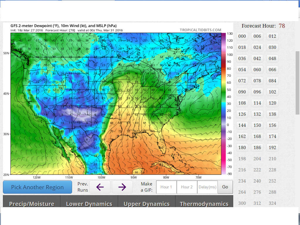
This map (an important one) depicts dew points nearing 70 degrees with a well defined dry line (dew points in the 40s and lower highlighted in green and blue) west of north central Texas which would be the focal point of rapid storm development.
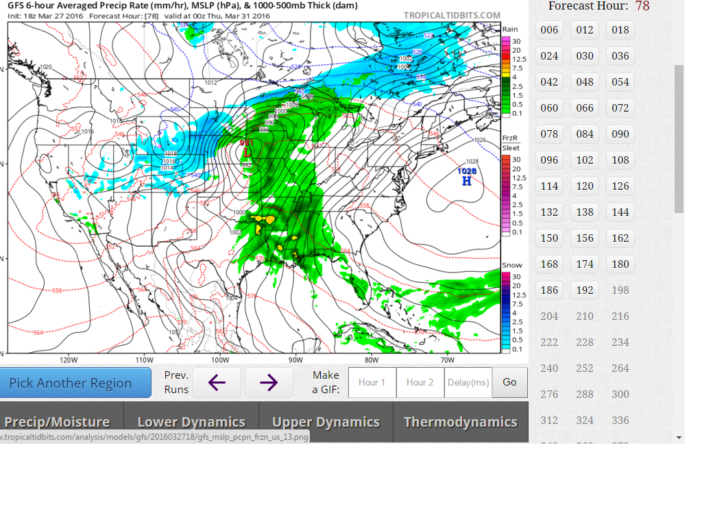
This map is a low resolution picture of convection at 6pm, which will be refined as we get closer to the event
I say all that to say this, even though meteorologists on T.V may not be discussing the severe potential at this time (because things can change alot over three days) the potential exists for north central Texas to experience a significant severe weather outbreak, with all modes of weather possible including long track tornadoes.
here is a word in regard to Wednesday from the National Weather Service ( link ) :
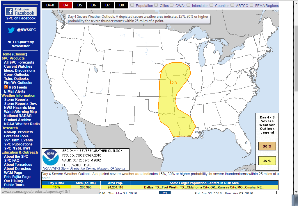
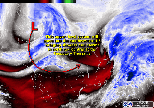
Here is what the storm prediction center is highlighting for severe weather, (so obviously it is not just north Texas that needs to stay tuned, however north Texas is in an very favorable spot for severe weather on Wednesday)
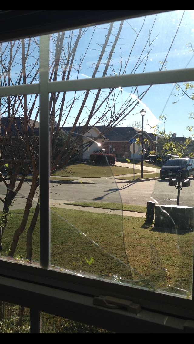
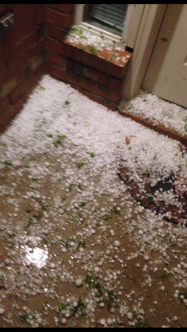
And just to give an example of how destructive storms can be with even less instability and favorable set up for severe weather, I am having to repair my window & fence because of quarter sized hail that came through last week with 60mph winds.
and as always if you wish to watch the storm chaser live stream here is a LINK
Everyone stay safe and stay tuned and check in thanks
This map is showing temperatures nearing 80 degrees across north Texas helping to prime the atmosphere with instability
This map (an important one) depicts dew points nearing 70 degrees with a well defined dry line (dew points in the 40s and lower highlighted in green and blue) west of north central Texas which would be the focal point of rapid storm development.
This map is a low resolution picture of convection at 6pm, which will be refined as we get closer to the event
I say all that to say this, even though meteorologists on T.V may not be discussing the severe potential at this time (because things can change alot over three days) the potential exists for north central Texas to experience a significant severe weather outbreak, with all modes of weather possible including long track tornadoes.
here is a word in regard to Wednesday from the National Weather Service ( link ) :
THE UPPER LOW OVER THE ROCKIES WILL OPEN UP AND LIFT OVER THE CENTRAL HIGH PLAINS ON WEDNESDAY...PUSHING THE WAA SECTOR OF CONVECTION ACROSS OUR EASTERN COUNTIES WITH A SURFACE DRYLINE MOVING EAST INTO AREAS WEST OF I-35 BY AFTERNOON. THE COMBINATION OF THE LEFT EXIT REGION OF A 130 KT UPPER JET MAXIMUM WITH HIGHS PUSHING 80 DEGREES AND INSTABILITY OVER 2000 J/KG...LIKELY MEANS RAPIDLY DEVELOPING STRONG TO SEVERE STORMS WEDNESDAY AFTERNOON ACROSS ABOUT THE EASTERN HALF TO TWO THIRDS OF THE AREA. DEEP LAYER SHEAR WILL BE 30-40KTS... THUS A MULTI-CELLULAR OR BROKEN SQUALL LINE/QLCS MODE SEEMS PLAUSIBLE WITH POSSIBLE SUPERCELLS OUT WELL AHEAD OF THE DRYLINE FROM EARLY AFTERNOON THROUGH THE EVENING HOURS ACROSS THE FAR EASTERN COUNTIES WEDNESDAY NIGHT. ALL MODES OF SEVERE WOULD BE POSSIBLE...SO BEST TO PRACTICE YOUR SEVERE WEATHER SAFETY PLANS NOW.
Here is what the storm prediction center is highlighting for severe weather, (so obviously it is not just north Texas that needs to stay tuned, however north Texas is in an very favorable spot for severe weather on Wednesday)
And just to give an example of how destructive storms can be with even less instability and favorable set up for severe weather, I am having to repair my window & fence because of quarter sized hail that came through last week with 60mph winds.
and as always if you wish to watch the storm chaser live stream here is a LINK
Everyone stay safe and stay tuned and check in thanks
a reply to: TechniXcality
I wouldnt get worried too much. I'm in Arizona. When the weather gets nasty and WINDY here, I know you fellas in Texas are gonna feel it. I send out an advisory. New Mexico weather just goes over them. Consider my warnings as insurance when tornado activity picks up.
Kratos
I wouldnt get worried too much. I'm in Arizona. When the weather gets nasty and WINDY here, I know you fellas in Texas are gonna feel it. I send out an advisory. New Mexico weather just goes over them. Consider my warnings as insurance when tornado activity picks up.
Kratos
a reply to: TechniXcality
Thank you handsome Texan!
(you know that's my pet name for you! LOL)
I really appreciate your early warnings as often is the case when Texas sees bad weather we are not far behind.
On occasion, especially in the Spring, the severe weather events travel straight up through Mississippi and Alabama and swing up through Memphis and on...
Sometimes, if a front is pushing hard enough downward from the North it can keep it to our South but then our Southerly neighbors are in for it. The storms are able to build and grow more severe.
I am up on a mountain, of sorts, and storms can easily fizzle out and we say "It couldn't make it up the West side of the mountain" but when they do...make...they are usually doozies. THAT'S a very technical meteorological term!
They have pretty much had us on "alert" for Wednesday here in Arkansas too.
Thanks for the heads up... our local folks are not very dependable lately.
Glad to know you are watching over us!!!
Keep up the good work... you are appreciated
Thanks for the heads up... our local folks are not very dependable lately.
Glad to know you are watching over us!!!
Keep up the good work... you are appreciated
a reply to: TNMockingbird
I often only highlight Texas because the amount of time involved and also that I live in this area but if asked I will look into other areas. So I do apologize for not covering everything but you can ask me anytime and I will look into it. Thank you so much for your kind words and honestly I have to say you are one of the sweetest if not the sweetest member here, so if anyone messes with you, let me know . Anyway, hope you are having a very happy Easter and may the fertility God/ess make everyone fruitful and multiplying,I'm kidding.. Happy Easter y'all
I often only highlight Texas because the amount of time involved and also that I live in this area but if asked I will look into other areas. So I do apologize for not covering everything but you can ask me anytime and I will look into it. Thank you so much for your kind words and honestly I have to say you are one of the sweetest if not the sweetest member here, so if anyone messes with you, let me know . Anyway, hope you are having a very happy Easter and may the fertility God/ess make everyone fruitful and multiplying,I'm kidding.. Happy Easter y'all
a reply to: TechniXcality
Thanks for the headsup ever since you posted about the storms a month or 2 ago I've been watching the stormchasers on TVNwether whenever they're online, will make a note to pay more attention Wednesday!
Thanks for the headsup ever since you posted about the storms a month or 2 ago I've been watching the stormchasers on TVNwether whenever they're online, will make a note to pay more attention Wednesday!
Stay safe people, the wrath of mother nature is never a good thing to go through.
I don't know, in my area (north Plano) the sirens are going off about every 3rd week. It's getting to the point I don't bother to jump in the
downstairs bathroom unless I get other indications like sideways rain or hail.
Last week there was sirens and it yelled "severe thunderstorm warning". You kidding me!? That's for the nados. I don't need get excited over some thunderstorm.
I get that we're having more freakish weather more frequently, and this coincides with having more data to geek out at than ever, but I think some are taking this a little too far.
edit on 27-3-2016 by pl3bscheese because: (no reason given)
Things are heating up in Western Ky tonight. There's reports of multiple homes damaged and a barn destroyed in Muhlenburg County, KY. They just
extended a tornado warning in the area until 9:30 EST. Hope everyone is staying safe tonight the best they can!
edit on 3/27/2016 by EternalSolace because: (no reason given)
a reply to: pl3bscheese
While I understand your jadedness, last week was damaging for me in Wylie and for many others; severe weather can be forecast ahead of time but the pin point locations are still blurry & mesoscale features, however our technology is improving as well as advanced warning.
A severe thunderstorm warning is not for tornadoes, a tornado warning is for tornadoes.. Typically a severe thunderstorm warning indicates that within the county winds above 50mph and hail larger than pennies is occurring.This last year has been very active for the north central Texas area and of course the tornadoes and deaths that occurred during December still have many weary.
By posting these threads I hope to raise awareness and safety (if possible) and of course enjoy the cool aspects of weather together, and also I try to only post when there is model consensus and a clear threat as to not engage in hyperbole. Once again I do understand your complacency but please don't ignore warnings, just because in the past your house specifically was not damaged or in the path of the most severe part of the thunderstorm.
edit on 27-3-2016 by TechniXcality because: (no reason given)
originally posted by: TechniXcality
a reply to: pl3bscheese
While I understand your jadedness, last week was damaging for me in Wylie and for many others; severe weather can be forecast ahead of time but the pin point locations are still blurry & mesoscale features, however our technology is improving as well as advanced warning.
I'm not jaded! You'd see a whole new level of wickedness if I was jaded
A severe thunderstorm warning is not for tornadoes, a tornado warning is for tornadoes.. Typically a severe thunderstorm warning indicates that within the county winds above 50mph and hail larger than pennies is occurring.This last year has been very active for the north central Texas area and of course the tornadoes and deaths that occurred during December still have many weary.
I've never before heard the sirens used for a severe thunderstorm. Those sirens are for tornadoes. I guess if people were outside walking at 11pm when it happened it would have been useful, but for most everyone else inside the comfort of their homes they were freaked out and possibly awoken to the thought of a tornado spotted or possibly forming near them.
By posting these threads I hope to raise awareness and safety (if possible) and of course enjoy the cool aspects of weather together, and also I try to only post when there is model consensus and a clear threat as to not engage in hyperbole. Once again I do understand your complacency but please don't ignore warnings, just because in the past your house specifically was not damaged or in the path of the most severe part of the thunderstorm.
I don't get it. There's a siren tripping out at me, and that's supposed to protect my home? How did you knowing the severe thunderstorm was coming protect your window? I'm pretty sure everyone is aware that severe thunderstorms happen periodically.
It's totally cool, I get that this is your thing and you're into it. Nothing wrong with geeking out to things that excite you. I think it's my genetics. My brother is a professional skydiver. I don't tend to freak out when other people perceive chaotic events. It pretty well provides a calm for me to focus and assess what needs be done. I'm the kind of guy that breaks up bar fights, or leaps out into risky situations to prevent catastrophes, but not at all a fireman type all the same. No worries, to each their own.
a reply to: TechniXcality
Thank you once again. Much better update than my local channels. This spring with the last two forecasts for minimal bad weather the hail is equaling what we had in the early to mid 1990's. My daughter got hit 3 times and she was in 3 different areas of the metroplex at the time she got hit.
Will be following for sure. You, for me, are the best ATS weather forcaster.
a reply to: TechniXcality
Thanks for the heads-up. I live in Texas, not far from San Antonio, (far as in Texas terms).
What I honestly don't understand about "weather" is how come it is that the TV meteorologists in San Antonio are so "weak"? In Houston, meteorology is easy, everything is all about the Gulf. But for some odd reason, pros just can't forecast the weather in south west Texas.
Do you know or can you telll me why that is?
Quick up date
from SPC
Wednesday continues to look like a favorable set up for a severe weather outbreak across the deep south into the mid west, I will continue to update thanks stay safe yall
from SPC
RICH GULF MOISTURE WITH UPPER 60S TO NEAR 70 F DEWPOINTS WILL ADVECT NWD THROUGH THE WARM SECTOR IN ADVANCE OF A PROGRESSIVE UPPER JET MAXIMUM. CURRENT INDICATIONS ARE THAT AT LEAST SOME STORMS WILL DEVELOP EARLY WITHIN THE WARM ADVECTION REGIME AHEAD OF THIS FEATURE AND LOWERS CONFIDENCE WHERE THE BEST DESTABILIZATION WILL EVOLVE COINCIDENT WITH STRENGTHENING DEEP LAYER WINDS. GIVEN THE RICH LOW-LEVEL MOISTURE AND FAVORABLE LOW-LEVEL HODOGRAPHS...A THREAT WILL EXIST FOR SOME STORMS TO INTENSIFY AND DEVELOP SUPERCELL STRUCTURES FROM ERN TX AND SPREADING INTO THE LOWER MS VALLEY. THREAT WILL EXIST FOR A FEW TORNADOES...DAMAGING WIND AND HAIL. THIS AREA WILL CONTINUE TO BE MONITORED FOR POSSIBLE HIGHER PROBABILITIES IN LATER OUTLOOKS...BUT UNCERTAINTY REGARDING EXTENT OF EARLY CONVECTION LOWERS CONFIDENCE IN MORE THAN A SLIGHT RISK AREA AT THIS TIME.
Wednesday continues to look like a favorable set up for a severe weather outbreak across the deep south into the mid west, I will continue to update thanks stay safe yall
a reply to: TonyS
Hey Tony,
Forecasting Texas weather in general can be a pain because of the location of our state and the many features interacting. I cannot say for sure why your experience is this way, but i can say meteorologists often take a conservative approach to forecasting or "whats in the best interests of our viewers" which can lead to busted forecasts, or they can take a wildly hyperbolic approach, this usually occurs when a very favorable set up for severe weather is being hinted at by the models with little inhibition, however this too can bust because of any number of mesoscale features that were not accurately modeled. If you'd like a better place to get your information tryHERE and just click on your city/county. Hope this helps answer your question alittle- but honestly by (me) making a severe weather call 3 days in advance I too am risking the sock in the mouth, don't get me wrong there is no doubt severe weather will occur in the deep south and Midwest Wednesday, pin pointing exactly where is the challenge and I am fairly confident Dallas Tx is in for a doozy. Have a good day
edit on 28-3-2016 by TechniXcality because: (no
reason given)
NWS:
WEDNESDAY IS STILL SHAPING UP TO BE A VERY ACTIVE DAY FOR THUNDERSTORMS ACROSS NORTH AND CENTRAL TEXAS DUE TO ABUNDANT LOW LEVEL MOISTURE...STEEP MID LEVEL LAPSE RATES AND INCREASING LARGE SCALE LIFT GENERATED BY A 150 KNOT JET ORIENTED FROM NORTHERN MEXICO TO SOUTHEAST TEXAS. TWO MODES OF CONVECTION ARE LIKELY ON WEDNESDAY WITH THE FIRST BEING ORGANIZED STORMS ON AN EASTWARD MOVING DRYLINE AND THE SECOND BEING MORE DISCRETE STORMS OR MULTICELL CLUSTERS IN THE WARM SECTOR. THE ONLY LIMITING FACTOR TO DISCRETE SUPERCELLS IN THE WARM SECTOR WILL BE EXTENSIVE CLOUD COVER EXPECTED DURING THE AFTERNOON. ALTHOUGH THUNDERSTORMS WILL BE POSSIBLE THROUGH THE DAY WEDNESDAY...THE AFTERNOON/EARLY EVENING WILL BE THE MOST LIKELY TIME FOR SEVERE THUNDERSTORMS... ESPECIALLY SINCE THE DRYLINE WILL MOST LIKELY NOT ENTER WESTERN NORTH TEXAS UNTIL LATE AFTERNOON.
a reply to: TechniXcality
Any idea of times ? Last 2 days has been pretty crappy for exciting weather watching
Any idea of times ? Last 2 days has been pretty crappy for exciting weather watching
new topics
-
Maestro Benedetto
Literature: 25 minutes ago -
Is AI Better Than the Hollywood Elite?
Movies: 34 minutes ago -
Las Vegas UFO Spotting Teen Traumatized by Demon Creature in Backyard
Aliens and UFOs: 4 hours ago -
2024 Pigeon Forge Rod Run - On the Strip (Video made for you)
Automotive Discussion: 4 hours ago -
Gaza Terrorists Attack US Humanitarian Pier During Construction
Middle East Issues: 5 hours ago -
The functionality of boldening and italics is clunky and no post char limit warning?
ATS Freshman's Forum: 6 hours ago -
Meadows, Giuliani Among 11 Indicted in Arizona in Latest 2020 Election Subversion Case
Mainstream News: 6 hours ago -
Massachusetts Drag Queen Leads Young Kids in Free Palestine Chant
Social Issues and Civil Unrest: 7 hours ago -
Weinstein's conviction overturned
Mainstream News: 8 hours ago -
Supreme Court Oral Arguments 4.25.2024 - Are PRESIDENTS IMMUNE From Later Being Prosecuted.
Above Politics: 10 hours ago
top topics
-
Krystalnacht on today's most elite Universities?
Social Issues and Civil Unrest: 10 hours ago, 9 flags -
Supreme Court Oral Arguments 4.25.2024 - Are PRESIDENTS IMMUNE From Later Being Prosecuted.
Above Politics: 10 hours ago, 8 flags -
Weinstein's conviction overturned
Mainstream News: 8 hours ago, 7 flags -
Gaza Terrorists Attack US Humanitarian Pier During Construction
Middle East Issues: 5 hours ago, 7 flags -
University of Texas Instantly Shuts Down Anti Israel Protests
Education and Media: 12 hours ago, 6 flags -
Massachusetts Drag Queen Leads Young Kids in Free Palestine Chant
Social Issues and Civil Unrest: 7 hours ago, 6 flags -
Meadows, Giuliani Among 11 Indicted in Arizona in Latest 2020 Election Subversion Case
Mainstream News: 6 hours ago, 5 flags -
Las Vegas UFO Spotting Teen Traumatized by Demon Creature in Backyard
Aliens and UFOs: 4 hours ago, 3 flags -
2024 Pigeon Forge Rod Run - On the Strip (Video made for you)
Automotive Discussion: 4 hours ago, 2 flags -
Any one suspicious of fever promotions events, major investor Goldman Sachs card only.
The Gray Area: 14 hours ago, 2 flags
active topics
-
My Poor Avocado Plant.
General Chit Chat • 77 • : JonnyC555 -
University of Texas Instantly Shuts Down Anti Israel Protests
Education and Media • 219 • : marg6043 -
New whistleblower Jason Sands speaks on Twitter Spaces last night.
Aliens and UFOs • 61 • : Ophiuchus1 -
Is AI Better Than the Hollywood Elite?
Movies • 2 • : 5thHead -
Gaza Terrorists Attack US Humanitarian Pier During Construction
Middle East Issues • 25 • : CarlLaFong -
VP's Secret Service agent brawls with other agents at Andrews
Mainstream News • 57 • : Guyfriday -
Mood Music Part VI
Music • 3102 • : Hellmutt -
Las Vegas UFO Spotting Teen Traumatized by Demon Creature in Backyard
Aliens and UFOs • 9 • : Ophiuchus1 -
British TV Presenter Refuses To Use Guest's Preferred Pronouns
Education and Media • 164 • : Annee -
Maestro Benedetto
Literature • 0 • : BrotherKinsMan