It looks like you're using an Ad Blocker.
Please white-list or disable AboveTopSecret.com in your ad-blocking tool.
Thank you.
Some features of ATS will be disabled while you continue to use an ad-blocker.

* SEVERE WEATHER ALERT * - Dangerous Situation Unfolding in the South - Feb. 23, 2016
page: 2share:
Ok reported tornados now, two of them one in New Orleans and the other in Baton rouge.
edit on 23-2-2016 by marg6043 because: (no reason
given)
Baton rouge tornado left no casualties the other one is no been talk about it, MS have one casualty due to damaging winds.
They issued a PDS alert for Alabama, something they rarely do. It's for large, intense and long-track tornadoes. Yikes, that sounds ominous.
Be safe!
Be safe!
Checking in from Mobile, AL. Guess I'll be playing home insurance roulette tonight!
I'm posting the TVN link again,
for those who want to watch these storms live...
I get stuck there sometimes lol
The chat provides good updates.
Reports of more tornadoes and extensive damage continue...
tvnweather.com...
for those who want to watch these storms live...
I get stuck there sometimes lol
The chat provides good updates.
Reports of more tornadoes and extensive damage continue...
tvnweather.com...
edit on 23-2-2016 by iunlimited491 because: (no reason given)
a reply to: hillbilly4rent
I'm right on the path, here in southern GA. the last time a tornado hit my area close enough to take some of the roof tiles away was back in 94 when the flooding was soo bad that coffins were floating down the road.
I was in CA at that time
I'm right on the path, here in southern GA. the last time a tornado hit my area close enough to take some of the roof tiles away was back in 94 when the flooding was soo bad that coffins were floating down the road.
I was in CA at that time
Assumption Parish was the other place with a tornado, they have a lot of damage.
Car tossed into field in Lamar County, Miss., during possible tornado
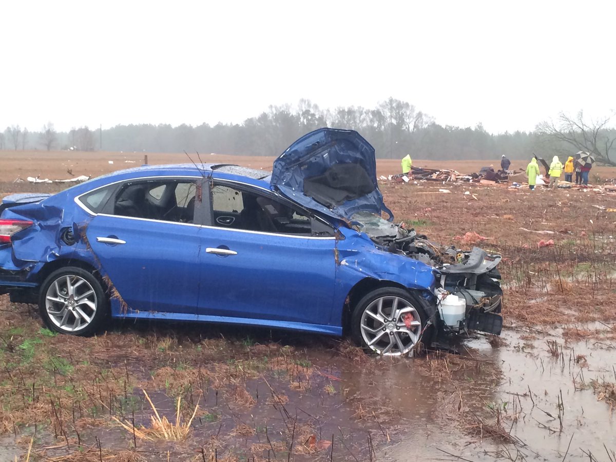 twitter.com...
Convent, La., trailer court severely damaged in possible tornado
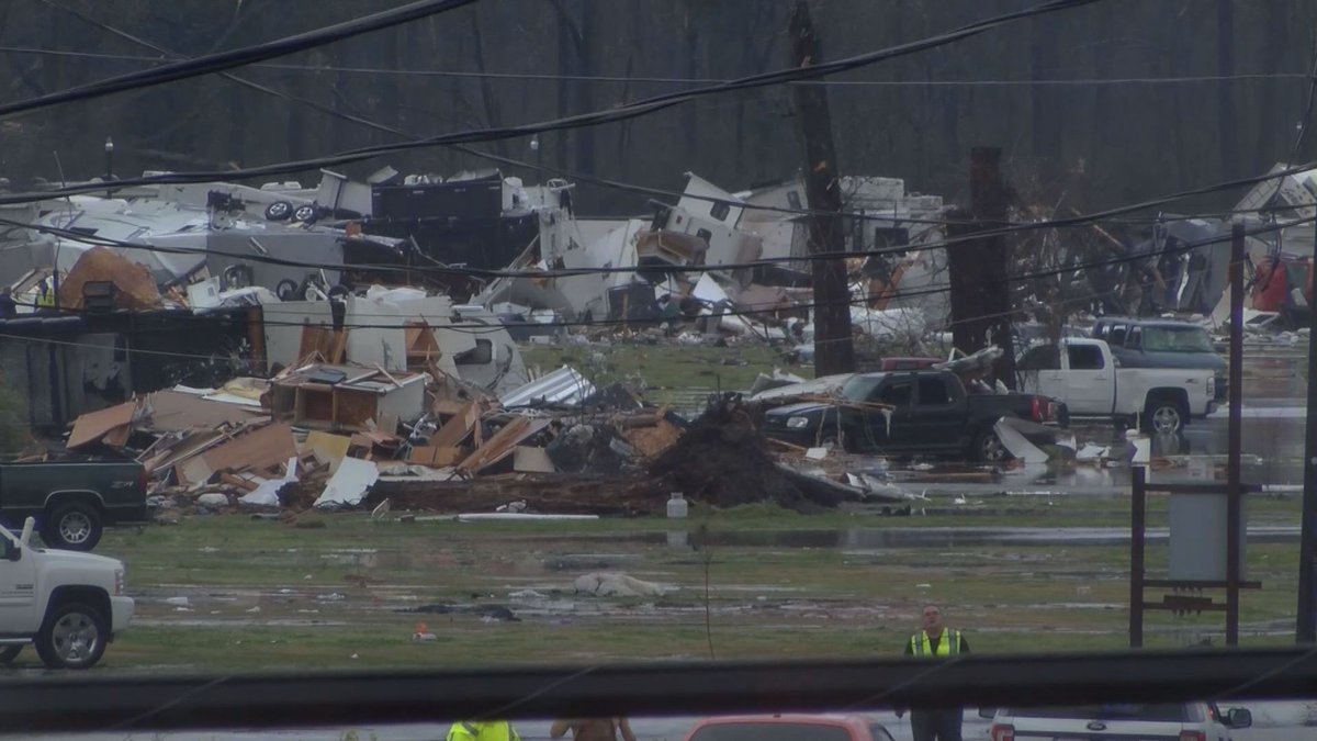 twitter.com...
Convent, La., trailer court severely damaged in possible tornado
a reply to: hillbilly4rent
Is typical of el nino year.
Well the news have changed for my area, the bad weather is to arrive here by 8 in the morning now, my husband is to stay at home from work until the weather gets better.
No schools in the morning.
Is typical of el nino year.
Well the news have changed for my area, the bad weather is to arrive here by 8 in the morning now, my husband is to stay at home from work until the weather gets better.
No schools in the morning.
Those living in the Pensacola, Fl area take shelter. There is a large tornadic cell coming ashore that the National Weather Service says is a large
and dangerous tornado!
edit on 23-2-2016 by texasgirl because: Spelling
edit on 23-2-2016 by texasgirl because: (no reason
given)
Tornado Warning
alerts.weather.gov...
...A TORNADO WARNING REMAINS IN EFFECT UNTIL 815 PM CST FOR
SOUTHEASTERN BALDWIN AND SOUTH CENTRAL ESCAMBIA COUNTIES...
AT 743 PM CST...A LARGE AND EXTREMELY DANGEROUS TORNADO WAS LOCATED
NEAR PERDIDO BEACH...OR NEAR ORANGE BEACH...MOVING NORTHEAST AT 40 MPH.
THIS IS A PARTICULARLY DANGEROUS SITUATION.
HAZARD...DAMAGING TORNADO.
SOURCIS POSSIBLE.
THE TORNADO WILL BE NEAR...
JOHNSONS BEACH AROUND 750 PM CST.
LILLIAN AROUND 755 PM CST.
MYRTLE GROVE AND WARRINGTON AROUND 805 PM CST.
WESTARNING REMAINS IN EFFECT UNTIL 815 PM CST FOR
SOUTHEASTERN BALDWIN AND SOUTH CENTRAL ESCAMBIA COUNTIES... PENSACOLA AND BELLVIEW AROUND 810 PM CST.
BRENT...GOULDING...PENSACOLA INTERNATIONAL AIRPORT...FERRY PASS AND
ENSLEY AROUND 815 PM CST.
TORNADO...RADAR IN
...A TORNADO WE...RADAR INDICATED ROTATION.
IMPACT...YOU ARE IN A LIFE THREATENING SITUATION. FLYING DEBRIS MAY
BE DEADLY TO THOSE CAUGHT WITHOUT SHELTER. MOBILE HOMES
WILL BE DESTROYED. CONSIDERABLE DAMAGE TO HOMES...
BUSINESSES...AND VEHICLES IS LIKELY AND COMPLETE DESTRUCTION
AT 743 PM CST...A LARGE AND EXTREMELY DANGEROUS TORNADO WAS LOCATED
NEAR PERDIDO BEACH...OR NEAR ORANGE BEACH...MOVING NORTHEAST AT 40 MPH.
THIS IS A PARTICULARLY DANGEROUS SITUATION.
HAZARD...DAMAGING TORNADO.
SOURCE...RADAR INDICATED ROTATION.
IMPACT...YOU ARE IN A LIFE THREATENING SITUATION. FLYING DEBRIS MAY
BE DEADLY TO THOSE CAUGHT WITHOUT SHELTER. MOBILE HOMES
WILL BE DESTROYED. CONSIDERABLE DAMAGE TO HOMES...
BUSINESSES...AND VEHICLES IS LIKELY AND COMPLETE DESTRUCTION
IS POSSIBLE.
THE TORNADO WILL BE NEAR...
JOHNSONS BEACH AROUND 750 PM CST.
LILLIAN AROUND 755 PM CST.
MYRTLE GROVE AND WARRINGTON AROUND 805 PM CST.
WEST PENSACOLA AND BELLVIEW AROUND 810 PM CST.
BRENT...GOULDING...PENSACOLA INTERNATIONAL AIRPORT...FERRY PASS AND
ENSLEY AROUND 815 PM CST.
TORNADO...RADAR INDICATED
TORNADO DAMAGE THREAT...CONSIDERABLE
HAIL...1.00IN
alerts.weather.gov...
Ok WOW! Now you gots my attention!
From SC:
Horry Co Schools (inc Myrtle Bch);
WMBF news
Georgetown Co. Schools; = closed Tomorrow
Florence Co Schools , District 2 (Pamplico btwn Florence and Conway) early release at 11:30am
WMBF news feed twitter
When I first saw this coming over the #SCWX twitter feed I thought it was some kid's idea of a prank, so I chased the link down and it was a legit news feed; I even sourced out the district's facebook pages. I don't think I have ever seen where they've closed schools before a storm other than winter or hurricanes! Somebody correct me if I'm wrong! Pls!
I've now gone from defcon 5 (ok expect some wind) to defcon 3 yeller alert; bugout bag ready; plans A,b,c, and oh Shyt at the ready! (cuz I live in a trailer surrounded by lotsa trees - ya -%$#@ - hoo, we're having fun now ain't we!)
Stay safe ya'll! see ya on the flip side.
From SC:
Horry Co Schools (inc Myrtle Bch);
Source:school district facebook pg
In an abundance of caution, Horry County Schools will be closed on Wednesday, February 24 in anticipation of severe inclement weather with high wind advisories with gusts extending from 10 a.m. until 8 p.m. All after-school activities and events are cancelled for Wednesday. The closure applies to all students and employees.
WMBF news
Georgetown Co. Schools; = closed Tomorrow
Source: Georgetown School District Facebook pg
*** No School In Georgetown County School District for Wednesday, February 24 *** Due to the severe weather threat issued by the National Weather Service of sustained high winds and damaging gusts, potential tornados and large hail on Wednesday, February 24, Georgetown County School District will be closed for students and all employees. All after-school activities are cancelled or postponed.
Florence Co Schools , District 2 (Pamplico btwn Florence and Conway) early release at 11:30am
Source: website school
Due to the anticipated inclement weather, Florence County School District Two will operate on a half day schedule on Wednesday, February 24, 2016, with schools dismissing at 11:30 a.m. All after-school activities are cancelled for Wednesday.
WMBF news feed twitter
When I first saw this coming over the #SCWX twitter feed I thought it was some kid's idea of a prank, so I chased the link down and it was a legit news feed; I even sourced out the district's facebook pages. I don't think I have ever seen where they've closed schools before a storm other than winter or hurricanes! Somebody correct me if I'm wrong! Pls!
I've now gone from defcon 5 (ok expect some wind) to defcon 3 yeller alert; bugout bag ready; plans A,b,c, and oh Shyt at the ready! (cuz I live in a trailer surrounded by lotsa trees - ya -%$#@ - hoo, we're having fun now ain't we!)
Stay safe ya'll! see ya on the flip side.
In Tallahassee, Fl seems calm at the moment but expecting to hit soon. Schools have already announced closing for tomorrow. Not looking forward to
sitting through this tonight. I'm in the middle of nowhere down a dirt path. Lots of trees. I hope we can get out tomorrow.
Update:
wtop.com...
The meteorologist in charge for the National Weather Service’s southeast Louisiana office says at least seven tornadoes have hit southeast Louisiana and southwest Mississippi.
Ken Graham says that number includes the one that slammed into a trailer park in Convent, Louisiana, Tuesday and one that killed a person near Purvis, Mississippi.
Graham said teams will be sent out in the morning to document the damage and rate the tornadoes.
Severe weather has been moving through southern Louisiana and Mississippi. At least three people have been killed — two in Louisiana and one in Mississippi.
new topics
-
HORRIBLE !! Russian Soldier Drinking Own Urine To Survive In Battle
World War Three: 28 minutes ago -
Bobiverse
Fantasy & Science Fiction: 3 hours ago -
Florida man's trip overseas ends in shock over $143,000 T-Mobile phone bill
Social Issues and Civil Unrest: 3 hours ago -
Former Labour minister Frank Field dies aged 81
People: 5 hours ago -
SETI chief says US has no evidence for alien technology. 'And we never have'
Aliens and UFOs: 7 hours ago -
This is our Story
General Entertainment: 9 hours ago
top topics
-
President BIDEN Vows to Make Americans Pay More Federal Taxes in 2025 - Political Suicide.
2024 Elections: 12 hours ago, 16 flags -
Florida man's trip overseas ends in shock over $143,000 T-Mobile phone bill
Social Issues and Civil Unrest: 3 hours ago, 6 flags -
One Flame Throwing Robot Dog for Christmas Please!
Weaponry: 16 hours ago, 6 flags -
SETI chief says US has no evidence for alien technology. 'And we never have'
Aliens and UFOs: 7 hours ago, 5 flags -
Ditching physical money
History: 16 hours ago, 4 flags -
Don't take advantage of people just because it seems easy it will backfire
Rant: 16 hours ago, 4 flags -
Former Labour minister Frank Field dies aged 81
People: 5 hours ago, 4 flags -
Ode to Artemis
General Chit Chat: 13 hours ago, 3 flags -
Bobiverse
Fantasy & Science Fiction: 3 hours ago, 3 flags -
This is our Story
General Entertainment: 9 hours ago, 3 flags
active topics
-
President BIDEN Vows to Make Americans Pay More Federal Taxes in 2025 - Political Suicide.
2024 Elections • 67 • : UnderAether -
-@TH3WH17ERABB17- -Q- ---TIME TO SHOW THE WORLD--- -Part- --44--
Dissecting Disinformation • 642 • : Thoughtful3 -
Windows tracking links to WEF and more:
New World Order • 21 • : milaganenogan -
HORRIBLE !! Russian Soldier Drinking Own Urine To Survive In Battle
World War Three • 5 • : TheMisguidedAngel -
SETI chief says US has no evidence for alien technology. 'And we never have'
Aliens and UFOs • 29 • : SchrodingersRat -
"We're All Hamas" Heard at Columbia University Protests
Social Issues and Civil Unrest • 274 • : YourFaceAgain -
Manly P. Hall says Freemasonry is a religion?
Secret Societies • 21 • : SchrodingersRat -
Florida man's trip overseas ends in shock over $143,000 T-Mobile phone bill
Social Issues and Civil Unrest • 4 • : VariedcodeSole -
How ageing is" immune deficiency"
Medical Issues & Conspiracies • 28 • : SchrodingersRat -
University student disciplined after saying veganism is wrong and gender fluidity is stupid
Education and Media • 46 • : YourFaceAgain