It looks like you're using an Ad Blocker.
Please white-list or disable AboveTopSecret.com in your ad-blocking tool.
Thank you.
Some features of ATS will be disabled while you continue to use an ad-blocker.

Quake Watch 2016
page: 9share:
a reply to: crappiekat
Sorry too late to reply in any depth now as it is nearly 3am here and I am off to bed. I will respond tomorrow.
Sorry too late to reply in any depth now as it is nearly 3am here and I am off to bed. I will respond tomorrow.
edit on 29/1/2016 by PuterMan
because: Because I can't speel anyting at al no mater howe hard i tries
M7.2 - 91km N of Yelizovo, Russia
54.007 °N 158.506 °E depth=161.0 km (100.0 mi)
Time
2016-01-30 03:25:10 (UTC)
2016-01-29 21:25:10 (UTC-06:00) in your timezone
Times in other timezones
Nearby Cities
91km (57mi) N of Yelizovo, Russia
107km (66mi) N of Petropavlovsk-Kamchatskiy, Russia
119km (74mi) N of Vilyuchinsk, Russia
776km (482mi) SE of Magadan, Russia
2504km (1556mi) NNE of Tokyo, Japan
USGS
7.0 EMSC
edit on 29-1-2016 by lurksoften because: upgraded 7.0 to
7.2
I'm not getting all excited about this one... but, since they may not list this one on the USGS, (don't want to start a Yellowstone panic on the weekend) I just want to note this one. Because it's over 2.5M but I'm not going to guess on it's exact magnitude but I'm sure it's won't be above 3.5M.
If I am excited, it's because there's been a small clustering worldwide. When I first mentioned a bit of a cluster, one those quakes seemed to be a precursor for the Russian earthquakes 7+.
I guess I should guess at the location of the Yellowstone quake. Hmm, I think it's near Hebgen Lake.
I found the listing. It's not at Yellowstone, it's north of there and the earthquake is a 4.1M.
Lincoln, Montana
earthquake.usgs.gov...
edit on 30-1-2016 by ericblair4891 because: (no reason given)
New Guinea continues to perk.
Increasing in magnitude today.
5.6
95km S of Lorengau, Papua New Guinea
2016-01-31 02:50:05 UTC
10.0 km
5.3
94km S of Lorengau, Papua New Guinea
2016-01-30 23:46:44 UTC
10.0 km
5.1
84km SSW of Panguna, Papua New Guinea
2016-01-30 22:23:53 UTC
10.0 km
5.0
124km SSW of Lorengau, Papua New Guinea
2016-01-30 12:02:49 UTC
28.2 km
Source: USGS
WOQ
a reply to: crappiekat
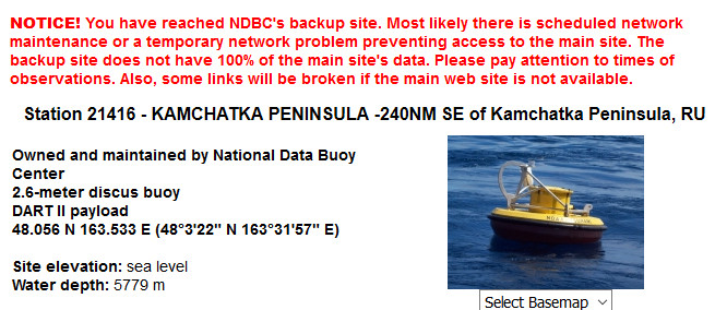
I have to say that I do not watch these buoys with any frequency as to be perfectly honest they do not interest me that much - except, as you mentioned, where they can indicate a rise in the ocean floor.
Right now the buoy off Kamchatka is in event mode - not really surprising considering it got all shook up.
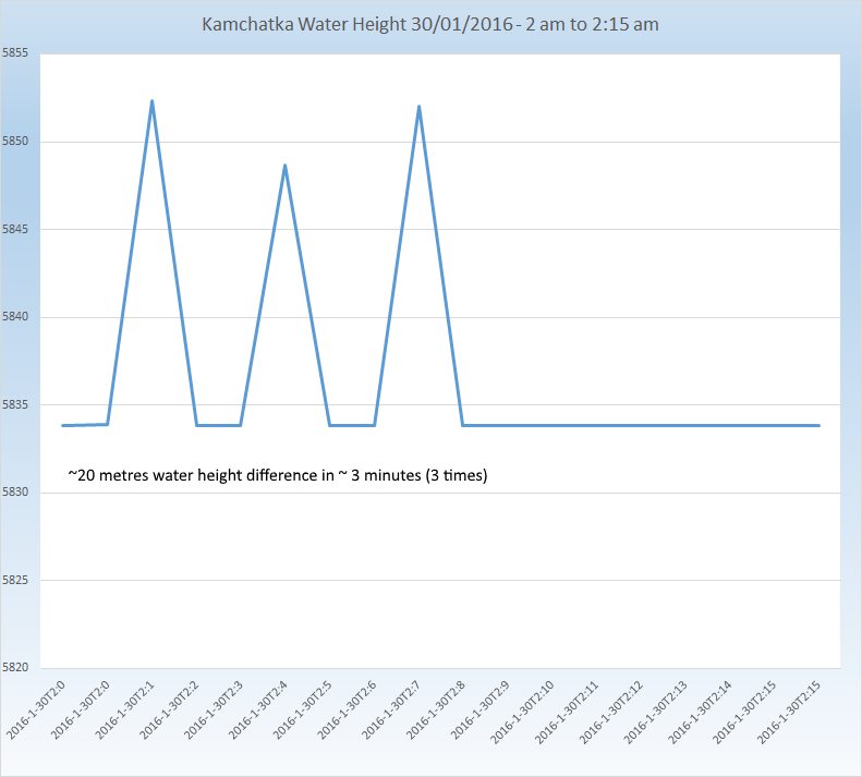
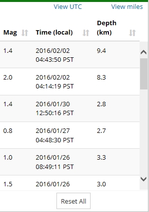
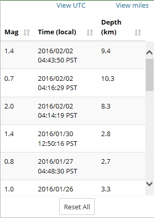
Expanding the data to cover 5 days (27/28/29/30/31) we can see that the buoy went into event mode around 2am on the 30th Jan
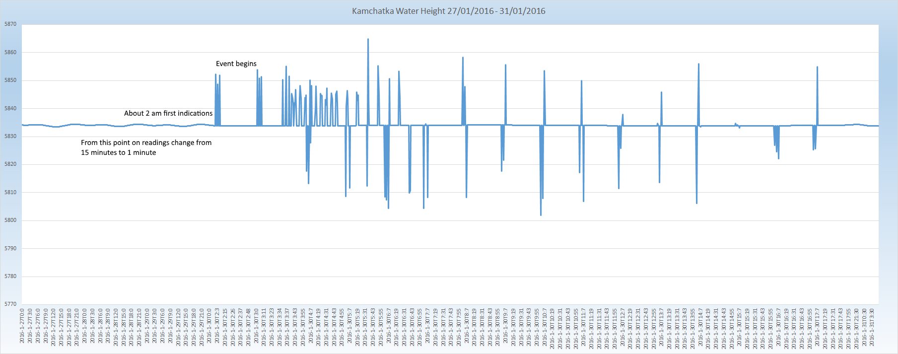
Click the image to enlarge
So there was a 'warning' of around 90 minutes - BUT, if you were looking at that instrument at the time would you have said an earthquake was imminent? I somehow doubt it as there was a ~20 metre height change in a couple of minutes.
I would have said "anomaly". Of course subsequent events said no, not an anomaly, and I think this possibly answers your question in that yes it would take time to determine that cause of a change to the pattern.
Remember of course that any pressure difference cause by the Magnetohydrodynamic drive on secret Gubbermint submarines would be known about but never divulged - it would be an anomaly.
The problem with this is that we - meaning us lower life forms - do not really have access to the sort of longer term data that would show displacement, however I am sure that the men in white coats have access. I tried to get the data from 2007 which is apparently available - but try and get it!
I have to say that I do not watch these buoys with any frequency as to be perfectly honest they do not interest me that much - except, as you mentioned, where they can indicate a rise in the ocean floor.
Right now the buoy off Kamchatka is in event mode - not really surprising considering it got all shook up.
Expanding the data to cover 5 days (27/28/29/30/31) we can see that the buoy went into event mode around 2am on the 30th Jan

Click the image to enlarge
So there was a 'warning' of around 90 minutes - BUT, if you were looking at that instrument at the time would you have said an earthquake was imminent? I somehow doubt it as there was a ~20 metre height change in a couple of minutes.
I would have said "anomaly". Of course subsequent events said no, not an anomaly, and I think this possibly answers your question in that yes it would take time to determine that cause of a change to the pattern.
Remember of course that any pressure difference cause by the Magnetohydrodynamic drive on secret Gubbermint submarines would be known about but never divulged - it would be an anomaly.
The problem with this is that we - meaning us lower life forms - do not really have access to the sort of longer term data that would show displacement, however I am sure that the men in white coats have access. I tried to get the data from 2007 which is apparently available - but try and get it!
M6.2 - M6.6, NE of the North Island NZ, 8am NZDT
don't know how to set a link here using my cell phone.
edit on 02000000313116 by muzzy because: (no reason given)
don't know how to set a link here using my cell phone.
edit on 02000000313116 by muzzy because: (no reason given)
a reply to: PuterMan
Ha.. Thats the message I have been getting all week. So I figured I would wait until this week to look more into past data.
That long term data is one of the things I am hoping to get a look at. I have not received a reply from Mr. Stevens.
Thank you PuterMan for posting this information. I alway's learn from you. Were you ever a teacher? If not, you should be.
a reply to: muzzy
earthquake.usgs.gov...
USGS is showing it at a 6.2. But it looked bigger to me. Are you seeing it as a 6.6 ?
Now here it is a 5.8
www.emsc-csem.org...
I see this one that USGS didn't even list.
www.emsc-csem.org...
earthquake.usgs.gov...
USGS is showing it at a 6.2. But it looked bigger to me. Are you seeing it as a 6.6 ?
Now here it is a 5.8
www.emsc-csem.org...
edit on 1-2-2016 by crappiekat because: to add
I see this one that USGS didn't even list.
www.emsc-csem.org...
edit on 1-2-2016 by crappiekat because: to add
geoneta reply to: crappiekat
geonet are saying 6.6, that will be ML so could well be just 6.2 Mw on conversion
geonet are saying 6.6, that will be ML so could well be just 6.2 Mw on conversion
a reply to: hiddenNZ
what do you mean "that shallow" ? it was 366 km deep!
www.geonet.org.nz...
plenty of felt reports, even down here where I am though I didn't feel it at work.
On return to home and access to my archives, the last shallow quake for NZ in that M range was
6.2331-24/04/2015 03:36:42
ID: 2015p305812 Network: geonet
Date/Time NZST: 24/04/2015 15:36:42
Date/Time UTC: 24/04/2015 03:36:42
Latitude, Longitude: -42.0902, 173.068
Magnitude: 6.2331M
Depth: 51.52 km
Energy Released: 33733.2608 tonnes of TNT
Location: South Marlborough-North Canterbury
tauhouanga.blogspot.co.nz... (bit of a mess since Google quit providing a useable service)
M5.8 - 135km NNE of Yonakuni, Japan
25.617 °N 123.451 °E depth=189.1 km (117.5 mi)
Nearby Cities
135km (84mi) NNE of Yonakuni, Japan
157km (98mi) NNW of Ishigaki, Japan
180km (112mi) ENE of Keelung, Taiwan
195km (121mi) ENE of Yilan, Taiwan
1015km (631mi) ENE of Hong Kong, Hong Kong
USGS
M5.6 - 85km E of Miyako, Japan
39.667 °N 142.953 °E depth=17.5 km (10.9 mi)
Nearby Cities
85km (53mi) E of Miyako, Japan
89km (55mi) ENE of Yamada, Japan
96km (60mi) ENE of Otsuchi, Japan
102km (63mi) ENE of Kamaishi, Japan
526km (327mi) NNE of Tokyo, Japan
USGS
Good news on the funding front for early earthquake warning systems and new seismic monitoring equipment.
University of Washington
University of Washington
1)The UW; the University of California, Berkeley; California Institute of Technology; and the U.S. Geological Survey were awarded $3.6 million in funding today from the Gordon and Betty Moore Foundation to help advance the earthquake early warning system.
2)Washington Gov. Jay Inslee’s office today announced its support with new commitments toward earthquake preparedness, including $4.6 million to identify and map geologic hazards in the state.
3)Puget Sound Energy Foundation is donating $100,000 to the Pacific Northwest Seismic Network over four years to buy eight strong-motion seismometers
4)Amazon Catalyst, a partnership launched last year between Amazon Corp. and the UW, is funding a UW group that will develop MegaShake, a new system that will combine GPS and seismic data to accurately identify incoming earthquakes above a magnitude 7.
Also, John Vidale, director of the Pacific Northwest Seismic Network, spoke in D.C. this morning.
(his talk begins at 1:45:00 in the below video)
White House Earthquake Resilience Summit, in its entirety:
Here is one more link outlining the new funding and private/public cooperation toward resiliencey in the face of disaster.
Geek Wire
edit on 2/2/2016 by Olivine because: add link
a reply to: muzzy
So true, Muzzy.
I wish my elected officials would cut military spending by a whole lot, a little, heck, even a few percent would be terrific.
How many more horrifically efficient ways can they dream up to kill people?
I'm pretty sure we have it perfected.
So true, Muzzy.
I wish my elected officials would cut military spending by a whole lot, a little, heck, even a few percent would be terrific.
How many more horrifically efficient ways can they dream up to kill people?
I'm pretty sure we have it perfected.
a reply to: Olivine
Hi Olivine,
Thanks for posting this. I spent the evening reading and listening.
I think it is so cool that they now can actually see how the plates and mantle are moving. And that the plate isn't moving uniformly. Therefore "The Big One" might not be as big.
When I watched the video, I jumped around alot and some I didn't even listen to. (Long video) But I got the impression that they were having some resistance from the government to restructure government buildings. Thought about this more this morning, and I am going to go back and watch some more. What's that all about? If the government won't adhere to the building codes, how do you expect others too?
new topics
-
We need less laws in the UK not more
General Chit Chat: 2 hours ago -
The Baloney aka BS Detection Kit
Social Issues and Civil Unrest: 7 hours ago -
Suspected Iranian agent working for Pentagon while U.S. coordinated defense of Israel
US Political Madness: 7 hours ago -
How does my computer know
Education and Media: 10 hours ago
top topics
-
Suspected Iranian agent working for Pentagon while U.S. coordinated defense of Israel
US Political Madness: 7 hours ago, 13 flags -
USO 10 miles west of caladesi island, Clearwater beach Florida
Aliens and UFOs: 14 hours ago, 9 flags -
The Baloney aka BS Detection Kit
Social Issues and Civil Unrest: 7 hours ago, 6 flags -
How does my computer know
Education and Media: 10 hours ago, 3 flags -
We need less laws in the UK not more
General Chit Chat: 2 hours ago, 3 flags
active topics
-
Suspected Iranian agent working for Pentagon while U.S. coordinated defense of Israel
US Political Madness • 16 • : bastion -
It has begun... Iran begins attack on Israel, launches tons of drones towards the country
World War Three • 646 • : YourFaceAgain -
DWAC Trumps Truth social stock soars .
Mainstream News • 109 • : TinfoilTophat -
Running Through Idiot Protestors Who Block The Road
Rant • 59 • : DBCowboy -
The Baloney aka BS Detection Kit
Social Issues and Civil Unrest • 6 • : nugget1 -
President BIDEN Warned IRAN Not to Attack ISRAEL - Iran Responded with a Military Attack on Israel.
World War Three • 41 • : gortex -
Abortions in first 12 weeks should be legalised in Germany, commission says
Medical Issues & Conspiracies • 14 • : Consvoli -
We need less laws in the UK not more
General Chit Chat • 3 • : dothedew -
Afterlife, unknown, so prepare, or just go into the unknown (bad)!!
ATS Skunk Works • 54 • : Kennyb75 -
-@TH3WH17ERABB17- -Q- ---TIME TO SHOW THE WORLD--- -Part- --44--
Dissecting Disinformation • 478 • : cherokeetroy