It looks like you're using an Ad Blocker.
Please white-list or disable AboveTopSecret.com in your ad-blocking tool.
Thank you.
Some features of ATS will be disabled while you continue to use an ad-blocker.

Quake Watch 2016
page: 88share:
F-E Region: Romania
Time: 2016-12-27 23:20:56.1 UTC
Magnitude: 5.6 (Mw)
Epicenter: 26.64°E 45.73°N
Depth: 94 km
Status: M - manually revised
geofon.gfz-potsdam.de...
I wonder if this is "Vrancea deep" I kept seeing in the historical records, although this one is actually not very deep.
Must look into that more
Yes it is,
here is one from the year 1107
same spot
www.emidius.eu...
SHEEC has got 67 [Vrancea deep] quakes over 4.7-7.9 at the same location lat 45.700, Long 26.600, from 1107-1899, 20 of them over M7.
Note to self to check what this is about.
Why the same spot over and over? (now that would be hard to map on an interactive map)
Why is it called "deep"
Why just here?
There are 11 more entries without the "deep" on the end, slightly off lat/long by 0.2 degrees
Job for another day
Romania? I think of stone houses like the most of Eastern Europe, any decent quake there is likely topple homes and kill someone
edit on
1200000036236216 by muzzy because: (no reason given)
a reply to: muzzy
WTF? Its only been 2 hrs
check the times on the posts
I'm going to paste that on every post until they fix the damn thing
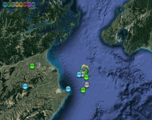
anyway I processed the GUC data off Datapro and made a map
I believe this is the only one on the internet, I can't find anything on GUC that shows the whole series as one
83 events so far
not many for a 7.6, surely there must be more?
area looks a bit like our Fiordland
this map is a bit of a look into the future for my NZ 2017 blog, I have been experimenting with mini icons for the daily thumbnails that appear on the main page, and settled on the same orbs as the NZtopo map on the individual page, but @ 50% size. It makes it easier to ID them individually on a small map
I did a couple of test maps
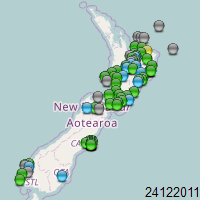
one for 26.12.2016, you can still see the Marlborough aftershock series
and another 24.12.2011, the day after the New Brighton M6
speaking of Fiordland,
haven't had much action down there this year
is that the next breaking point?, or Cook Strait?
You have exceeded the maximum window of 4 hours allowed to edit your post.
WTF? Its only been 2 hrs
check the times on the posts
I'm going to paste that on every post until they fix the damn thing
anyway I processed the GUC data off Datapro and made a map
I believe this is the only one on the internet, I can't find anything on GUC that shows the whole series as one
83 events so far
not many for a 7.6, surely there must be more?
area looks a bit like our Fiordland
this map is a bit of a look into the future for my NZ 2017 blog, I have been experimenting with mini icons for the daily thumbnails that appear on the main page, and settled on the same orbs as the NZtopo map on the individual page, but @ 50% size. It makes it easier to ID them individually on a small map
I did a couple of test maps
one for 26.12.2016, you can still see the Marlborough aftershock series
and another 24.12.2011, the day after the New Brighton M6
edit on 1200000036236216 by muzzy because: speling mistakes
speaking of Fiordland,
haven't had much action down there this year
is that the next breaking point?, or Cook Strait?
edit on 1200000036236216 by muzzy because: add an observation and a question
a reply to: muzzy
I think it must be Excel as the csv file looks fine in Notepad/Textpad.
de Ollagüe
Yes just checked, it is Excel causing the problem. You can install Spanish (Chile) as an editing language but if you want to display it:
You can buy a Language Pack, which includes:
Display in selected language
Par for the course I guess.
FEGL Lookup returns a seismic region of Andean South America and a sub region of Off Coast of Central Chile, but I would imagine the sub regions are not very 'narrow'. Actually they don't look too bad:
102 8 0 1 Near West Coast Of Colombia
103 8 0 1 Colombia
104 8 0 1 Off Coast Of Ecuador
105 8 0 1 Near Coast Of Ecuador
106 8 0 1 Colombia-Ecuador Border Region
107 8 0 1 Ecuador
108 8 0 1 Off Coast Of Northern Peru
109 8 0 1 Near Coast Of Northern Peru
110 8 0 1 Peru-Ecuador Border Region
111 8 0 1 Northern Peru
112 8 0 1 Peru-Brazil Border Region
113 8 0 1 Western Brazil
114 8 0 1 Off Coast Of Peru
115 8 0 1 Near Coast Of Peru
116 8 0 1 Central Peru
117 8 0 1 Southern Peru
118 8 0 1 Peru-Bolivia Border Region
119 8 0 1 Northern Bolivia
120 8 0 1 Central Bolivia
121 8 0 1 Off Coast Of Northern Chile
122 8 0 1 Near Coast Of Northern Chile
123 8 0 1 Northern Chile
124 8 0 1 Chile-Bolivia Border Region
125 8 0 1 Southern Bolivia
126 8 0 1 Paraguay
127 8 0 1 Chile-Argentina Border Region
128 8 0 1 Jujuy Province. Argentina
129 8 0 1 Salta Province. Argentina
130 8 0 1 Catamarca Province. Argentina
131 8 0 1 Tucuman Province. Argentina
132 8 0 1 Santiago Del Estero Prov.. Arg.
133 8 0 1 Northeastern Argentina
134 8 0 1 Off Coast Of Central Chile
135 8 0 1 Near Coast Of Central Chile
136 8 0 1 Central Chile
137 8 0 1 San Juan Province. Argentina
138 8 0 1 La Rioja Province. Argentina
139 8 0 1 Mendoza Province. Argentina
140 8 0 1 San Luis Province. Argentina
141 8 0 1 Cordoba Province. Argentina
142 8 0 1 Uruguay
When I get a moment I will make that CSV file include the FE Regions detail, perhaps as an option, as number or as a name. Might be a few days before I get round to it.
Re edit time, this is something we have banged on about for literally YEARS now and they still have not fixed it. Personally I don't mind if the window is 2 hours or 4 hours, but I would prefer 4. What I do mind is the incompetent programming that says you have 4 hours but only allows 2. There is no excuse for that level of deficiency in mathematics. I know the wheels of organisations turn slowly but you would think after several years they could have managed to fix such a small but important glitch.
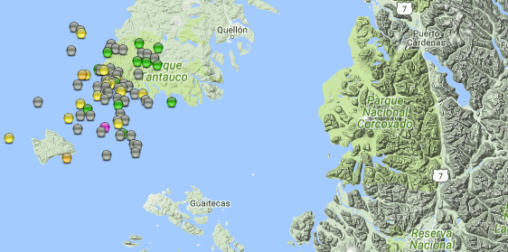
not sure if its Excel that can't recognise the foriegn letters
eg
66 km al O de Quellón
100 km al SE de Ollagü
I think it must be Excel as the csv file looks fine in Notepad/Textpad.
de Ollagüe
Yes just checked, it is Excel causing the problem. You can install Spanish (Chile) as an editing language but if you want to display it:
You can buy a Language Pack, which includes:
Display in selected language
Par for the course I guess.
FEGL Lookup returns a seismic region of Andean South America and a sub region of Off Coast of Central Chile, but I would imagine the sub regions are not very 'narrow'. Actually they don't look too bad:
102 8 0 1 Near West Coast Of Colombia
103 8 0 1 Colombia
104 8 0 1 Off Coast Of Ecuador
105 8 0 1 Near Coast Of Ecuador
106 8 0 1 Colombia-Ecuador Border Region
107 8 0 1 Ecuador
108 8 0 1 Off Coast Of Northern Peru
109 8 0 1 Near Coast Of Northern Peru
110 8 0 1 Peru-Ecuador Border Region
111 8 0 1 Northern Peru
112 8 0 1 Peru-Brazil Border Region
113 8 0 1 Western Brazil
114 8 0 1 Off Coast Of Peru
115 8 0 1 Near Coast Of Peru
116 8 0 1 Central Peru
117 8 0 1 Southern Peru
118 8 0 1 Peru-Bolivia Border Region
119 8 0 1 Northern Bolivia
120 8 0 1 Central Bolivia
121 8 0 1 Off Coast Of Northern Chile
122 8 0 1 Near Coast Of Northern Chile
123 8 0 1 Northern Chile
124 8 0 1 Chile-Bolivia Border Region
125 8 0 1 Southern Bolivia
126 8 0 1 Paraguay
127 8 0 1 Chile-Argentina Border Region
128 8 0 1 Jujuy Province. Argentina
129 8 0 1 Salta Province. Argentina
130 8 0 1 Catamarca Province. Argentina
131 8 0 1 Tucuman Province. Argentina
132 8 0 1 Santiago Del Estero Prov.. Arg.
133 8 0 1 Northeastern Argentina
134 8 0 1 Off Coast Of Central Chile
135 8 0 1 Near Coast Of Central Chile
136 8 0 1 Central Chile
137 8 0 1 San Juan Province. Argentina
138 8 0 1 La Rioja Province. Argentina
139 8 0 1 Mendoza Province. Argentina
140 8 0 1 San Luis Province. Argentina
141 8 0 1 Cordoba Province. Argentina
142 8 0 1 Uruguay
When I get a moment I will make that CSV file include the FE Regions detail, perhaps as an option, as number or as a name. Might be a few days before I get round to it.
Re edit time, this is something we have banged on about for literally YEARS now and they still have not fixed it. Personally I don't mind if the window is 2 hours or 4 hours, but I would prefer 4. What I do mind is the incompetent programming that says you have 4 hours but only allows 2. There is no excuse for that level of deficiency in mathematics. I know the wheels of organisations turn slowly but you would think after several years they could have managed to fix such a small but important glitch.
a reply to: muzzy
We have observed this many times before. Chile does not have anything like the number of aftershocks after a big one by comparison to other areas. Maybe the faults are very sticky and after the stress overcomes and produces the main shock the fault settles back to the consistency of hard toffee waiting from more stress rather than caramel sliding about befor settling down. Praline anyone?
not many for a 7.6, surely there must be more?
We have observed this many times before. Chile does not have anything like the number of aftershocks after a big one by comparison to other areas. Maybe the faults are very sticky and after the stress overcomes and produces the main shock the fault settles back to the consistency of hard toffee waiting from more stress rather than caramel sliding about befor settling down. Praline anyone?
estimated 6.5 or so just hit Japan.... will know more in a minute.... maybe more like 5.9 to 6.2... we'll see shortly.
Yep USGS: 5.9
Amazing, they posted before EMSC did for a change
earthquake.usgs.gov...
JMA: 6.3
www.jma.go.jp...
edit on Wed Dec 28th
2016 by TrueAmerican because: (no reason given)
Yep USGS: 5.9
Amazing, they posted before EMSC did for a change
earthquake.usgs.gov...
edit on Wed Dec 28th 2016 by TrueAmerican because: (no reason
given)
JMA: 6.3
www.jma.go.jp...
edit on Wed Dec 28th 2016 by TrueAmerican because: (no reason given)
And......
We have a swarm going on in the area of Hawthorne/Bridgeport Nevada.
Started out with (2) 5.7's
earthquake.usgs.gov...-info
108 incidents in the area so far.
TA, just saw your thread.
That's what I get for sleeping in.
We have a swarm going on in the area of Hawthorne/Bridgeport Nevada.
Started out with (2) 5.7's
earthquake.usgs.gov...-info
108 incidents in the area so far.
TA, just saw your thread.
That's what I get for sleeping in.
edit on 28-12-2016 by crappiekat because: to add
a reply to: crappiekat
Wow these are pretty significant seeing as there hasn't been a 5 in the USA mainland since .... ages?
And not the same Hawthorne area as the Swarm earlier this year, these just west of the WhiskeyFlat-Alkali Valley section @ Mud Springs/Aurora Crater
volcanic?
eqarchives.blogspot.co.nz...
Wow these are pretty significant seeing as there hasn't been a 5 in the USA mainland since .... ages?
And not the same Hawthorne area as the Swarm earlier this year, these just west of the WhiskeyFlat-Alkali Valley section @ Mud Springs/Aurora Crater
volcanic?
eqarchives.blogspot.co.nz...
edit on 1200000036236216 by muzzy because: (no reason given)
a reply to: muzzy
Yea, I think the last was a 5.6 in Oklahoma, back in September? I think.
Then we had that 6.5, But that was off shore. Early December 2016.
Alot of folks watching this.
Morango Valley acting up too. Just east of San Andreas in Southern Cali.
earthquake.usgs.gov...-info
Yea, I think the last was a 5.6 in Oklahoma, back in September? I think.
Then we had that 6.5, But that was off shore. Early December 2016.
Alot of folks watching this.
Morango Valley acting up too. Just east of San Andreas in Southern Cali.
earthquake.usgs.gov...-info
edit on 28-12-2016 by crappiekat because: to add
Public ID 2016p981371
Intensity strong
Universal Time December 29 2016, 2:34:33
NZ Daylight Time Thu, Dec 29 2016, 3:34:33 pm
Depth 28 km
Magnitude 5.4
Location 35 km east of Seddon
Latitude, Longitude -41.64, 174.46
www.geonet.org.nz...
could go bigger, its still automatic
shook the heck at our place, it was one of those that you are not sure if it's going to keep going
middle of Cook Strait.
Something this size will maybe take a few buildings in Wellington that are Red stickered over the "tipping point" to require demolition
5.5 reviewed
Intensity Reports
extreme 11
severe 17
strong 544
moderate 2408
light 3241
weak 1653
Total 7874
This one was a day late!, I just split the Kaikoura-Cook aftershock series into its 2nd map, just past the 10,112 count yesterday.
This is an extension of those events, same fault as the 2013 5.7's, this one 4km away to the east
Intensity strong
Universal Time December 29 2016, 2:34:33
NZ Daylight Time Thu, Dec 29 2016, 3:34:33 pm
Depth 28 km
Magnitude 5.4
Location 35 km east of Seddon
Latitude, Longitude -41.64, 174.46
www.geonet.org.nz...
could go bigger, its still automatic
shook the heck at our place, it was one of those that you are not sure if it's going to keep going
middle of Cook Strait.
Something this size will maybe take a few buildings in Wellington that are Red stickered over the "tipping point" to require demolition
edit on
1200000036236216 by muzzy because: (no reason given)
5.5 reviewed
edit on 1200000036236216 by muzzy because: (no reason given)
Intensity Reports
extreme 11
severe 17
strong 544
moderate 2408
light 3241
weak 1653
Total 7874
This one was a day late!, I just split the Kaikoura-Cook aftershock series into its 2nd map, just past the 10,112 count yesterday.
This is an extension of those events, same fault as the 2013 5.7's, this one 4km away to the east
edit on 1200000036236216 by muzzy because: (no reason given)
It was a weird one. It had a wave to it with some underlying shaking. We were sitting outside in Nelson and first we thought it was the wind. It
went on for quite a bit, that's why it was so confusing.
a reply to: muzzy
cataloged at 5.5435ML
looks like it was on the Cloudy undersea Fault
map on this page, I can't copyandsave it
www.niwa.co.nz...
cataloged at 5.5435ML
looks like it was on the Cloudy undersea Fault
We have found eight prehistoric earthquakes on the Wairau Fault of more than magnitude seven; six on the Cloudy Fault; and five on the Vernon Fault, which have all been big earthquakes in the past 18 000 years
map on this page, I can't copyandsave it
www.niwa.co.nz...
edit on 1200000036236216 by muzzy because: (no reason given)
Oh my God, I only go away for two days on a fever trip and I come back and Nevada went off. Just before I got the worst flu I've had in decades and
became almost catatonic, I wondered to myself if all the drop offs in activity there meant it was over , or other. Wow. Two at 5.7M quite the uptick.
a reply to: Anneke
I would say 50% of the crowds don't understand the game either. We had the game on TV but I wasn't in the room at the time. I was wondering if they felt the Quake and stopped the game.
No mention of the Quake on the 6 o'clock news either, we must be getting complacent
I would say 50% of the crowds don't understand the game either. We had the game on TV but I wasn't in the room at the time. I was wondering if they felt the Quake and stopped the game.
No mention of the Quake on the 6 o'clock news either, we must be getting complacent
edit on 1200000036336316 by muzzy because: (no reason
given)
a reply to: ericblair4891
Yeah it's often when things are going quiet that one should be on their guard. I used to be able to predict M5 here in NZ based on the TTNT energy release dropping below 6 tons/day with over 80% accuracy, but Canterbury 2011 changed all that and it doesn't work any more.
Yeah it's often when things are going quiet that one should be on their guard. I used to be able to predict M5 here in NZ based on the TTNT energy release dropping below 6 tons/day with over 80% accuracy, but Canterbury 2011 changed all that and it doesn't work any more.
edit on
1200000036336316 by muzzy because: Damn mobile phone doing its word prediction thing
originally posted by: TrueAmerican
estimated 6.5 or so just hit Japan.... will know more in a minute.... maybe more like 5.9 to 6.2... we'll see shortly.
Yep USGS: 5.9
Amazing, they posted before EMSC did for a change
earthquake.usgs.gov...
JMA: 6.3
www.jma.go.jp...
Lat/Long: 36.72, 140.574;
JST: 28/12/2016 21:38:49;
UTC: 28/12/2016 12:38:49;
Depth: 10.8;
Mag: 6.3 ML;
Location: NORTHERN IBARAKI PREF;
Energy Released: 42501.8979 tonnes of TNT;
Source: JMA Status: reviewed
interactive map for 28/12JST 131 aftershocks to the end of that day
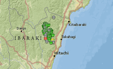
Almost the exact spot (380 metres NW) of a 2011 M5.7 aftershock of the M9.0
Lat/Long: 36.717, 140.576
UTC: 11/03/2011 05:54:42
JST: 11/03/2011 14:54:42
0:08:24 (hh:mm:ss) after 9.0 Main shock
Depth: 9.1
Mag: 5.7 ML
Location: NORTHERN IBARAKI PREF
Energy Released: 0.06339332 tonnes of TNT
Source: JMA Status: Reviewed Dec 2015
I was sure there was a M7 in those mountains after the 9.0, because it has basically been shaking there since then (5 years) there are always quake there EVERY day now. Prior to the 9.0 it was a non seismic area.
I had a look at my Japan 2011 data but can't see it, I only went for 20 days after the 9.0, maybe it was later.
No big deal, I'm going to have to redo the whole thing again anyway before Sept 2017 (Dropbox file dropout)
came across this news item japantimes 2 injured
edit on 1200000036336316 by muzzy because: (no reason given)
That Japan map posted above link is the 2nd one I have done under the new Dropbox terms, seems to work OK.
You won't notice anything different, all that has changed is the link location address of the file that made the map, and the icons are slightly different location too. I might as well get started now, rather than wait until Sep next year, less I will have to redo.
Basically you have to have a separate Folder directly in the Dropbox site now, up until now all my Folders were in Dropbox/Public/ as that was the way it was done when they started out.
Now they are changing the layout (moving the goal posts) in Sept 2017 (as Puterman mentioned a page back) and the Public Folder will cease to exist, thereby any Folder inside the Public Folder will also cease to exist.
This is BIGGER than the Google Maps dropout disaster of Feb 2015, as I will loose ALL my file links, and none of the maps (that is the NZTopo replacement for Google Maps) will work.
I know its not possibly so focused, but to me this seems like a personal assault on my earthquake mapping work directly from all sides, Google, Bing, Dropboxall doing whatever they can to make it hard to get the info out. I mean its not like there are millions of readers following me instead of the PTB sites. Geonet has almost come close to what I was doing 2 years ago with their map/stats popup.
The reason I started doing this at all was because back 5-10 years ago no one was doing interactive maps, now everyone has just about caught up.
Chile are still not mapping interactively, maybe I'll show them how to do it, I ran for a while a couple of years ago, but it was hard work downloading off their GUC site. Puterman is working on a program convertor right now, so it might be a bit easier. Chile is a long country, the map will be a big one.
I'm going to bottle whatever makes a fever dream and sell it like a drug. Wait, it would be a drug I'm supposing. Something different than normal
dreams, normal nightmares. Anyway, can't think right at all. However, I will say. Earthquakes comes in clusters. Look at Europe lately. And let's
through in the whole Mediterranean overall. It slowed down other than a notable one in Romania. Yet, while ago it was rocking all over.
This is the pattern. Oh, forget me. I honestly think we have room for one more over 7 before 2017. I won't be surprised on bit. Alaskan volcano erupts and whispers to me. Gosh, oh golly gee, I told you this influenza fevered thinking is the good stuff. Do you remember when you were a kid and you first got the real flu and you thought you were going to die? That was the thing, the thing I forgot, the "i'm going to die feeling" and I hadn't forgotten how it felt because I hadn't gotten that sick in so long.
I guess I'm reasonably health since I know now what real unhealthy is for comparison.
In general, it's still a bit active all over and big one go bang. i stop now
Just want to say thanks for reading this Thread, 2016 is about over for me, being 12 hours ahead of UTC, its only 6 hours away.
If you are thinking in UTC (and you should be if you are serious about earthquake tracking) then there is still another 20 hours to go.
I was just going over my blog stats today, all my blogs relating to earthquakes. I added up all the visitors, there were 256,654 all up, but that is over a 10 year period. Of those only 770 were clicks off ATS Quake Watch, which surprised me, I expected way more. So it is quite obvious that the maps and links are not posted here to create traffic to my blogs, it just ain't happening anyway.
Actually most of my visitors are from NZ, which I suppose is logical when 10/15 of my blogs are covering NZ.
The reason I did a review is to see what people are interested in going forwards into 2017
NZ5+Blog with 51,447 visitors is 2nd on the list, after NZ2006 Blog which is now defunct, so I will concentrate on getting that up to scratch before the Dropbox dropout in Sept 2017. It works at the moment as I used NZTopo maps the last time I redid it, although the thumbnails on the front page are a mixed up mess.
The other years might as well drift off to oblivion, as there is no way I am going to rewrite 3650+ KMZ files and blog posts because of Dropbox.
The japaneq Blog is 5th on the list with 18,657 visitors so I might keep on with that. It is interesting as to what people read on that one, the Kyushu 2015 and Kumamoto 2016 big quakes are at the top, but E Off Fukushima and Eastern Tottori don't even make the top 10 pages visited, despite being the 3rd and 4th biggest aftershock series in japan this year.
the M6.5+ project Blog has had nothing but hassles from day 1, having to switch to Blogger from Wordpress (19,649 visitors when it died in Feb 2015), it has picked up another 7,347 visitors over 2 years up and running so there IS an interest out there, but I will have to do it ALL again (3rd time) now that Bing dropped out of the interactive map market as well as Google. That is a project worth pursuing as I have spent so much time researching the data, and I still am, currently back to 1865. Wish that ikimaps would get itself out of the Beta stage, its so damn slow.
edit on 1200000036536516 by muzzy because: (no reason given)
new topics
-
Ditching physical money
History: 1 hours ago -
One Flame Throwing Robot Dog for Christmas Please!
Weaponry: 2 hours ago -
Don't take advantage of people just because it seems easy it will backfire
Rant: 2 hours ago -
VirginOfGrand says hello
Introductions: 3 hours ago -
Should Biden Replace Harris With AOC On the 2024 Democrat Ticket?
2024 Elections: 3 hours ago -
University student disciplined after saying veganism is wrong and gender fluidity is stupid
Education and Media: 6 hours ago -
Geddy Lee in Conversation with Alex Lifeson - My Effin’ Life
People: 7 hours ago -
God lived as a Devil Dog.
Short Stories: 7 hours ago -
Police clash with St George’s Day protesters at central London rally
Social Issues and Civil Unrest: 9 hours ago -
TLDR post about ATS and why I love it and hope we all stay together somewhere
General Chit Chat: 10 hours ago
top topics
-
Hate makes for strange bedfellows
US Political Madness: 12 hours ago, 18 flags -
Who guards the guards
US Political Madness: 14 hours ago, 13 flags -
University student disciplined after saying veganism is wrong and gender fluidity is stupid
Education and Media: 6 hours ago, 11 flags -
Police clash with St George’s Day protesters at central London rally
Social Issues and Civil Unrest: 9 hours ago, 8 flags -
TLDR post about ATS and why I love it and hope we all stay together somewhere
General Chit Chat: 10 hours ago, 7 flags -
Should Biden Replace Harris With AOC On the 2024 Democrat Ticket?
2024 Elections: 3 hours ago, 5 flags -
Has Tesla manipulated data logs to cover up auto pilot crash?
Automotive Discussion: 16 hours ago, 3 flags -
One Flame Throwing Robot Dog for Christmas Please!
Weaponry: 2 hours ago, 2 flags -
Don't take advantage of people just because it seems easy it will backfire
Rant: 2 hours ago, 2 flags -
Geddy Lee in Conversation with Alex Lifeson - My Effin’ Life
People: 7 hours ago, 2 flags
active topics
-
Ditching physical money
History • 9 • : VirginOfGrand -
The Superstition of Full Moons Filling Hospitals Turns Out To Be True!
Medical Issues & Conspiracies • 21 • : VirginOfGrand -
-@TH3WH17ERABB17- -Q- ---TIME TO SHOW THE WORLD--- -Part- --44--
Dissecting Disinformation • 633 • : Justoneman -
VirginOfGrand says hello
Introductions • 1 • : VirginOfGrand -
Candidate TRUMP Now Has Crazy Judge JUAN MERCHAN After Him - The Stormy Daniels Hush-Money Case.
Political Conspiracies • 740 • : matafuchs -
Should Biden Replace Harris With AOC On the 2024 Democrat Ticket?
2024 Elections • 33 • : BernnieJGato -
Gold and silver prices....woo hoo
History • 84 • : annonentity -
The Democrats Take Control the House - Look what happened while you were sleeping
US Political Madness • 108 • : Zanti Misfit -
BREAKING! Another Bridge Hit by a barge #3 this week.
Mainstream News • 110 • : RookQueen2 -
One Flame Throwing Robot Dog for Christmas Please!
Weaponry • 4 • : Dalamax