It looks like you're using an Ad Blocker.
Please white-list or disable AboveTopSecret.com in your ad-blocking tool.
Thank you.
Some features of ATS will be disabled while you continue to use an ad-blocker.

Quake Watch 2016
page: 83share:
a reply to: Flavian
The short answer is no there has been no new recorded vent activity, no spike in earthquakes there.
Any recorded earthquake events at Taupo can be viewed on the daily maps I make nzeq2016.blogspot.co.nz...
I'm new to this GPS stuff, but here is a reading from the GPS stations around Taupo caldera, the day of the 7.8 quake is marked for reference
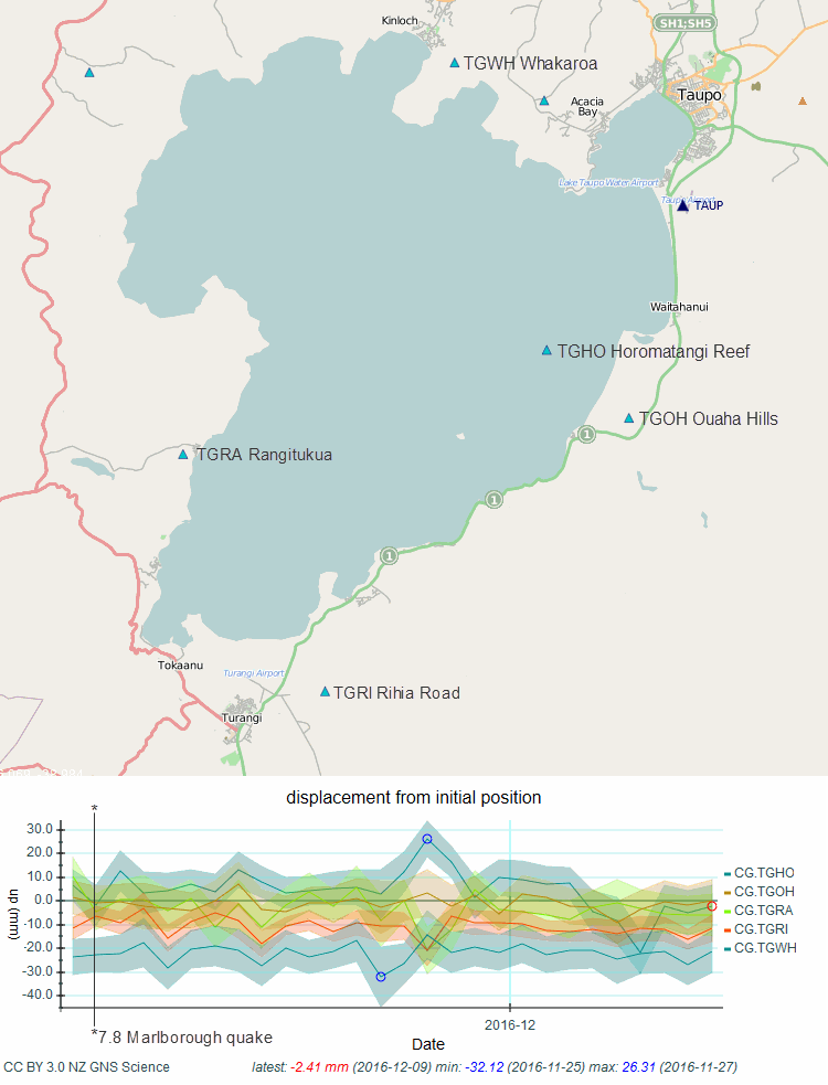
TGHO Horomatangi Reef did show some uplift (about 20mm) on the 27th Nov NZST, there was a M1.87 quake not far to the south west right in the middle of the lake 2016-11-27 02:58:40;
and then a 40mm drop over 4 days 4th-7th Dec inclusive
there were some earthquakes over this period around the volcano
M1.25, 05/12/2016 09:23:48; middle of the lake
M1.23, 05/12/2016 09:25:41; middle of the lake
M2.17, 05/12/2016 01:57:44; near Kuaratau (nr TGRA station)
M2.3, 04/12/2016 23:39:09; near Waihaha (western bay)
M3.18, 05/12/2016 13:21:34; near Waihaha (western bay)
M1.72, 06/12/2016 03:43:57; near Taupo Airport
M0.93, 06/12/2016 15:06:56; Stump Bay (between TGRA and TGRI stations)
if you want to have a go yourself, here is the stations map with the code names
and this is the query I used to get that graph. Copy and paste the address into your browser, then you can change the station codes or the date as you wish. You can delete or add stations, but make sure all the dots and commas are there and no spaces otherwise it won't work.
I use the map in one tab and the query in another so I don't get mixed up (but still do)
Someone with the spare time could do a "isthisthingon" yellowstone blog type coverage for Taupo volcano, I don't believe there is anything out there specifically with the quakes and the GPS for the area, just the drums and quakes pages on Geonet.
I presume you have read this Geonet pageTaupo
BTW Horomatangi Reef is the location of 2 hydrothermal vents
The short answer is no there has been no new recorded vent activity, no spike in earthquakes there.
Any recorded earthquake events at Taupo can be viewed on the daily maps I make nzeq2016.blogspot.co.nz...
I'm new to this GPS stuff, but here is a reading from the GPS stations around Taupo caldera, the day of the 7.8 quake is marked for reference
TGHO Horomatangi Reef did show some uplift (about 20mm) on the 27th Nov NZST, there was a M1.87 quake not far to the south west right in the middle of the lake 2016-11-27 02:58:40;
and then a 40mm drop over 4 days 4th-7th Dec inclusive
there were some earthquakes over this period around the volcano
M1.25, 05/12/2016 09:23:48; middle of the lake
M1.23, 05/12/2016 09:25:41; middle of the lake
M2.17, 05/12/2016 01:57:44; near Kuaratau (nr TGRA station)
M2.3, 04/12/2016 23:39:09; near Waihaha (western bay)
M3.18, 05/12/2016 13:21:34; near Waihaha (western bay)
M1.72, 06/12/2016 03:43:57; near Taupo Airport
M0.93, 06/12/2016 15:06:56; Stump Bay (between TGRA and TGRI stations)
if you want to have a go yourself, here is the stations map with the code names
and this is the query I used to get that graph. Copy and paste the address into your browser, then you can change the station codes or the date as you wish. You can delete or add stations, but make sure all the dots and commas are there and no spaces otherwise it won't work.
I use the map in one tab and the query in another so I don't get mixed up (but still do)
Someone with the spare time could do a "isthisthingon" yellowstone blog type coverage for Taupo volcano, I don't believe there is anything out there specifically with the quakes and the GPS for the area, just the drums and quakes pages on Geonet.
I presume you have read this Geonet pageTaupo
edit on 1200000034634616 by muzzy because: (no reason given)
BTW Horomatangi Reef is the location of 2 hydrothermal vents
edit on 1200000034634616 by muzzy because: (no reason given)
Checking in with an alert on the RSOE, "Mt. St. Helena" had an EQ recently. It is strange as the USGS site does not have this recent Activity marked,
and the RSOE only provides the time and place as of this posting. No magnitude.
From RSOE:
"A recent swarm of more than 120 earthquakes near Mount St. Helens -- all below a magnitude 0.5...."
From RSOE:
"A recent swarm of more than 120 earthquakes near Mount St. Helens -- all below a magnitude 0.5...."
a reply to: HollywoodFarmGirl
"recent" swarm ????
how recent
you can view Mt St Helens earthquakes here
www.pnsn.org...
smallest is -1.6 (that is micro japanese size)
I don't see 120 though, I only see 6 in the last week
Note: I couldn't find the =/- buttons on the map, had to click on "Show 20 most recent" top right corner above the map to open the map with the buttons, then back to "last 30 days" and the =/- stayed on.
RSOE are know for being wrong a lot of the time, I ask why RSOE even bother mentioning it if they haven't got the evidence (wheres the link?)
edit on 1200000034634616 by muzzy because: (no reason given)
Sorry about the links!
The alert map:
hisz.rsoe.hu...
Comment about swarms in here:
hisz.rsoe.hu...
Other details:
"Category Geo Geophysical (inc. landslide)
Certainty Observed Determined to have occurred or to be ongoing
Scope Public For general dissemination to unrestricted audiences
Severity Minor Minimal to no known threat to life or property
Urgency Past Responsive action is no longer required
Base data
EDIS Number EQ-20161213-56334-USA
Event type Earthquake
Date/Time December 13 2016 03:31 AM (UTC)
Last update December 13 2016 03:33 AM (UTC)
Cause of event
Damage level Is not or not known Damage level
Affected area Local events : The affected area up to a few kilometers
Geographic information
Continent North-America
Country USA
County / State State of Washington
Area Mount St. Helens Volcano
Settlement
Coordinate 45° 55.608,122° 22.829"
a reply to: HollywoodFarmGirl
I think its BS, maybe TrueAmerican can confirm from the seismos
Have a look here the only station with any activity is SEP at the caldera, no where near 120 earthquakes, even the ones on that are yesterday
volcanoes.usgs.gov...
I followed the Observatory mentioned in the story to get that page.
There are no alerts being issued by the said "Cascades Volcano Observatory in Vancouver, as reported in the Columbian"
volcanoes.usgs.gov...
it is probably just a reminder memo put out by the CVO to ensure future funding keep rolling in, and RSOE fell for it as being an alert
I think its BS, maybe TrueAmerican can confirm from the seismos
Have a look here the only station with any activity is SEP at the caldera, no where near 120 earthquakes, even the ones on that are yesterday
volcanoes.usgs.gov...
edit on 1200000034734716 by muzzy because: (no reason given)
I followed the Observatory mentioned in the story to get that page.
There are no alerts being issued by the said "Cascades Volcano Observatory in Vancouver, as reported in the Columbian"
volcanoes.usgs.gov...
it is probably just a reminder memo put out by the CVO to ensure future funding keep rolling in, and RSOE fell for it as being an alert
edit on
1200000034734716 by muzzy because: (no reason given)
a reply to: HollywoodFarmGirl
Yeah agreed.
RSOE is alright for an overview of what is happening, but you need to check other sources as well (which you did by checking USGS).
There are a few on ATS who rely on RSOE, but I'm not one of them.
Just had another look this morning, at New Zealand, they have a few of the earthquakes, but there are over 150 per day happening right now mostly in Marlborough and Cook Strait, so they are only telling half the story.
The only other hazard showing is a volcanic warning for Lake Rotorua Volcano.
has the dates , but nothing about what it was. link
You would think if RSOE is trolling the media for info to post that they would bother to add the info about what the event was about.
It was a geyser near the lake shore.
www.rotorualakescouncil.nz...
www.nzherald.co.nz...
I should have posted it on Volcano Watch
edit on 1200000034734716 by muzzy because: (no reason given)
Wakey wakey
M5.0 - 8km WNW of The Geysers, California
earthquake.usgs.gov...
This would be the biggest quake there ever?
Will research that right now
Yep
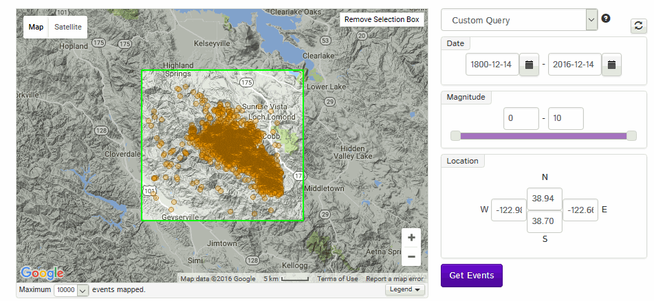
searching IRIS 1800-present 4.8 plus, 10km rectangle from this ones epicentre (covers the Geysers recent earthquake history area)
image below show last 10,000 events used to create the search area
Results;
2016-12-14 16:41:05
Northern California
Mw 5
38.82°
-122.84°
0.94 km
2007-04-24 21:08:28
Northern California
Mb 4.8
38.76°
-122.82°
7.6 km
2003-10-04 05:02:27
Northern California
Mb 4.8
38.81°
-122.83°
11.4 km
I also checked the Responses, to make sure it wasn't an error
earthquake.usgs.gov...
seems legit
was on GFZ as well
geofon.gfz-potsdam.de...
The reason for skepticism is this memo from Northern California Earthquake Data Center (NCEDC) on January 3rd, 2015
EGS Catalog Geysers Magnitude Errors
Also checked the Clear Lake Volcanic Field monitoring page from California Volcano Observatory
volcanoes.usgs.gov...
but they don't seem to have graphs on those station triangles, like Mt St Helens has
This is interesting, one of the aftershocks
2016-12-14 16:46:18 UTC 38.792°N 122.842°W -0.6 km depth
earthquake.usgs.gov...
most of the other quakes on the list (on the CVO link above) don't have the minus sign ahead of the figure, but some do
I wonder what this negative reading means?
part of the answer may be this
earthquake.usgs.gov...
which means the depth COULD be 3.3km?
M5.0 - 8km WNW of The Geysers, California
earthquake.usgs.gov...
This would be the biggest quake there ever?
Will research that right now
edit on 1200000034834816 by muzzy because: (no reason given)
Yep
searching IRIS 1800-present 4.8 plus, 10km rectangle from this ones epicentre (covers the Geysers recent earthquake history area)
image below show last 10,000 events used to create the search area
Results;
2016-12-14 16:41:05
Northern California
Mw 5
38.82°
-122.84°
0.94 km
2007-04-24 21:08:28
Northern California
Mb 4.8
38.76°
-122.82°
7.6 km
2003-10-04 05:02:27
Northern California
Mb 4.8
38.81°
-122.83°
11.4 km
edit on 1200000034834816 by muzzy because: (no reason given)
edit on 1200000034834816 by muzzy because: (no reason
given)
I also checked the Responses, to make sure it wasn't an error
earthquake.usgs.gov...
seems legit
was on GFZ as well
geofon.gfz-potsdam.de...
The reason for skepticism is this memo from Northern California Earthquake Data Center (NCEDC) on January 3rd, 2015
EGS Catalog Geysers Magnitude Errors
In reviewing Geysers data, the 4 events listed below had incorrect amplitudes from one station (DEB) that had a large amount of transient electronic noise. These amplitudes were previously included in the moment magnitude calculations for the events listed below, resulting in greatly exaggerated moment magnitude estimates. The corrected magnitude estimates, computed without the erroneous DEB amplitudes, are:
Date Time Lat Lon Depth Mag Magt Nst Gap Clo RMS SRC Event ID
----------------------------------------------------------------------------------------------
2014/04/05 19:30:20.53 38.84790 -122.83538 2.543 0.43 (formerly 4.92) ML 0 0 0 0.05 LBL 3383465
2014/04/05 19:52:57.37 38.84423 -122.82652 2.857 1.12 (formerly 4.87) ML 0 0 0 0.01 LBL 3383466
2014/04/05 20:04:52.30 38.80133 -122.82338 1.035 0.45 (formerly 5.06) ML 0 0 0 0.03 LBL 3383470
2014/04/07 01:18:36.17 38.83748 -122.78598 0.851 0.51 (formerly 4.65) ML 0 0 0 0.04 LBL 3383663
edit on 1200000034834816
by muzzy because: (no reason given)
Also checked the Clear Lake Volcanic Field monitoring page from California Volcano Observatory
volcanoes.usgs.gov...
but they don't seem to have graphs on those station triangles, like Mt St Helens has
edit on 1200000034834816 by muzzy because: (no reason
given)
This is interesting, one of the aftershocks
2016-12-14 16:46:18 UTC 38.792°N 122.842°W -0.6 km depth
earthquake.usgs.gov...
most of the other quakes on the list (on the CVO link above) don't have the minus sign ahead of the figure, but some do
I wonder what this negative reading means?
part of the answer may be this
Depth uncertainty -0.6 km ± 3.9
earthquake.usgs.gov...
which means the depth COULD be 3.3km?
edit on 1200000034834816 by muzzy because: (no reason given)
a reply to: muzzy
I took a little ride with the google car along Geyser Rd. crazy geography. I bet the geo-thermal plant has something to do with seeing that they are right nearby. Oh, a little aside. Frackers claim they don't contaminate the groundwater. The EPA came out with it's last report before Trump. So, for all of you that have come out of a cave, Trump has won and is President Elect of the most powerful country in the world. Our current timeline has before and after Christ. I'm comparing mind you. But, now there is before and after Trump. So, we are nearing day one of B.T., on January 19 or whatever when they crown him. ah. What was doing here?
Yes, the EPA says frackers are fracking up the water. The EPA, is like those one The Green Mile, dead men walking.
You get anything thing from them again. America is fracked.
Well, I'm ready for to give my report to the aliens so I can leave this planet and go on my next assignment. ah......
I'm glad I knew Trump would win on Sept 11 when Hillary fell down.
I was never in denial.
In conclusion. Man made earthquakes in the United States of America will increase many fold.
I shouldn't do this but whatever. This morning I listened to Linda Ronstadt doing "Crazy". I'm going to post it and you have to listen. The poor lady can't sing anymore and she was soooooooo goooooood. I was too young to really understand back then, thank god for you tube. She was amazing LIVE> or did they have auto tune back then. I tease my kid and say she's autotuned.
So, America, you....
Crazy.
edit on 14-12-2016 by ericblair4891 because: (no reason given)
originally posted by: muzzy
This is interesting, one of the aftershocks
2016-12-14 16:46:18 UTC 38.792°N 122.842°W -0.6 km depth
earthquake.usgs.gov...
most of the other quakes on the list (on the CVO link above) don't have the minus sign ahead of the figure, but some do
I wonder what this negative reading means?
part of the answer may be this
Depth uncertainty -0.6 km ± 3.9
earthquake.usgs.gov...
which means the depth COULD be 3.3km?
Or it could be 0.9 km± 0.4km (earthquake.usgs.gov...)
or 0.94km (ds.iris.edu...)
or 11.5km (earthquake.usgs.gov...-tensor?source=us&code=us_200080qv_mww)
or 5km (earthquake.usgs.gov...-tensor?source=nc&code=nc72737985_mt1)
or 1km (earthquake.usgs.gov...?source=at&code=at00oi6p0h)
geez what was it?
shallow anyway
I'm all for accuracy but 5 different depths is ridiculous
and LDEO will likely have 33km (if they list it at all)
I find it strange that when it comes to USA quakes IRIS doesn't give out much, like the Me_bb or Mw_hf energy figures for example
they still haven't calculated and released these for the 6.5 oof the coast 6.5 days ago
How can you compare apples with apples when they only sell bananas for the USA (ie compare quakes of the same size)
edit on 1200000034834816 by
muzzy because: (no reason given)
a reply to: muzzy
Ha! and today the energy data is released.
Well done IRIS
I'm a big fan of IRIS, a great source of information on larger size global earthquakes.
FWIW the EQ Energy for Mwb 6.5 OFF COAST OF NORTHERN CALIFORNIA was
Me_bb = 6.72
Mw_hf = 6.87
now I can enter those in the Excel file row for the quake and complete the map for 2016
muzzy (or any of you others who might know), when you get the chance could you take a look at
this post, and see if there was a megaquake around the year 774?
a reply to: jadedANDcynical
Only recorded earthquake around then in the Catalog of Damaging Earthquakes in the World (3000BC through 2012) was in Armenia, in 775, no magnitude given
iisee.kenken.go.jp...
Only recorded earthquake around then in the Catalog of Damaging Earthquakes in the World (3000BC through 2012) was in Armenia, in 775, no magnitude given
iisee.kenken.go.jp...
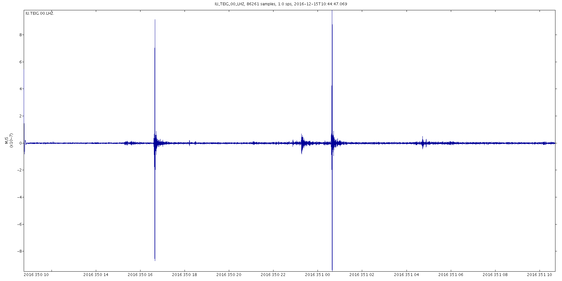
This caught my eye on the USGS Heliplots just now, not often you see two quakes 8 hours apart give or take 27 seconds
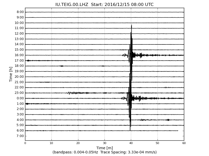
Near Coast of Guatemala
16/12/15 10:34:52 13.164N 90.816W 15.0 4.8ML
16/12/15 18:34:25 12.993N 90.998W 15.7 4.7ML
webserver2.ineter.gob.ni...
shows on the plots right across the Americas from Galapagos Islands to Greenland, but not the southern hemisphere
earthquake.usgs.gov...
noted lots of new stations now, incl Yellowstone
* I just want to test something out on ATS, see what happens.
I just signed up for Pocket, an App that saves whole web pages.
I saved that USGS Heliplot link, want to see if it changes over time, or if the Pocket save is like a time stamp. May be handy to save a point in time.
getpocket.com...
edit on 1200000035035016 by muzzy because: (no reason given)
a reply to: muzzy
aww jeez, muzzy.... you sure you really want to post more of those heliplots?
*chuckles
Ok, fine. Then YOU will be the one responsible for responding to the next 5 million posts claiming seismicity when it is telemetry error.
In the meantime, check out the mega fault, largest exposed in the world, just discovered north of Australia in the Banda Sea:
www.abovetopsecret.com...
a reply to: TrueAmerican
Interesting, Keeping an eye out for activity around "Kepulauan Kai, Indonesia" then.
Interesting, Keeping an eye out for activity around "Kepulauan Kai, Indonesia" then.
a reply to: muzzy
Not as far as I am aware. It saves links to the web pages so if the page dies the link dies as well. If you are using Firefox get Scrapbook. That does save the complete page intact and it is preserved on your computer.
By the way an IMPORTANT announcement from Dropbox [an email] which will affect both you and me.
I believe this means that all your map icons, and mine in the programs, and the links for people to download my programs get zapped. It continues....
That sounds to me like a physical impissibolity as far as your maps are concerned.
BTW they call this an 'improvement'.
Just been to pocket to prove to myself what I am saying was right. One of my pocket links was on a passworded site and pocket could not access it. I believe this proves that all they are doing is saving a link. It is actually little more than a bookmark manager across devices.
I just signed up for Pocket, an App that saves whole web pages.
Not as far as I am aware. It saves links to the web pages so if the page dies the link dies as well. If you are using Firefox get Scrapbook. That does save the complete page intact and it is preserved on your computer.
By the way an IMPORTANT announcement from Dropbox [an email] which will affect both you and me.
As a result, we’ll soon be ending support for the Public folder. Dropbox Basic users will be able to use the Public folder until March 15, 2017. After that date the files in your Public folder will become private, and links to these files will be deactivated. Your files will remain safe in Dropbox.
I believe this means that all your map icons, and mine in the programs, and the links for people to download my programs get zapped. It continues....
If you’d like to keep sharing files in your Public folder, you can create new shared links. Just make sure to send the new URLs to your collaborators.
That sounds to me like a physical impissibolity as far as your maps are concerned.
BTW they call this an 'improvement'.
Just been to pocket to prove to myself what I am saying was right. One of my pocket links was on a passworded site and pocket could not access it. I believe this proves that all they are doing is saving a link. It is actually little more than a bookmark manager across devices.
edit on 16/12/2016 by PuterMan because: (no reason given)
a reply to: TrueAmerican
I am curious TA. What are your grounds for saying it is a telemetry error?
It looks real enough on a time series plot.
Click the image to enlarge
I am curious TA. What are your grounds for saying it is a telemetry error?
It looks real enough on a time series plot.

Click the image to enlarge
a reply to: PuterMan
Lol. No. I am not saying that those particular plots are telemetry error. I was referring in general to this:
www.abovetopsecret.com...
Lol. No. I am not saying that those particular plots are telemetry error. I was referring in general to this:
www.abovetopsecret.com...
new topics
-
A man of the people
Diseases and Pandemics: 53 minutes ago -
Ramblings on DNA, blood, and Spirit.
Philosophy and Metaphysics: 1 hours ago -
4 plans of US elites to defeat Russia
New World Order: 2 hours ago -
Thousands Of Young Ukrainian Men Trying To Flee The Country To Avoid Conscription And The War
Other Current Events: 6 hours ago -
12 jurors selected in Trump criminal trial
US Political Madness: 8 hours ago -
Iran launches Retalliation Strike 4.18.24
World War Three: 9 hours ago -
Israeli Missile Strikes in Iran, Explosions in Syria + Iraq
World War Three: 9 hours ago
top topics
-
George Knapp AMA on DI
Area 51 and other Facilities: 15 hours ago, 26 flags -
Israeli Missile Strikes in Iran, Explosions in Syria + Iraq
World War Three: 9 hours ago, 16 flags -
Louisiana Lawmakers Seek to Limit Public Access to Government Records
Political Issues: 17 hours ago, 7 flags -
Iran launches Retalliation Strike 4.18.24
World War Three: 9 hours ago, 6 flags -
Not Aliens but a Nazi Occult Inspired and then Science Rendered Design.
Aliens and UFOs: 15 hours ago, 5 flags -
Thousands Of Young Ukrainian Men Trying To Flee The Country To Avoid Conscription And The War
Other Current Events: 6 hours ago, 5 flags -
12 jurors selected in Trump criminal trial
US Political Madness: 8 hours ago, 4 flags -
4 plans of US elites to defeat Russia
New World Order: 2 hours ago, 2 flags -
Ramblings on DNA, blood, and Spirit.
Philosophy and Metaphysics: 1 hours ago, 1 flags -
A man of the people
Diseases and Pandemics: 53 minutes ago, 0 flags
active topics
-
12 jurors selected in Trump criminal trial
US Political Madness • 24 • : DAVID64 -
Mood Music Part VI
Music • 3060 • : TheWoker -
4 plans of US elites to defeat Russia
New World Order • 10 • : andy06shake -
Elites disapearing
Political Conspiracies • 32 • : SchrodingersRat -
A man of the people
Diseases and Pandemics • 1 • : chr0naut -
Thousands Of Young Ukrainian Men Trying To Flee The Country To Avoid Conscription And The War
Other Current Events • 3 • : Consvoli -
British TV Presenter Refuses To Use Guest's Preferred Pronouns
Education and Media • 67 • : Consvoli -
The Fight for Election Integrity Continues -- Audits, Criminal Investigations, Legislative Reform
2024 Elections • 4138 • : IndieA -
Fossils in Greece Suggest Human Ancestors Evolved in Europe, Not Africa
Origins and Creationism • 63 • : Consvoli -
Mandela Effect - It Happened to Me!
The Gray Area • 112 • : CCoburn