It looks like you're using an Ad Blocker.
Please white-list or disable AboveTopSecret.com in your ad-blocking tool.
Thank you.
Some features of ATS will be disabled while you continue to use an ad-blocker.

Quake Watch 2016
page: 65share:
a reply to: ericblair4891
Yeah I see that.
The US Naval Research Laboratory are calling it 23W.SONGDA a Tropical Depression, not a typhoon yet.
Will brush the Bonin Islands too (the little white dot at 11 o'clock from the green circle)
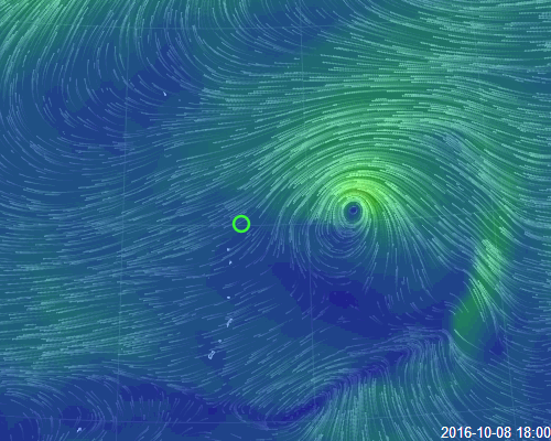
animation from earthwindnullschool maps
the green circle is the location of that 5.6 quake
I posted on Southern Cyclone/Typhoon Watch 2012- as well
been a bit lapse on this Topic, the Western Pacific probably gets more Typhoons (Hurricanes) than anywhere else on the Planet, yet no one is talking about it?
Yeah I see that.
The US Naval Research Laboratory are calling it 23W.SONGDA a Tropical Depression, not a typhoon yet.
Will brush the Bonin Islands too (the little white dot at 11 o'clock from the green circle)
animation from earthwindnullschool maps
the green circle is the location of that 5.6 quake
I posted on Southern Cyclone/Typhoon Watch 2012- as well
been a bit lapse on this Topic, the Western Pacific probably gets more Typhoons (Hurricanes) than anywhere else on the Planet, yet no one is talking about it?
edit on 1000000028128116 by muzzy because: (no reason given)
I went an put the commentators curse on it yesterday
Another 5.8 East Cape Ridge, NI, NZ
www.geonet.org.nz...
a 4.2 and 2 x 4.1 aftershocks, and a few 3's
www.geonet.org.nz... (link will roll over in probably less than 24 hrs)
Seems to have eased off at East Cape muzzy
Another 5.8 East Cape Ridge, NI, NZ
www.geonet.org.nz...
edit on 1000000028128116 by muzzy because: (no reason given)
a 4.2 and 2 x 4.1 aftershocks, and a few 3's
www.geonet.org.nz... (link will roll over in probably less than 24 hrs)
edit on 1000000028128116 by muzzy because: (no reason
given)
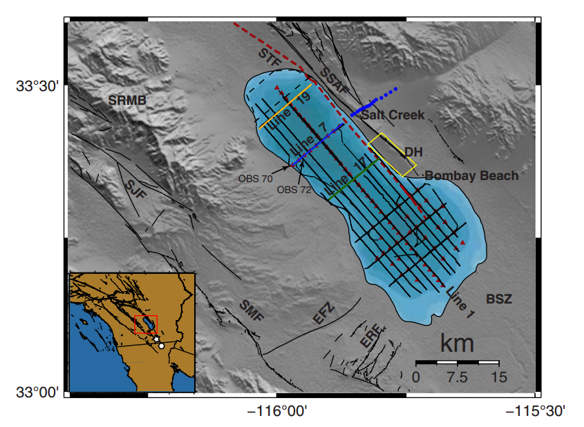
A new underwater fault line in southern California that runs along the Salton Sea and parallel to the San Andreas Fault.
Links:
time.com...
www.foxnews.com...
losangeles.cbslocal.com...
www.bssaonline.org...
Links:
time.com...
www.foxnews.com...
losangeles.cbslocal.com...
www.bssaonline.org...
I have updated the East Cape Ridge, NI, NZ page to reflect todays M5.8 and further M4 aftershocks.
This 5.8 is the most western and the shallowest of all the 14 x mag 5s in this series.
I did an update of the cross-sectional view of Earthquake depths as two graphs, which should be viewed in conjunction with the large map at the top of the page.
These 2 graphs were made when the series had reached 1799 events.
Todays M5.8 is shown as a diamond icon (orange for 5) on both graphs and on the interactive map as a new point of reference.
East Cape Ridge
This one is looking a bit like the last 2 big series I covered, I'm thinking of SW off Kyushu and Kumamoto in Japan.
A gradual downwards trend in the magnitudes over time, then BANG another mid-strong one to kick things off again, before it gradually tails off again.
The time between the resurge varies between the 3 series (East Cape Ridge has been the shortest period)
Could this be the "new normal?"
maybe its just New Zealand and Japan?
maybe it just happens in subduction zones?
it didn't happen on the series I have covered on EQ Archives in other parts of the World
edit on 1000000028228216 by muzzy because: (no reason
given)
a reply to: SeekingDepth
Been working so much, I keep so behind in my study.
Just saw this a couple of days ago,but haven't had time to post.
Very interesting.
That's just another reason they should shut that thermo plant down.
There are so many people in that area, that are so complacent.
When that area does decide to go off, who know what could really happen. It's very Volcanic in that area.
M 4.8 - Off the coast of Oregon
III
DYFI?
Time
2016-10-09 19:08:47 (UTC)
Location
44.278°N 129.362°W
Depth
10.0 km
M 4.1 - Off the coast of Oregon
Time
2016-10-09 18:51:59 (UTC)
Location
44.300°N 129.176°W
Depth
10.0 km
M 4.1 - Off the coast of Oregon
II
DYFI?
Time
2016-10-09 14:18:36 (UTC)
Location
45.078°N 127.876°W
Depth
10.0 km
Three quakes off the Coast of Oregon today,
in less than 5 hours.
4.1, 4.1 & 4.8.
WOQ
Oops! Too slow!
in less than 5 hours.
4.1, 4.1 & 4.8.
WOQ
Oops! Too slow!
edit on 10-10-2016 by wasobservingquietly because: (no reason given)
originally posted by: wasobservingquietly
Three quakes off the Coast of Oregon today,
in less than 5 hours.
4.1, 4.1 & 4.8.
WOQ
Oops! Too slow!
Stands out, don't it. Hope that's the end of that.
2016 10 10 15 3 28.0 -15.25 -175.25 33.0 4.8 TONGA ISLANDS
2016 10 10 13 16 16.0 -15.25 -175.25 33.0 5.3 TONGA ISLANDS
2016 10 10 10 43 4.0 -15.00 -175.00 33.0 5.3 TONGA ISLANDS
2016 10 10 9 46 16.0 -15.00 -175.00 33.0 5.2 TONGA ISLANDS
2016 10 10 8 35 20.0 -15.00 -175.00 33.0 5.7 TONGA ISLANDS
2016 10 9 23 23 52.0 -16.25 -174.25 33.0 4.8 TONGA ISLANDS
www.ldeo.columbia.edu...
double post, stupid reply button wouldn't post it
edit on 1000000028328316 by muzzy because: (no reason given)
triple post, stupid reply button wouldn't post it
sorry about that, proably a W10 fault
sorry about that, proably a W10 fault
edit on 1000000028328316 by muzzy because: (no reason given)
a reply to: muzzy
I you double or triple post, you need to add a picture or a funny video. Don't you recycle?
Maybe, I wouldn't be so critical of fracking if they reused the wastewater. effers.
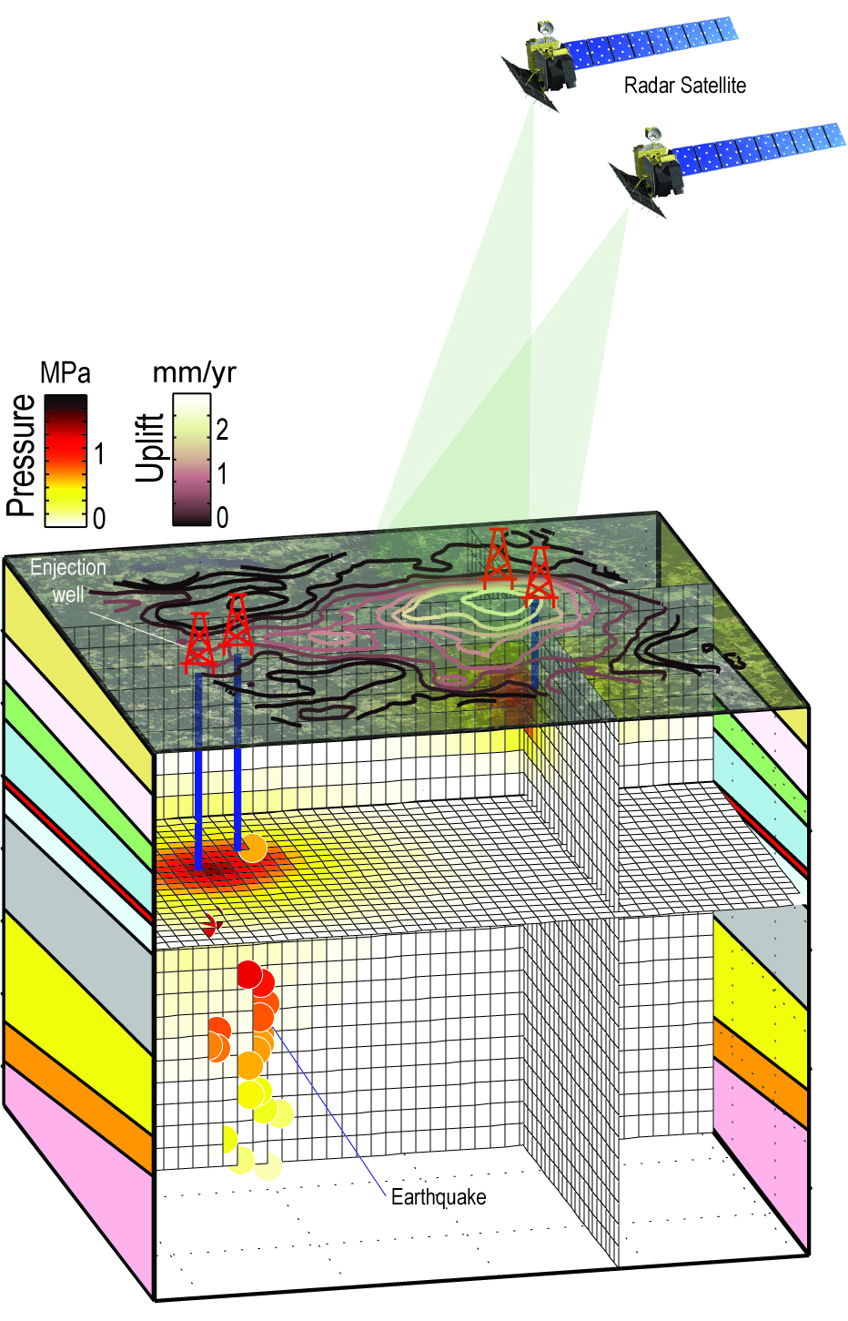
Now there is direct evidence of induced earthquakes. They caught the ground moving directly under the pressure pump.
I mean it's obvious to us, but, when you show something but recording specific data points, it proves the case beyond any shadow of doubt.
www.azpm.org...
I you double or triple post, you need to add a picture or a funny video. Don't you recycle?
Maybe, I wouldn't be so critical of fracking if they reused the wastewater. effers.
Now there is direct evidence of induced earthquakes. They caught the ground moving directly under the pressure pump.
I mean it's obvious to us, but, when you show something but recording specific data points, it proves the case beyond any shadow of doubt.
www.azpm.org...
further to: muzzy
same area, and different name, but way deeper than those other "Tonga Region" ones, which GFZ showed as 10km (LDEO always say 33km) both default depths because they don't know for sure. 10-33km is "shallow"
2016-10-11 05:37:26 5.0 17.50°S 178.37°W 534 C Fiji Islands Region
geofon.gfz-potsdam.de...
seen these too, shallow
F-E Region: Greece
Time: 2016-10-11 11:48:31.2 UTC
Magnitude: 4.5 (mb)
Epicenter: 21.82°E 38.42°N
Depth: 7 km
Status: C - confirmed
geofon.gfz-potsdam.de...
(collapsed coal mine or blast?)
F-E Region: Poland
Time: 2016-10-10 15:40:54.8 UTC
Magnitude: 3.2 (MLv)
Epicenter: 16.26°E 51.51°N
Depth: 1 km
Status: M - manually revised
geofon.gfz-potsdam.de...
edit on 1000000028428416 by muzzy because: (no reason given)
speaking about depth.
I usually don't bother much with depth, except when something extreme jumps out at me.
Sure I look at local ones around where I live, usually to see why I didn't feel them, often they are at 60km or so around here, which is fairly deep and we hardly feel those below M4.5
But I'm going to run some NZ depth graphs for a while, I started with East Cape Ridge last week and found it quite informative when the figures turned into a S-N Lat/Long/Depth graph.
here is one I did for NZ 09/10/2016
rightclickviewimageforfullsize
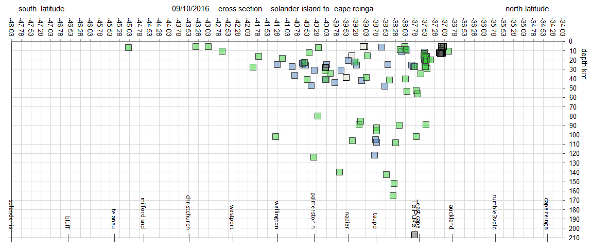
I'm going to 200km as the max at the moment, but I know we do get some under Taranaki at 600km sometimes.
I think you all know the layout of NZ, its pretty much N to S and W to E
As far as a Longitude based graph I can't figure out how to run the Y axis in both +/- Longitudes, ie past East Cape Ridge we are into the - Longitudes, due to the Antimeridian Line,
So all I could do is maybe 2 seperate W-E graphs, one across the North Island (always busy) and another one across Fiordland (when there are enough events to plot).
Christchurch isn't worth graphing as they are all 5-11km.
I usually don't bother much with depth, except when something extreme jumps out at me.
Sure I look at local ones around where I live, usually to see why I didn't feel them, often they are at 60km or so around here, which is fairly deep and we hardly feel those below M4.5
But I'm going to run some NZ depth graphs for a while, I started with East Cape Ridge last week and found it quite informative when the figures turned into a S-N Lat/Long/Depth graph.
here is one I did for NZ 09/10/2016
rightclickviewimageforfullsize
I'm going to 200km as the max at the moment, but I know we do get some under Taranaki at 600km sometimes.
I think you all know the layout of NZ, its pretty much N to S and W to E
As far as a Longitude based graph I can't figure out how to run the Y axis in both +/- Longitudes, ie past East Cape Ridge we are into the - Longitudes, due to the Antimeridian Line,
So all I could do is maybe 2 seperate W-E graphs, one across the North Island (always busy) and another one across Fiordland (when there are enough events to plot).
Christchurch isn't worth graphing as they are all 5-11km.
edit on 1000000028428416 by muzzy because: (no reason given)
Antarctica Plate doing its spinning/expanding thing again?
2016 10 11 5 28 32.0 -63.25 -158.75 33.0 5.1 PACIFIC-ANTARCTIC RIDGE
2016 10 11 5 4 48.0 -54.75 1.75 33.0 5.0 BOUVET ISLAND REGION
2016 10 11 2 35 12.0 -59.25 158.25 33.0 4.8 MACQUARIE ISLAND REGION
www.ldeo.columbia.edu...
2016 10 11 5 28 32.0 -63.25 -158.75 33.0 5.1 PACIFIC-ANTARCTIC RIDGE
2016 10 11 5 4 48.0 -54.75 1.75 33.0 5.0 BOUVET ISLAND REGION
2016 10 11 2 35 12.0 -59.25 158.25 33.0 4.8 MACQUARIE ISLAND REGION
www.ldeo.columbia.edu...
Here is an unusual one, south of India
F-E Region: Laccadive Sea
Time: 2016-10-11 22:30:55.0 UTC
Magnitude: 5.2
Epicenter: 75.92°E 5.32°N
Depth: 10 km
Status: C - confirmed
geofon.gfz-potsdam.de...
F-E Region: Laccadive Sea
Time: 2016-10-11 22:30:55.0 UTC
Magnitude: 5.2
Epicenter: 75.92°E 5.32°N
Depth: 10 km
Status: C - confirmed
geofon.gfz-potsdam.de...
Having a few problems with the NZ Topo maps on nzeq2016, eqarchives and japanquakes not showing all the icons the last 2 days
I hope they are not going to crash like Google and Bing did and that it is just something temporary.
I'll have to think up some other way to present the maps, just in case this is the end.
And it may not be interactive
I hope they are not going to crash like Google and Bing did and that it is just something temporary.
I'll have to think up some other way to present the maps, just in case this is the end.
And it may not be interactive
edit on 1000000028428416 by muzzy because: (no reason given)
new topics
-
George Knapp AMA on DI
Area 51 and other Facilities: 5 hours ago -
Not Aliens but a Nazi Occult Inspired and then Science Rendered Design.
Aliens and UFOs: 5 hours ago -
Louisiana Lawmakers Seek to Limit Public Access to Government Records
Political Issues: 7 hours ago -
The Tories may be wiped out after the Election - Serves them Right
Regional Politics: 8 hours ago -
So I saw about 30 UFOs in formation last night.
Aliens and UFOs: 10 hours ago -
Do we live in a simulation similar to The Matrix 1999?
ATS Skunk Works: 11 hours ago
top topics
-
BREAKING: O’Keefe Media Uncovers who is really running the White House
US Political Madness: 12 hours ago, 24 flags -
George Knapp AMA on DI
Area 51 and other Facilities: 5 hours ago, 19 flags -
Biden--My Uncle Was Eaten By Cannibals
US Political Madness: 13 hours ago, 18 flags -
Louisiana Lawmakers Seek to Limit Public Access to Government Records
Political Issues: 7 hours ago, 7 flags -
"We're All Hamas" Heard at Columbia University Protests
Social Issues and Civil Unrest: 13 hours ago, 7 flags -
Russian intelligence officer: explosions at defense factories in the USA and Wales may be sabotage
Weaponry: 17 hours ago, 6 flags -
So I saw about 30 UFOs in formation last night.
Aliens and UFOs: 10 hours ago, 5 flags -
The Tories may be wiped out after the Election - Serves them Right
Regional Politics: 8 hours ago, 3 flags -
Not Aliens but a Nazi Occult Inspired and then Science Rendered Design.
Aliens and UFOs: 5 hours ago, 3 flags -
Do we live in a simulation similar to The Matrix 1999?
ATS Skunk Works: 11 hours ago, 3 flags
active topics
-
Two Serious Crimes Committed by President JOE BIDEN that are Easy to Impeach Him For.
US Political Madness • 15 • : WeMustCare -
Not Aliens but a Nazi Occult Inspired and then Science Rendered Design.
Aliens and UFOs • 8 • : theatreboy -
I Guess Cloud Seeding Works
Fragile Earth • 25 • : Degradation33 -
-@TH3WH17ERABB17- -Q- ---TIME TO SHOW THE WORLD--- -Part- --44--
Dissecting Disinformation • 534 • : cherokeetroy -
The US Supreme Court Appears to Side With the January 6th 2021 Capitol Protestors.
Political Conspiracies • 48 • : hoobah -
BREAKING: O’Keefe Media Uncovers who is really running the White House
US Political Madness • 11 • : BingoMcGoof -
Elites disapearing
Political Conspiracies • 28 • : hoobah -
African "Newcomers" Tell NYC They Don't Like the Free Food or Shelter They've Been Given
Social Issues and Civil Unrest • 14 • : GENERAL EYES -
God is watching.
Politicians & People • 28 • : glend -
George Knapp AMA on DI
Area 51 and other Facilities • 19 • : Brotherman