It looks like you're using an Ad Blocker.
Please white-list or disable AboveTopSecret.com in your ad-blocking tool.
Thank you.
Some features of ATS will be disabled while you continue to use an ad-blocker.

Quake Watch 2016
page: 63share:
Eric, I have been thinking about your Weather/Quakes relationship question and how we can monitor this?
The Earth Wind Weather visualization of global weather conditions forecast by supercomputers updated every three hours may be a helpful tool. In fact even our TV station has changed its nightly forecasts using a similar layout, with the swirling wind currents, I'm not sure if they are using the nullschool program itself or have developed their own.
earth.nullschool.net.../wind/surface/level/overlay=mean_sea_level_pressure/equirectangular
So the link above shows Mean Sea Level Pressure, which might be the one layer that has the most relevant details pertaining to earthquakes, not so much the wind or the rain but the hPa pressure at the Earths surface.
Its early days yet to draw conclusions, we need to monitor it for a few weeks to see if there is any relationship with quakes.
Right now, based on the map I linked to, there should/could be heightened quake activity in the following regions
(click on the map with your cursor and the Lat/Long with the hPa will show on a box in the bottom left of your screen)
Ryukyu Islands Japan 986hPa
Hokkaido/Southern Kuril Is 995hPa
Western Aleutian Is 988hPa
Offshore British Columbia/ S of Alaska 994hPa
Prairies (Yellowstone/Idaho) 995hPa
West of Hudson Bay Canada 991hPa
North Atlantic, Iceland 967hPa
Caribbean 992Pa
South of Australia, extending to NZ 962hPa at lowest
Pacific Antarctic Ridge (between NZ and South America) 957hPa
that is looking at the whole map, double clicking will take you in closer, there will be more detailed readings
Looking at the map overall the dark purple patches are high risk of storms, but not all will be earthquake relevant, such as the whole of the Southern Ocean, Tropical Brazil, Tropical Africa, North Pole.
Burgundy coloured areas are strong storms, hurricanes, cyclones, typhoons etc
So thats a start, lets keep an eye on that and compare what happens with worldwide earthquakes over the next 24 hrs and see what happens. Later I might have a go and overlay a global earthquake events plot over the EarthWind map
Eric mentioned that quake the other day Mid Atlantic Ridge was right under a depression/storm, I had a look using EarthWind (lets call it that?, the program is just called "earth" but it doesn't really describe what it actually is) an clicked and scrolled until I had the quake location marked on the EarthWind map (the green circle) and while the storm never actually passed over the epicenter within 3 hours either side of the quake event time, the perimeter edges did, and even at that distance the hPa was in the 900's.
I'll put the EarthWind link in my signature, for easier access.
edit on 1000000027627616 by muzzy because: (no reason given)
One reason I have latched onto this hPa thing is that I had been reading a few months ago about historic (1800's) Philippine earthquakes, recorded by
an expat living there. Many of the big quakes of that period coincided with Typhoons, so many times in fact that the records got a bit confusing as to
whether the devastation he recorded was caused by the Typhoon or by the Earthquake.
Also I have noticed that we do get quakes (high4's and 5's) here in NZ sometimes when a storm is passing over, not always, but enough times that I thought at the time "oh yeah, Storm=Quake"
here is the report I was reading over(as part of research for my Significant Earthquakes 6.5+ mapping project)
Catalogue of Philppine Earthquakes 1589-1983
Garcia is the expat I mentioned
I have put the PDF on Dropbox
dl.dropboxusercontent.com...
It makes for interesting reading (if you are into historic earthquakes)
I find it mind boggling that any of these historic earthquake prone places, like Turkey, China, Japan, Syria, Philippines survived the cumulative devestation over time
LOL I just noticed that I put the graphs for Japan on the NZ page for 29.09.2016 on my blog.
Trying to cover too much at once?
I have started using a NZ map again for the thumbnail on nzquakes.
It's easy enough when I have the day off due to weather or its the weekend, but a bit of a mission to get both done in a timely manner at other times.
I'll fix that later
Trying to cover too much at once?
I have started using a NZ map again for the thumbnail on nzquakes.
It's easy enough when I have the day off due to weather or its the weekend, but a bit of a mission to get both done in a timely manner at other times.
I'll fix that later
I see we've had another one near Yellowstone, one over in Oregon, a couple in Nevada, and now Southern Cali is lighting up. From Northridge/Tarzana to
south of Salton Sea, this part of the Golden State seems to be, uh, quivering? This weird anxiety I have reminds me of 2005.
It was days before Hurricane Katrina hit land...people were still wondering about her exact path....I had an ugly, weird feeling. I couldn't figure out what was triggering it. My mother wasn't in town visiting, so I knew it couldn't be that. And what I saw in my mind's eye could only be described to my spouse as such: "Imagine if I built a Lego/Lincoln Log village in the bathtub, right? Lots of little tiny houses all over the bottom of the tub. Now imagine if we fill it with just about 2-3 inches of water. And when we look down at the village, we can only see the ROOFS above the water." So we waited. And watched. Then. Ya know.
So here I am again. Feeling that ugly weird feeling. Maybe it's gas, maybe PMS...maybe the moon, maybe I ate something expired. Nonetheless. Stuff is starting to move here, and I'm trying to remain calm.
a reply to: muzzy
Thought I pop my head in on this one, In regards to weather and earthquakes.
A link between Erosion and EQ's has fascinated me for sometime now. The displacement of large mass of water could change the stresses on the faults as it rapidly fills the aquifers and moves large quantities of sediment from one stress point to the other. Likewise rapid cooling or heating breaking cracking rocks allowing landslides to shift the stress points if a fault.
I found this article that sheds more light on weather erosion and earthquakes. link
I wish I had more time to research this stuff. I always appreciate your post and insight.
Thank you.
Thought I pop my head in on this one, In regards to weather and earthquakes.
A link between Erosion and EQ's has fascinated me for sometime now. The displacement of large mass of water could change the stresses on the faults as it rapidly fills the aquifers and moves large quantities of sediment from one stress point to the other. Likewise rapid cooling or heating breaking cracking rocks allowing landslides to shift the stress points if a fault.
I found this article that sheds more light on weather erosion and earthquakes. link
Recent work has shown that Earth's surface can undergo major changes in just a few days, months or years, for instance during extreme events such as typhoons or high magnitude earthquakes. Such events cause many landslides and an increase in sedimentary transport into rivers, as was the case in 2009 when typhoon Morakot struck Taiwan, leading to abrupt erosion of landscapes. Such rapid changes to the shape of Earth's surface alter the balance of forces at the site of deep active faults.
The researchers have thus shown that plate tectonics is not the only persistent mechanism able to influence the activity of seismic faults, and that surface processes such as erosion and sedimentation can increase stresses on active faults sufficiently to cause shallow earthquakes.
I wish I had more time to research this stuff. I always appreciate your post and insight.
Thank you.
edit on 4-10-2016 by Observationalist because: (no reason given)
Duplicate post
edit on 4-10-2016 by Observationalist because: (no reason given)
Did a small one (or two) just pop off ON the San Andreas? Looks like it.
a reply to: HollywoodFarmGirl
I'm not seeing it yet?? Where is it do you have a link?
I have noticed Oklahoma.
M 3.1 - 13km NNW of Stroud, Oklahoma
IV
DYFI?
Time
2016-10-04 13:10:44 (UTC)
Location
35.864°N 96.689°W
Depth
9.3 km
And...
M 3.5 - 16km NW of Pawnee, Oklahoma
IV
DYFI?
IV
ShakeMap
Time
2016-10-04 09:10:38 (UTC)
Location
36.431°N 96.945°W
Depth
7.6 km
earthquake.usgs.gov...
a reply to: HollywoodFarmGirl
hahahaha... Oh how do I feel your anxiety. Wondering the same thing.
hahahaha... Oh how do I feel your anxiety. Wondering the same thing.
Feeling that ugly weird feeling. Maybe it's gas, maybe PMS...maybe the moon, maybe I ate something expired. Nonetheless. Stuff is starting to move here, and I'm trying to remain calm.
a reply to: muzzy
Thank you!!!!!! Thank you Eric/Robin!!!! This will be interesting to see what you find.
So thats a start, lets keep an eye on that and compare what happens with worldwide earthquakes over the next 24 hrs and see what happens. Later I might have a go and overlay a global earthquake events plot over the EarthWind map
Thank you!!!!!! Thank you Eric/Robin!!!! This will be interesting to see what you find.
a reply to: muzzy
Ha ha. I just finished looking at Nullschool wind map when I found on in the mid-Atlantic. The winds were interesting, but it wasn't a hurricane or depression. The winds were coming from two directions. Then I checked the satellite, and sure enough, there was a storm. Actually, it was the tail end of a much bigger storm.
I agree pressure will be important. But necessarily the whole thing. Since there are different kinds and not all rotate. The pressure will allow the water below to expand upward. So, before the low pressure gets to wherever the epicenter is, it has already push ahead of itself, surge of water the will be pressing downward. The low pressure comes along, and is lifted up, and the as passed over, the following waves will again push down. So, there is a undulation on ocean floor. And we must remember, this thin crust pizza out there in the ocean. And water is massive and heavy.
But, I also think the wind is very important. Because it can preceded the storm and strong winds will cause surges. Just like in a hurricane. Also, I think in certain situation, strong waves hit a shoreline could stress and set off a nearby fault. And, I hate to say it, the tides and moon will factor in how the waves and the underground will have risen putting lots of pressure into a system. I'll refer back to Ecuador. They tons of rain storms before the fact, and then when the tide rose, it set off a big one.
Right now, I'm just using the maps and seeing what storm is where. Muzzy your the man with graphs and maps and I'm glad you're taking it seriously. After all, we're both watching the same planet and seeing the same patterns. But as for the technical side, I don't like. I like graphs. Because that's visual. I'm a map geek. That's why I like tracking earthquakes. It lets me explore the world. So, I can help, but I'm limited to watch, and ranting about my observations.
I'm so glad that we are starting to see, that water is often part of the earthquakes dynamic. In more ways than one.
Oh, and there is a cyclone near Japan. And of course, there are earthquakes near Japan. However, there's almost always an earthquake near Japan, and especially lately, it seems to constant. And so have the storms in area. Really. There's been a conveyor belt of storms that have been crashing in China.
I don't know
Yellowstone had few on the east side. Salton looks quiet with only a few new ones off to the southwest. Stupid geo plant. I can't get over that. Stupid stupid stupid.
Oh, that stupid movie 10.0 Earthquake, had a similar stupid plot, frackers drill too deep and the whole valley shatters like glass bowl. I think that's how they described it. I'm sure the geo plant is totally safe.
sarcasm
Had to add. I must admit, I am a sloppy researcher. For example, I never checked the time of the earthquake in mid-Atlantic. I just woke up and stupid. So, I went back, checked, and sure enough, it didn't just happen. It happen many hours ago, when, the biggest part of that storm was right over top.
oh, and just because Yellowstone is burping, I went and checked the uplift/subsidence. Norris is up, and I think, leveling off. Last time it rose so quickly, there was a goodly swarm and a sudden subsidence. And then it rose the same way this time. So, I think there must be a swarm and then a subsidence. The caldera itself has went back to slowly rising or level. But I think it's clear it's not subsiding anymore.
Had to add. And I thought the wind map was hypnotic. Holy. Yes Muzzy, the pressure will be the thing to follow, because storms and low pressure usually go together. And, the wind is usually strongest when flowing toward the low pressure.
Here's another thing. Storms at sea and around Island will be different than storm on or near land. On land, there may be a delay. As the rain that the low pressure brings, needs to peculate down. Erosion, etc... The crust will not warp in the same way under the sea. The thin crust of the Atlantic is under a gigantic ocean.
Also, not all storms and low pressure bring earthquakes. It will have to depend on the condition of the fault. It's near rupture point, a storm could easily trigger it. But, it fault recently have removed stress from earthquakes, a massive storm can pass over and nothing happens. Again, the water doesn't cause the tectonic stress, it aggravates the stress and trigger the rupture. So, just like the tides and such, there will be a statistical difference. So, storms increase the risk of earthquakes.
For example, right now there is a low pressure near Madagascar. And recently, Africa has been busyish. Will there be an earthquake. Maybe not. Because, the last earthquake in the area may have alleviated stress. I don't remember if I checked for storms then. So, this storm may pass over and nothing.
In north Atlantic, there's a storm, but quakes.
Had to add. I'm bad researcher. I haven't even considered the volcanoes. Mexican and Central American volcanoes are having some fun. So, is this a build up for something. But, I am lazy and fell off Mexico and haven't tracked it much. So, I can't even give an opinion and it's behaviour.
Colima looks exciting.
etc
edit on 4-10-2016 by ericblair4891 because: (no reason given)
a reply to: ericblair4891
As it happens I follow Weather almost equally obsessively as I do Earthquakes (because of my work)
And coincidentally when I first started following earthquakes in 2006 I was taking a screenshot of the NZ satellite map each day as well as plotting the earthquakes for NZ, and the World too
here is my post for today 10 years ago.
Have come a long way with the technology since then (and then gone backwards since Feb 2015 due to the Google Maps and Bing Maps dropping their interactive programs)
edit on 1000000027727716 by muzzy because: (no reason given)
a reply to: muzzy
I tried to find some stuff on the ocean floor and pressure. The only thing they seem to concerned with is how waves can be shaped by the sea floor. And other factors such circulation and such. I can't find anything on how the crust behaves. They have some sensor on the floor and studying micro quakes and faults, but I don't see anything on how the mass of the ocean effects the crust. Maybe someone else can find something. Or maybe, geophysicist think the crust doesn't move except the plates and the faults.
I tried to find some stuff on the ocean floor and pressure. The only thing they seem to concerned with is how waves can be shaped by the sea floor. And other factors such circulation and such. I can't find anything on how the crust behaves. They have some sensor on the floor and studying micro quakes and faults, but I don't see anything on how the mass of the ocean effects the crust. Maybe someone else can find something. Or maybe, geophysicist think the crust doesn't move except the plates and the faults.
a reply to: ericblair4891
Here's another problem with trying to link weather and earthquakes. Just now, in Alaska. 4.3M. It's not big. There was a line of storms that just passed over the epicenter. So, there's an earthquake and a storm in the same area. However, Alaska is stormy and Alaska is earthquakey. And I definitely can't say the stormy weather is causing all the earthquakes. Ah, maybe I could. Just joking.
Here's another problem with trying to link weather and earthquakes. Just now, in Alaska. 4.3M. It's not big. There was a line of storms that just passed over the epicenter. So, there's an earthquake and a storm in the same area. However, Alaska is stormy and Alaska is earthquakey. And I definitely can't say the stormy weather is causing all the earthquakes. Ah, maybe I could. Just joking.
a reply to: ericblair4891
That's the problem, how many big quakes occurred when there were no storms? probably more than those with storms.
Places like Iran, China, Turkey come to mind.
Not all big quakes are under the sea, although a heck of lot are.
Some of those storms are REALLY big and encompass whole bunches of countries ( eg Caribbean)
I was waiting for that Alaska one, but it quite small and way out on the edge of the storm.
As you say Alaska/Aluetains could go at any time anyway, doesn't need a storm for it to shake there.
Muzzys Historic Quake of the Day
Date/Time: 1870/10/20 16:30:;
Lat: 47.4 Long: -70.5;
Location: Southern Quebec. Canada;
Magnitude: 6.55Mw SCHULTEandMOONEY; 6.5ML LAMONTAGNE et al; 6.5mb GSC; 6.6Mw SCHULTEandMOONEY; 5.8Mw EBEL et al; ;
Depth: km;
Deaths: ; Injuries: ;Tsunami: ;
Catalog Source: SCHULTEandMOONEY; "The St. Lawrence depression, Canada, besides being an ancient rift, is also the site of a major collisional suture" onlinelibrary.wiley.com...
map
1870? probably not much around the St Lawrence River at that time except beavers, indians and trappers.
It might be a different story if one that size hit there today, Quebec City and Saguenay about equal distance away.
*I might do this again as I re-write the M6,5_project for the 2nd time, now using ikimaps.
I hope ikimaps sticks around, I won't be doing this a 3rd time.
Looking through the other maps that other people have loaded quite a few of them have 100-150 maps, I'm looking at having 1000 of them, if I ever finish this.
Hello Earthquake watching friends.
It is a happy day. There is a new version of GEE, the Global Earthquake Explorer, available for download.
It is a happy day. There is a new version of GEE, the Global Earthquake Explorer, available for download.
Salton Sea is at it again. two over 3M. Not in the same spot as the big swarm. This is at the south end near the origin of the earliest swarm area.
Right under the geothermal plant. Maybe they caused the earthquakes.
The first one was 3.4M the second 3M
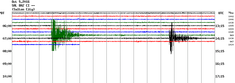
Alaska had 4.5M and there was a storm on top.
Oh, and the earthquakes at Salton are right underneath the geo plant. They must be causing the earthquakes.
They are. Here's a study that proves it.
news.ucsc.edu...
"An analysis of earthquakes in the area around the Salton Sea Geothermal Field in southern California has found a strong correlation between seismic activity and operations for production of geothermal power, which involve pumping water into and out of an underground reservoir.
"We show that the earthquake rate in the Salton Sea tracks a combination of the volume of fluid removed from the ground for power generation and the volume of wastewater injected."
I really stop writing. Because I'm laughing and I shouldn't be. If read the study, and use, um, I think called a brain, you may be able to do some simple math. Let's see, they are, injecting water, and causing earthquakes, on a giant fault. I mean, it's it obvious, it's not a smart thing to do.
""It's hard to draw a direct line from the geothermal field to effects on the San Andreas fault, but it seems plausible that they could interact," Brodsky said."
They are stressing the aquifer as well. They are draining it dry, and filling with waste water. Where is the waste water coming. I bet it's old fracking water.
I found another report that says they aren't using waste water. They use the same water. And try to keep a net balance. Well, at least they're not completely stupid and are pumping excess water in the system.
"The energy production techniques differ considerably in the two regions. In the oilfields of Oklahoma, for example, the wastewater produced during oil recovery and injected back into the ground "increases the volume of fluids significantly at depth" Llenos said. "But for geothermal energy production, the field operators try to maintain a net fluid balance." In some fields, almost 90 percent of the fluids used in geothermal production get injected back into the ground shortly after they are extracted, Llenos noted."
phys.org...
Another
www.theguardian.com...
Pumping water underground could trigger major earthquake, say scientists
I am convinced, the geo plant is responsible for the swarms. This morning, under the plant, there's been 5 earthquakes. Then after a bit, three small ones show in the middle of sea at the second swarm site. Call and respond. The idiots are triggering earthquakes, and these earthquakes are setting off the other fault. That's why they issued the alert in the Governor's office, they know the plant is causing earthquakes. So, if they don't stop, they'll be committing criminal negligence.
The first one was 3.4M the second 3M
Alaska had 4.5M and there was a storm on top.
edit on 5-10-2016 by ericblair4891 because: (no reason given)
Oh, and the earthquakes at Salton are right underneath the geo plant. They must be causing the earthquakes.
They are. Here's a study that proves it.
news.ucsc.edu...
"An analysis of earthquakes in the area around the Salton Sea Geothermal Field in southern California has found a strong correlation between seismic activity and operations for production of geothermal power, which involve pumping water into and out of an underground reservoir.
"We show that the earthquake rate in the Salton Sea tracks a combination of the volume of fluid removed from the ground for power generation and the volume of wastewater injected."
I really stop writing. Because I'm laughing and I shouldn't be. If read the study, and use, um, I think called a brain, you may be able to do some simple math. Let's see, they are, injecting water, and causing earthquakes, on a giant fault. I mean, it's it obvious, it's not a smart thing to do.
""It's hard to draw a direct line from the geothermal field to effects on the San Andreas fault, but it seems plausible that they could interact," Brodsky said."
They are stressing the aquifer as well. They are draining it dry, and filling with waste water. Where is the waste water coming. I bet it's old fracking water.
I found another report that says they aren't using waste water. They use the same water. And try to keep a net balance. Well, at least they're not completely stupid and are pumping excess water in the system.
"The energy production techniques differ considerably in the two regions. In the oilfields of Oklahoma, for example, the wastewater produced during oil recovery and injected back into the ground "increases the volume of fluids significantly at depth" Llenos said. "But for geothermal energy production, the field operators try to maintain a net fluid balance." In some fields, almost 90 percent of the fluids used in geothermal production get injected back into the ground shortly after they are extracted, Llenos noted."
phys.org...
Another
www.theguardian.com...
Pumping water underground could trigger major earthquake, say scientists
I am convinced, the geo plant is responsible for the swarms. This morning, under the plant, there's been 5 earthquakes. Then after a bit, three small ones show in the middle of sea at the second swarm site. Call and respond. The idiots are triggering earthquakes, and these earthquakes are setting off the other fault. That's why they issued the alert in the Governor's office, they know the plant is causing earthquakes. So, if they don't stop, they'll be committing criminal negligence.
edit on 5-10-2016 by ericblair4891 because: (no reason given)
a reply to: Olivine
How the heck do you open the Installer?
It doesn't open the usual way with a "open" to click on and start the installer.
I tried 7-zip and that didn't have and installer in the files either.
I'm on W10.
I see that "due to funding issues and lack of developer resources, GEE will no longer be updated."
that looks like the kiss of death to me.
I'm feeling brain. So, I'm not surprised I've scratching my head and feeling stupid, and I don't trust my memory. I even went back to 2012 on
Quakewatch and realized I said nothing about the Brawley earthquake swarm. I couldn't figure out I hadn't investigated deeper. Then I realized, I was
off line. Bad time. So, I didn't write about it.
The reason I writing now is that is really quiet. Yes, there have things to watch. But today, I felt like I was missing something.
But what's missing, is earthquakes. Yes, I've been excited to watch Salton etc,. However, I started checking and Nevada is super quiet. Yellowstone just shut off. California is kinda the same. Then, I thought, no it's the whole world. I checked map, I usually give a care about weekly averages and the 4.M and above for seven days, often I like to watch little swarms. So, I looked and you bet, there has not been an earthquake over 6. I've noticed area that have had some, they always do, but there, the magnitudes barely go over 5.5M. There's only two at 5.7
I don't what it means if anything. I'm just saying it's really quiet.
the last 6 was nine days in Japan, 6.0 and we did have a two big ones at Fiji and Tonga. 6.9 and and 6.4 and clustered with 30 minute window 11 days ago. just sayin
edit on 5-10-2016 by ericblair4891 because: (no reason given)
new topics
-
VERY IMPORTANT..............
2024 Elections: 18 minutes ago -
Biden--My Uncle Was Eaten By Cannibals
US Political Madness: 25 minutes ago -
"We're All Hamas" Heard at Columbia University Protests
Social Issues and Civil Unrest: 26 minutes ago -
The good, the Bad and the Ugly!
Diseases and Pandemics: 2 hours ago -
Russian intelligence officer: explosions at defense factories in the USA and Wales may be sabotage
Weaponry: 4 hours ago -
African "Newcomers" Tell NYC They Don't Like the Free Food or Shelter They've Been Given
Social Issues and Civil Unrest: 5 hours ago -
Russia Flooding
Other Current Events: 7 hours ago -
MULTIPLE SKYMASTER MESSAGES GOING OUT
World War Three: 7 hours ago -
Two Serious Crimes Committed by President JOE BIDEN that are Easy to Impeach Him For.
US Political Madness: 8 hours ago -
911 emergency lines are DOWN across multiple states
Breaking Alternative News: 8 hours ago
top topics
-
Go Woke, Go Broke--Forbes Confirms Disney Has Lost Money On Star Wars
Movies: 15 hours ago, 13 flags -
Pro Hamas protesters at Columbia claim hit with chemical spray
World War Three: 11 hours ago, 11 flags -
Elites disapearing
Political Conspiracies: 13 hours ago, 9 flags -
African "Newcomers" Tell NYC They Don't Like the Free Food or Shelter They've Been Given
Social Issues and Civil Unrest: 5 hours ago, 8 flags -
Freddie Mercury
Paranormal Studies: 15 hours ago, 7 flags -
911 emergency lines are DOWN across multiple states
Breaking Alternative News: 8 hours ago, 6 flags -
Two Serious Crimes Committed by President JOE BIDEN that are Easy to Impeach Him For.
US Political Madness: 8 hours ago, 5 flags -
A Personal Cigar UFO/UAP Video footage I have held onto and will release it here and now.
Aliens and UFOs: 13 hours ago, 5 flags -
Former NYT Reporter Attacks Scientists For Misleading Him Over COVID Lab-Leak Theory
Education and Media: 10 hours ago, 4 flags -
Biden--My Uncle Was Eaten By Cannibals
US Political Madness: 25 minutes ago, 4 flags
active topics
-
Russian intelligence officer: explosions at defense factories in the USA and Wales may be sabotage
Weaponry • 105 • : BernnieJGato -
VERY IMPORTANT..............
2024 Elections • 3 • : DAVID64 -
Biden--My Uncle Was Eaten By Cannibals
US Political Madness • 5 • : CarlLaFong -
Nirvana - Immigrant Song
Music • 8 • : PHYSIC2X -
Go Woke, Go Broke--Forbes Confirms Disney Has Lost Money On Star Wars
Movies • 17 • : PHYSIC2X -
A Personal Cigar UFO/UAP Video footage I have held onto and will release it here and now.
Aliens and UFOs • 11 • : PHYSIC2X -
Elites disapearing
Political Conspiracies • 24 • : PHYSIC2X -
Pro Hamas protesters at Columbia claim hit with chemical spray
World War Three • 13 • : PHYSIC2X -
Russia Flooding
Other Current Events • 5 • : Hakaiju -
"We're All Hamas" Heard at Columbia University Protests
Social Issues and Civil Unrest • 0 • : FlyersFan