It looks like you're using an Ad Blocker.
Please white-list or disable AboveTopSecret.com in your ad-blocking tool.
Thank you.
Some features of ATS will be disabled while you continue to use an ad-blocker.

Quake Watch 2016
page: 52share:
a reply to: PuterMan
The excercise was based on a M9 at the Kermadec Trench
I don't know if that is possible, the biggest recorded quake there has been a 7.9 and that was further towards Tonga, in 2006. tsunami warnings were issued, but then lifted for that one.
But I bet this morning everyone involved in the Tsunami Exercise will be telling each other how relevant what they were doing was, which is true.
Sort of a reality check, here's a big one just to get your message home.
It will probably be all over the media today.
They had the kids out of class and opened the Civil Defense Operations room in Wellington for it, but how worth while it was won't be known till a tsunami hits, to be honest I still don't know where the evacuation point is for us here where we live in the new suburb.
Generally speaking we are not prepared at all, don't even have sirens along the coast like the Japanese have.
The best we have is a line painted on the road in some suburbs where they expect the wave to a certain height i.e. stay back from this line
edit on 0900000024424416 by muzzy because: (no reason given)
heck a 6.2 aftershock (within the range for a 7.1 I guess)
www.geonet.org.nz...
cropped Drum from Matakaoa Point on the East Cape
www.geonet.org.nz...
www.geonet.org.nz...
cropped Drum from Matakaoa Point on the East Cape
www.geonet.org.nz...
edit on 0900000024424416 by muzzy because: (no reason given)
more 5's
I'll have to do a graph
need another coffee first tho
I'll go back to the 5.7 yesterday, I see on the Geonet All list that it gave out quite a few small aftershocks itself closer to Te Araroa
I'll have to do a graph
need another coffee first tho
I'll go back to the 5.7 yesterday, I see on the Geonet All list that it gave out quite a few small aftershocks itself closer to Te Araroa
edit on 0900000024424416 by muzzy because: (no reason given)
30cm Tsunami at East Cape
I seen it on Twitter on my phone, from the Geonet Mobile site, which I don't usually bother with
I'll see if I can find it on the web
I seen it on Twitter on my phone, from the Geonet Mobile site, which I don't usually bother with
I'll see if I can find it on the web
a reply to: muzzy
here we are
twitter.com...
already criticism of the slow civil defense reaction
twitter.com...
more
here we are
twitter.com...
edit on 0900000024424416 by muzzy because: (no reason given)
already criticism of the slow civil defense reaction
twitter.com...
Smallpocalypse @Ahhmandah 28m28 minutes ago
A full hour after 7.1 #eqnz that woke the whole country up, Civil Defence is yawning & stretching & issuing a few tweets about evacuation
Robyn Paterson @robynpaterson 17m17 minutes ago
Well I think what we all learned is that if you live in 2016 and use social media for your info, don't count on Civil Defence
edit on 0900000024424416 by muzzy because: (no reason given)
more
People have described the shaking as a north to south wobbling movement or a low growling rumble then a vibration.
The lines company for Gisborne, Wairoa and the East Coast says the quake caused two power outages in the region.
Eastland Network says the outages were near Rototahi and Waimata but power has since been restored to the 300 affected homes.
Meanwhile police and the fire service say there has been no reports of any damage yet.
RNZ listeners reported feeling the quake as far south as Akaroa and as far North as Kerikeri in Northland. www.radionz.co.nz...
edit on 0900000024424416 by muzzy because: (no reason given)
Just published the last day and three quarters NZ earthquakes
lots of pretty colours on the maps for 3108 and 0109
nzeq2016.blogspot.co.nz...
Its raining here so I will update again at noon (end of the UTC day)
unless something major happens
SNZO (South Karori, New Zealand) Heliplot
earthquake.usgs.gov...
lots of pretty colours on the maps for 3108 and 0109
nzeq2016.blogspot.co.nz...
edit on 0900000024424416 by muzzy because: (no reason given)
Its raining here so I will update again at noon (end of the UTC day)
unless something major happens
edit on 0900000024424416 by muzzy because: (no reason given)
SNZO (South Karori, New Zealand) Heliplot
earthquake.usgs.gov...
edit on 0900000024424416 by muzzy because: (no reason given)
a reply to: MamaJ
Will do.
several more M5's in the last 1/4hr
I wonder how big this will get
there was a 6.99 in 1995 that was about 70km south of todays that blew out 77 Mag5's in 22 days
tauhouanga.blogspot.co.nz...
Will do.
several more M5's in the last 1/4hr
I wonder how big this will get
there was a 6.99 in 1995 that was about 70km south of todays that blew out 77 Mag5's in 22 days
tauhouanga.blogspot.co.nz...
Dang Muzzy!!!!!
Just got home from work and saw this.
Glad to hear you guy's are ok.
What do you mean your not prepared??
You? or the area where you live?
Stay safe. You and Mrs. Muzzy are in my thoughts and prayers. (and any little muzzy's running around)
Just saw that reldra started a thread here. www.abovetopsecret.com... for more personal accounts.
Just got home from work and saw this.
Glad to hear you guy's are ok.
What do you mean your not prepared??
You? or the area where you live?
Stay safe. You and Mrs. Muzzy are in my thoughts and prayers. (and any little muzzy's running around)
edit on 1-9-2016 by crappiekat
because: (no reason given)
Just saw that reldra started a thread here. www.abovetopsecret.com... for more personal accounts.
edit on 1-9-2016
by crappiekat because: to add link
a reply to: crappiekat
The only little muzzys are our two cats I think they knew something was up as well, they were sitting in the hallway when I got up, lucky I didn't trip over them in the dark. I gave them some food just minutes before the quake, I wonder if they knew and thinking we better chow down before the end of the world.
It wasn't much at all here.
As for being prepared, I was meaning "we" as in the people of NZ generally. Even after Christchurch 2010-11!
All the Civil Defense is about is "after the fact" there is no defined plan of what to do, "if its long and strong, be gone" someone mentioned (I like that). Go where? no one has actually said where to go, just to higher ground.
There is a small hill within walking distance of my house, but you have to walk a dirt track to get up it, the hill would probably take 1000 people. If you had to drive to somewhere safe its about 5km away, and I don't see where you would park your car. It would be traffic chaos if there was a really big Tsunami, but it would have to be an 8 pointer within the NZ territorial waters, or the Alpine Fault breaking offshore down at the Fiordland end.
Basically its the East Coast that gets the tsunami's, from Chile hsitorically.
The M8.2 of 1855 which was only 45km east from where I am now, and which was on land, reportedly produced a tsunami, it supposedly went around the south coast and up the west coast and sloshed back and forth between Kapiti Island and the mainland for a day. I can't remember how high it was but there were no reports of a huge wave, just waves going up the rivers and into the sand dunes, like if there was a big storm out at sea, which we get about every 5 years or so anyway.
Geez.. They just keep coming.
earthquake.usgs.gov...
Gov stuff sux's
earthquake.usgs.gov...
Gov stuff sux's
edit on 1-9-2016 by crappiekat because: (no reason given)
a reply to: crappiekat
There's a whole page of new aftershocks since that one
I did this map just after lunch, then had to go out. I stuffed it up, the UTC time and the elapsed time run together in the popup tag, I'll fix it next update.
There's a timeline graph on the new page, I put the 5.7 from yesterday in as the start (first quake) as it was right in the middle of all the new aftershocks.
Seems the bigger ones are out offshore, but plenty of smaller ones on the East Cape itself.
time to do another one, now 4hrs later
edit on 0900000024424416 by muzzy because: (no reason given)
a reply to: crappiekat
What on the Bing Map?
Does the bigger NZ Topo map work?
Could be I was messing with it.
now 240 events; 700,479.25TTNT energy released
Based on the current data (aftershocks) the main fault is approx 415km long NE to SW, x 56km wide at it's widest
All the new M3+quakes since lunch time have been offshore
I have noticed magnitudes changing already, I had 3 in the earlier map, and when I overwrotr them with the new data they were bigger in size.
Looks like an aftershock every 5 minutes.
I have had to split out the last 41 events already, now being over 200, Bing can't handle more than that at once.
Bing doesn't work on my Android mobile either.
Try using Chrome, if you are having trouble with Firefox, I noticed that I can play some vids on Chrome that won't open in FF.
Its all about your settings I believe, but I don't know specifically why it won't open in my Android which is running Chrome.
What on the Bing Map?
Does the bigger NZ Topo map work?
Could be I was messing with it.
now 240 events; 700,479.25TTNT energy released
Based on the current data (aftershocks) the main fault is approx 415km long NE to SW, x 56km wide at it's widest
All the new M3+quakes since lunch time have been offshore
edit on 0900000024524516 by muzzy because: (no reason given)
I have noticed magnitudes changing already, I had 3 in the earlier map, and when I overwrotr them with the new data they were bigger in size.
Looks like an aftershock every 5 minutes.
edit on 0900000024524516 by muzzy because: (no reason given)
I have had to split out the last 41 events already, now being over 200, Bing can't handle more than that at once.
Bing doesn't work on my Android mobile either.
Try using Chrome, if you are having trouble with Firefox, I noticed that I can play some vids on Chrome that won't open in FF.
Its all about your settings I believe, but I don't know specifically why it won't open in my Android which is running Chrome.
edit on
0900000024524516 by muzzy because: (no reason given)
Mea Culpa, Mea Culpa, Mea Culpa.
Folks I apologise most profusely for the complete disaster of the QVSData installer which does not work, cannot work and basically is a total mess!
In my defence I have to say that I was forced into the situation by the changes at GeoNet and EMSC and, rather than pacing myself and testing because this was a totally new version not ready to go out, I rushed.
The version 4 program is different enough in it's (internal) format for it to need fairly extensive testing and I think I am getting somewhere close now but it should be considered a Beta release at best.
I will be back to you within 24 to 48 hours with a working installer and again I apologise if I have wasted you time with failed installs.
The QVSData Pro program is now working and I have installed, uninstalled several times and tested all the downloads and the switching in of the NIED
menu option. Everything appears to be functioning correctly for a new install.
You can download either the exe or the zip file using the QVS Data program download (Free) link in my signature.
@Muzzy: Let me know if this resolves your problem otherwise I have emailed you a link to allow you to dump your sdf files and I will run them here and see what happens.
You can download either the exe or the zip file using the QVS Data program download (Free) link in my signature.
@Muzzy: Let me know if this resolves your problem otherwise I have emailed you a link to allow you to dump your sdf files and I will run them here and see what happens.
Close to home
Public ID 2016p663826
Intensity light
Universal Time September 2 2016, 14:46:59
NZ Standard Time Sat, Sep 3 2016, 2:46:59 am
Depth 32 km
Magnitude 4.0
Location 40 km north-west of Wellington
Latitude, Longitude -40.97, 174.49
www.geonet.org.nz...
woke a few people up, 466 felt reports, one "extreme" from Upper Hutt on the other side of the Tararua Hills, probably exaggerating, looking to put an insurance claim in for something.
Intensity Reports
extreme 1
severe 1
strong 2
moderate 19
light 212
weak 231
Total 466
Its been a while (2013 Seddon quakes) but my sleep patterns are disrupted again.
edit on 0900000024524516 by muzzy because: (no reason
given)
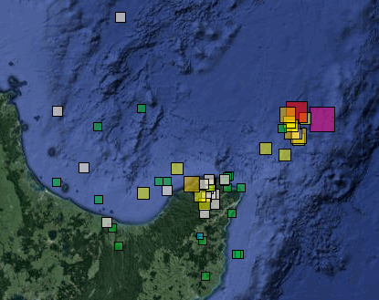
East Cape Ridge Off NI N.Z./Raukumara-East Cape-Awanui Valley/ Matakoa Valley-Lottin Ridge- East Cape Ridge
I grabbed an update off Geonet exactly 24 hours after the 7.1 yesterday.
Was getting too complicated with the foreshocks and the aftershocks on the same file with calculating the elapsed time, so I split the Foreshocks out into seperate file.
But the NZ Topo maps still shows them all, the above applies to the Bing Maps.
Summary at 24 hrs
Foreshocks: mag~1= 0 , mag1= 1 , mag2= 20 , mag3= 11 , mag4= 0
mag5= 1 , mag6= 0 , total= 33
total energy released= 5094.30 TTNT
Aftershocks of the 7.1: mag~1= 0 , mag1= 5 , mag2= 161 , mag3= 116 , mag4= 47
mag5= 5 , mag6= 2 , mag7= 1, total= 336
total energy released= 697,018.972 TTNT
All up 702,113.273 TTNT released so far.
Seems to be deteriorating in an orderly manner now. (see timeline graph]
East Cape Ridge page
Note the title of post, this series is at the junction of 3 GL seismic areas that Puterman and I created a few years ago, this series covers a BIG area, approx 23,240 sq kilometers, and that's not counting the few others on the fringes that likely were triggered off by the big quakes.
East Cape Ridge Off NI N.Z./Raukumara-East Cape-Awanui Valley/ Matakoa Valley-Lottin Ridge- East Cape Ridge
I grabbed an update off Geonet exactly 24 hours after the 7.1 yesterday.
It was getting too complicated with the foreshocks and the aftershocks on the same file with calculating the elapsed time, so I split the Foreshocks out into separate files.
But the NZ Topo maps still shows them all, the above applies just to the Bing Maps.
Summary at 24 hrs
Foreshocks: mag~1= 0 , mag1= 1 , mag2= 20 , mag3= 11 , mag4= 0
mag5= 1 , mag6= 0 , total= 33
total energy released= 5094.30 TTNT
Aftershocks of the 7.1: mag~1= 0 , mag1= 5 , mag2= 161 , mag3= 116 , mag4= 47
mag5= 5 , mag6= 2 , mag7= 1, total= 336
total energy released= 697,018.972 TTNT
All up 702,113.273 TTNT released so far.
Seems to be deteriorating in an orderly manner now. (see timeline graph]
East Cape Ridge page
Note the title of this post, this series is at the junction of 3 GL seismic areas that Puterman and I created a few years ago, this series covers a BIG area, approx 23,240 sq kilometers, and that's not counting the few others on the fringes that likely were triggered off by the big quakes.
edit on 0900000024524516 by muzzy because: (no reason given)
new topics
-
Las Vegas UFO Spotting Teen Traumatized by Demon Creature in Backyard
Aliens and UFOs: 2 hours ago -
2024 Pigeon Forge Rod Run - On the Strip (Video made for you)
Automotive Discussion: 3 hours ago -
Gaza Terrorists Attack US Humanitarian Pier During Construction
Middle East Issues: 3 hours ago -
The functionality of boldening and italics is clunky and no post char limit warning?
ATS Freshman's Forum: 4 hours ago -
Meadows, Giuliani Among 11 Indicted in Arizona in Latest 2020 Election Subversion Case
Mainstream News: 5 hours ago -
Massachusetts Drag Queen Leads Young Kids in Free Palestine Chant
Social Issues and Civil Unrest: 5 hours ago -
Weinstein's conviction overturned
Mainstream News: 7 hours ago -
Supreme Court Oral Arguments 4.25.2024 - Are PRESIDENTS IMMUNE From Later Being Prosecuted.
Above Politics: 8 hours ago -
Krystalnacht on today's most elite Universities?
Social Issues and Civil Unrest: 8 hours ago -
Chris Christie Wishes Death Upon Trump and Ramaswamy
Politicians & People: 9 hours ago
top topics
-
Krystalnacht on today's most elite Universities?
Social Issues and Civil Unrest: 8 hours ago, 9 flags -
Supreme Court Oral Arguments 4.25.2024 - Are PRESIDENTS IMMUNE From Later Being Prosecuted.
Above Politics: 8 hours ago, 8 flags -
Weinstein's conviction overturned
Mainstream News: 7 hours ago, 7 flags -
University of Texas Instantly Shuts Down Anti Israel Protests
Education and Media: 11 hours ago, 6 flags -
Meadows, Giuliani Among 11 Indicted in Arizona in Latest 2020 Election Subversion Case
Mainstream News: 5 hours ago, 5 flags -
Gaza Terrorists Attack US Humanitarian Pier During Construction
Middle East Issues: 3 hours ago, 4 flags -
Massachusetts Drag Queen Leads Young Kids in Free Palestine Chant
Social Issues and Civil Unrest: 5 hours ago, 4 flags -
Las Vegas UFO Spotting Teen Traumatized by Demon Creature in Backyard
Aliens and UFOs: 2 hours ago, 3 flags -
Chris Christie Wishes Death Upon Trump and Ramaswamy
Politicians & People: 9 hours ago, 2 flags -
Any one suspicious of fever promotions events, major investor Goldman Sachs card only.
The Gray Area: 13 hours ago, 2 flags
active topics
-
Las Vegas UFO Spotting Teen Traumatized by Demon Creature in Backyard
Aliens and UFOs • 7 • : rickymouse -
Meadows, Giuliani Among 11 Indicted in Arizona in Latest 2020 Election Subversion Case
Mainstream News • 10 • : chr0naut -
Supreme Court Oral Arguments 4.25.2024 - Are PRESIDENTS IMMUNE From Later Being Prosecuted.
Above Politics • 75 • : Vermilion -
University student disciplined after saying veganism is wrong and gender fluidity is stupid
Education and Media • 50 • : watchitburn -
VP's Secret Service agent brawls with other agents at Andrews
Mainstream News • 55 • : CarlLaFong -
Cats Used as Live Bait to Train Ferocious Pitbulls in Illegal NYC Dogfighting
Social Issues and Civil Unrest • 23 • : Ravenwatcher -
-@TH3WH17ERABB17- -Q- ---TIME TO SHOW THE WORLD--- -Part- --44--
Dissecting Disinformation • 680 • : 777Vader -
Is there a hole at the North Pole?
ATS Skunk Works • 40 • : Oldcarpy2 -
Fossils in Greece Suggest Human Ancestors Evolved in Europe, Not Africa
Origins and Creationism • 89 • : whereislogic -
University of Texas Instantly Shuts Down Anti Israel Protests
Education and Media • 197 • : NorthOS