It looks like you're using an Ad Blocker.
Please white-list or disable AboveTopSecret.com in your ad-blocking tool.
Thank you.
Some features of ATS will be disabled while you continue to use an ad-blocker.

Quake Watch 2016
page: 3share:
we got a small one here in LA
6:40 am pst, about a 3.5 - 4.0
im sure we'll get some aftershocks
6:40 am pst, about a 3.5 - 4.0
im sure we'll get some aftershocks
edit on 6-1-2016 by vjr1113 because: (no reason given)
a reply to: vjr1113
4.8 prelim near Banning.
earthquake.usgs.gov...
*edit- revised to 4.5
4.8 prelim near Banning.
earthquake.usgs.gov...
*edit- revised to 4.5
edit on 6-1-2016 by paradoxious because: (no reason given)
a reply to: vjr1113
Yeah, it is listed as a 4.5 right now.
All that water lubing up the fault lines maybe.
earthquake.usgs.gov...
Yeah, it is listed as a 4.5 right now.
All that water lubing up the fault lines maybe.
earthquake.usgs.gov...
well they're getting a bit bigger than the last one near Devore. last noticeable one was a 3.8 i think. this one felt like someone kicked my
bed
edit on 6-1-2016 by vjr1113 because: (no reason given)
a reply to: paradoxious
Good job we don't get earthquakes here then.
Yet another batch of Irish wet winter weather going overhead. I believe we have had a years worth of rain this month.
We are all very clean and wrinkly.
Good job we don't get earthquakes here then.
Yet another batch of Irish wet winter weather going overhead. I believe we have had a years worth of rain this month.
We are all very clean and wrinkly.
That's funny.
originally posted by: PuterMan
a reply to: paradoxious
Good job we don't get earthquakes here then.
Yet another batch of Irish wet winter weather going overhead. I believe we have had a years worth of rain this month.
We are all very clean and wrinkly.
I think the train of thought here with these areas and quakes, Devore and Banning, is they're at the bottom of rather large mountain regions along the San Andreas Fault, with both areas between the San Andreas and San Jacinto fault zones, although tens-of-miles apart. We've had a rather dry few years, as many know, so, getting hit with a statistically significant amount of rain in a short period might be putting a little extra weight on these areas as well as 'lubricating' things.
I'm slightly hesitant to put much 'weight' into the lubrication thing since the area has a substantial amount of ground water / aquifers: much of the region around Riverside and San Bernardino sources drinking water from the ground rather than piping in from elsewhere, arguable caused by the considerable faulting in the area. Now, perhaps the extended draught conditions we've been in have depleted enough water without causing a moderate quake to permit conditions where the added weight on top could cause sudden quakes?
For now, I'm entertaining the thought the Devore quake group could be considered foreshocks to the Banning one despite the physical separation, particularly considering the relative dearth of fore or after shocks to the one in Banning... two < M1.0 and two > M1.0 preceding and one 1.0 following it within 10 miles over the past 24 hours (from Jan 5, 2016 19:00UTC through Jan 6, 2016). Even going to 7 days, the number doesn't increase dramatically, perhaps 15 quakes within the same radius, most all below M1.5.
edit on 6-1-2016 by paradoxious because: (no reason given)
a reply to: paradoxious
That aloe can cause quakes, and yes so can excess water. If you consider that an inch of rain such as is forecast for us over then next few hours is actually 101 tons of water per acre, it doe not take long to build up substantial weight - good for flooding, landslides and yes earthquakes (but not here as we have been soaked for so long so permanently another few hundred tons makes no difference!).
much of the region around Riverside and San Bernardino sources drinking water from the ground rather than piping in from elsewhere,
That aloe can cause quakes, and yes so can excess water. If you consider that an inch of rain such as is forecast for us over then next few hours is actually 101 tons of water per acre, it doe not take long to build up substantial weight - good for flooding, landslides and yes earthquakes (but not here as we have been soaked for so long so permanently another few hundred tons makes no difference!).
M5.1 Nuclear Explosion - 22km ENE of Sungjibaegam, North Korea
Time
2016-01-06 01:30:01 (UTC)
Nearby Cities
22km (14mi) ENE of Sungjibaegam, North Korea
37km (23mi) WNW of Hau-ri, North Korea
44km (27mi) NNW of Kilju, North Korea
53km (33mi) WSW of Hoemul-li, North Korea
377km (234mi) NE of Pyongyang, North Korea
earthquake.usgs.gov...
This is the first time I have noticed something on the USGS listed as a nuclear explosion, so I thought it was worthy to add to the thread.
www.johnstonsarchive.net...
may be of interest re. nuclear testing
needs an update though, last N. Korea one listed was 2009, I think they have done 2 since, not including this last one?
sure there was one last year too.
may be of interest re. nuclear testing
needs an update though, last N. Korea one listed was 2009, I think they have done 2 since, not including this last one?
sure there was one last year too.
Did a big quake just hit Oklahoma?
Yes. USGS finally has it listed. 15 mins it took them. smh
Edit: Actually it was 2 quakes; a Mag 4.3 followed by a Mag 4.8.
Here is a link to the Clayton, OK seismogram below: Link

This Link to the Mooreland, OK seismo is better: closer to the epicenter.
Yes. USGS finally has it listed. 15 mins it took them. smh
Edit: Actually it was 2 quakes; a Mag 4.3 followed by a Mag 4.8.
edit on 1/6/2016 by Olivine because: (no reason given)
Here is a link to the Clayton, OK seismogram below: Link
edit on 1/6/2016 by Olivine because: add a pic and link
This Link to the Mooreland, OK seismo is better: closer to the epicenter.
edit on 1/6/2016 by Olivine because: (no reason given)
a reply to: Olivine
I just noticed.
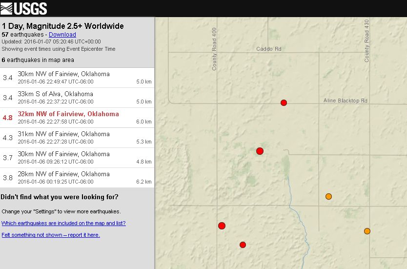
3.4 30km NW of Fairview, Oklahoma 2016-01-06 22:49:47 UTC-06:00 5.0 km
3.4 33km S of Alva, Oklahoma 2016-01-06 22:37:22 UTC-06:00 5.0 km
4.8 32km NW of Fairview, Oklahoma 2016-01-06 22:27:58 UTC-06:00 6.0 km
4.3 31km NW of Fairview, Oklahoma
wow, had to screen shot it...dunno why.
lol
I just noticed.
3.4 30km NW of Fairview, Oklahoma 2016-01-06 22:49:47 UTC-06:00 5.0 km
3.4 33km S of Alva, Oklahoma 2016-01-06 22:37:22 UTC-06:00 5.0 km
4.8 32km NW of Fairview, Oklahoma 2016-01-06 22:27:58 UTC-06:00 6.0 km
4.3 31km NW of Fairview, Oklahoma
wow, had to screen shot it...dunno why.
lol
a reply to: Darkblade71
change that map to satellite view and zoom to 3km/ 1mi, and you will see all the fracking pads there.
With the price of oil at the lowest in a decade, why do they bother messing with the crust
change that map to satellite view and zoom to 3km/ 1mi, and you will see all the fracking pads there.
With the price of oil at the lowest in a decade, why do they bother messing with the crust
a reply to: muzzy
I thought I had read somewhere not that long ago that it is possible they are accidentally activating prehistoric fault lines while doing all of this fracking. Honestly I dunno, but jobs I think would be the main reason to continue fracking while oil prices are so low.
Maybe someone is hoarding that oil to sell later when prices go back up.
Or maybe the gov is buying it and quietly stockpiling enough for ww3...lol
(2 days, 4 hours ago), missed one, almost a M6
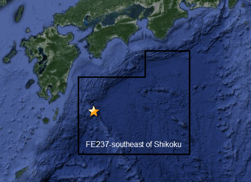
F-E Region: Southeast of Shikoku, Japan
Time: 2016-01-05 02:21:13.4 UTC
Magnitude: 5.9 (Mw)
Epicenter: 132.83°E 30.60°N
Depth: 14 km
Status: M - manually revised
geofon.gfz-potsdam.de...
No Me (energy) reading from IRIS yet, odds are it would be over M6
JMA are calling it 5.6ML, which is unusual that its lower than Mw, for the High Sensitivity Seismograph Network Laboratory have 5.7Mw.
Quite a few aftershocks at the "N PHILIPPINE BASIN" as NIED have called it, 49 so far.
i don't know where the Global Networks got "Southeast of Shikoku, Japan", if you look on the map, if anything, it is SE of Kyushu
and S of Shikoku.
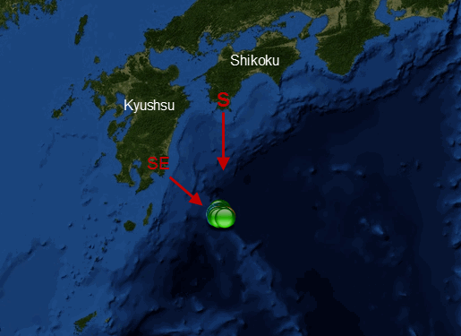
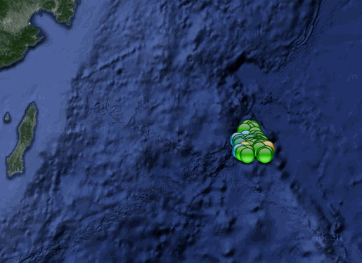
Interactive Bing map (48 events showing)
edit:
OK I will let them off this time FE237-southeast of Shikoku is a funny shape, and the 5.6 quake falls within the borders
F-E Region: Southeast of Shikoku, Japan
Time: 2016-01-05 02:21:13.4 UTC
Magnitude: 5.9 (Mw)
Epicenter: 132.83°E 30.60°N
Depth: 14 km
Status: M - manually revised
geofon.gfz-potsdam.de...
No Me (energy) reading from IRIS yet, odds are it would be over M6
JMA are calling it 5.6ML, which is unusual that its lower than Mw, for the High Sensitivity Seismograph Network Laboratory have 5.7Mw.
Quite a few aftershocks at the "N PHILIPPINE BASIN" as NIED have called it, 49 so far.
i don't know where the Global Networks got "Southeast of Shikoku, Japan", if you look on the map, if anything, it is SE of Kyushu
and S of Shikoku.
Interactive Bing map (48 events showing)
edit:
OK I will let them off this time FE237-southeast of Shikoku is a funny shape, and the 5.6 quake falls within the borders
edit on 010000006616 by muzzy because: (no reason given)
Conspiracy Theory Time.
There is a question that needs asking.
If there is worldwide glut in gas and oil, then why are the earthquakes in Oklahoma rising?
This makes no sense. There are layoffs in the industry. Companies are reducing production because of the glut and the low prices that this has caused. There should be fewer earthquakes. There are no other epidemic of fracking earthquakes anywhere else at the moment. Yes, there are some in Texas, etc. But nothing like Oklahoma. Something is different.
Theory. It is a grand experiment. They are continuing to pump waste water despite the excess in supply, in order to fill up the ground as much as they can with wastewater in order to rupture a fault in order to find out how much pressure it takes to do so. It's a pressure test. Or, they're trying to create a disaster in order to create disaster economics.
Or, no other place wants all the waste water and Oklahoma is importing water from nearby states and they have now become a big toxic land (or I should say "water") land fill.
www.news9.com...
California. Drought, then rain, plus serpentine layers equal a slippy slide.
And I'm back to Oklahoma. I'm always being a wise ass and saying, "The More You Know...", just like the cliche' and slogan. In a mocking way most times. And now is one of those times. The more I know, the less I wish I knew. The idiots in Oklahoma are defying attempts by regulators to stop the pumping.
www.news9.com...
The company is in debt and can't stop pumping. They're going to run the pumps until they go bankrupt, or legislator use legal means, or they create a 6.6 and kill people. I want to use foul language. So, I'll use this a cue to leave my writing fingers alone now.
And for the record, 15 earthquakes in the last 24 hours, 2 being +4s.
Sorry no, 17 earthquakes in 24 hours
There is a question that needs asking.
If there is worldwide glut in gas and oil, then why are the earthquakes in Oklahoma rising?
This makes no sense. There are layoffs in the industry. Companies are reducing production because of the glut and the low prices that this has caused. There should be fewer earthquakes. There are no other epidemic of fracking earthquakes anywhere else at the moment. Yes, there are some in Texas, etc. But nothing like Oklahoma. Something is different.
Theory. It is a grand experiment. They are continuing to pump waste water despite the excess in supply, in order to fill up the ground as much as they can with wastewater in order to rupture a fault in order to find out how much pressure it takes to do so. It's a pressure test. Or, they're trying to create a disaster in order to create disaster economics.
Or, no other place wants all the waste water and Oklahoma is importing water from nearby states and they have now become a big toxic land (or I should say "water") land fill.
www.news9.com...
California. Drought, then rain, plus serpentine layers equal a slippy slide.
And I'm back to Oklahoma. I'm always being a wise ass and saying, "The More You Know...", just like the cliche' and slogan. In a mocking way most times. And now is one of those times. The more I know, the less I wish I knew. The idiots in Oklahoma are defying attempts by regulators to stop the pumping.
www.news9.com...
The company is in debt and can't stop pumping. They're going to run the pumps until they go bankrupt, or legislator use legal means, or they create a 6.6 and kill people. I want to use foul language. So, I'll use this a cue to leave my writing fingers alone now.
And for the record, 15 earthquakes in the last 24 hours, 2 being +4s.
edit on 7-1-2016 by ericblair4891 because: (no reason given)
Sorry no, 17 earthquakes in 24 hours
edit on 7-1-2016 by ericblair4891 because: (no reason given)
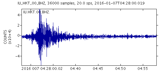
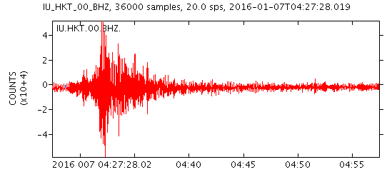
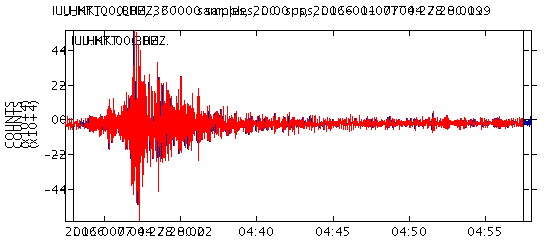
Fairview, OK
Latest magnitudes from USGS are;
Scientific Moment Tensor
First quake 04:27:28 (UTC) up from 4.3 to 4.74Mwr (Regional Moment Tensor )page here or 4.8mb± 0.1 scientific_origin page
Second quake, 30 seconds later 04:27:58 (UTC), 4.8Mwr page here or 4.4mb scientific_originvpage
No Mww for the first one, but the 2nd one is showing 4.7Mww
note on the scientific_origin pages how much the depth varies 4.8 - 7km !!, and officially (on the MT pages the depths are 7.0km and 8.0Km) so that means first quake possibly happened at ground level given the uncertainty ± !!!??
IRIS are showing MB
both at 4.8MB
First quake page
Second quake page
near impossible to split the traces
here I superimposed the 2nd quake (red) trace over the first (blue) trace from Hockley, Texas (IRIS) with the timemarks set on top of each other
edit: AAaaargggh
After I posted all that here I clicked on the link for the first quake MT, now it's showing 4.42 ??!! WTF?
and 9km deep
I don't think they have a clue!
edit on 010000006616 by muzzy because: (no reason given)
new topics
-
Has Tesla manipulated data logs to cover up auto pilot crash?
Automotive Discussion: 57 minutes ago -
whistleblower Captain Bill Uhouse on the Kingman UFO recovery
Aliens and UFOs: 5 hours ago -
1980s Arcade
General Chit Chat: 8 hours ago -
Deadpool and Wolverine
Movies: 8 hours ago -
Teenager makes chess history becoming the youngest challenger for the world championship crown
Other Current Events: 9 hours ago -
CIA botched its handling of sexual assault allegations, House intel report says
Breaking Alternative News: 10 hours ago
top topics
-
Lawsuit Seeks to ‘Ban the Jab’ in Florida
Diseases and Pandemics: 13 hours ago, 20 flags -
Starburst galaxy M82 - Webb Vs Hubble
Space Exploration: 15 hours ago, 13 flags -
The Superstition of Full Moons Filling Hospitals Turns Out To Be True!
Medical Issues & Conspiracies: 17 hours ago, 8 flags -
CIA botched its handling of sexual assault allegations, House intel report says
Breaking Alternative News: 10 hours ago, 8 flags -
15 Unhealthiest Sodas On The Market
Health & Wellness: 15 hours ago, 6 flags -
whistleblower Captain Bill Uhouse on the Kingman UFO recovery
Aliens and UFOs: 5 hours ago, 6 flags -
1980s Arcade
General Chit Chat: 8 hours ago, 4 flags -
Deadpool and Wolverine
Movies: 8 hours ago, 3 flags -
Teenager makes chess history becoming the youngest challenger for the world championship crown
Other Current Events: 9 hours ago, 3 flags -
Has Tesla manipulated data logs to cover up auto pilot crash?
Automotive Discussion: 57 minutes ago, 0 flags
active topics
-
Lawsuit Seeks to ‘Ban the Jab’ in Florida
Diseases and Pandemics • 23 • : burritocat -
Has Tesla manipulated data logs to cover up auto pilot crash?
Automotive Discussion • 1 • : andy06shake -
15 Unhealthiest Sodas On The Market
Health & Wellness • 36 • : tanstaafl -
My wife just had a very powerful prophetic dream - massive war in Israel...
The Gray Area • 12 • : SchrodingersRat -
-@TH3WH17ERABB17- -Q- ---TIME TO SHOW THE WORLD--- -Part- --44--
Dissecting Disinformation • 606 • : burritocat -
"We're All Hamas" Heard at Columbia University Protests
Social Issues and Civil Unrest • 199 • : FlyersFan -
It takes One to Be; Two to Tango; Three to Create.
Philosophy and Metaphysics • 7 • : Terpene -
Take it to the Media when you protest.. Don't let them ignore you!
Education and Media • 4 • : SchrodingersRat -
They Killed Dr. Who for Good
Rant • 62 • : FlyersFan -
Definitive 9.11 Pentagon EVIDENCE.
9/11 Conspiracies • 421 • : Lazy88