It looks like you're using an Ad Blocker.
Please white-list or disable AboveTopSecret.com in your ad-blocking tool.
Thank you.
Some features of ATS will be disabled while you continue to use an ad-blocker.

Quake Watch 2016
page: 18share:
a reply to: intergalactic fire
I did a couple of posts on the Alboran Sur swarm here on ATS already;
posted on Mar, 11 2016 @ 01:38 PM
posted on Mar, 13 2016 @ 08:16 AM
posted on Mar, 16 2016 @ 05:54 AM
data from www.02.ign.es...
I see it still going strong, I'll do an update later today.
The Alboran Islet is between 70-80km NE of the current swarm of earthquakes. Looks like it hasn't been volcanic for eons, just a flat platform now.
Could be though, the swarm and the islet are both on the same (Alboran) Ridge
a reply to: intergalactic fire
Good to see someone else is interested in what is going on there.
I grabbed that data from Spain and updated the timeline graph.
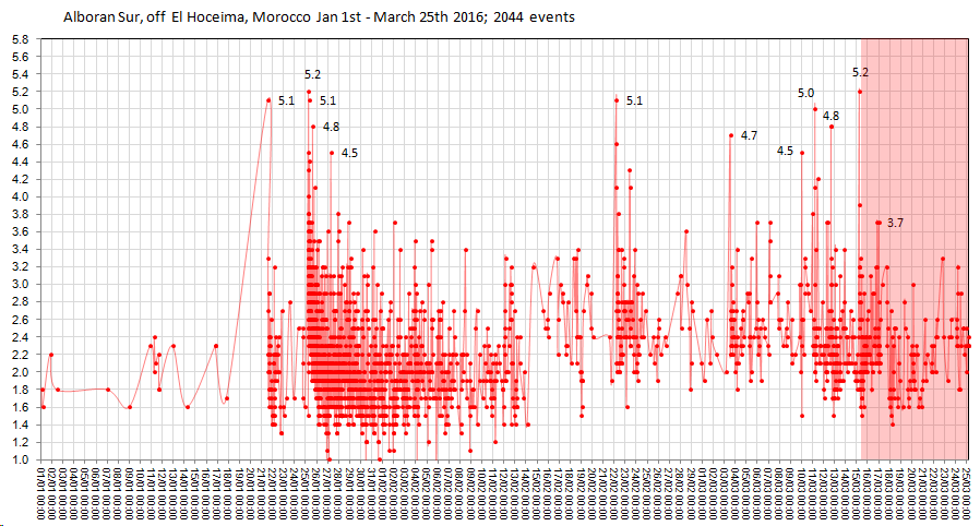
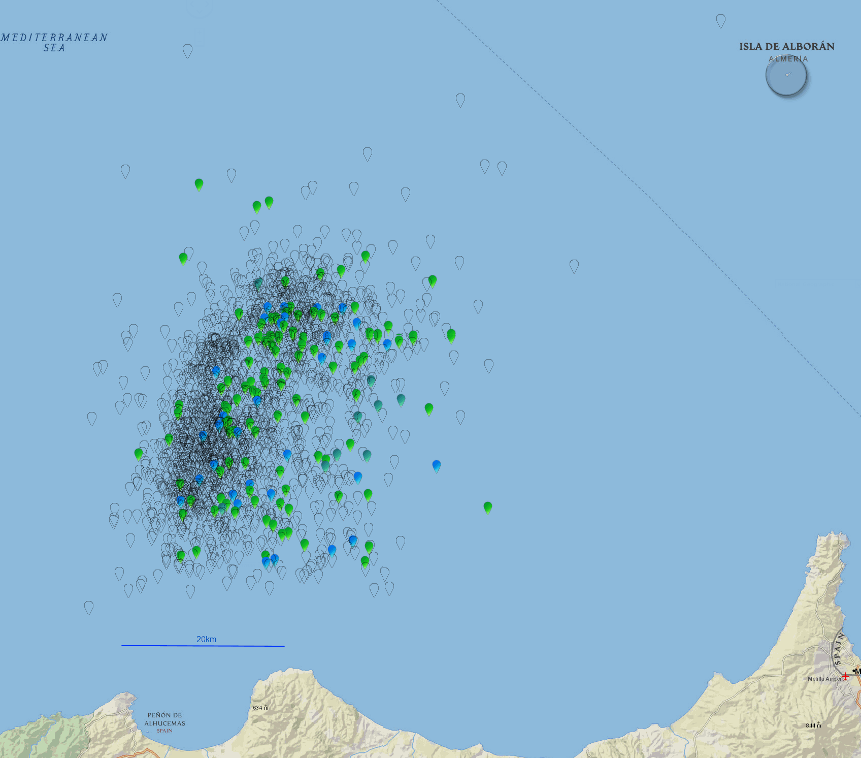
also looking at the latest 10 days worth in comparison to what had preceded before (since Jan 1 2016) on the graph (highlighted in pink) the magnitudes are down a bit, on the map they are pretty much spread through the whole area as before. I did a couple of maps, the black outlined icons are pre 15/03/2016 16:29, the coloured ones are by magnitude since that date.
overview of the whole swarm
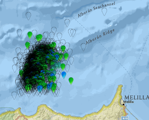
the one below is a closer view, the image is huge, 1696 pixels wide
rightclickviewimage, then click on + magnifying glass to get the full size.
Good to see someone else is interested in what is going on there.
I grabbed that data from Spain and updated the timeline graph.
also looking at the latest 10 days worth in comparison to what had preceded before (since Jan 1 2016) on the graph (highlighted in pink) the magnitudes are down a bit, on the map they are pretty much spread through the whole area as before. I did a couple of maps, the black outlined icons are pre 15/03/2016 16:29, the coloured ones are by magnitude since that date.
overview of the whole swarm
the one below is a closer view, the image is huge, 1696 pixels wide
rightclickviewimage, then click on + magnifying glass to get the full size.
originally posted by: muzzy
a reply to: ericblair4891
Looks like the increased numbers may be due to better technology, picking up more and more quakes, probably those offshore one's,
Also noting not many big quakes in the last 4 years.
SSN Data goes back to 2006, I'll have a look at the rest tomorrow.
Yeah looks like the case
2012 = 356 events
oopps that was just for 26 days in March, my mistake, will do it again
2009 = 441 events
2010 = 531 events
2011 = 865 events
2012 1066 events
so looks like SSN is a developing network
could just be the period (85 days at the start of the year)
edit on 03000000848416 by muzzy because: (no reason given)
edit on 03000000848416 by muzzy because: (no reason given)
There was a large carbon Monoxide release in Oklahoma.
earth.nullschool.net.../chem/surface/level/overlay=cosc/orthographic=-103.48,43.34,579
I wanted to post this in Quake watch, in the event Oklahoma has a large earthquake.
earth.nullschool.net.../chem/surface/level/overlay=cosc/orthographic=-103.48,43.34,579
I wanted to post this in Quake watch, in the event Oklahoma has a large earthquake.
a reply to: ericblair4891
Re Hawthorne. Interesting article, straight away we have Mud Springs Volcano in the image.
Elsewhere, in Nevada, Bald Mountain Sheldon Refuge Area seems to have quietened down.
Re Hawthorne. Interesting article, straight away we have Mud Springs Volcano in the image.
Elsewhere, in Nevada, Bald Mountain Sheldon Refuge Area seems to have quietened down.
slow day. USGS has been averaging 28-30 a day, today only 21.
hopefully they'll be winding down.
hopefully they'll be winding down.
originally posted by: muzzy
a reply to: ericblair4891
Elsewhere, in Nevada, Bald Mountain Sheldon Refuge Area seems to have quietened down.
I thought I had updated this in 2016, but the only reference I can find in the ATS search is discussion about Bald Mt versus Challis, Idaho here. That must be when I updated the timeline graph for Bald Mt Sunday, 24 January 2016. But I didn't post anything specific on Bald Mt.
All other references are in QW2015.
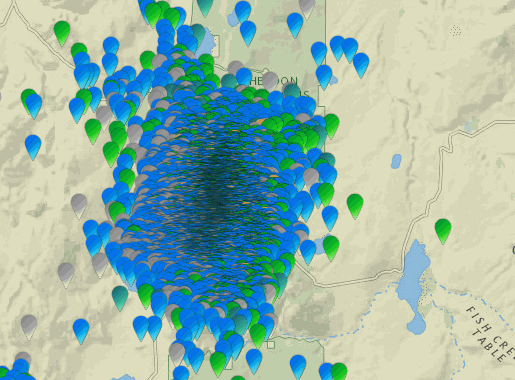
Geez doesn't time fly by, I hadn't updated the data for 62 days!
so here is the latest (yesterday), since Jan 23; new events are in black.
only 128 new quakes, biggest two x 3.5's. Data is from both NSL and ANSS.
rightclickviewimageforfullsize
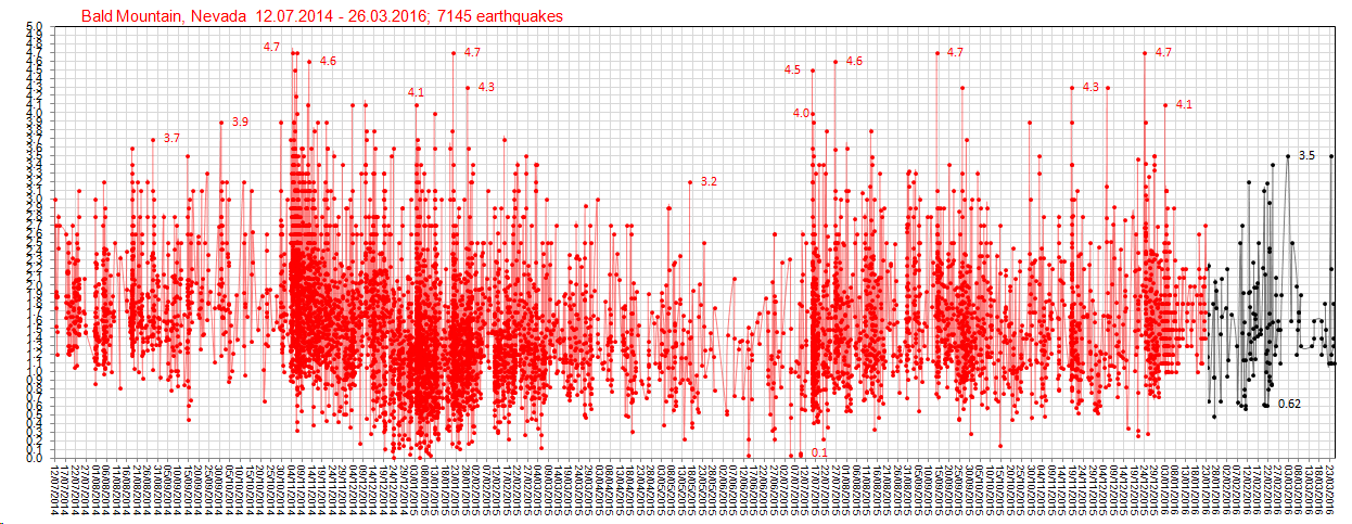
full swarm maps aren't much use now, the whole mountain has been saturated,
but just for comparison
latest events in the last 62 days
compared to the whole swarm since July 2014
edit on 03000000858516 by muzzy because: (no reason given)
a reply to: muzzy
What happens when I do these is I see something else and start looking at that,
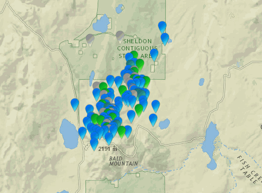
now with eric mentioning Hawthorne I have run the data for Nevada and then viewing on the USGS Topo Map and find that Just looking at the last 62 days; there are bunches of swarms all over the area.
The main swarm that shows on NSL is at the Western end of the Garfield Hills, also at the NE corner of the Hawthorne Ammunition Depot !!! On satellite/aerial view there are bunkers are all across the Walker Lake Valley, in fact the USGS Topo map shows the entire valley as the "Hawthorne Naval Ammunition Depot"
Another swarm between Mable Mt and the W end of the Garfield Hills, north of McGill Canyon. Just west of the swarm are a whole bunch of Mines, with names like La Panta, Golden Eagle, Golden Bomber, Good Hope No2, Gold Bug, Evening Star, Central, Good Hope, Pamlico, Sunset. They look like they are abandoned mines, no activity on aerial view. Who knows how long the tunnels go, keeping in mind that Australia also has a lot of earthquakes that can be traced to collapsed abondoned mines.
Another swarm at the end of Cottonwood Creek north west of Walker Lake town/resort.
Some activity south of Hawthorne, down Whiskey Flat near Table Mt, south of Powell canyon.
Also in the Candelaria Hills ESE of above
Also NW and SE of Schurz on the Walker Lake Indian Reservation.
a few at Mud Spring Valley (volcano), scene of the 2011 swarm.
Interesting stuff.
Demands further investigation .............
What happens when I do these is I see something else and start looking at that,
now with eric mentioning Hawthorne I have run the data for Nevada and then viewing on the USGS Topo Map and find that Just looking at the last 62 days; there are bunches of swarms all over the area.
The main swarm that shows on NSL is at the Western end of the Garfield Hills, also at the NE corner of the Hawthorne Ammunition Depot !!! On satellite/aerial view there are bunkers are all across the Walker Lake Valley, in fact the USGS Topo map shows the entire valley as the "Hawthorne Naval Ammunition Depot"
Another swarm between Mable Mt and the W end of the Garfield Hills, north of McGill Canyon. Just west of the swarm are a whole bunch of Mines, with names like La Panta, Golden Eagle, Golden Bomber, Good Hope No2, Gold Bug, Evening Star, Central, Good Hope, Pamlico, Sunset. They look like they are abandoned mines, no activity on aerial view. Who knows how long the tunnels go, keeping in mind that Australia also has a lot of earthquakes that can be traced to collapsed abondoned mines.
Another swarm at the end of Cottonwood Creek north west of Walker Lake town/resort.
Some activity south of Hawthorne, down Whiskey Flat near Table Mt, south of Powell canyon.
Also in the Candelaria Hills ESE of above
Also NW and SE of Schurz on the Walker Lake Indian Reservation.
a few at Mud Spring Valley (volcano), scene of the 2011 swarm.
Interesting stuff.
Demands further investigation .............
edit on 03000000858516 by muzzy because: (no reason given)
further to: muzzy
NSL article that eric posted.
and the link at the bottom of the page
yes indeed, 4011 of them all together, to the end of 2011. data from ANSS.
rightclickviewimageforfullsize
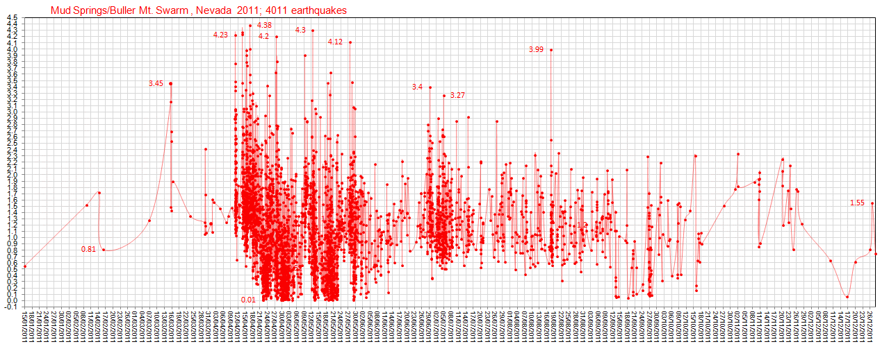
image below is the same area as NSL had in the 1st article, my updated version
rightclickviewimageforfullsize
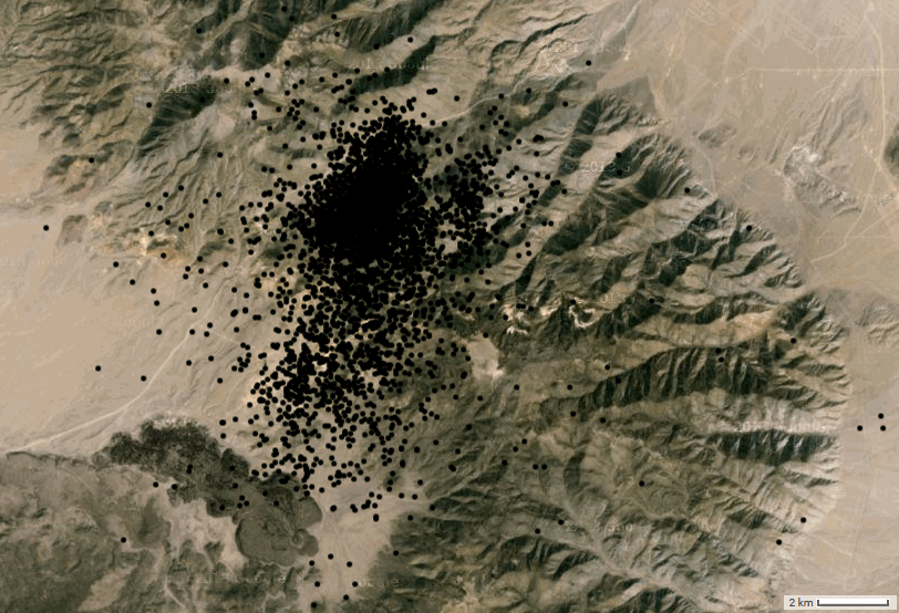
everyone incl. True American thread here on ATS thought they were volcanic, but they weren't, and nothing happened, except the swarm.
NSL article that eric posted.
and the link at the bottom of the page
In all, there have been several hundred events of Magnitude 1 and larger; only a small fraction of the entire sequence has been reviewed There have been 1000's of smaller magnitude events.
yes indeed, 4011 of them all together, to the end of 2011. data from ANSS.
rightclickviewimageforfullsize
image below is the same area as NSL had in the 1st article, my updated version
rightclickviewimageforfullsize
everyone incl. True American thread here on ATS thought they were volcanic, but they weren't, and nothing happened, except the swarm.
edit on 03000000858516 by muzzy because: (no reason given)
a reply to: ericblair4891
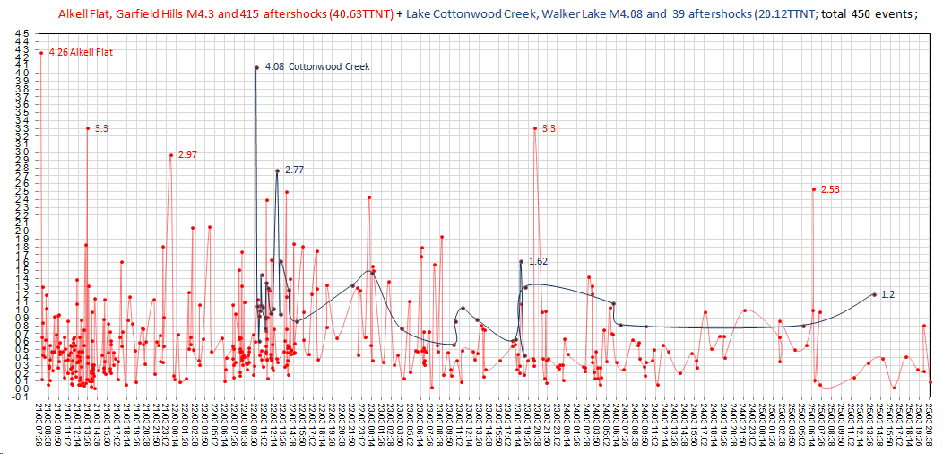
In the two series since 21/03/2015, 415 of them at Alkell Falt, Garfield Hills and 36 at Cottonwood Creek, Walker Lake.
I wouldn't call these swarms, they are two seperate M4 events with aftershocks. The 2nd quake may have been triggered by the earlier one, hard to say as they are 41.28 km apart. That was enough distance in the NZ Canterbury Series of 2011 to define the 6's as seperate events, but really they were all aftershocks of the 2010 7.1
Maybe these Hawthorne ones are all just aftershocks of the 1932 M7.2 at Gabbs Valley, 43.81 km away !!???
the graph below shows these two series coloured by Red=Garfield Hills Blue= Walker Lake
rightclickviewimageforfullsize
Oh and to go back to Hawthorne, the epicenters are in a different place. And there's two areas affected at the moment if you add in those earthquakes by the lake.
In the two series since 21/03/2015, 415 of them at Alkell Falt, Garfield Hills and 36 at Cottonwood Creek, Walker Lake.
I wouldn't call these swarms, they are two seperate M4 events with aftershocks. The 2nd quake may have been triggered by the earlier one, hard to say as they are 41.28 km apart. That was enough distance in the NZ Canterbury Series of 2011 to define the 6's as seperate events, but really they were all aftershocks of the 2010 7.1
Maybe these Hawthorne ones are all just aftershocks of the 1932 M7.2 at Gabbs Valley, 43.81 km away !!???
the graph below shows these two series coloured by Red=Garfield Hills Blue= Walker Lake
rightclickviewimageforfullsize
edit on 03000000868616 by muzzy because: I chose Red and Blue in respect of these being USA quakes, but these are also th colours of the NZ
flag which has the 4 stars of the Southern Cross, Red and Blue and White, oh and its the same colours as Britain and France too
Watched San Andreas movie on TV last night.
I don't watch too many movies on TV due to the advertising, but being Easter Sunday there were no adverts so I watched it from about half way.
What a load of hooeey, the special effects were pretty good but come on, a Tsunami from San Andreas, and M9.4 ???
It has probably been discussed on ATS already about this, but it's not possible, the Fault is too short.
I don't think it is even capable of a M8.
edit on 03000000868616 by muzzy because: (no reason given)
4.9, 2016/3/27 13:55:44, 30.75, -113.75, 33.0, GULF OF CALIFORNIA
4.7, 2016/3/27 12:2:40, 30.25, -114.75, 33.0, GULF OF CALIFORNIA
4.8, 2016/3/27 8:31:20, 30.50, -114.50, 33.0, GULF OF CALIFORNIA
www.ldeo.columbia.edu...
USlessGS are only showing a 4.4 @ 14:33:42 earthquake.usgs.gov...
SLBS (Sierra la Laguna Baja California Sur, Mexico)
rightclickviewimageforfullsize
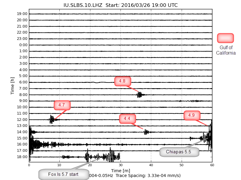
SSN Mexico also confirm these, although lower magnitudes
www2.ssn.unam.mx:8080...
4.7, 2016/3/27 12:2:40, 30.25, -114.75, 33.0, GULF OF CALIFORNIA
4.8, 2016/3/27 8:31:20, 30.50, -114.50, 33.0, GULF OF CALIFORNIA
www.ldeo.columbia.edu...
USlessGS are only showing a 4.4 @ 14:33:42 earthquake.usgs.gov...
edit on 03000000868616
by muzzy because: (no reason given)
SLBS (Sierra la Laguna Baja California Sur, Mexico)
rightclickviewimageforfullsize
edit on 03000000868616 by muzzy because: (no reason given)
SSN Mexico also confirm these, although lower magnitudes
www2.ssn.unam.mx:8080...
edit on 03000000868616 by muzzy because: (no reason given)
a reply to: muzzy
wow, and a bunch more in the last 4 hours
4.5, 2016-03-28, 01:04:03, 29.91,-114.39, 33.0,131 km al SURESTE de SAN FELIPE, BC
5.44, 2016-03-28 00:12:59,30.0,-114.5,15.0,119 km al SURESTE de SAN FELIPE, BC
4.3, 2016-03-27 20:21:35,30.01-113.86,31.0,147 km al SURESTE de SAN FELIPE, BC
www2.ssn.unam.mx:8080...
LISS graph for Sierra la Laguna Baja California Sur, Mexico
will roll over in 24hrs, but I saved it
LDEO has another one too, on the peninsula itself
5.3, 2016/3/28 0:3:36, 29.75, -114.25, 33.0, 5.3, BAJA CALIFORNIA, MEXICO
www.ldeo.columbia.edu...
edit: oh thats the one on SSN I missed because the location wasn't SURESTE de SAN FELIPE, BC, but SSN have it right out in the middle of the Gulf.
holy cow is the San Andreas about to RIP?
You would thing USGS would be all over this, being the trigger point for Salton Sea area and further north, keep a closer eye on it maybe, geez they are only showing 3 quakes out of the 6, just because they don't show ex USA quakes over 4.5,
how dumb is that?
what if there were 100 quakes at 4.3? would they show them?
doh
No wonder Mexicans are taking over the USA, Americans so lazy.
edit on 03000000868616 by muzzy because: (no reason given)
the SSN lines of data won't copy and paste in item lines, so I won't post the list
but the smaller quakes are showing also now
these icons on the map are just from 27th and 28th March
looks like it started with a M3.9 on 27th 05:34:50 (currently number 93 on the map)
but the smaller quakes are showing also now
these icons on the map are just from 27th and 28th March
looks like it started with a M3.9 on 27th 05:34:50 (currently number 93 on the map)
a reply to: muzzy
Thank you for looking at Mexico and Nevada. I noticed the Baja earthquakes right away and began wondering. As you stated, Salton Sea has long been a place to watch. I know you've stated that Mexico's increase could be reporting due to more monitoring, but I don't know if I agree. Mexico has lots of problems, but taking earthquakes seriously isn't one of them. They have modern buildings that focus on Mexico's long history with earthquakes. The only way to know for sure is to ask Mexico and I'm lazy. Yesterday, just before the Baja earthquakes, I was actually wondering why Mexico had stopped moving. After a bit of a spike, it went real quiet, and then the North end went off. Since then, the south end went back to it's usual busy self.
Nevada. Well, let's just keeping watching. Now there's a bit of new activity just to the south of Hawthorne. Not much of a swarm. 15 tiny earthquakes. Many of the Hawthorne earthquakes are tiny and in negative magnitudes. Some of them had question marks for magnitudes, which makes me laugh.
Northern Nevada is still active, but you are right that it is ebbing.
I went and looked at the Mexican report and man does that map look busy. If the year after year increase in Mexico isn't technical, then what does that mean? Hmmmm.
My spidey sense are tweeking all over Mexico. Logically, I could be considering Alaska seeing that it's begun to perk up a bit.
Muzzy, you can ignore this. The moon, I think upcoming alignments mean big things...
edit on 28-3-2016 by ericblair4891 because: (no reason given)
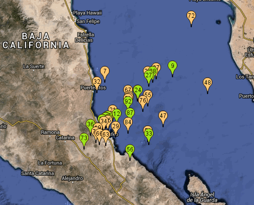
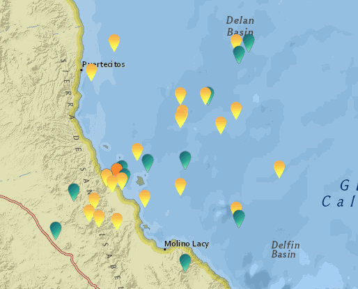
Here is the Baja data in a familiar format;
Coloured by magnitude
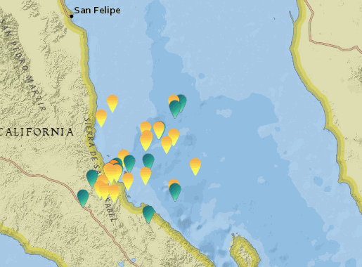
closer view of that
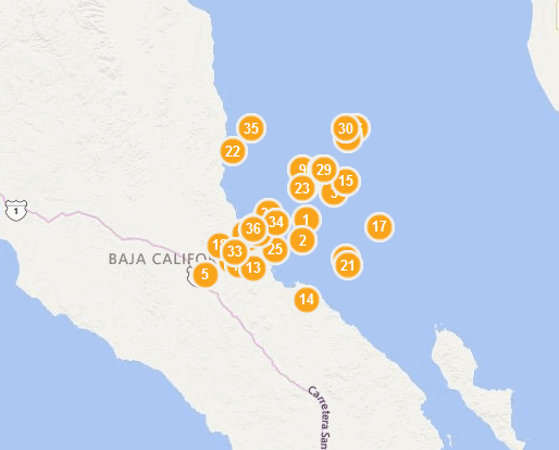
Interactive Bing Version numbered by time
Timeline Graph
rightclickviewimageforfullsize
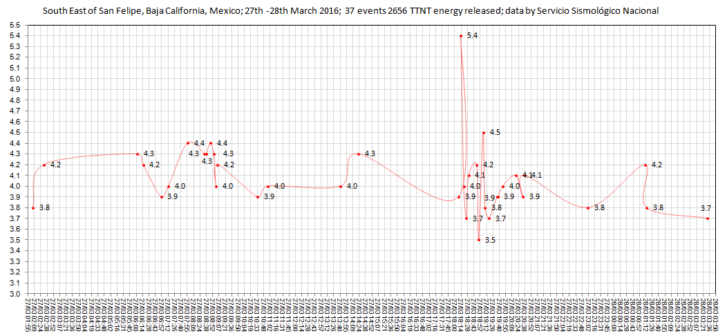
the M5.4 was approx 10km from isla San Luis volcano
Coloured by magnitude
closer view of that
Interactive Bing Version numbered by time
Timeline Graph
rightclickviewimageforfullsize
the M5.4 was approx 10km from isla San Luis volcano
edit on 03000000888816 by muzzy
because: had the maps in the wrong order
USGS records a 4.6 vicinity of Ferndale CA
bout 120 miles south of Oregon
Cascadia country?
Time 2016-03-30 19:47:44 UTC
Location 40.990°N 127.183°W
Depth 10.0 km
clarification; USGS says 250 klicks WNW of Ferndale, which puts it in the Pacific.
hopefully, only this, and nothing more.
bout 120 miles south of Oregon
Cascadia country?
Time 2016-03-30 19:47:44 UTC
Location 40.990°N 127.183°W
Depth 10.0 km
clarification; USGS says 250 klicks WNW of Ferndale, which puts it in the Pacific.
hopefully, only this, and nothing more.
edit on 30-3-2016 by ElGoobero because: clarification
M6.0 - 56km SE of Shingu, Japan
33.373 °N 136.413 °E depth=10.0 km (6.2 mi)
Time
2016-04-01 02:39:07 (UTC)
2016-03-31 21:39:07 (UTC-05:00) in your timezone
Times in other timezones
Nearby Cities
56km (35mi) SE of Shingu, Japan
79km (49mi) SSE of Owase, Japan
105km (65mi) ESE of Tanabe, Japan
125km (78mi) SSW of Ise, Japan
395km (245mi) SW of Tokyo, Japan
USGS
EMSC 6.2Mw
edit on 31-3-2016 by lurksoften because: (no reason
given)
new topics
-
When an Angel gets his or her wings
Religion, Faith, And Theology: 50 minutes ago -
Comparing the theology of Paul and Hebrews
Religion, Faith, And Theology: 1 hours ago -
Pentagon acknowledges secret UFO project, the Kona Blue program | Vargas Reports
Aliens and UFOs: 2 hours ago -
Boston Dynamics say Farewell to Atlas
Science & Technology: 2 hours ago -
I hate dreaming
Rant: 3 hours ago -
Man sets himself on fire outside Donald Trump trial
Mainstream News: 5 hours ago -
Biden says little kids flip him the bird all the time.
Politicians & People: 5 hours ago -
The Democrats Take Control the House - Look what happened while you were sleeping
US Political Madness: 6 hours ago -
Sheetz facing racial discrimination lawsuit for considering criminal history in hiring
Social Issues and Civil Unrest: 6 hours ago -
In an Historic First, In N Out Burger Permanently Closes a Location
Mainstream News: 8 hours ago
top topics
-
The Democrats Take Control the House - Look what happened while you were sleeping
US Political Madness: 6 hours ago, 16 flags -
In an Historic First, In N Out Burger Permanently Closes a Location
Mainstream News: 8 hours ago, 14 flags -
A man of the people
Medical Issues & Conspiracies: 13 hours ago, 8 flags -
Biden says little kids flip him the bird all the time.
Politicians & People: 5 hours ago, 8 flags -
Man sets himself on fire outside Donald Trump trial
Mainstream News: 5 hours ago, 7 flags -
Pentagon acknowledges secret UFO project, the Kona Blue program | Vargas Reports
Aliens and UFOs: 2 hours ago, 5 flags -
4 plans of US elites to defeat Russia
New World Order: 15 hours ago, 4 flags -
Sheetz facing racial discrimination lawsuit for considering criminal history in hiring
Social Issues and Civil Unrest: 6 hours ago, 3 flags -
Are you ready for the return of Jesus Christ? Have you been cleansed by His blood?
Religion, Faith, And Theology: 10 hours ago, 3 flags -
Boston Dynamics say Farewell to Atlas
Science & Technology: 2 hours ago, 3 flags
active topics
-
The Democrats Take Control the House - Look what happened while you were sleeping
US Political Madness • 61 • : Threadbarer -
I hate dreaming
Rant • 5 • : ScarletDarkness -
Man sets himself on fire outside Donald Trump trial
Mainstream News • 32 • : cherokeetroy -
Pentagon acknowledges secret UFO project, the Kona Blue program | Vargas Reports
Aliens and UFOs • 5 • : Ophiuchus1 -
-@TH3WH17ERABB17- -Q- ---TIME TO SHOW THE WORLD--- -Part- --44--
Dissecting Disinformation • 546 • : MetalThunder -
Boston Dynamics say Farewell to Atlas
Science & Technology • 4 • : Terpene -
12 jurors selected in Trump criminal trial
US Political Madness • 111 • : WeMustCare -
Election Year 2024 - Interesting Election-Related Tidbits as They Happen.
2024 Elections • 68 • : WeMustCare -
Candidate TRUMP Now Has Crazy Judge JUAN MERCHAN After Him - The Stormy Daniels Hush-Money Case.
Political Conspiracies • 401 • : WeMustCare -
So I saw about 30 UFOs in formation last night.
Aliens and UFOs • 36 • : Arbitrageur