It looks like you're using an Ad Blocker.
Please white-list or disable AboveTopSecret.com in your ad-blocking tool.
Thank you.
Some features of ATS will be disabled while you continue to use an ad-blocker.

Quake Watch 2016
page: 14share:
Surprised I didn't feel this one, I was in Seatoun which is at the entrance to Wellington harbour. Maybe I was driving at the time, had just left the
work site.
1183 felt reports
Public ID 2016p140897
Intensity severe
Universal Time February 22 2016, 3:09:56
NZ Daylight Time Mon, Feb 22 2016, 4:09:56 pm
Depth 8 km
Magnitude 5.0 (4.9683)
Location 30 km south-east of Seddon
Latitude, Longitude -41.89, 174.25
Agency WEL(GNS_Primary)
www.geonet.org.nz...
Actually I was already out of the city and near the West Coast by then.
Lucky!, an hour before I was driving through two tunnels, I always get nervous about driving through those when a earthquake hits, no where to go!
edit on 02000000515116 by muzzy because: (no reason given)
edit on 02000000515116 by muzzy because: (no reason given)
Why hasn't someone else post the California earthquake? 4.8m.
Heck, I wouldn't have caught it expect for it showed up on Yellowstone's webicorders on the south end- so I was just locating. I'm not saying nothing, but, when you add in the other Ludlow ones around 4 ish, it makes you not say nothing.
earthquake.usgs.gov...
Heck, I think the trace showed up really good in Nicaragua.
edit on 23-2-2016 by ericblair4891 because: (no reason given)
a reply to: ericblair4891
Felt it at home. Felt the Big Pine one last week, clear on the other side of the mountains. Surprised by two in a week. Cat was scared.
Local news says this one is probably not caused by fracking, however, they are mistaken on the depth. This Wasco one IS in the depth of a fracking quake, and in a fracking area.
a reply to: Bishop2199
Thought this one was worth following the aftershock sequence on, so did a page on it, with maps and graph.
e off fukushima pref 5.3 aftershocks
113 aftershocks in 3 days, about average for a Japan low M5.
It must be the saturation of recording instruments that NIED /JMA have there, we don't normally see so many aftershocks elsewhere in the World for such moderate quakes (except California maybe)
a reply to: desert
Ok, I stand corrected re depth of Wasco; it was deeper than I originally read, but still deeper than the local news, too. So I will rule out fracking as a direct cause.
What IS interesting is that it is not associated with a known fault, although it is close (east of) to San Andreas fault. Water table decline due to prolonged drought?... seems too deep, too. So a puzzle. maybe one for geologists.
This page has some interesting info. Seems like quakes in Wasco are increasing. And a short, good read here, to see what area looks like and a geologist's take on the quake.
Shake and bake out here is normal, but I really feel for those in Oklahoma and elsewhere who get the fracking quakes with a magnitude similar to this one.
ETA from the second source
The Great Valley indeed has few active faults, but the Bakersfield region is a definite exception. The south end of the valley is a structural nexus in California where five geologic provinces come together. The region is riddled with structures related to movement along faults like the San Andreas, the Garlock, and the White Wolf, which generated a magnitude 7.6 magnitude earthquake in 1952 that killed a dozen people. A few faults are mapped close to Wasco, including the Pond-Poso Creek fault
edit on 24-2-2016 by desert because: ETA
a reply to: desert
If you are looking at the same area I am.
It is a fracking site
I just want to add, I do not mean to be snarkey.
Maybe we are talking about different area's.
ATS is being goofy, so I am not sure there wasn't a post between ours.
Guys, this is really getting crazy..... Lets fix this!!!!!
If you are looking at the same area I am.
It is a fracking site
I just want to add, I do not mean to be snarkey.
Maybe we are talking about different area's.
ATS is being goofy, so I am not sure there wasn't a post between ours.
Guys, this is really getting crazy..... Lets fix this!!!!!
edit on 24-2-2016 by crappiekat because: (no reason given)
a reply to: crappiekat
I believe we are looking at the same area. For sure there is mucho oil drilling going on in the south San Joaquin Valley (aka Central Valley). Big increase the last few years.
But fracking/waste injection quakes don't happen that far down (22 kilometers), usually three to five kilometers. Wasco is at the bottom of the Valley; the San Andreas Fault passes through west of it, and to the southeast are some local active faults, however, this quake is not associated with any known fault. Might make for a research project. Maybe it's a combination of fracking, land subsidence due to water table decrease, and an unknown fault, or .....?
M4.0 - 31km E of Jackson, Wyoming
43.509 °N 110.394 °W depth=5.0 km (3.1 mi)
Time
2016-02-26 23:00:39 (UTC)
2016-02-26 17:00:39 (UTC-06:00) in your timezone
Times in other timezones
Nearby Cities
29km (18mi) E of Jackson, Wyoming
117km (73mi) ESE of Rexburg, Idaho
127km (79mi) E of Ammon, Idaho
132km (82mi) E of Idaho Falls, Idaho
329km (204mi) NNE of Salt Lake City, Utah
USGS
edit on 26-2-2016 by lurksoften because: (no reason
given)
I'm not gonna say nothing about no mid-Atlantic earthquakes due to no weather or wind or whatnot.
I kept trying to tell myself not to write even though I keep thinking about clusters. To me, today, Puerto Rico seemed really active. But this seems like a stupid thought because Puerto Rico is one of the most earthquakey places in the whole world. It's constant. So, if I check today compared to the rest of the week, yes, today is above average. So, lots of earthquakes.
I still didn't want to write. But then I remember Idaho. And yup, that one is return to mild swarm state as well. Woah there Nelly, Nevada is still riding along with Idaho at a steady swarm clip. Hmmm. Let's forget the fact there was an earthquake in Wyoming. I'm sure it's not related. At first, I assured myself that since there's mountains and glaciers in that neighbourhood, then it had to be tectonic. I'm sure it was....
I have to add, because I'm a dolt and had to look again. In the mid-Atlantic, there's a line of storms and the wind is focus near the epicenter. The epicenter is in the same basic area. Pressure and that set down force I was talking about are stressing the rift. The wave on the seafloor are rubbed by the rippling and the tears the rift open like a wound would when it's over used in exercise.
edit on 26-2-2016 by ericblair4891 because:
(no reason given)
originally posted by: muzzy
I really need to get the Canterbury series converted to NZ Topo maps (Googles maps are now blank) as it is a good reference series for questions about aftershocks.
Well I finally did it!
It took me 3 hours to convert the page to NZ Topo Maps.
Also included now are several Bing maps (links) for the M5+ events in the series.
Bing maps is good to show sequential series by number, even if the icons are a bit old fashioned.
One thing I haven't done yet is to do Timeline graphs for each part of the series, I've had to reverse process the KMZ file to get it back to Excel CSV to do this.
Should have a go at that later today.
NZ M5+, 2011
Note new Pies on the home page too.
If any of you are interested in an easy to understand look at what we know about the Cascadia Subduction zone, this
youtube video from Central Washington University, is a great intro.
The lecturer, Nick Zentner, is terrific, and the presentation is only an hour long. I recommend it.
The portion where he describes how geologists transposed the GPS data from the 2011 Tohoku earthquake to Cascadia is fascinating.
The lecturer, Nick Zentner, is terrific, and the presentation is only an hour long. I recommend it.
The portion where he describes how geologists transposed the GPS data from the 2011 Tohoku earthquake to Cascadia is fascinating.
edit on 2/27/2016 by Olivine because: misspelled name
M5.9 - Western Indian-Antarctic Ridge
51.782 °S 139.559 °E depth=10.0 km (6.2 mi)
Time
2016-02-27 21:29:43 (UTC)
2016-02-27 15:29:43 (UTC-06:00) in your timezone
Times in other timezones
Nearby Cities
1106km (687mi) SSW of Geeveston, Australia
1140km (708mi) SSW of Kingston, Australia
1147km (713mi) SSW of Sandy Bay, Australia
1149km (714mi) SSW of Hobart, Australia
1151km (715mi) SSW of Glenorchy, Australia
USGS
Watch Five Years of Oil Drilling Collapse in Seconds
Kind of earthquake related as you could relate it to human induced seismicity. A really great graphic!
The crash in oil prices has taken its toll. The number of rigs drilling for oil and gas in the U.S. is plunging toward the lowest level in more than 75 years of records. The animation below shows the deployment of rigs over five years, culminating in the collapse of almost 75 percent of the rig count.
Kind of earthquake related as you could relate it to human induced seismicity. A really great graphic!
a reply to: muzzy
new locations @ Christchurch - the suburb of Cashmere
started with a M2.4 on 27th 15:45, then a M2.8 ten minutes later
then a M4.3 approx 23 hrs after that, early this morning
followed by M2.7, M2.35 and a M3.0
Not sure what is happening with the Fault here, Cashmere is on the north side of the Port Hills,
not out East where the 5.7 (and the majority of the aftershocks) was on the 13th Feb
It's almost like it is tracking backwards in direction to the original source of this upheaval, Darfield (M7.1 Sept 4th 2011)
here's a map of the new area
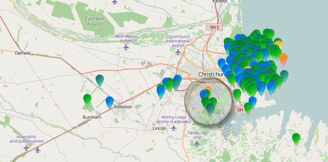
Another thing I noticed just now, when I zoomed in one level on that map,
the current sub series of aftershocks shape is almost a (smaller) duplicate of shape of the Lyttelton Volcano to the SSW, note the gap into the centre from the 5.7 epicentre from the NE, just like Lyttelton Harbour does
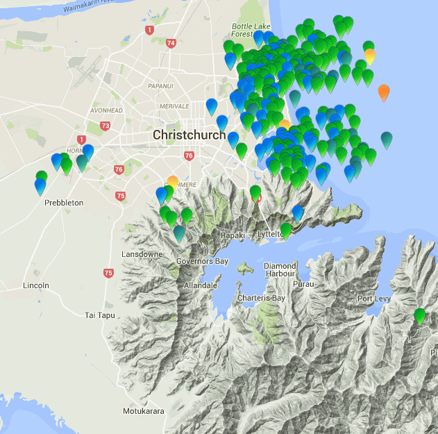
It may mean something,
or it could just be coincidence
rightclickviewimagestoseefullsize
new locations @ Christchurch - the suburb of Cashmere
started with a M2.4 on 27th 15:45, then a M2.8 ten minutes later
then a M4.3 approx 23 hrs after that, early this morning
followed by M2.7, M2.35 and a M3.0
Not sure what is happening with the Fault here, Cashmere is on the north side of the Port Hills,
not out East where the 5.7 (and the majority of the aftershocks) was on the 13th Feb
It's almost like it is tracking backwards in direction to the original source of this upheaval, Darfield (M7.1 Sept 4th 2011)
here's a map of the new area
Another thing I noticed just now, when I zoomed in one level on that map,
the current sub series of aftershocks shape is almost a (smaller) duplicate of shape of the Lyttelton Volcano to the SSW, note the gap into the centre from the 5.7 epicentre from the NE, just like Lyttelton Harbour does
It may mean something,
or it could just be coincidence
rightclickviewimagestoseefullsize
edit on 02000000595916 by muzzy because: (no reason given)
I thought this was interesting.
In 2001 a large CO spike occurred before a mag 7.6 earthquake shook the Gujara region.
Could this be a sign that Cali is gonna let one rip?
robertscribbler.com...
Here is another link that might be of interest.
www.natureasia.com...
In 2001 a large CO spike occurred before a mag 7.6 earthquake shook the Gujara region.
Could this be a sign that Cali is gonna let one rip?
robertscribbler.com...
Here is another link that might be of interest.
www.natureasia.com...
edit on 29-2-2016 by crappiekat because: to add
Of course I'm watching Central America too closely. I'm thinking every earthquake there is related to Mombotombo. Today, depending on which source you check, has had three bumps recently. Actually, the USGS was quicker on this last listing so I didn't have to guess.
earthquake.usgs.gov...
edit on 29-2-2016 by ericblair4891 because: (no reason
given)
originally posted by: crappiekat
I thought this was interesting.
In 2001 a large CO spike occurred before a mag 7.6 earthquake shook the Gujara region.
Could this be a sign that Cali is gonna let one rip?
robertscribbler.com...
Here is another link that might be of interest.
www.natureasia.com...
I just wanted to make an update. According to NASA site, this was due to fires.
At any rate. It was not good information.
Whatever made this happen, it sure was strange and interesting.
There was never any confirmation that this was real.
gmao.gsfc.nasa.gov...
edit on 2-3-2016 by crappiekat because: to add. Getting
forgetful
edit on 2-3-2016 by crappiekat because: to add
Major Earthquake - Sumatra
quakewatch.wordpress.com...
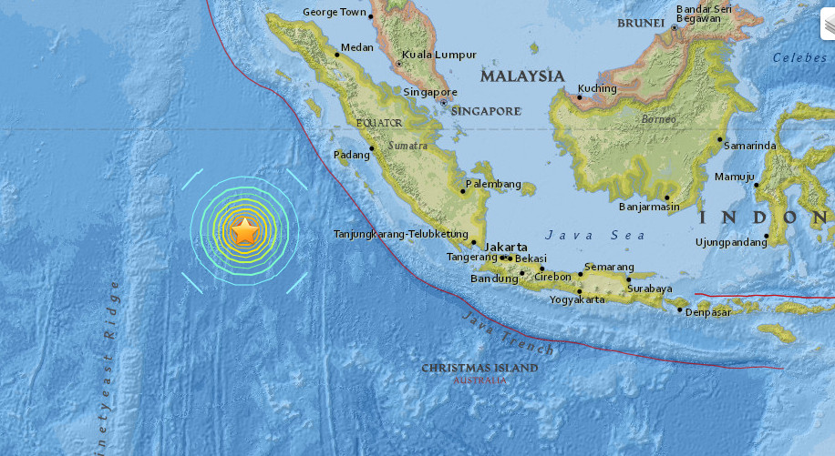
quakewatch.wordpress.com...
edit on 2/3/2016 by PuterMan because: To add map
new topics
-
12 jurors selected in Trump criminal trial
US Political Madness: 2 hours ago -
Iran launches Retalliation Strike 4.18.24
World War Three: 2 hours ago -
Israeli Missile Strikes in Iran, Explosions in Syria + Iraq
World War Three: 3 hours ago -
George Knapp AMA on DI
Area 51 and other Facilities: 8 hours ago -
Not Aliens but a Nazi Occult Inspired and then Science Rendered Design.
Aliens and UFOs: 9 hours ago -
Louisiana Lawmakers Seek to Limit Public Access to Government Records
Political Issues: 11 hours ago
top topics
-
BREAKING: O’Keefe Media Uncovers who is really running the White House
US Political Madness: 16 hours ago, 25 flags -
George Knapp AMA on DI
Area 51 and other Facilities: 8 hours ago, 24 flags -
Biden--My Uncle Was Eaten By Cannibals
US Political Madness: 17 hours ago, 18 flags -
Israeli Missile Strikes in Iran, Explosions in Syria + Iraq
World War Three: 3 hours ago, 12 flags -
"We're All Hamas" Heard at Columbia University Protests
Social Issues and Civil Unrest: 17 hours ago, 7 flags -
Louisiana Lawmakers Seek to Limit Public Access to Government Records
Political Issues: 11 hours ago, 7 flags -
So I saw about 30 UFOs in formation last night.
Aliens and UFOs: 14 hours ago, 5 flags -
Iran launches Retalliation Strike 4.18.24
World War Three: 2 hours ago, 5 flags -
Not Aliens but a Nazi Occult Inspired and then Science Rendered Design.
Aliens and UFOs: 9 hours ago, 4 flags -
The Tories may be wiped out after the Election - Serves them Right
Regional Politics: 12 hours ago, 3 flags
active topics
-
Israeli Missile Strikes in Iran, Explosions in Syria + Iraq
World War Three • 50 • : WeMustCare -
Max Loughan Boy Genius Or Something More?
Science & Technology • 69 • : SchrodingersRat -
Iran launches Retalliation Strike 4.18.24
World War Three • 13 • : TheMisguidedAngel -
The Tories may be wiped out after the Election - Serves them Right
Regional Politics • 21 • : glen200376 -
MULTIPLE SKYMASTER MESSAGES GOING OUT
World War Three • 45 • : Irishhaf -
George Knapp AMA on DI
Area 51 and other Facilities • 22 • : SchrodingersRat -
BREAKING: O’Keefe Media Uncovers who is really running the White House
US Political Madness • 15 • : BingoMcGoof -
Running Through Idiot Protestors Who Block The Road
Rant • 109 • : Astyanax -
12 jurors selected in Trump criminal trial
US Political Madness • 20 • : Lumenari -
Pfizer is 'deeply sorry'
Diseases and Pandemics • 23 • : VoiceofReality