It looks like you're using an Ad Blocker.
Please white-list or disable AboveTopSecret.com in your ad-blocking tool.
Thank you.
Some features of ATS will be disabled while you continue to use an ad-blocker.

Quake Watch 2016
page: 10share:
is it just me or has there been an overall increase of global activity in the last 24-12 hrs?? im going by whats reported in GImap.
the Number of quakes as i look in globalincidentmap -earthquakes firefox vs chrome are totally different anyone else get this discrepancy????
Sorry beta version vs non beta version never mind!!
the Number of quakes as i look in globalincidentmap -earthquakes firefox vs chrome are totally different anyone else get this discrepancy????
Sorry beta version vs non beta version never mind!!
edit on 4-2-2016 by GnosticMountain because: attention to detail
M3.5 - 13km N of Simmler, California
earthquake.usgs.gov...
Time
2016-02-04 07:20:58 (UTC)
2016-02-03 23:20:58 (UTC-08:00) in your timezone
Times in other timezones
Nearby Cities
13km (8mi) N of Simmler, California
40km (25mi) SE of Cholame, California
42km (26mi) ESE of Shandon, California
63km (39mi) SE of Parkfield, California
66km (41mi) ESE of Paso Robles, California
87km (54mi) W of Bakersfield, California
M3.4 - 7km WNW of Clancy, Montana
earthquake.usgs.gov...
Time
2016-02-04 07:46:59 (UTC)
2016-02-03 23:46:59 (UTC-08:00) in your timezone
Times in other timezones
Nearby Cities
7km (4mi) WNW of Clancy, Montana
11km (7mi) SSW of Helena, Montana
65km (40mi) NNE of Butte, Montana
120km (75mi) NW of Bozeman, Montana
126km (78mi) SSW of Great Falls, Montana
My :japanearthquake2: blog has been a total flop, this is the one that maps both M1+ and M~1 earthquake
events on the same page, with a double pie chart graphic each day. I have only had 81 views from 35 visitorssince Sept in 2015, and only 15 views from
1 visitor in 2016.
Not sure why Wordpress doesn't get the visitors?, compared to Blogger, which gets 20-45 a day, sometimes hundreds a day. If no one is going to read it, I might as well not waste my time making separate pie graphs and posting on Wordpress at all.
There must be others out there amongst the 7.4 billion ( World Pop. Clock ........ thats scary!!) who are interested in M~1 quakes in Japan, surely.
So I have started from Jan 1st 2016 putting that M~1 link on the daily :japanearthquakes: on Blogger.
Here is where it is;
There is always something happening in Japan earthquake wise.
Of course the reason I have to split out M~1 at all is because Bing only allows 200 markers per map, the average number of Japan quakes per day (map) is over 300 combined, so it won't work.
edit on 02000000353516 by muzzy because: (no reason given)
a reply to: Ivar_Karlsen
My guess is no. It would appear that the peak (of what we can see) has passed in terms of the highest energy output.
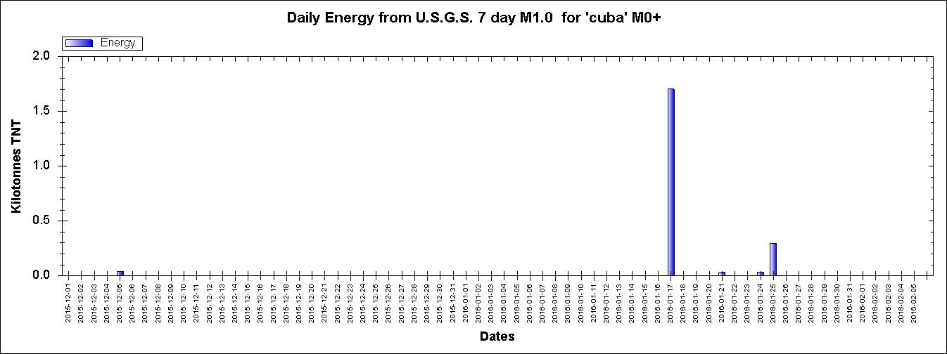
Click the image to enlarge
Not many quakes showing for the past year in IRIS Earthquake Browser (15)
IEB export: 15 earthquakes as a sortable table
My guess is no. It would appear that the peak (of what we can see) has passed in terms of the highest energy output.

Click the image to enlarge
Not many quakes showing for the past year in IRIS Earthquake Browser (15)
IEB export: 15 earthquakes as a sortable table
not to deep
USGS
6.4 EMSC
So far no deaths yet but significant damage is being reported.
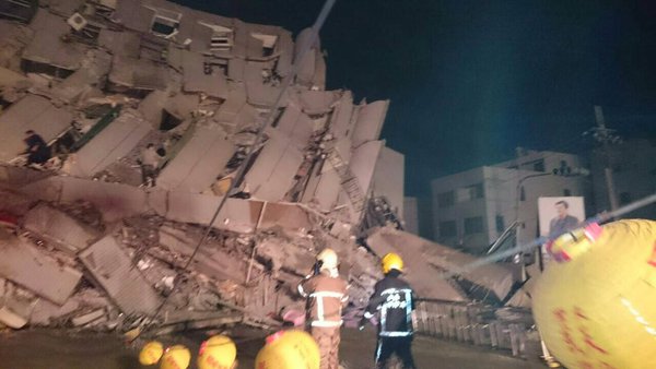
Source
M6.4 - 22km NE of Pingtung, Taiwan
22.900 °N 120.500 °E depth=10.0 km (6.2 mi)
Time
2016-02-05 19:57:30 (UTC)
2016-02-05 13:57:30 (UTC-06:00) in your timezone
Times in other timezones
Nearby Cities
22km (14mi) NE of Pingtung, Taiwan
36km (22mi) SSE of Yujing, Taiwan
39km (24mi) NE of Kaohsiung, Taiwan
45km (28mi) ESE of Tainan, Taiwan
667km (414mi) E of Hong Kong, Hong Kong
USGS
6.4 EMSC
edit on 5-2-2016 by lurksoften because: down graded 6.7 to
6.4
So far no deaths yet but significant damage is being reported.
Reuters reports that multiple buildings including a residential complex have collapsed in Taiwan. This earthquake is by far the most destructive of the recent years. A dangerous fault line runs through the middle of the island.
Source
edit on 5-2-2016 by lurksoften
because: (no reason given)
a reply to: lurksoften
www.cwb.gov.tw...
Central Weather Bureau have a nice KMZ file for those with Google Earth, shows historic quakes as well as Intensity of this one.
www.cwb.gov.tw...
www.cwb.gov.tw...
Central Weather Bureau have a nice KMZ file for those with Google Earth, shows historic quakes as well as Intensity of this one.
www.cwb.gov.tw...
edit on 02000000353516 by muzzy because: (no reason
given)
a reply to: muzzy
Muzzy!!! That's not true. I always go and check out your page. And I go and look stuff up sometimes, when I want to compare stuff.
Some of the pages won't let me look, because of that message I get. " subscriber something something etc." I just figured maybe they were old pages and you moved the information, so I will go back and look for another link.
a reply to: lurksoften
When I saw this earthquake, I remembered this article.
theconversation.com...
I know it's a different fault, but...
When I saw this earthquake, I remembered this article.
theconversation.com...
I know it's a different fault, but...
Scrapped. It was incorrect.
edit on 6/2/2016 by PuterMan because: rubbish speak
a reply to: lurksoften
That video on Earthquake Report showing the two high rise buildings that tipped over is pretty amazing.
See that a lot in Asian earthquakes, makes me think they need to review their Foundation Engineering.
Not sure which would be worse, that or pancaking, I guess the chances of surviving a tip-over would be greater, sort of ride it down to the ground.
earthquake-report.com...
edit on 02000000363616 by muzzy because: (no reason given)
a reply to: crappiekat
Yes I recall you liked the Pacman type pies, as I did. Trouble is I can't get them to show on Blogger at the same scale, they come out small and the text is blurred.
The M~1 data and mapping is still there (on the Blogger pages) just no graphic (pie).
Yes I recall you liked the Pacman type pies, as I did. Trouble is I can't get them to show on Blogger at the same scale, they come out small and the text is blurred.
The M~1 data and mapping is still there (on the Blogger pages) just no graphic (pie).
a reply to: muzzy
JMA gave the Taiwan quake 6.4 based on Displacement. and 6.7 based on Velosity
China Earthquake Networks Center (CENC) gave it 6.8Ms on the Chinese list and 6.7 on the World Data Center for Seismolgy, Beijing
JMA gave the Taiwan quake 6.4 based on Displacement. and 6.7 based on Velosity
China Earthquake Networks Center (CENC) gave it 6.8Ms on the Chinese list and 6.7 on the World Data Center for Seismolgy, Beijing
edit on 02000000373716 by muzzy because: (no reason given)
a reply to: muzzy
Looking at what I see.
I am watching Napal.
Sorry, didn't have link. Here we go.
www.emsc-csem.org...
Looking at what I see.
I am watching Napal.
Sorry, didn't have link. Here we go.
www.emsc-csem.org...
edit on 7-2-2016 by crappiekat because: (no reason given)
a reply to: muzzy
Wasn't sure if you were going to add the links later.
USGS
EMSC Mw 6.5
Wasn't sure if you were going to add the links later.
M6.3 - 94km WSW of Panguna, Papua New Guinea
6.636 °S 154.693 °E depth=30.6 km (19.0 mi)
Time
2016-02-08 16:19:12 (UTC)
2016-02-08 10:19:12 (UTC-06:00) in your timezone
Times in other timezones
Nearby Cities
94km (58mi) WSW of Panguna, Papua New Guinea
104km (65mi) WSW of Arawa, Papua New Guinea
369km (229mi) SE of Kokopo, Papua New Guinea
517km (321mi) ESE of Kimbe, Papua New Guinea
656km (408mi) WNW of Honiara, Solomon Islands
USGS
EMSC Mw 6.5
Well Puterman, you really should put something together and get the rest of those geology guys and girls to realize that storms in the Atlantic set
off the rift. Again, there is a series of earthquakes in the mid-Atlantic, and once again, there is a big ass storm just to the east of the ridge.
Let's remember storms are proceeded by a surge. So, the pressure, and the wave action, must change the stresses on the ridge and this causes
earthquakes.
While I'm out here, Northern Nevada has calmed down a bit. Only a dozen or so in the last week. Challis, Idaho has almost as many for the same period.
WOW, i have some time in the time window to edit. As soon as I pipe up about northern Nevada finally quieting down, a small 2.5m pops off and makes me a liar. Still, it's not exactly as it once was.
edit on 8-2-2016 by ericblair4891 because: (no reason given)
Public ID 2016p105478
Intensity strong
Universal Time February 9 2016, 0:39:00
NZ Daylight Time Tue, Feb 9 2016, 1:39:00 pm
Depth 48 km
Magnitude 5.75
Location 35 km south-east of St Arnaud
Latitude, Longitude -42.0683, 173.0748
Agency WEL(GNS_Primary)
www.geonet.org.nz...
3600 felt reports, from Dunedin to Auckland. (always suspicious of those Auckland one though)
I didn't feel it, was driving on the highway at the time
6,252.56 TTNT energy released
Looked like the Awatere Fault, but then had a look on data.gns.cri.nz...#
its on an un-named fault 4.4km north of Awatere Fault
Depending on the accuracy of the location data,
USGS has it 5.2 Mwr, but 2km SOUTH of the Awatere Fault ( almost same longitude though)
Intensity strong
Universal Time February 9 2016, 0:39:00
NZ Daylight Time Tue, Feb 9 2016, 1:39:00 pm
Depth 48 km
Magnitude 5.75
Location 35 km south-east of St Arnaud
Latitude, Longitude -42.0683, 173.0748
Agency WEL(GNS_Primary)
www.geonet.org.nz...
3600 felt reports, from Dunedin to Auckland. (always suspicious of those Auckland one though)
I didn't feel it, was driving on the highway at the time
6,252.56 TTNT energy released
edit on 02000000383816 by muzzy because: (no reason given)
Looked like the Awatere Fault, but then had a look on data.gns.cri.nz...#
its on an un-named fault 4.4km north of Awatere Fault
Depending on the accuracy of the location data,
USGS has it 5.2 Mwr, but 2km SOUTH of the Awatere Fault ( almost same longitude though)
edit on 02000000383816 by muzzy because: (no reason
given)
new topics
-
The Baloney aka BS Detection Kit
Social Issues and Civil Unrest: 1 hours ago -
Suspected Iranian agent working for Pentagon while U.S. coordinated defense of Israel
US Political Madness: 1 hours ago -
How does my computer know
Education and Media: 4 hours ago -
USO 10 miles west of caladesi island, Clearwater beach Florida
Aliens and UFOs: 8 hours ago
top topics
-
USO 10 miles west of caladesi island, Clearwater beach Florida
Aliens and UFOs: 8 hours ago, 6 flags -
Abortions in first 12 weeks should be legalised in Germany, commission says
Medical Issues & Conspiracies: 17 hours ago, 5 flags -
Suspected Iranian agent working for Pentagon while U.S. coordinated defense of Israel
US Political Madness: 1 hours ago, 3 flags -
How does my computer know
Education and Media: 4 hours ago, 1 flags -
The Baloney aka BS Detection Kit
Social Issues and Civil Unrest: 1 hours ago, 1 flags
active topics
-
NYAG Letitia James Prepares to Begin Seizing TRUMP Assets Even Though There Was No Crime.
Above Politics • 274 • : Threadbarer -
How does my computer know
Education and Media • 7 • : Encia22 -
Suspected Iranian agent working for Pentagon while U.S. coordinated defense of Israel
US Political Madness • 2 • : ImagoDei -
It has begun... Iran begins attack on Israel, launches tons of drones towards the country
World War Three • 627 • : ImagoDei -
Are the 'Abrahamic Religions' all Really the Worshipping the Same Abrahamic God?
Conspiracies in Religions • 173 • : FlyersFan -
The Acronym Game .. Pt.3
General Chit Chat • 7712 • : bally001 -
Candidate TRUMP Now Has Crazy Judge JUAN MERCHAN After Him - The Stormy Daniels Hush-Money Case.
Political Conspiracies • 188 • : Threadbarer -
The Baloney aka BS Detection Kit
Social Issues and Civil Unrest • 1 • : CosmicFocus -
Negotiations and Diplomacy.
History • 12 • : BrotherKinsMan -
Russia Ukraine Update Thread - part 3
World War Three • 5690 • : F2d5thCavv2