It looks like you're using an Ad Blocker.
Please white-list or disable AboveTopSecret.com in your ad-blocking tool.
Thank you.
Some features of ATS will be disabled while you continue to use an ad-blocker.

Study into folklore shows a 7000yr old link to the past.
page: 1share:
A fascinating study into indigenous Australian folk stories suggests that some tales could easily be 7000 years old, or more.
Professor Nunn stated:
I find this a remarkable study, with no real reason to doubt the validity of the findings. We can be too quick to dismiss our own folklore as ‘just stories’, but all stories are passed down for a reason. I believe that all of our ancient tales have in their heart a truth of the time they first came into existence and we would be wise to listen to them. I find it very difficult to believe that they could exist in one culture, exclusively. So how old are our stories really?
The research paper ‘Aboriginal memories of inundation of the Australian coast dating from more than 7,000 years ago’ can be viewed online for a limited time (but I’m not sure how long for, so look now if you want to catch it).
Hope you enjoy it as much as I did.
B x
Past Horizons
Abstract and link to pdf
Aboriginal society has preserved memories of Australia’s coastline dating back more than 7,000 years. That’s the conclusion that University of the Sunshine Coast Professor of Geography Patrick Nunn reached in a paper published in Australian Geographer.
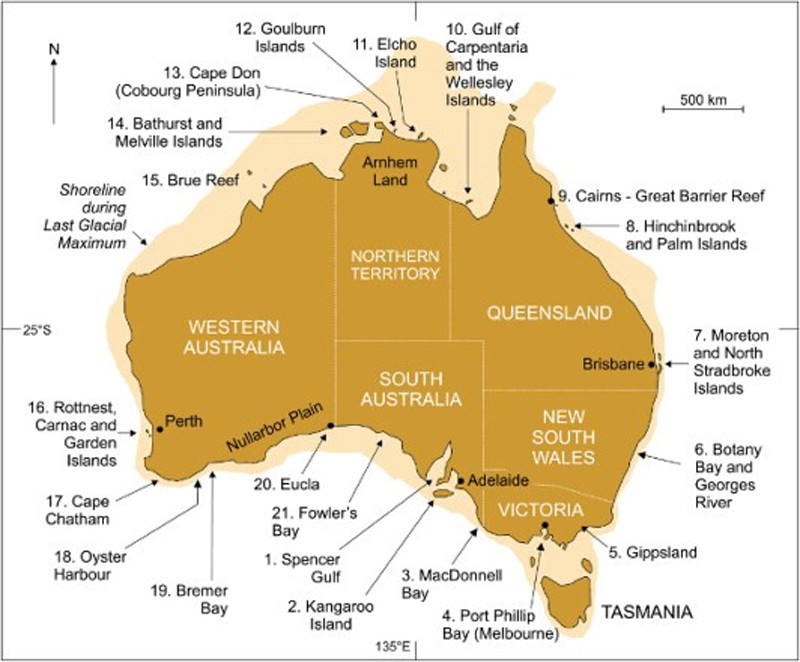
The study looks at Aboriginal stories from 21 places around Australia’s coastline, each describing a time when sea levels were significantly lower than today. Professor Nunn said present sea levels in Australia were reached 7,000 years ago and as such any stories about the coastline stretching much further out to sea had to pre-date that time.
“These stories talk about a time when the sea started to come in and cover the land, and the changes this brought about to the way people lived – the changes in landscape, the ecosystem and the disruption this caused to their society,” he said.
“It’s important to note that it’s not just one story that describes this process. There are many stories, all consistent in their narrative, across 21 diverse sites around Australia’s coastline.”
Professor Nunn stated:
“Anything that goes back thousands of years – nearly 10,000 years in some cases – has to be quite exceptional,” he said.
“It’s a remarkable time period when we consider our own memories and what we can remember even with the aid of books and other information.
“I believe these stories endured that long partly due to the harshness of Australia’s natural environment, which meant that each generation had to pass on knowledge to the next in a systematic way to ensure its survival.”
I find this a remarkable study, with no real reason to doubt the validity of the findings. We can be too quick to dismiss our own folklore as ‘just stories’, but all stories are passed down for a reason. I believe that all of our ancient tales have in their heart a truth of the time they first came into existence and we would be wise to listen to them. I find it very difficult to believe that they could exist in one culture, exclusively. So how old are our stories really?
The research paper ‘Aboriginal memories of inundation of the Australian coast dating from more than 7,000 years ago’ can be viewed online for a limited time (but I’m not sure how long for, so look now if you want to catch it).
Hope you enjoy it as much as I did.
B x
Past Horizons
Abstract and link to pdf
a reply to: beansidhe
Fascinating. Thanks.
Thinking about it, folklore was THE preliterate way to pass important information on to succeeding generations and injecting false or unimportant information can then be seen as fairly sociopathic...
So... all those gods, stories, dreamtime, etc., must be based on something people experienced ... or there were people in important leadership positions who were not very nice to the succeeding generations and used the "storage space" for cultural information as, basically, a creative writing hobby...
Hmmm... well... nevermind... in that light it might well all be bull poop... people seeking to lead are indeed crazy... sorry for the self-referential post.
But what a cool study!
Edit: but I was being fairly flip... of course folklore held important information or we wouldn't be here... but that information includes important metaphor about human behavior, too... so back to inconclusiveness about "literal" folklore validity ; ]
edit on 9/18/2015 by Baddogma because:
add
a reply to: Baddogma
Hello, how nice to 'see' you!
You make an excellent point - he who tells the story, has a lot of power. How they choose to wield it is another thing all together. Presumably all useful tales survive..but then useful to whom? In a society who depend on each other to survive, it would be hoped that the stories remain helpful but factions develop, clans are formed..well, I digress.
The stories we have left speak volumes about us, and at the same time keep us in the dark about so much of our history. Maybe why I love this subject so much! Hope all is well with you, and yes I agree, it's a very cool study.
B x
Related to this is a plaque I saw at Lake Bolac a few years ago. The plaque actually said that the lava flow had been rcorded in thier folklore but
this is all I could find on the net.
"The freshwater lake was created when recent lava flows from the local volcanic cones altered the flow and dammed the former bed of the Fiery Creek, creating a depression which filled to form the lake. These lava flows also formed the bluestone banks to the north of the town. The volcanic eruptions occurred approximately 20,000 years ago, within the dreamtime of the Boolucburrers."
lakebolac.com.au...
* Off topic is the interesting story of the eels of Lake Bolac:
In the middle of the Victorian Volcanic Plains (South Eastern Australia) there is a vast body of water called Lake Bolac. Lake Bolac was formed around 20,000 years ago through volcanic eruptions. Lava flows dammed the river creating an enormous shallow teardrop shaped depression that filled with water, the shoreline of Lake Bolac is 27 kilometres long.
Eels have migrated along a strange but steady path to reach the waters of Lake Bolac. The life cycle of the numerous eels that inhabit the rivers, streams, lakes, swamps and estuaries of the plains is an epic story.When they reach breeding age, which can be anywhere between five and thirty years, mature eels swim out of the rivers around Australia, including western Victoria and head along the Australian continental shelf to the seas around northern Queensland and Papua New Guinea, several thousand kilometers away, where they breed and die. The young eels, called elvers, are transparent and leaf shaped. They take a couple of years to return to the rivers of the south east coast of Australia, Tasmania and New Zealand. Then, usually in early Autumn, they swim up the rivers and even slide across damp ground to find a home in the still fresh waters of lakes and wetlands, including those on the plains.
From the ocean the eels must cross 100 kilometres of land to reach Lake Bolac. Aboriginal people built a vast aquaculture system from the volcanic stones along the shores of the lake, trapping and harvesting the eels. For at least eight thousand years (most probably a lot longer) in Autumn people gathered for a festival of eels. Mainly to eat them. The organisers of the festival built an enormous stone arrangement in the shape of an eel, the size of a football field, by shifting massive boulders into position. Eels are thought to have been traded widely among Aboriginal groups, forming the basis of a sedentary society.
When Europeans invaded Australia the eel festivities and systems of aquaculture ceased for around 150 years. A highway was built through the middle of the giant stone eel. Eels are still caught and traded now, and exported as far afield as Germany and Korea. The largest eel processing plant in the southern Hemisphere is situated at a small rural town called Skipton, on the Glenelg Highway.The eel festival resumed in 2004 and is organised by a committee of local people of both Aboriginal and European descent. www.kerriepoliness.com...
a reply to: beansidhe
Star and flag nice thread, I would venture to say the story's have a reality, and that like said in my other thread have potential manifesting power.
why do we share so many stock characters and plots cross culturally? One may not see it but when I say devil, I also say trickster, snake, fox, joker, and one and on. The way this character appears in story's is different, however the basic archetype and construction of persona is the same cross culturally.
this is extremely interesting and of course many many more examples can be given. I think there is a a parallel flow of information yet unaccessible to science. It is called the collective unconscious. Anyway great thread thanks for posting.
edit on 19-9-2015 by TechniXcality because: (no
reason given)
a reply to: Cinrad
Thank for that Cinrad - 20,000 years seems fantastic initially and yet when coupled with Nunn's research, it seems perfectly reasonable. Just reading the sentence "a highway was built through the middle of the giant stone eel" made me want to cry. 8000+ years of tradition gone in an instant. Thankfully the festival resumed.
Thank for that Cinrad - 20,000 years seems fantastic initially and yet when coupled with Nunn's research, it seems perfectly reasonable. Just reading the sentence "a highway was built through the middle of the giant stone eel" made me want to cry. 8000+ years of tradition gone in an instant. Thankfully the festival resumed.
a reply to: TechniXcality
Well thank you, Tech, it's always nice to hear your comments! I like Jung too, even though he's not as groovy as he once was. My only counter to his claim of the collective unconscious -which I quite like - is that in his day, it would have been ridiculous to suggest that there had been widespread cross-cultural contact. My view is, I'm not so sure.
That is definitely possible, and even within my own family there are lots of stories about 'psychic' transfer of information so I'm not so arrogant as to dismiss it out of hand.
That the stories create a reality of their own is where things get too clever for me, and my mind starts to melt. Is imagination 'real'? Yes, no, sort of? I venture 'yes' - and so another track gets followed... All good stuff to ponder.
Well thank you, Tech, it's always nice to hear your comments! I like Jung too, even though he's not as groovy as he once was. My only counter to his claim of the collective unconscious -which I quite like - is that in his day, it would have been ridiculous to suggest that there had been widespread cross-cultural contact. My view is, I'm not so sure.
this is extremely interesting and of course many many more examples can be given. I think there is a a parallel flow of information yet unaccessible to science.
That is definitely possible, and even within my own family there are lots of stories about 'psychic' transfer of information so I'm not so arrogant as to dismiss it out of hand.
That the stories create a reality of their own is where things get too clever for me, and my mind starts to melt. Is imagination 'real'? Yes, no, sort of? I venture 'yes' - and so another track gets followed... All good stuff to ponder.
This reminds me of Dunwich, an east Anglia coastal town which fell into the sea in the 1300s.
I first heard the folk stories from local fishermen around 1980 who would tell of the tolling of ghostly bells from the submerged churches in the bay off the coast, which was used as a storm prediction.
So when the internet became available, it became more than a folk story and even has its own Wikipedia page
en.wikipedia.org...
confirmed by recent marine archaeology
www.visitsouthwold.co.uk...
I don't expect the folklore will vanish, its still accurate and remained so by word of mouth for 700 years
I first heard the folk stories from local fishermen around 1980 who would tell of the tolling of ghostly bells from the submerged churches in the bay off the coast, which was used as a storm prediction.
So when the internet became available, it became more than a folk story and even has its own Wikipedia page
en.wikipedia.org...
A popular local legend says that, at certain tides, church bells can still be heard from beneath the waves.
On 1 January 1286, a storm surge reached the east edge of the town and destroyed buildings in it. Before that, most recorded damage to Dunwich was loss of land and damage to the harbour.
This was followed by two further surges the next year, the South England flood of February 1287 and St. Lucia's flood in December. A fierce storm in 1328 also swept away the entire village of Newton, a few miles up the coast. Another large storm in 1347 swept some 400 houses into the sea. The Grote Mandrenke around 16 January 1362 finally destroyed much of the remainder of the town.[
confirmed by recent marine archaeology
www.visitsouthwold.co.uk...
I don't expect the folklore will vanish, its still accurate and remained so by word of mouth for 700 years
a reply to: Marduk
Hi Marduk, thank you for that story. It's an excellent example of a survival tale - it would behoove the fishermen and their families to remember the damage done by storms in the area, and the tragedy that can unfold in the blink of an eye.
I then start thinking about the Tuatha de Danaan who came from 'the west', and all the other lore we still have today and wonder how much is metaphor, and how much is...well, real?
a reply to: beansidhe
Nice to type at you, too. Hope your real life is as good as you want it to be.
I didn't bother with social niceties because A) I'm a Philistine and B) I have been reading your stuff and it didn't seem like a discontinuity from my perspective and C) I didn't want to presume you remembered me and D) I didn't want to litter your lovely little thread with posts like this one! : 0
But folklore is our only window into our past ...and of course it holds good information, as stated. Once the written word happened any yahoo with an opinion got to be immortalized... before that, it was sort of the only game in town and very, very important.
Which is why I, too, find some fascinating things in it... along with some weird characters coming from the "West."
And seeing how I have experienced things better explained by nonrandom fluctuation in the space time continuum... or a wily trickster god... or a drunk grand 'watchmaker'... I think we relegate all folklore to the "quaint but ignorant" bin at our peril.
But I wish I understood the context and nuance of language in the world's folklore a bit more... I'm not entirely certain anyone alive today can know what was really being said in them all, precisely, either.
a reply to: Baddogma
It's all I can do not to resurrect your old thread! And you couldn't litter a thread if you tried.
Not to get too far off topic, but just to go back to the Tuatha for a minute, it is said that when the Milesians came over they said 'we'll share the land with you - we can live above ground, and you can live below'. I'm paraphrasing slightly. But now say that with an Irish (Milesian lol) accent. To my ears, in my culture and in my ears that sounds like a threat.
Aye, we'll live up here and we'll put you under it! Ha ha ha, or however Milesians laughed. In other words, they slaughtered them.
So we're left with tales where we struggle with the meanings of each word unless the content is explicit, such as Marduk's more modern tale above. So many words have changed their meaning over time - awful is the first one that comes to mind - some have vanished, some have grown arms and legs. If every sentence is a tapestry of meaning and nuance what can be said of a whole story that has lasted millenia?
So while I agree with you, I agree more with you when you say " I think we relegate all folklore to the "quaint but ignorant" bin at our peril."
We just need to know what we're looking for - and therein lies the rub.
It's all I can do not to resurrect your old thread! And you couldn't litter a thread if you tried.
But I wish I understood the context and nuance of language in the world's folklore a bit more... I'm not entirely certain anyone alive today can know what was really being said in them all, precisely, either.
Not to get too far off topic, but just to go back to the Tuatha for a minute, it is said that when the Milesians came over they said 'we'll share the land with you - we can live above ground, and you can live below'. I'm paraphrasing slightly. But now say that with an Irish (Milesian lol) accent. To my ears, in my culture and in my ears that sounds like a threat.
Aye, we'll live up here and we'll put you under it! Ha ha ha, or however Milesians laughed. In other words, they slaughtered them.
So we're left with tales where we struggle with the meanings of each word unless the content is explicit, such as Marduk's more modern tale above. So many words have changed their meaning over time - awful is the first one that comes to mind - some have vanished, some have grown arms and legs. If every sentence is a tapestry of meaning and nuance what can be said of a whole story that has lasted millenia?
So while I agree with you, I agree more with you when you say " I think we relegate all folklore to the "quaint but ignorant" bin at our peril."
We just need to know what we're looking for - and therein lies the rub.
a reply to: beansidhe
Hi Beansidhe,
Nice post once again.
I have personally long believed that much of mythology is based on real world events wrapped up in metaphors as time and a distance separate the story teller from original events.
Also it's the truely unique events that get rembered in lore, huge floods ,volcanoes comets and impacts will leave am imprint on a society for millennia.
Bruce Masse wrote a very good paper on the subject of myth as an account of actual happenings.
Exploring the nature of myth and its role in science
And his very important
Myth and catastrophic reality: using myth to identify cosmic impacts and massive Plinian eruptions in Holocene South America
Hi Beansidhe,
Nice post once again.
I have personally long believed that much of mythology is based on real world events wrapped up in metaphors as time and a distance separate the story teller from original events.
Also it's the truely unique events that get rembered in lore, huge floods ,volcanoes comets and impacts will leave am imprint on a society for millennia.
Bruce Masse wrote a very good paper on the subject of myth as an account of actual happenings.
The scientific study of myth is dominated by a paradigm that recognizes myth as having been viewed as truthful narrative history by past traditional cultures and yet is considered false or otherwise suspect by the modern scholars who study myth. Although virtually all scholars recognize that myth was of critical importance for traditional cultures, the attempt to elicit scientific reasons for this importance has led to many competing theories, few of which place an emphasis on the validity of myths as representing the product of actual observed historical natural events. This paradox may hinder our understanding of the origins of myth and prevent us from fully appreciating a critical aspect of why myth was so highly valued by past cultures. To set the stage for our examination of the possible natural history core of myth, we discuss briefly the history of the western scientific study of myth, with an emphasis on geological sciences. We then explore the cognitive structure of myth and provide working principles about how the historical information contained in these myths can be transmitted faithfully through successive generations and can be elicited by scientific study. Although recognizing the extreme complexity of myth as a cultural product, our data indicate that a science-based natural history approach can lead to important insights regarding the nature of myth.
Exploring the nature of myth and its role in science
And his very important
Myth and catastrophic reality: using myth to identify cosmic impacts and massive Plinian eruptions in Holocene South America
Abstract
Major natural catastrophes such as floods, fire, darkness, and ‘sky falling down’ are prominently reflected in traditional South American creation myths, cosmology, religion, and worldview. Cosmogonic myths represent a rich and largely untapped data set concerning the most dramatic natural events and processes experienced by cultural groups during the past several thousand years. Observational details regarding specific catastrophes are encoded in myth storylines, typically cast in terms of supernatural characters and actions. Not only are the myths amenable to scientific analysis, some sets of myths encode multiple catastrophes in meaningful relative chronological order. The present study considers 4259 myths, including 284 ‘universal’ (perceived in the narratives to be worldwide) catastrophe myths, from 20 cultural groups east of the Andes. These myths are examined in light of available geological, palaeoenvironmental, archaeological, and documentary evidence. Our analysis reveals three likely major Plinian volcanic eruptions in Columbia and the Gran Chaco. We also identify a set of traditions that are probably linked to the well-known Campo del Cielo iron meteorite impact in northern Argentina around 4000 years ago, along with a separate set of traditions alluding to a possible airburst in the Brazilian Highlands. These impacts apparantly triggered widespread mass fires. There are hints of cosmic impacts in the mythologies for other locations in South America.
a reply to: punkinworks10
Hello there P, and thank you very much! Wow, thanks for those 2 links.
I'm going to enjoy reading these! Hope all is good with you.
eta - They're going to charge me $60 for both articles online.
I'll need to pick one this month and come back for the other one next month.
Hello there P, and thank you very much! Wow, thanks for those 2 links.
We also identify a set of traditions that are probably linked to the well-known Campo del Cielo iron meteorite impact in northern Argentina around 4000 years ago, ...
I'm going to enjoy reading these! Hope all is good with you.
eta - They're going to charge me $60 for both articles online.
I'll need to pick one this month and come back for the other one next month.
edit on 19-9-2015 by beansidhe because: eta
originally posted by: beansidhe
A fascinating study into indigenous Australian folk stories suggests that some tales could easily be 7000 years old, or more.
Aboriginal society has preserved memories of Australia’s coastline dating back more than 7,000 years. That’s the conclusion that University of the Sunshine Coast Professor of Geography Patrick Nunn reached in a paper published in Australian Geographer.
The study looks at Aboriginal stories from 21 places around Australia’s coastline, each describing a time when sea levels were significantly lower than today. Professor Nunn said present sea levels in Australia were reached 7,000 years ago and as such any stories about the coastline stretching much further out to sea had to pre-date that time.
“These stories talk about a time when the sea started to come in and cover the land, and the changes this brought about to the way people lived – the changes in landscape, the ecosystem and the disruption this caused to their society,” he said.
“It’s important to note that it’s not just one story that describes this process. There are many stories, all consistent in their narrative, across 21 diverse sites around Australia’s coastline.”
I find the map interesting. When we look at the ocean depths between Victoria and Tasmania, centrally, the Bass Strait is about 250 to 300 feet. Toward the Western and Eastern edges, they drop off from around 600 to 1200 feet to 5000 feet in depth! The Northern map view, the boundary would touch the beaches of Papua New Guinea, Papua, and the islands south of Indonesia.
originally posted by: Violater1
[I find the map interesting. When we look at the ocean depths between Victoria and Tasmania, centrally, the Bass Strait is about 250 to 300 feet. Toward the Western and Eastern edges, they drop off from around 600 to 1200 feet to 5000 feet in depth! The Northern map view, the boundary would touch the beaches of Papua New Guinea, Papua, and the islands south of Indonesia.
Try this
Should illustrate your point nicely,
The guy who made that has a whole series of similar videos here
www.youtube.com...
must be some kind of precog genius
a reply to: Violater1
Hello Violater1, do you know I hadn't really considered that aspect at all? Now you point that out, I can see just how much land - the North in particular -has been lost. We're becoming much more isolated as the seas rise, an obvious point, but one which makes more sense out of ancient cross-cultural contact.
The figures you give there suggest a massive sea rise - many thanks for that info.
originally posted by: beansidhe
a reply to: Violater1
Hello Violater1, do you know I hadn't really considered that aspect at all? Now you point that out, I can see just how much land - the North in particular -has been lost. We're becoming much more isolated as the seas rise, an obvious point, but one which makes more sense out of ancient cross-cultural contact.
The figures you give there suggest a massive sea rise - many thanks for that info.
At the end of the last glacial maximum, there was a period of rapid thaw which led to the submersion of what is called the Sundaland: an area of low lying grassland that linked many of the southeast Asia islands while all the waters were locked up in ice "up North. That was around 12,000 years ago. Sea levels continued to rise globally over the next few thousand years as the glaciers retreated and Australia became completely isolated. Stephen Oppenheimer's East is Eden is a study of the folklore of South Asia, comparative to Western lore, and he found the greatest concentration of flood myths in the southeast Asian islands.
edit on 20-9-2015 by Anaana because: stray bracket
a reply to: Anaana
Thank you very much, Anaana. This is a geography that I know absolutely nothing about, so it's great to hear from everyone here that Nunn's research is really just a small link in an already strong chain.
I've just bought Oppenheimer's book from Amazon (for £7 I should add - a bargain) and I'm really looking forward to reading it.
new topics
-
University of Texas Instantly Shuts Down Anti Israel Protests
Education and Media: 1 hours ago -
Any one suspicious of fever promotions events, major investor Goldman Sachs card only.
The Gray Area: 3 hours ago -
God's Righteousness is Greater than Our Wrath
Religion, Faith, And Theology: 8 hours ago -
Electrical tricks for saving money
Education and Media: 11 hours ago
top topics
-
VP's Secret Service agent brawls with other agents at Andrews
Mainstream News: 12 hours ago, 10 flags -
Cats Used as Live Bait to Train Ferocious Pitbulls in Illegal NYC Dogfighting
Social Issues and Civil Unrest: 16 hours ago, 8 flags -
Nearly 70% Of Americans Want Talks To End War In Ukraine
Political Issues: 13 hours ago, 4 flags -
Sunak spinning the sickness figures
Other Current Events: 13 hours ago, 4 flags -
Electrical tricks for saving money
Education and Media: 11 hours ago, 4 flags -
Late Night with the Devil - a really good unusual modern horror film.
Movies: 15 hours ago, 2 flags -
Any one suspicious of fever promotions events, major investor Goldman Sachs card only.
The Gray Area: 3 hours ago, 2 flags -
University of Texas Instantly Shuts Down Anti Israel Protests
Education and Media: 1 hours ago, 1 flags -
God's Righteousness is Greater than Our Wrath
Religion, Faith, And Theology: 8 hours ago, 0 flags
active topics
-
University of Texas Instantly Shuts Down Anti Israel Protests
Education and Media • 6 • : CriticalStinker -
Sunak spinning the sickness figures
Other Current Events • 14 • : Ohanka -
British TV Presenter Refuses To Use Guest's Preferred Pronouns
Education and Media • 147 • : Annee -
Nearly 70% Of Americans Want Talks To End War In Ukraine
Political Issues • 41 • : andy06shake -
New whistleblower Jason Sands speaks on Twitter Spaces last night.
Aliens and UFOs • 56 • : pianopraze -
So this is what Hamas considers 'freedom fighting' ...
War On Terrorism • 260 • : network dude -
Hate makes for strange bedfellows
US Political Madness • 43 • : network dude -
Any one suspicious of fever promotions events, major investor Goldman Sachs card only.
The Gray Area • 7 • : seekshelter -
-@TH3WH17ERABB17- -Q- ---TIME TO SHOW THE WORLD--- -Part- --44--
Dissecting Disinformation • 663 • : MetalThunder -
Russia Ukraine Update Thread - part 3
World War Three • 5731 • : Freeborn