It looks like you're using an Ad Blocker.
Please white-list or disable AboveTopSecret.com in your ad-blocking tool.
Thank you.
Some features of ATS will be disabled while you continue to use an ad-blocker.

The "un-official" first flight of the U2 and a little Area 51 history
page: 15
share:
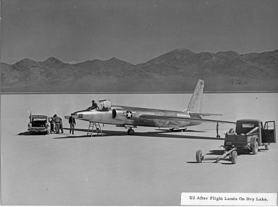
60 years and 5 days ago, Lockheed's chief test pilot, Tony LeVier accidentally recorded the first flight of the U2. He was supposed to perform a high
speed taxi test at 70 knots on a dry lake bed that we all know today as Area 51. As he was performing the test, the aircraft began to rise and before
he realized it was some distance off the ground. He was able to bring it back down but not without a little drama:
The article goes on to explain the history of Area 51 and the meaning behind some of the more common nick names for this legendary piece of land:
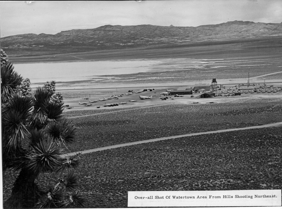
View of "Watertown" from the East side of Papoose Mt.:
www.cia.gov...
LeVier who had conducted the first taxi-test a few days prior, accelerated the U-2 to 70 knots when he suddenly realized he was airborne, leaving him in “utter amazement.”
“I had no intentions whatsoever of flying,” recalled LeVier in transcripts quoted in “The CIA and Overhead Reconnaissance – the U-2 and OXCART Program, 1954-1974 (PDF 16.56MB)” written by CIA Historians. “I immediately started back toward the ground, but had difficulty determining my height because the lakebed had no markings to judge distance or height. I made contact with the ground in a left bank of approximately 10 degrees.”
He was unable to land the U-2 on his first attempt, and it bounced back into the air, but he managed to successfully bring it down on a second try. Damage to the prototype U-2 was very minor. This test would later be considered the first unofficial flight of the U-2.
LeVier piloted the U-2’s first official test flight a few days later on August 4th, and the first official flight with visiting dignitaries present was on August 8th.
The article goes on to explain the history of Area 51 and the meaning behind some of the more common nick names for this legendary piece of land:
The strip of wasteland was known at the time by its map designation: Area 51. To make the new facility sound more attractive to the pilots and workers who would reside there, Lockheed’s famous aeronautical engineer, Clarence “Kelly” Johnson, called it “Paradise Ranch,” which was soon shortened to just “the Ranch.” Many of the workers even referred to themselves as “ranch hands.”
View of "Watertown" from the East side of Papoose Mt.:
www.cia.gov...
edit on
6-8-2015 by Sammamishman because: (no reason given)
edit on 6-8-2015 by Sammamishman because: (no reason given)
One of the joys of the Dragon Lady. She's a real bitch, in more ways than one. She'll takeoff at almost taxi speed for another aircraft, has crap for
downward visibility with the suit on, and will overspeed and fall apart if you don't treat her like a lady.
But you won't find much better for doing her job anywhere.
But you won't find much better for doing her job anywhere.
a reply to: Sammamishman
Of course, the statement that "The strip of wasteland was known at the time by its map designation: Area 51," is in error. That designation was assigned several years later when EG&G began moving the company's radar signature measurement range to Groom Lake from Indian Springs. There never was any map grid having the number 51 associated with the Groom Lake area. Otherwise, a reasonably good article.
Of course, the statement that "The strip of wasteland was known at the time by its map designation: Area 51," is in error. That designation was assigned several years later when EG&G began moving the company's radar signature measurement range to Groom Lake from Indian Springs. There never was any map grid having the number 51 associated with the Groom Lake area. Otherwise, a reasonably good article.
a reply to: combatmaster
Extreme high altitude means that she can see much farther than any other recon aircraft, even ones that fly fairly high. That means she doesn't have to overfly a target area to get a look.
She flies so high that if she were to lose cockpit pressure the pilot would be in fairly serious danger from the lack of pressure. So they wear space suits any time they fly a mission. But that means their vision in some areas is extremely limited. One of those being landing.
With any aircraft once you drop below a certain altitude your altimeter stops working, because there's no pressure change anymore. Between the canopy and the space suit, to help the pilot land, another U-2 pilot will drive along the runway behind the aircraft calling out altitude over the radio, so the pilot knows how far above the runway he is.
a reply to: Zaphod58
understood.
But... driving on the runway behind a landing aircraft seems like a really primitive workaround for an issue that most probably has easier solutions! laser sensor? vertical markers along the runway? just 2 off the top of my head
im trying to picture what you said it in my head, but it just seems implausible...
eta: just saw it on youtube, actually impressed, but im still sure theres an easier solution!
edit on
2015-08-07T15:49:49-05:00201508bpm3108pm4931 by combatmaster because: (no reason given)
a reply to: combatmaster
Laser sensors add weight they can't afford. Markers can be misread, especially at the end of a 12 hour flight. A chase car is simple, cheap, and effective.
Laser sensors add weight they can't afford. Markers can be misread, especially at the end of a 12 hour flight. A chase car is simple, cheap, and effective.
a reply to: Zaphod58
With any aircraft once you drop below a certain altitude your altimeter stops working, because there's no pressure change anymore.
Care to elaborate on this? BTW, I'm assuming the pilot monitors ATIS to get the proper setting.
Perhaps you meant the accuracy is reduced at low altitude.
a reply to: gariac
Once you get down below about 15-20 feet, the altimeter reads essentially on the ground. It depends on the pressure altitude where it stops reading. You can get close to the ground, but you won't be able to put it on the ground using the altimeter.
Once you get down below about 15-20 feet, the altimeter reads essentially on the ground. It depends on the pressure altitude where it stops reading. You can get close to the ground, but you won't be able to put it on the ground using the altimeter.
new topics
-
Weinstein's conviction overturned
Mainstream News: 3 minutes ago -
Supreme Court Oral Arguments 4.25.2024 - Are PRESIDENTS IMMUNE From Later Being Prosecuted.
Above Politics: 1 hours ago -
Krystalnacht on today's most elite Universities?
Social Issues and Civil Unrest: 1 hours ago -
Chris Christie Wishes Death Upon Trump and Ramaswamy
Politicians & People: 2 hours ago -
University of Texas Instantly Shuts Down Anti Israel Protests
Education and Media: 4 hours ago -
Any one suspicious of fever promotions events, major investor Goldman Sachs card only.
The Gray Area: 6 hours ago -
God's Righteousness is Greater than Our Wrath
Religion, Faith, And Theology: 10 hours ago
top topics
-
VP's Secret Service agent brawls with other agents at Andrews
Mainstream News: 15 hours ago, 11 flags -
Nearly 70% Of Americans Want Talks To End War In Ukraine
Political Issues: 16 hours ago, 6 flags -
Sunak spinning the sickness figures
Other Current Events: 16 hours ago, 5 flags -
Electrical tricks for saving money
Education and Media: 14 hours ago, 4 flags -
Supreme Court Oral Arguments 4.25.2024 - Are PRESIDENTS IMMUNE From Later Being Prosecuted.
Above Politics: 1 hours ago, 4 flags -
Krystalnacht on today's most elite Universities?
Social Issues and Civil Unrest: 1 hours ago, 4 flags -
University of Texas Instantly Shuts Down Anti Israel Protests
Education and Media: 4 hours ago, 2 flags -
Any one suspicious of fever promotions events, major investor Goldman Sachs card only.
The Gray Area: 6 hours ago, 2 flags -
Weinstein's conviction overturned
Mainstream News: 3 minutes ago, 2 flags -
Chris Christie Wishes Death Upon Trump and Ramaswamy
Politicians & People: 2 hours ago, 1 flags
active topics
-
Weinstein's conviction overturned
Mainstream News • 4 • : marg6043 -
Chris Christie Wishes Death Upon Trump and Ramaswamy
Politicians & People • 7 • : underpass61 -
University of Texas Instantly Shuts Down Anti Israel Protests
Education and Media • 93 • : marg6043 -
Supreme Court Oral Arguments 4.25.2024 - Are PRESIDENTS IMMUNE From Later Being Prosecuted.
Above Politics • 6 • : TzarChasm -
President BIDEN Vows to Make Americans Pay More Federal Taxes in 2025 - Political Suicide.
2024 Elections • 143 • : SchrodingersRat -
SETI chief says US has no evidence for alien technology. 'And we never have'
Aliens and UFOs • 65 • : andy06shake -
Sunak spinning the sickness figures
Other Current Events • 18 • : andy06shake -
British TV Presenter Refuses To Use Guest's Preferred Pronouns
Education and Media • 155 • : Annee -
Nearly 70% Of Americans Want Talks To End War In Ukraine
Political Issues • 76 • : FlyersFan -
The Reality of the Laser
Military Projects • 49 • : 5thHead
5