It looks like you're using an Ad Blocker.
Please white-list or disable AboveTopSecret.com in your ad-blocking tool.
Thank you.
Some features of ATS will be disabled while you continue to use an ad-blocker.

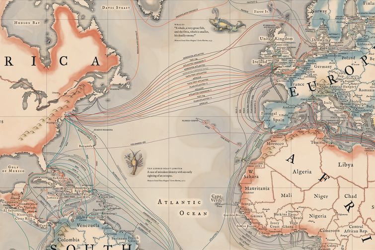
Map of the undersea cables that connect the internet
page: 110
share:
A link to a well put together OP on a FreeRepublic thread about the undersea cables that connect the internet. Quite an interesting map. (mods, I
don't know if we should link to posts on another site, if not please deep-six this thread, thanks).
www.freerepublic.com...
I'll grab and post the illustration. Look how the cables between Europe and North America almost all go to or near the same land areas:
www.freerepublic.com...
I'll grab and post the illustration. Look how the cables between Europe and North America almost all go to or near the same land areas:
edit on 15-3-2015 by Aleister because: (no reason given)
nice map!
btw has the case of the cut cables (mediterranean sea i guess) ever been solved? don't know what machine or lifeform did it but considering the agglomeration it would be easy for a vile character to cause a lot of chaos in a short period of time.
btw has the case of the cut cables (mediterranean sea i guess) ever been solved? don't know what machine or lifeform did it but considering the agglomeration it would be easy for a vile character to cause a lot of chaos in a short period of time.
a reply to: anticitizen
Don't know much about the case personally, but with all of these cables traveling roughly to the same neck of the woods (both in Europe and America) hopefully they are well protected and observed.
Don't know much about the case personally, but with all of these cables traveling roughly to the same neck of the woods (both in Europe and America) hopefully they are well protected and observed.
They left Israel off the map and put in Palestine instead.
Cue conspiracy music.
Cue conspiracy music.
a reply to: Aleister These cable represent all the "known" cables. I bet there are secret ones on the sea floor, that have to
do with military, or some other agency. It reminds me of the cables that are layed out on the seafloor the Navy uses to help track subs around the
world.
originally posted by: AugustusMasonicus
They left Israel off the map and put in Palestine instead.
Cue conspiracy music.
From the looks of it it's an old map (at least the map part, not the cable part), probably used before 1947. And from the looks of it you are well ready for St. Patties Day, aye!
originally posted by: Ceeker63
a reply to: Aleister These cable represent all the "known" cables. I bet there are secret ones on the sea floor, that have to do with military, or some other agency. It reminds me of the cables that are layed out on the seafloor the Navy uses to help track subs around the world.
Iz wouldn't bet against you on this one. Military cables probably wouldn't be on any public maps, not only 'secret' European and U.S. cables, but a swarm of them. Probably Google itself has secret cables running hither and yon and right up....to my....computer (runs, not walks, to get ready for St. Pats Day).
a reply to: Aleister
Sorta, but not really. They updated all of Africa; changing Abyssinia to Ethiopia and Somalia and splitting Algeria into its contemporary counterparts.
Yup, already had my corned beef last night at the lodge and made hash for breakfast. About the only time of year I eat that.
Sorta, but not really. They updated all of Africa; changing Abyssinia to Ethiopia and Somalia and splitting Algeria into its contemporary counterparts.
Yup, already had my corned beef last night at the lodge and made hash for breakfast. About the only time of year I eat that.
edit on 15-3-2015 by AugustusMasonicus because: networkdude has no beer
a reply to: AugustusMasonicus
So it's a newer map, with Israel forgotten. Israel won't be ignored (as they've proven again and again)! Maybe I'll find a good Irish avatar for a couple of days, or maybe Lefty Grove was Irish (must research star pitcher's ancestry).
EDIT: Grove's ole ma's name was Emma Catherine Beeman, a fine Irish moniker, aye.
edit on 15-3-2015 by Aleister because: (no reason given)
a reply to: Aleister
The darker grey sea area's.. seem to represent the coastline before the great water rise.
Even Atlantis is just behind the pillars of Hercules, and the cable go nice around it... Just in case of a water drop.
The darker grey sea area's.. seem to represent the coastline before the great water rise.
Even Atlantis is just behind the pillars of Hercules, and the cable go nice around it... Just in case of a water drop.
edit on 15-3-2015 by
EartOccupant because: (no reason given)
a reply to: Aleister
Leave it to you, sir, to be interesting... thanks! I am ignoring my livelihood to peruse this thread...so you are responsible, in part, for my impending unemployment... so thanks again!
Now I'd like a map of all the alphabet agencies' little devices sunk to hack into the communiques'... but that's SO last century... now they can suck it all outta the "clouds."
... I miss the days we didn't know about ubiquitous spying and we could say any fool thing we wanted without thought of consequences...
FIRE! FIRE! Heh...
edit on 3/17/2015 by Baddogma because: lost an "it" somewhere...
edit on 3/17/2015 by Baddogma because: and an
apostrophe
Huh, we have FOUR cables coming into my city and I'm still paying more than $60 for a 10 meg connection. We only have two ISPs. One cable, one DSL.
How can our internet in Alaska suck so badly with four fiber cables?
How can our internet in Alaska suck so badly with four fiber cables?
I wonder if they have cable like this set in place to detect incoming Subs ?
Also i wonder if this has any Effect on Whale navigation Or any other sea creature that navigates using its sens's .
My mind is just wondering .....
Also i wonder if this has any Effect on Whale navigation Or any other sea creature that navigates using its sens's .
My mind is just wondering .....
a reply to: Baddogma
Unemployment is all it's cracked up to be. Yes, the cables are probably tapped into like a tap dancer on a sugar rush, but they would be in any case. I actually was a bit surprised so much travels by cable and not by satellite, although that shows my computer illiterate knowledge base. If I were a fish I'd make my breeding ground among the cables, and think of the romantic notes being passed back and forth over them.
Unemployment is all it's cracked up to be. Yes, the cables are probably tapped into like a tap dancer on a sugar rush, but they would be in any case. I actually was a bit surprised so much travels by cable and not by satellite, although that shows my computer illiterate knowledge base. If I were a fish I'd make my breeding ground among the cables, and think of the romantic notes being passed back and forth over them.
OK, I just talked with a friend who knows his IT stuff, and he said that the map is WRONG in regards to the cables going to Alaska. There are only two
connections to Juneau, not three. There's Alaska United East and Northstar...so not sure why it's showing three.
a reply to: GetHyped
I was told a long time ago that there is a network of undersea microphones to detect submarines.
Edit: Here you go...
I was told a long time ago that there is a network of undersea microphones to detect submarines.
Edit: Here you go...
edit on 17-3-2015 by MystikMushroom because: (no reason given)
somewhere down there is the First trans Atlantic cable from the late 1800's for the Telegraph and then for the Telephone.
the History is on this website :
atlantic-cable.com...
the History is on this website :
atlantic-cable.com...
edit on 17-3-2015 by bobw927 because: misspelled a word
new topics
-
Cats Used as Live Bait to Train Ferocious Pitbulls in Illegal NYC Dogfighting
Social Issues and Civil Unrest: 40 minutes ago -
The Good News According to Jesus - Episode 1
Religion, Faith, And Theology: 2 hours ago -
HORRIBLE !! Russian Soldier Drinking Own Urine To Survive In Battle
World War Three: 4 hours ago -
Bobiverse
Fantasy & Science Fiction: 7 hours ago -
Florida man's trip overseas ends in shock over $143,000 T-Mobile phone bill
Social Issues and Civil Unrest: 7 hours ago -
Former Labour minister Frank Field dies aged 81
People: 9 hours ago -
SETI chief says US has no evidence for alien technology. 'And we never have'
Aliens and UFOs: 11 hours ago
top topics
-
President BIDEN Vows to Make Americans Pay More Federal Taxes in 2025 - Political Suicide.
2024 Elections: 16 hours ago, 19 flags -
Florida man's trip overseas ends in shock over $143,000 T-Mobile phone bill
Social Issues and Civil Unrest: 7 hours ago, 8 flags -
SETI chief says US has no evidence for alien technology. 'And we never have'
Aliens and UFOs: 11 hours ago, 7 flags -
Former Labour minister Frank Field dies aged 81
People: 9 hours ago, 4 flags -
Bobiverse
Fantasy & Science Fiction: 7 hours ago, 3 flags -
Ode to Artemis
General Chit Chat: 17 hours ago, 3 flags -
This is our Story
General Entertainment: 14 hours ago, 3 flags -
Cats Used as Live Bait to Train Ferocious Pitbulls in Illegal NYC Dogfighting
Social Issues and Civil Unrest: 40 minutes ago, 3 flags -
HORRIBLE !! Russian Soldier Drinking Own Urine To Survive In Battle
World War Three: 4 hours ago, 2 flags -
The Good News According to Jesus - Episode 1
Religion, Faith, And Theology: 2 hours ago, 0 flags
active topics
-
HORRIBLE !! Russian Soldier Drinking Own Urine To Survive In Battle
World War Three • 19 • : KnowItAllKnowNothin -
Florida man's trip overseas ends in shock over $143,000 T-Mobile phone bill
Social Issues and Civil Unrest • 14 • : Raptured -
DerBeobachter - Electric Boogaloo 2
Introductions • 14 • : ElitePlebeian2 -
LaBTop is back at last.
Introductions • 16 • : ElitePlebeian2 -
VirginOfGrand says hello
Introductions • 4 • : ElitePlebeian2 -
TLDR post about ATS and why I love it and hope we all stay together somewhere
General Chit Chat • 9 • : ElitePlebeian2 -
SETI chief says US has no evidence for alien technology. 'And we never have'
Aliens and UFOs • 32 • : bhtaylor53 -
Breaking Baltimore, ship brings down bridge, mass casualties
Other Current Events • 480 • : IndieA -
President BIDEN Vows to Make Americans Pay More Federal Taxes in 2025 - Political Suicide.
2024 Elections • 87 • : FlyersFan -
Thousands Of Young Ukrainian Men Trying To Flee The Country To Avoid Conscription And The War
Other Current Events • 134 • : Consvoli
10