It looks like you're using an Ad Blocker.
Please white-list or disable AboveTopSecret.com in your ad-blocking tool.
Thank you.
Some features of ATS will be disabled while you continue to use an ad-blocker.

Volcano Watch 2015-2021
page: 4share:
a reply to: lurksoften
Source
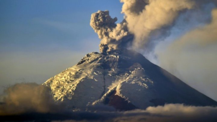
Ecuador volcano spews giant ash column
QUITO (AFP) - Ecuador's Cotopaxi volcano, which began erupting in August after being dormant for 138 years, on Thursday coughed up a two-kilometer-high column of ash, officials said.
The giant ash column was visible from Quito, 45 kilometers (30 miles) to the north of the volcano, considered one of the world's most dangerous because its snow cap is vulnerable in an eruption and because of its close proximity to densely populated areas.
Ecuador's security coordination ministry said ash rose 2,000 meters above the volcano's crater, and warned some could fall on Quito's southern neighborhoods.
Cotopaxi, one of eight active volcanoes in Ecuador, last erupted in 1877.
The government declared a state of emergency in August after the volcano roared to life and has been conducting evacuation drills among the population.
An estimated 325,000 people could be affected if the eruption triggers mudslides and avalanches, according to the authorities.
Source
edit on 8-10-2015 by lurksoften because: totally forgot to add source
Not sure if i missed the discussion on this one.
Source
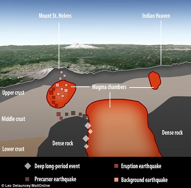
Mount St. Helens study confirms three more magma chambers
Scientists release findings of latest research into plumbing below volcano
LONGVIEW — Scientists have released the first results of a pioneering, $3 million study of the plumbing below Mount St. Helens, and they shed light on how the volcano may have erupted in 1980.
The study has found three more magma chambers, or reservoirs, below and east of the peak. Scientists before had only been able to confirm one immediately below the crater, though they had suspected the existence of the others.
The findings, released Tuesday, show the volcano’s plumbing system is far more complex than geologists thought and that the molten rock that fueled the 1980 explosion may have come from much deeper underground. And it didn’t have a straight path to the surface.
Instead, as earthquakes cracked solid rocks, the magma may have twisted and turned between three different pools of magma.
So far, researchers think they’ve identified four magma chambers in the vicinity of the summit: the previously known small chamber right beneath the crater; two chambers 3 to 8 miles below sea level; and one larger chamber 9 to 25 miles below sea level that extends as far east as the Indian Heaven Wilderness. Researchers said there’s still no evidence yet that the big pool of molten rock fuels other volcanoes, such as Mount Adams or Mount Rainier.
Three of the chambers appear to be connected, though, because earthquakes that occurred before and during the 1980 eruption moved up along the edge of the biggest magma chamber and into the upper chamber below the mountain, Rice University geophysicist Alan Levander said. This understanding could help scientists better track rising magma the next time the volcano acts up.
Source
This one has been going on and off since july.
Source
Mexico: Colima volcano has another double eruption
Less than a week after a pair of eruptions, Mexicos Colima or Fire volcano pulled of the feat again on Tuesday (10 November) morning, as its period of activity continues.
According to officials, the first eruption occurred at 7.03am local time, sending a column of ash and smoke some 2,500m into the sky. National Civil Protection coordinator Luis Felipe Puente said on his Twitter account that ash and smoke rose 2,000m above the crater of the volcano during the second explosion, which occurred at 9.02am local time.
Located in the south-western Mexican state of Colima, the Fire Volcano has been exhibiting continuous activity since 9 July. Over the past months, nearby villages have been blanketed with thick coats of ash, prompting evacuations.
Source
a reply to: lurksoften
That was an interesting read!
Thanks!
It makes me wonder if they have looked much at what is under Mt Rainier...
Sure doesn't sound like it.
That was an interesting read!
Thanks!
It makes me wonder if they have looked much at what is under Mt Rainier...
Researchers said there’s still no evidence yet that the big pool of molten rock fuels other volcanoes, such as Mount Adams or Mount Rainier.
Sure doesn't sound like it.
www.wired.com...
Pretty awesome sight! Looks like it is rumbling back to life.
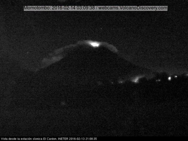
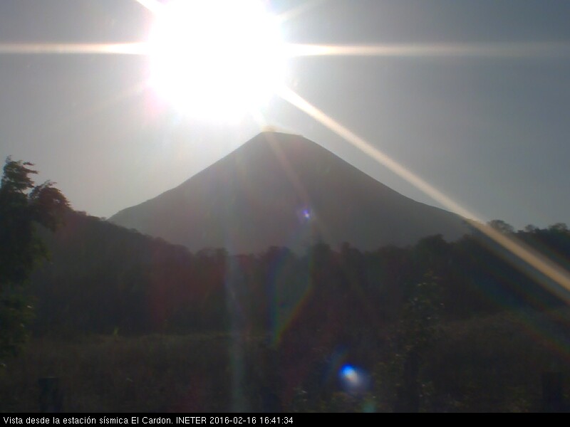
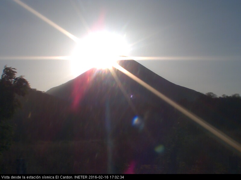
Last night Nicaragua’s Momotombo started its first eruption since 1905. The vigorous Strombolian eruption (see above and below) produced an impressive lava fountain along with a dark ash plume over the area near Lake Managua. Local reports suggest that people started feeling tremors and noticing steam plumes from Momotombo over the past few weeks. Then, late on Monday night, a new eruption began, sending incandescent volcanic debris cascading down the slopes of the volcano. By morning, the activity had waned, though a strong steam plume can still be spotted coming from the volcano on the INETER webcam pointed at Momotombo. At least six communities around Momotombo reported ash fall and as a precaution, schools in the region have been closed.
Pretty awesome sight! Looks like it is rumbling back to life.
Up until 1905, Momotombo was one of Nicaragua’s most active volcanoes. Between 1849-1905, the volcano produced 10 eruptions and in 1605, Momotombo had a major eruption that destroyed the then-capital of the region, Leon Viejo. This has been a noisy week for volcanoes in Central America. Fuego and Santiaguito in Guatemala both had moderate eruptions, with Fuego’s in particular producing an impressive lava fountain. Meanwhile, a small ash plume was spotted earlier in November from Telica, one of Nicaragua’s other active volcanoes, as part of its restless 2015. None of these volcanoes are connected in any way beyond the fact that they lie in the same tectonic setting, where the Cocos Plate is subducting beneath the Caribbean Plate.
a reply to: diggindirt
I was watching the earthquakes at Momtombo months ago and got impatient. I knew it was going to blow.
Whenever I think about geology, I don't realize half the time it's slow. Time is weird. Let's not talk the other time, let's talk geological time. The way the earth seems to work is like me. Manic, bi polar. Long periods, of sometimes boring banality, and then, and then, the dam bursts, the fault snaps, the lightning strikes, the wind shifts, the magma pulses- whichever, whenever. Convulsions. Contractions. Sharp, sharp, pains.
Thank god, the long boring stuff in between is usually peaceful and pastoral. Without a doubt, without a doubt, I think we're nearing the end of a long warm dream. In the case, a cool dream by a stream. Now, the wind #s.
Funny thing, the other night I watch something about Panama. I fell asleep. But it started with a bit about the geology and how it dammed up the gap between Atlantic and Pacific. Cool stuff. Look it up.
57 micro tremors at Akan volcano, Hokkaido, Japan
Bing interactive map
more info on the volcano
volcano.si.edu...
Just mentioned it because the daily micro quakes went over 200 for the 31st Dec 2015, when this happens I have to adjust the pie chart which only goes up to 200 and its a PITA,
so I had a look to see where these extra micros were coming from
no volcano alert from JMA
a reply to: muzzy
TESHIKAGA REGION
@ 02/01/2016 22:59:09 JST, now
mag~1= 130
mag1= 2
new map
*only showing 124
due to changed link address for 2016
I was just filing the data for that away in 2016 and noticed one I had forgotten from this area
a 91 event series of aftershocks over 3 days from a 5.0 on 4/06/2015 4:34 further NE above Lake Akan.
June Akan map
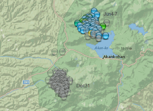
I've got 192 events above M1 recorded for TESHIKAGA REGION in 2015
and 139 below M1, but I only started saving below M1 after 10/08/2015
TESHIKAGA REGION
@ 02/01/2016 22:59:09 JST, now
mag~1= 130
mag1= 2
new map
*only showing 124
due to changed link address for 2016
edit on 010000002216 by muzzy because: (no reason given)
I was just filing the data for that away in 2016 and noticed one I had forgotten from this area
a 91 event series of aftershocks over 3 days from a 5.0 on 4/06/2015 4:34 further NE above Lake Akan.
June Akan map
edit on 010000002216 by muzzy because: (no reason given)
edit on 010000002216 by muzzy because: (no reason given)
I've got 192 events above M1 recorded for TESHIKAGA REGION in 2015
and 139 below M1, but I only started saving below M1 after 10/08/2015
edit on 010000002216 by muzzy because: (no reason given)
Hello everyone and whom ever edited the title of the thread to include 2016, a huge thank you, i had completely forgotten all about this...
anyway its been a while since anyone has updated this thread and there are currently three newly active volcanoes either going to erupt or are already beginning to erupt and here are their sources ... i started following volcano updates on my twitter account two days ago.
two major volcanoes in Mexico are erupting at this moment ...
links here with photos ..
fears that Mount Vesuvius in Italy is waking up. she never erupts quietly either..
www.christiantoday.com...
( dont put too much faith in the source. i got it through my twitter feed)
from the daily mail online
www.dailymail.co.uk... ns-Mount-Vesuvius.html
im going to check ccn etc for better confirmation .. cheers and a very happy new year
apparently these sources are correct. at least with mexico
i found this site which has a map with the current erupting volcanoes around the world
enjoy
anyway its been a while since anyone has updated this thread and there are currently three newly active volcanoes either going to erupt or are already beginning to erupt and here are their sources ... i started following volcano updates on my twitter account two days ago.
two major volcanoes in Mexico are erupting at this moment ...
links here with photos ..
newsfirst.lk...
Two of Mexico’s volcanoes rumbled to life on Saturday (January 23), spewing large plumes of ash and smoke high into the sky.
fears that Mount Vesuvius in Italy is waking up. she never erupts quietly either..
www.christiantoday.com...
( dont put too much faith in the source. i got it through my twitter feed)
from the daily mail online
www.dailymail.co.uk... ns-Mount-Vesuvius.html
im going to check ccn etc for better confirmation .. cheers and a very happy new year
apparently these sources are correct. at least with mexico
i found this site which has a map with the current erupting volcanoes around the world
enjoy
www.volcanodiscovery.com...
edit on amMonday163902am.am12 by alysha.angel because: (no reason
given)
Jeez, Could this be just bad timing or what?
www.zerohedge.com...
What were they thinking when they built this place. Just like Fuki, bad place for a Nuc plant.
www.zerohedge.com...
What were they thinking when they built this place. Just like Fuki, bad place for a Nuc plant.
follow up to: muzzy
I noticed an increase in micro events at Akan over the last week and decided to update the whole thing from the start.
here is the new map and a graph
here's the graph itself. rightclickviewimageforfullsize
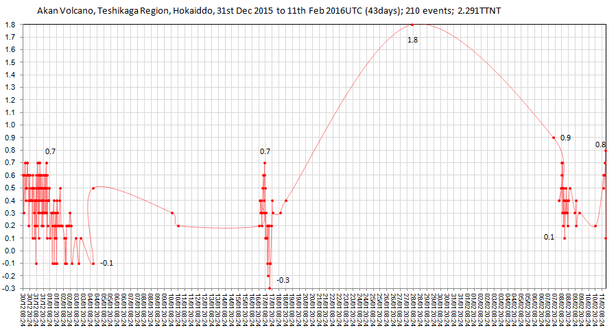
If you read japanearthquakes regularly, particularly the timeline graphs on the featured event pages, you will notice how this graph differs from a short swarm or a large shock and aftershock series.
No Volcanic Warnings are currently in effect.
I haven't done volcano's on japanearthquakes before, but seeing as Google dumped the interactive mapping Classic Maps I need to find a new location for these. 2015 Hakone is a work in progress, 2733 earthquake events over 5 months.
I noticed an increase in micro events at Akan over the last week and decided to update the whole thing from the start.
here is the new map and a graph
here's the graph itself. rightclickviewimageforfullsize
If you read japanearthquakes regularly, particularly the timeline graphs on the featured event pages, you will notice how this graph differs from a short swarm or a large shock and aftershock series.
No Volcanic Warnings are currently in effect.
Meakandake is an andecitic composite volcano group formed at the SW crater wall of the Akan caldera, located at the eastern part of Hokkaido. Nakamachineshiri crater, located at the center of the group, and Ponmachineshiri crater, located at the summit, have vigorous sulfuric activities and there are many sulfuric fumaroles and hot springs at the flank and the foot of the volcano. www.data.jma.go.jp...
edit on 02000000424216 by muzzy because: (no reason given)
I haven't done volcano's on japanearthquakes before, but seeing as Google dumped the interactive mapping Classic Maps I need to find a new location for these. 2015 Hakone is a work in progress, 2733 earthquake events over 5 months.
edit on 02000000424216 by muzzy because: (no reason
given)
MOMBOTOMBO is erupting again. Two earthquakes offshore are maybe related. I wish I had more time and such, and I could put up links and pictures and a
video and such. Heck maybe I got a few minutes. Hold on for video...
I wouldn't let me upload whole video. I caught a snapshot and you can see it glowing. There's news on Volcano Discovery.
I found a video on you tube...
www.youtube.com...
I wouldn't let me upload whole video. I caught a snapshot and you can see it glowing. There's news on Volcano Discovery.
I found a video on you tube...
www.youtube.com...
edit on 14-2-2016 by ericblair4891 because: (no reason given)
I've been trying to tell myself that Mombotombo won't erupt that much. It's not blocked up and building pressure. Even the two explosive periods came
months apart and the explosions were on the mediocre side of massive. I keep wanting to step back from watching Nicaragua, but can't. I was joking
around about the name with my son. And, I told him that if I was to travel to see a volcano, we should go to Nicaragua so we could toboggan down Cerro
Negro. I think this would be a good place to go. To ensure that I was to see a volcano erupting on our trip, I think it would be best to travel right
from Mexico and hit Colima and Popo, then carry on to Fuego and others before ending up at Cerro Negro. I'm sure one of them would be active.
Which takes me back to my point. Yesterday, I was going to say that there are earthquakes around Nicaragua, and I think they are related to Mombotombo. But, they weren't that big, and there weren't that many. Just a small bunch. Hmmm . so what???
Today, I had a little more time and looked at Volcano Discovery's website. The curious thing is that they seemed to be obsessed with Nicaragua as well. Because, many of their stories are about neigbouring volcanoes.
Mombotombo erupting
Masaya lava lake expanding and lots of activity.
Cerro Negro is restless...
Telica " Nicaragua's volcanoes remain in a particularly active state. A series of approx. 12 small explosions occurred at Telica volcano on Saturday morning, the Nicaraguan Institute of Territorial Studies INETER reported. Ash columns from the eruptions rose from 300 to 1000 meters above the crater."
Here's their website...
www.volcanodiscovery.com...
I haven't checked- I know they give tours of volcanoes, maybe the travel group is currently in Central America. HA. I'm sure I should look.
I've been watching for a long time now. I really wish I was always wrong. I'm watching because this is where I think it's starting. I'm a follower of the conservation of energy. Equal and opposite and all that stuff. If we think of the ring of fire as a circle- it isn't - then we've had some massive earthquake around it in the last decade or so. Let's start where the worst and first big one hit. BAnda Aceh. And when I locate these big ones, I'll reference them as if they are on a clock. So, Banda Aceh was 9 o'clock. 9.1 M In fact, to add, there's few 8 + around 9 o'clock.
Then we have Chile at 5 o'clock. 8.8M Japan 9 M would be around 10 o'clock. We've had Alaska chiming in around 8 M at 12 o'clock.
There is a big gap. From 1 o'clock all the way down to 5 o'clock are quiet. There is also a gap from 5 o'clock until 9 o'clock. However, if you look at a map with all the magnitude 8 since 1900, then that portion of the clock is filled. There are constant earthquakes in that zone. But if you look at the map, you'll see the big gap again. North America sits there looking odd. Where's the beef?
This is my point. It's a ring of fire. There's giant cracks that haven't been as active as the other parts of the circle. Is that Normal? Has it always been this way. Obviously not. Slow earthquakes and periodic smaller and constant earthquakes can alleviate stress, however, it can't explain the lack of big ones.
So, I believe, that all that energy, which has been mostly been moving around Sumatra and Japan in east, will eventually have the same energy manifest itself in the west.
So, why am looking at the middle. Central America. Well, it's a string. It's like the connections in the brain. Synapses in the brain can break. Heck, puberty is suppose to prune them. Central America is a thin strip that connects two big continents. At one point, Central didn't exist as land and the two oceans met. If the Pacific is push against the Americas, volcano may precede any major thrust.
ahh what do i know....
i'm just watchin'
is all
edit on 16-2-2016 by ericblair4891 because: (no reason given)
I'm glad Volcano Discovery has updated their news and "they" are the ones saying Nicaragua is having some really rumblings. As I have already stated,
something is up. I really want to go on and on and say that they are all connected. However, these are all young, active volcanoes. There is really no
surprise when any of them erupt. That's what volcanoes do. It's just that I'm a firm believer in clustering. Clusters are not necessarily
coincidental, but they sure pop up a lot when something big goes down. And, it's usually a larger unifying force that is behind the curtains, pulling
all the levers, Mr. Grand Wizard, of Land of Oz.
Honestly, between you and me, I think the plate is diving down. The pressure it's creating is pushing upward. I'm not sure what's next. I was thinking more northerly along ring. But first, we may have a massive earthquake in Central America first. When I was looking at a list of top earthquakes since 1900, there was a doozy there. I'll check.....
I'm wrong, It was off of Ecuador. The top part of South America. The gap of lack of really big ones starts where Central America begins. The records shows many in the 7.5+ range, but nothing like 8.8M and upward. Gosh, I just checked the listing for Chile and 8M are common. If something like Japan or Banda Aceh were occur on the coast, Central America seems so thin, it almost seems like it'd be swept off the map. I exaggerate, but image Japan happening off Nicaragua.
The people are completely unprepared. It would be more like Banda Aceh. Total destruction. These countries are poor, and have many problems. I don't think Nicaragua is as bad as a couple others in the neighbourhood, but they are not prepare none-the-less.
Oh, I almost forgot, read the guys for Volcano Discovery, they're the ones who said there was something up...
www.volcanodiscovery.com...
I was hoping to catch the time limit and not open a new thingy. Oh well.
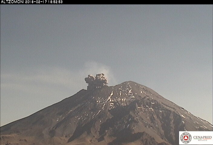
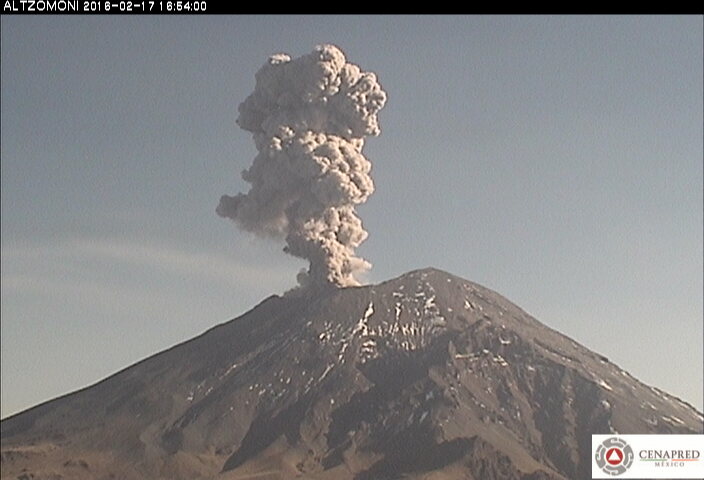
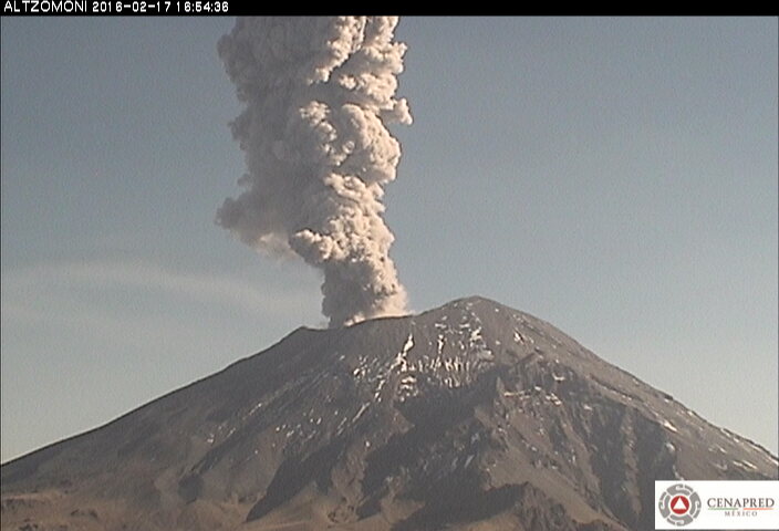
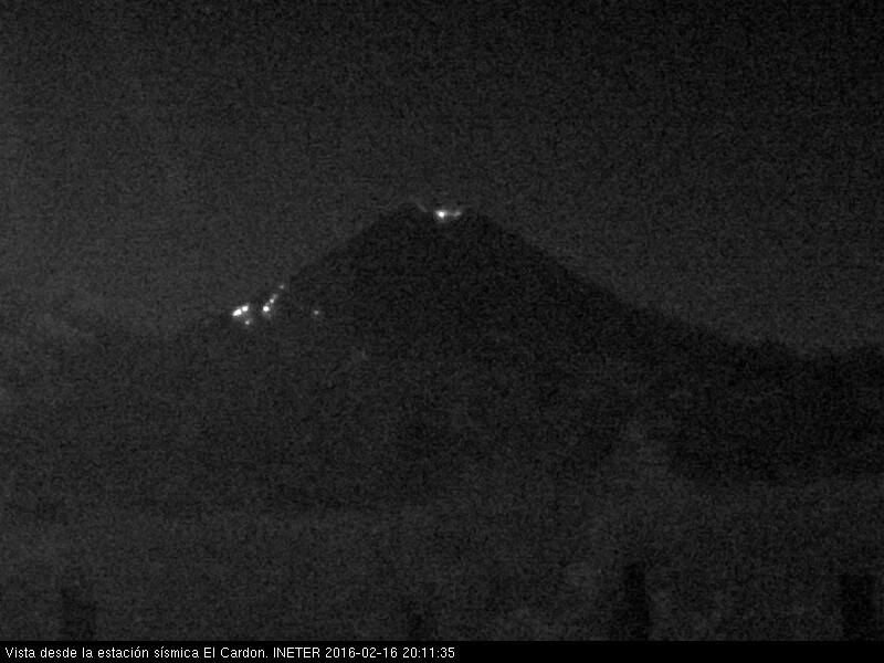
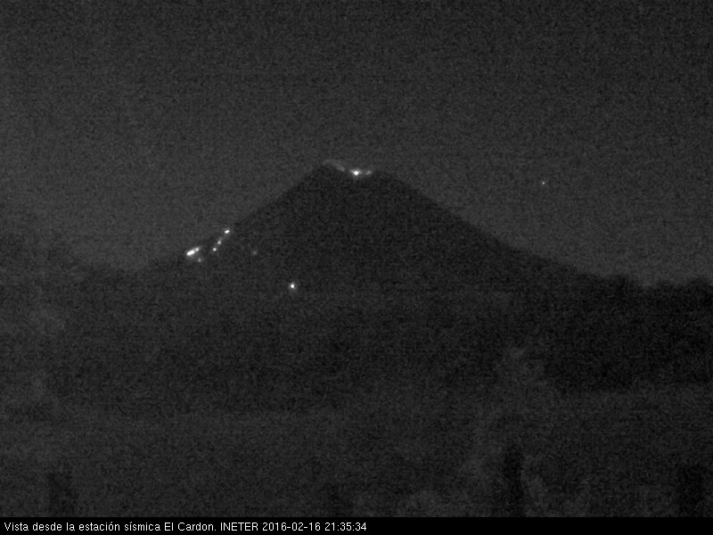
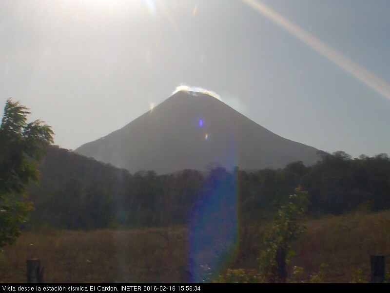
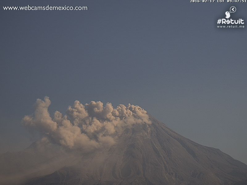
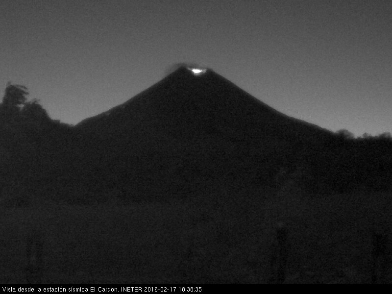
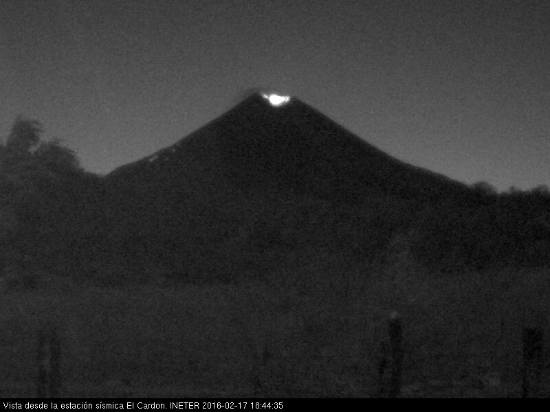
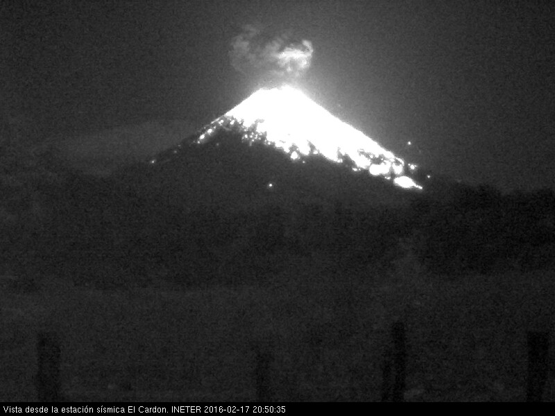
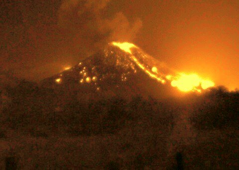
I caught Popo erupting. It shouldn't be that exciting, because it resembled any common eruption at Colima. Colima has been erupting all day but it's dirty. The camera is so cloudy and dark it's spooky. I'm going to post a whole truck load of images. The first bunch are POPO. Then I'll post some shots of Mombotombo. There was some lava bombs, the size of cars and such- one set off a bush fire. You can see them glowing at night. In fact, I couldn't explain what I was seeing during the day. I thought there was another vent opening up. But no, it's just the volcano throwing bombs. It's not doing much at the moment, but it's obviously full of lava, and glowing and smoking during the day.
Um. The shots that are randomish. We'll that's UFO's checking out the volcano. I think. You know, what, that guy Hubburd or something like that, the science fiction "scientist" guy. ha. We'll anywho, my twelve year old son said they were lens flares. What? No one was shooting off flares. What evar. I insisted they were UFOs landing on the volcano.
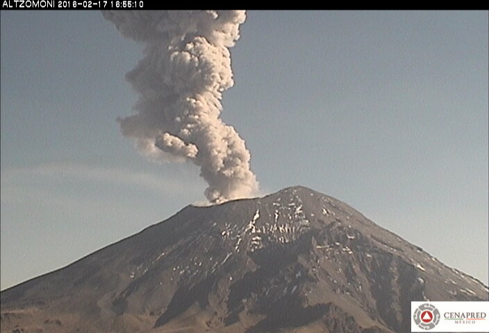
The last one is dirty Colima. I was watching POPO because I serious thought it was going to pop out a smoke ring. Don't laugh. Etna has done it several times and people have caught it on film. You can search it.
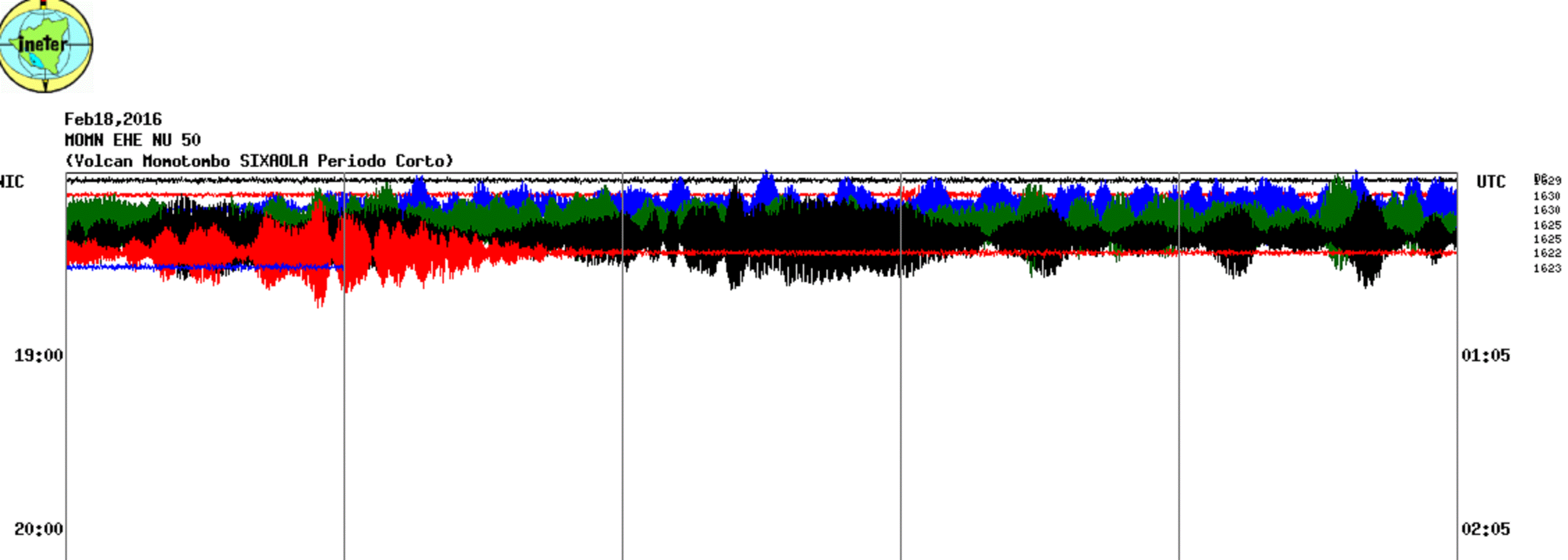
Oh, I caught some harmonic tremor for ya. I'm sure it's that because it's showing up on a bunch of graphs. Oh, I mean Mombotombo. The webcam doesn't show any erupting material at the moment. There's cloud on top. I'll post image in a bit when there's more on that page- it just started a new time period on a new page.... ten minutes or so. it's cool, i noticed it earlier, and thought it was just noise.
Ah, it stopped for the moment. But I bet there's big burst soon. The clouds thinned enough so you can see there's lava right at the top and it's glowing.
I caught Popo erupting. It shouldn't be that exciting, because it resembled any common eruption at Colima. Colima has been erupting all day but it's dirty. The camera is so cloudy and dark it's spooky. I'm going to post a whole truck load of images. The first bunch are POPO. Then I'll post some shots of Mombotombo. There was some lava bombs, the size of cars and such- one set off a bush fire. You can see them glowing at night. In fact, I couldn't explain what I was seeing during the day. I thought there was another vent opening up. But no, it's just the volcano throwing bombs. It's not doing much at the moment, but it's obviously full of lava, and glowing and smoking during the day.
Um. The shots that are randomish. We'll that's UFO's checking out the volcano. I think. You know, what, that guy Hubburd or something like that, the science fiction "scientist" guy. ha. We'll anywho, my twelve year old son said they were lens flares. What? No one was shooting off flares. What evar. I insisted they were UFOs landing on the volcano.
The last one is dirty Colima. I was watching POPO because I serious thought it was going to pop out a smoke ring. Don't laugh. Etna has done it several times and people have caught it on film. You can search it.
Oh, I caught some harmonic tremor for ya. I'm sure it's that because it's showing up on a bunch of graphs. Oh, I mean Mombotombo. The webcam doesn't show any erupting material at the moment. There's cloud on top. I'll post image in a bit when there's more on that page- it just started a new time period on a new page.... ten minutes or so. it's cool, i noticed it earlier, and thought it was just noise.
Ah, it stopped for the moment. But I bet there's big burst soon. The clouds thinned enough so you can see there's lava right at the top and it's glowing.
edit on 17-2-2016 by ericblair4891 because: (no reason given)
Yeah, baby. Look at the shot I caught. Almost missed it. Volcano Discovery will have the video of the stop frame soon.
Nice screen Shots.
If you look at CERI, It seems the whole North American Plate is vibrating.
folkworm.ceri.memphis.edu...
If you look at CERI, It seems the whole North American Plate is vibrating.
folkworm.ceri.memphis.edu...
Unfortunately, Volcano Discovery`s webcam archives somehow missed the eruption. I looked at it a few times and the frames with the big stuff aren't
there. So, I did a news search and there's some articles. First I'll post a you tube link with a video of the webcams and it's got the main shots. Now
I'm upset the camera only takes a photo every five minutes. They have three cameras. One, you can barely see the mountain because it's so far away.
Number two camera doesn't get any night shots. Not sure why. So, there's just one cam that captures the shots. This is a good thing, because when I
started watching they only had the distant camera that doesn't really work.
Today, the mountain is just smokey and steamy. No, tremors. Settled down. Oh, there's a woodpecker on a tree outside my window. Distracted. Pope is smoking as well and it looks very volcanoey on all the cameras. Popo has at least half a dozen cameras. I like the one with a ferris wheel in the foreground.
www.youtube.com...
Here's some articles, all in Spanish, so you'll have to translate.
www.laprensa.com.ni...
www.tn8.tv...
Oh, and one of the articles the local felt an earthquake at Maysa. Nicaragua is still rumbling.
I spelled Maysa wrong. This next article has the USGS geologists and volcanologists showing up in Nicaragua to do a risk assessment and update the government. Wow, good timing. They're there today. Right in the thick of the action. You'd think they knew something was up.....
www.elnuevodiario.com.ni...
"Experts from the US Geological Survey (USGS) today recommended develop and design maps about the dangers of Masaya and Momotombo volcanoes in the Pacific of Nicaragua, in order to reduce risks to nearby populations.
"A hazard map is important. They will teach what are the least dangerous and most dangerous areas are," he told reporters USGS expert, who is studying volcanoes in Nicaragua, Christopher Harpel.
Although Nicaragua has risk maps in the Masaya volcano, southeast of Managua, the hazard maps are more specific because they are more accurate and includes minor hazards, they explained the experts of the USGS.
Interested: USGS more specialists will arrive to study volcanoes in Nicaragua
"There are several scenarios of what can happen in a volcano, there are chances, but we also have to think about it less likely," he said, meanwhile, the American specialist Heather Wright.
Scientists today toured the Masaya Volcano, 23 kilometers southeast of Managua, a day after inspecting the Momotombo volcano.
Among the aspects analyzed to project future scenarios of both volcanoes , are the monitoring data, the history of each volcanic structure and overview.
Both Masaya as Momotombo are in eruptive phases since December, that do not involve danger to their populations.
The Momotombo volcano, 1,297 meters high, increased its activity in December, after 110 years of relative calm.
The Momotombo, located in the "line of fire" of the Pacific and in the "chain of volcanoes", is located at the northern end of Lake Managua or Xolotlán."
I told you I spelled it wrong. It's Masaya.
Do you want to see the craziest video ever? Telica has a camera too. It's right at the top of the volcano with a close view of the caldera. Also, it seems that you can walk right up to the top and look inside. I told you this was the best country to check out a volcano. Well, region by large, it could be a slow day. But not this day in the video. just watch...
www.youtube.com...
Oh, it's erupting again. Saw and earthquake as well, not sure where though. Here's link for MOMBOTOMBO webcam...
www.youtube.com...
The neat part about watching is that the volcano is starting brush fires. Since the volcano was sleeping for near a hundred years, a rough brush grew on the slopes of the volcano. Now, it's hurling lava bombs and they are setting wildfires. You can see a fire in this shot...
edit on 18-2-2016 by ericblair4891 because: (no reason given)
new topics
-
Sunak spinning the sickness figures
Other Current Events: 37 minutes ago -
Nearly 70% Of Americans Want Talks To End War In Ukraine
Political Issues: 48 minutes ago -
Late Night with the Devil - a really good unusual modern horror film.
Movies: 2 hours ago -
Cats Used as Live Bait to Train Ferocious Pitbulls in Illegal NYC Dogfighting
Social Issues and Civil Unrest: 3 hours ago -
The Good News According to Jesus - Episode 1
Religion, Faith, And Theology: 5 hours ago -
HORRIBLE !! Russian Soldier Drinking Own Urine To Survive In Battle
World War Three: 8 hours ago -
Bobiverse
Fantasy & Science Fiction: 10 hours ago -
Florida man's trip overseas ends in shock over $143,000 T-Mobile phone bill
Social Issues and Civil Unrest: 10 hours ago
top topics
-
Florida man's trip overseas ends in shock over $143,000 T-Mobile phone bill
Social Issues and Civil Unrest: 10 hours ago, 8 flags -
SETI chief says US has no evidence for alien technology. 'And we never have'
Aliens and UFOs: 14 hours ago, 7 flags -
Cats Used as Live Bait to Train Ferocious Pitbulls in Illegal NYC Dogfighting
Social Issues and Civil Unrest: 3 hours ago, 7 flags -
This is our Story
General Entertainment: 17 hours ago, 4 flags -
Former Labour minister Frank Field dies aged 81
People: 13 hours ago, 4 flags -
Bobiverse
Fantasy & Science Fiction: 10 hours ago, 3 flags -
Late Night with the Devil - a really good unusual modern horror film.
Movies: 2 hours ago, 2 flags -
HORRIBLE !! Russian Soldier Drinking Own Urine To Survive In Battle
World War Three: 8 hours ago, 2 flags -
The Good News According to Jesus - Episode 1
Religion, Faith, And Theology: 5 hours ago, 0 flags -
Nearly 70% Of Americans Want Talks To End War In Ukraine
Political Issues: 48 minutes ago, 0 flags
active topics
-
Nearly 70% Of Americans Want Talks To End War In Ukraine
Political Issues • 4 • : budzprime69 -
President BIDEN Vows to Make Americans Pay More Federal Taxes in 2025 - Political Suicide.
2024 Elections • 114 • : ImagoDei -
HORRIBLE !! Russian Soldier Drinking Own Urine To Survive In Battle
World War Three • 24 • : budzprime69 -
Breaking Baltimore, ship brings down bridge, mass casualties
Other Current Events • 482 • : IndieA -
How ageing is" immune deficiency"
Medical Issues & Conspiracies • 30 • : annonentity -
Remember These Attacks When President Trump 2.0 Retribution-Justice Commences.
2024 Elections • 55 • : Zanti Misfit -
SETI chief says US has no evidence for alien technology. 'And we never have'
Aliens and UFOs • 36 • : anthelion -
Truth Social goes public, be careful not to lose your money
Mainstream News • 124 • : lilzazz -
British TV Presenter Refuses To Use Guest's Preferred Pronouns
Education and Media • 145 • : Annee -
Sunak spinning the sickness figures
Other Current Events • 0 • : annonentity