It looks like you're using an Ad Blocker.
Please white-list or disable AboveTopSecret.com in your ad-blocking tool.
Thank you.
Some features of ATS will be disabled while you continue to use an ad-blocker.

Glacier failure on Mt. Shasta causes flash flooding, mud slides.
page: 125
share:
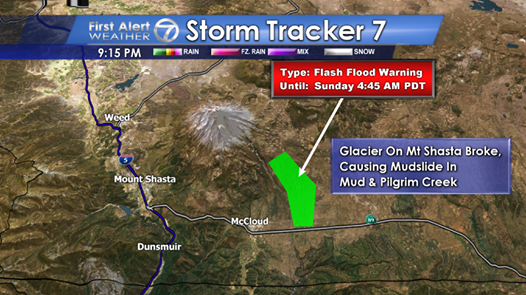
image source
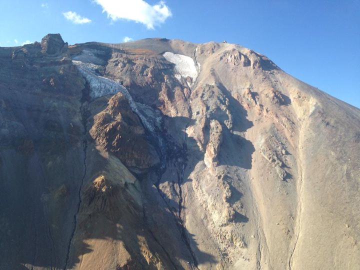
Find this image and many more at the Mt. Shasta Avalanche center FB page.
From what I know of the area, this is probably due to weakening from the sun/drought and not volcanically triggered. Seismicity has been fairly quiet around Mt. Shasta for a while. But the volcano is inherently crumbly, due to heat, gases.
Currently, water is backing up behind the debris flow and could burst downstream at any time.
Glacier breaks off SE flank of Mt. Shasta
12 second video showing mud/flood
Event: Flash Flood Warning
Alert:
THE NATIONAL WEATHER SERVICE IN MEDFORD HAS EXTENDED THE
* FLASH FLOOD WARNING FOR GLACIER INDUCED FLOODING IN...
SOUTH CENTRAL SISKIYOU COUNTY IN NORTHERN CALIFORNIA...
* UNTIL 1045 AM PDT SUNDAY
* AT 443 AM PDT...A GLACIER ON MT SHASTA HAS BROKEN...RELEASING
LARGE QUANTITIES OF MUD...ROCKS AND WATER. THIS IS CAUSING
FLASH FLOODING IN MUD CREEK AND PILGRIM CREEK.
* LAW ENFORCEMENT REPORTS THAT FLOODING IS OCCURRING AT THE
FOLLOWING ROADS: FOREST SERVICE ROAD 31 KNOWN AS WINDING WAY AND
FOREST SERVICE ROAD 13 KNOWN AS PILGRIM CREEK ROAD. BOTH ROADS
ARE CLOSED.
Instructions: FLOOD WATERS ARE MOVING DOWN MUD CREEK AND PILGRIM CREEK FROM MID WAY UP MOUNT SHASTA TO JUST NORTH OF HIGHWAY 89 WHERE WATERS ARE CURRENTLY DAMMED. WATER CONTINUES TO ACCUMULATE UPSTREAM BEHIND THE DEBRIS FLOW AND MAY BREAK FREE AND FLOW DOWNSTREAM AT ANY TIME. A FLASH FLOOD WARNING MEANS FLASH FLOODING IS OCCURRING OR IS IMMINENT. MOST FLOOD RELATED DEATHS OCCUR IN AUTOMOBILES. DO NOT ATTEMPT TO CROSS WATER COVERED BRIDGES...DIPS...OR LOW WATER CROSSINGS. NEVER TRY TO CROSS A FLOWING STREAM... EVEN A SMALL ONE... ON FOOT. TO ESCAPE RISING WATER MOVE UP TO HIGHER GROUND.
Target Area:
Siskiyou
NWS source
edit on 9/21/2014 by Olivine because: brb
edit on 9/21/2014 by Olivine because: (no reason
given)
edit on 9/21/2014 by Olivine because: (no reason given)
Wow, I dug up the seismic station data, and there it is, showing on two stations pretty strong. Give me a few and I'll have waveforms and spectros
posted... Pretty impressive, looks like tremor!
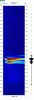
Here it is from another view, spectro and waveform of a piece of it near the onset:
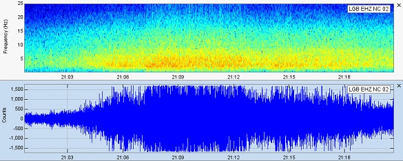
It appears that according to another station, there may have been some additional smaller slides on the northeast side as well after that.
Here it is from another view, spectro and waveform of a piece of it near the onset:
It appears that according to another station, there may have been some additional smaller slides on the northeast side as well after that.
edit
on Sun Sep 21st 2014 by TrueAmerican because: (no reason given)
a reply to: TrueAmerican
Thanks TA, that's where I was heading next. station NC.LGB is nearest, but not publically available except for a few sites--not IRIS though.
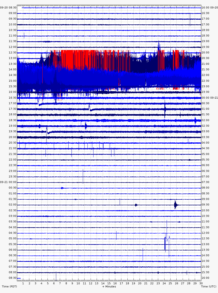
Here is a screenshot of the past 24 hours at Gray Butte, via the Calvo Mt. Shasta monitoring page.
(Note: this station is prone to frequent electronic/technical difficulties)
Here is the spectrogram from USGS for the same station
(click to enlarge)
Thanks TA, that's where I was heading next. station NC.LGB is nearest, but not publically available except for a few sites--not IRIS though.
Here is a screenshot of the past 24 hours at Gray Butte, via the Calvo Mt. Shasta monitoring page.
(Note: this station is prone to frequent electronic/technical difficulties)
Here is the spectrogram from USGS for the same station
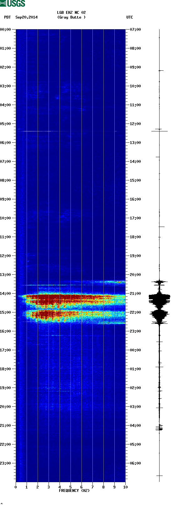
(click to enlarge)
edit on 9/21/2014 by Olivine because: add a few pics
Interesting find Olivine!
Waiting for more in-depth analysis from you and TA on this one.
Waiting for more in-depth analysis from you and TA on this one.
a reply to: sageturkey
I'm working on it, and I know TA will come up with some good stuff.
This is probably unrelated, but there was a relatively deep Mag 3.1 just off the coast of Eureka, CA (and WSW of Mt. Shasta by about 200 kms) 30 minutes prior to the slide.
On Mt. Shasta proper, the most recent quake was this microscopic Mag 0.6 on the 19th, NE of the summit and 7 kms deep. Hardly big enough to break a glacier.
The US Forest Service is speculating about the drought weakening the glacier.
www.redding.com...
ETA:
I'll BRB, I've got to hand over the compy, so my spouse can finalize his fantasy football line-up.
I'm working on it, and I know TA will come up with some good stuff.
This is probably unrelated, but there was a relatively deep Mag 3.1 just off the coast of Eureka, CA (and WSW of Mt. Shasta by about 200 kms) 30 minutes prior to the slide.
On Mt. Shasta proper, the most recent quake was this microscopic Mag 0.6 on the 19th, NE of the summit and 7 kms deep. Hardly big enough to break a glacier.
The US Forest Service is speculating about the drought weakening the glacier.
Shasta-Trinity National Forest wilderness rangers believe the mudslide may be related to the drought, which has left Mt. Shasta’s glaciers exposed to the sun’s heat.
www.redding.com...
ETA:
I'll BRB, I've got to hand over the compy, so my spouse can finalize his fantasy football line-up.
edit on 9/21/2014 by Olivine because: (no reason given)
A lahar is a type of mudflow or debris flow composed of a slurry of pyroclastic material, rocky debris, and water. The material flows down from a
volcano, typically along a river valley.
A Lahar is the future disaster being monitored on Mt Rainer by the NWS.
A Lahar is the future disaster being monitored on Mt Rainer by the NWS.
fantasy football?
Damn, if you were my wife, you'd have a $3k computer of your very own, a 50"+ display, the fastest net connection available, and a 200.00/month allowance for paid scientific journal/document readings. What the heck is he thinking? How dare he stifle one of the best minds on this site!
(JUST kidding)
Global warming has been affecting the US for a while now and this is another sign of it, but unfortunately most people will continue to ignore reality
and realistically it's probably too late to stop it now.
A new
Flash
flood warning was issued 45 minutes ago:
Luckily no one has been hurt or injured, and hopefully that will remain the case.
I'm still looking for aerial footage. The USFS had a flyover this morning.
@TA
You're sweet. Exaggerating my skills by a mile, but very kind.
AT 1035 AM PDT...A GLACIER OUTBURST ON MT SHASTA HAS RELEASED
LARGE QUANTITIES OF MUD...ROCKS AND WATER. THIS IS CAUSING FLASH
FLOODING ON MUD CREEK AND PILGRIM CREEKS.
Luckily no one has been hurt or injured, and hopefully that will remain the case.
I'm still looking for aerial footage. The USFS had a flyover this morning.
@TA
You're sweet. Exaggerating my skills by a mile, but very kind.
This year there is barely any snow capping Shasta's peak. In recent years the cap has receded.
This is surely a cause of warmer temperatures and a persistent drought.
If you look at the picture in the OP, you see there is virtually no snowpack, with the exception of the glaciers.
With no snowpack to cover the glaciers, the "bare roots' of the glaciers , essentially, are exposed to the continuing sun.
Without the protection of snow and ice, they break off and slide.
I, recall so many past years, that the snow held to the mountaintop throughout summer, just pulling up throughout August; by this time of year- storms and accumulation of high altitude snow had already begun.
a reply to: ecapsretuo
I completely agree with you. It wasn't that long ago either.
When I was living in the area, in the '90s, the mountain always had snow covering the glaciers and at least the top 1/5 of edifice in mid summer.
Inciweb has added the Mt. Shasta mud flow to their page. So now we can watch the west burn and follow the flooding all in one place.
I have always been interested in Mt Shasta after finding out the government sealed it to keep Geronimo from using it as a quick tunnel from California
to I believe it was New Mexico.
These lands for a lot of tribes is sacred ground. For some, Mt. Shasta presented the hollow earth theory, for the tribes various opinions but all sacred. The sealing of it has always had me interested since reading about it in school; there was really no big justification for it outside of getting the "enemy"; after he was caught it was allegedly never reopened.
I wonder what are the conditions going on inside of it. When I lived in Frisco, there was a lot of talk about jobs down there mining into it, and that was back in the 90s. If they did mine in there, I wonder is that also contributing to the problem.
originally posted by: Olivine
a reply to: ecapsretuo
I completely agree with you. It wasn't that long ago either.
When I was living in the area, in the '90s, the mountain always had snow covering the glaciers and at least the top 1/5 of edifice in mid summer.
This is the true, and snow would remain at the the top until the following seasonal snows. This year, by about June, there was no snow left on the mountain.
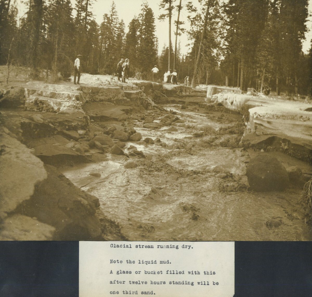
This site documents a similar glacial melt from Mt. Shasta back in 1924.
I'm curious to see if we have a similar chain of events.
Link
Devastating back then, and they got a cold spell in the middle of September that helped slow the mud flow.
Interesting series of events if you read through them all.
Well if the heat continues like it has we may see an increase in frequency of mudflows like these.
Thanks for the info Olivine, will be keeping an eye on this one.
I'm curious to see if we have a similar chain of events.
Link
The 1924 mud flow from Konwakiton Glacier made front page news in the Redding Courier-Free Press six times during the months of August and September. The first article covering the story in this newspaper, on the front page, was:
BREAKING UP OF GLACIER AT TOP OF MT. SHASTA MUDDIES WATER Water of River Muddiest It Has Ever Been Roads Washed Out by Rush of Water Down Mountain
(By the Associated Press) SACRAMENTO, Aug. 18
A veritable river of mud, boulders and ashes extending in width from a few hundred yards to half mile, in some places fifteen to 20 feet deep, is flowing from the mouth of Mud Creek canyon, eight miles above McCloud, on the slope of Mount Shasta, into the McCloud river, says a dispatch to the Sacramento Bee. The sudden flood is attributed by old residents to a sudden break up of the glacier exposed to sun's rays at the top of an extinct volcano. McCloud's water pipes were broken for two days. The water of the Sacramento river was the muddiest it has been for years...
Devastating back then, and they got a cold spell in the middle of September that helped slow the mud flow.
MT. SHASTA TOWNS SAVED Cave-in Dams Flood of Lava, Glacier Mud
Sudden Cold Spell Sets Natural Formation, Saving McCloud from Torrent DANGER IS INCREASING
Lake Forming on Mountainside as Snow Waters are Impounded
SACRAMENTO, Sept. 19
Freezing temperatures at the base of Mount Shasta early today checked the stupendous flow of ashes, mud and lava formation, which poured down the sides of the mountain before a torrent of flood waters, imperilling the lumber town of McCloud, five miles distant.
Interesting series of events if you read through them all.
Well if the heat continues like it has we may see an increase in frequency of mudflows like these.
Thanks for the info Olivine, will be keeping an eye on this one.
edit on 22-9-2014 by Observationalist because: Added text from link
edit on 22-9-2014 by Observationalist because: (no reason
given)
new topics
-
Joe Biden and Donald Trump are both traitors
US Political Madness: 1 hours ago -
I'm new here. Avid conspiracy fan.
Introductions: 1 hours ago -
Denmark's Notre-Dame moment - 17th Century Borsen goes up in Flames
Mainstream News: 2 hours ago -
We need less laws in the UK not more
General Chit Chat: 5 hours ago -
The Baloney aka BS Detection Kit
Social Issues and Civil Unrest: 10 hours ago -
Suspected Iranian agent working for Pentagon while U.S. coordinated defense of Israel
US Political Madness: 10 hours ago
top topics
-
Suspected Iranian agent working for Pentagon while U.S. coordinated defense of Israel
US Political Madness: 10 hours ago, 15 flags -
USO 10 miles west of caladesi island, Clearwater beach Florida
Aliens and UFOs: 17 hours ago, 9 flags -
The Baloney aka BS Detection Kit
Social Issues and Civil Unrest: 10 hours ago, 6 flags -
We need less laws in the UK not more
General Chit Chat: 5 hours ago, 4 flags -
Denmark's Notre-Dame moment - 17th Century Borsen goes up in Flames
Mainstream News: 2 hours ago, 4 flags -
How does my computer know
Education and Media: 13 hours ago, 3 flags -
I'm new here. Avid conspiracy fan.
Introductions: 1 hours ago, 1 flags -
Joe Biden and Donald Trump are both traitors
US Political Madness: 1 hours ago, 0 flags
active topics
-
Girl 11, Barred From Starting a Faith Club but Classmates are Allowed Pride Group
Education and Media • 351 • : FlyersFan -
Candidate TRUMP Now Has Crazy Judge JUAN MERCHAN After Him - The Stormy Daniels Hush-Money Case.
Political Conspiracies • 213 • : SomeStupidName -
Joe Biden and Donald Trump are both traitors
US Political Madness • 12 • : andy06shake -
Anti-Israel Protesters in CHICAGO Chant 'Death to Israel and 'Death to America'
Social Issues and Civil Unrest • 42 • : marg6043 -
-@TH3WH17ERABB17- -Q- ---TIME TO SHOW THE WORLD--- -Part- --44--
Dissecting Disinformation • 487 • : fringeofthefringe -
I'm new here. Avid conspiracy fan.
Introductions • 3 • : TheDiscoKing -
The Reality of the Laser
Military Projects • 28 • : confuzedcitizen -
It has begun... Iran begins attack on Israel, launches tons of drones towards the country
World War Three • 714 • : ImagoDei -
Canadian Police Urge Citizens To Avoid Conflict With Armed Robbers By Leaving Keys At Front Door
Social Issues and Civil Unrest • 69 • : MrGashler -
Suspected Iranian agent working for Pentagon while U.S. coordinated defense of Israel
US Political Madness • 23 • : Consvoli
25