It looks like you're using an Ad Blocker.
Please white-list or disable AboveTopSecret.com in your ad-blocking tool.
Thank you.
Some features of ATS will be disabled while you continue to use an ad-blocker.
38
share:
Interesting reports and consideration here on the ancient engineering projects that transformed the Kopais basin of Northern Greece, modern engineers
attempting to recreate similar projects are only just begining to realize the scale and complexity of these early works which stretch back into the
pre-historic era.
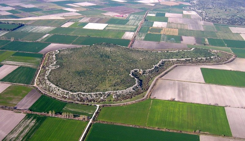
The huge Citadel of Glas with it's cyclopean walls was at the heart of the region.
Current investigations at Glas Citadel
Prehistoric Engineering at Lake Copais.
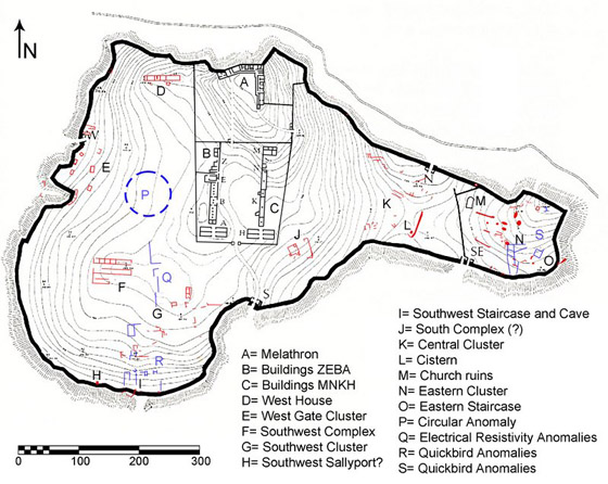
A very impressive site,and generally what lay behind the rise of Bronze age civilizations was impressive water management projects.
Glas Project Website
The huge Citadel of Glas with it's cyclopean walls was at the heart of the region.
Current investigations at Glas Citadel
Prehistoric Engineering at Lake Copais.
The ancient engineers drained marshland through a complex drainage control system, diverting six rivers and streams from the basin into two enormous canals that converged at the northeastern edge of the Kopais basin. The canals were flanked by massive embankments reinforced at some locations with double Cyclopean revetments that supported roads and were supplied with underground drains and channels directing water overflow into artificial polders, natural cavities and sinkholes, or to the Larymna bay. Archaeologists estimate that as much as 2,000,000 cubic meters of earth were moved to build dykes and embankments along the periphery of the basin, with more than 250,000 cubic meters of stone used to face the embankments.

The district comprising the Copaic basin was at the time of the Trojan war, and probably long anterior even to that, one of the richest and most populous parts of Greece. Its wealth of myth would prove this, even if historic record were wanting. A circle with a radius of twelve or fifteen miles drawn around Copais will include more sites famous in romance and in history than almost any other place of like extent on earth. The Bœotian plain is nearly shut in by mountains the bare mention of whose names calls up a vast panorama of heroic figures, with a shadowy background of demigods and of gods reaching back into cloudland

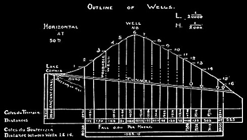
A still more ambitious undertaking of the ancient engineers was an attempt to penetrate the Hill of Kephalari at the north- east end of the lake by a tunnel more than a mile and a quarter long. This hill, a depression on the flank of Mount Ptoum, has a maximum height of one hundred and forty-seven metres above the sea and fifty-two metres above the bottom of Lake Copais. Across this depression, from near the openings of the Katabothra of Bynia in the Bay of Kephalari, runs a line of ancient wells or shafts in a general direction from southwest to northeast, not in a straight line, but following the contour of the hill, ending on the east side not far from where the katabothra opens into the Valley of Larymna

When we take into consideration the difficulties attending excavation in so marshy a soil, and of transporting across it the heavy stones for the embankments, and note the immensity of the plan and the thoroughness and solidity of its execution, we are moved to admiration for the engineers who conceived and built the great works which rendered this part of Boeotia habitable before the dawn of history.
A complete ancient system of hydraulic works dating from so remote a period that all record or tradition of their construction has been lost. This system, so vast and comprehensive as to excite the wonder of modern engineers, taking into consideration the primitive appliances of the ancients, served to convert this now miasmatic basin into a fruitful plain

A very impressive site,and generally what lay behind the rise of Bronze age civilizations was impressive water management projects.
Glas Project Website
edit on Kam731193vAmerica/ChicagoSunday1331 by Kantzveldt because: (no reason given)
a reply to: Kantzveldt
So cool. Great thread K.
I would love to have seen these places in their prime. The majority of people were living a pretty basic life and just around the corner there's this advanced city. It's easy to see how men became kneelers. These men were gods who created these works. At least to the locals.
a reply to: zardust
It was awesome, and the drainage project would have to pre-date the citadel.
It was awesome, and the drainage project would have to pre-date the citadel.
The Kopais drainage project was colossal by both ancient and modern standards: it is estimated that 2,000,000 cubic meters of earth were moved to build the extensive dykes and massive embankments (2m high and 30m wide) running for many kilometers on the periphery of the basin, more than 250,000 cubic meters of stone were used to revet the embankments, and the water overflow of the main canal is estimated at 100 cubic meters per sec. The area once named “Arne ” was still remembered as “multi-vined” in the Iliad (“polystaphylon Arne,” II 507) and Orchomenos as one of the richest kingdoms of the heroic past (Iliad I. 381-382), whose wealth and power was associated in the ancient literary sources with the cultivation of the drained lake (Strabo IX.2.40; Pausanias IX.17.2; Diodorus IV.18.7).
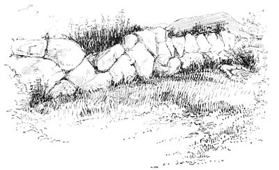
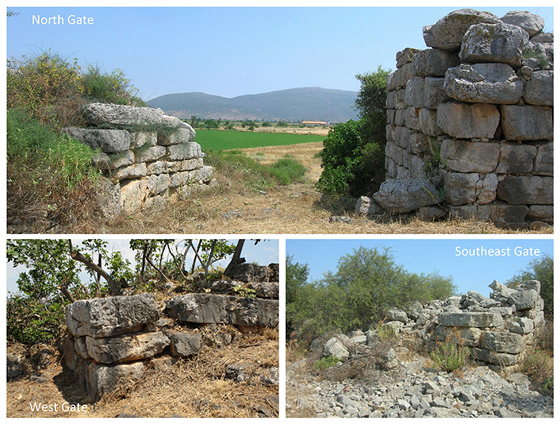
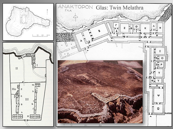
A vast citadel, today known as “Gla(s)” or “Kastro” (=“castle”), was built on top of an island-like, flat-topped bedrock outcrop rising 20-40 m above the plain below and encompassing an area of 20 ha or 49.5 acres (ten times the size of Tiryns and seven times that of Mycenae) at the north-eastern edge of the Kopais basin. The Mycenaean citadel of Glas was fortified by a massive cyclopean wall (5.50-5.80m thick) which runs along the brow of the rocky natural platform for approximately 3 kms, features four gates (including one double gate), and encompasses a cluster of three adjacent and intercommunicating central enclosures.
a reply to: Kantzveldt
S&F as so often for your marvellous threads its almost impossible to imagine such a terrific task and how they accomplished it. For me this is one of the definetive proofs of an ancient civilisations that we have lost all re4cord and memory of. Its also that link to the 'giants' who may have constructed this.
I also reminds me of Nan Madol and the construction within water that was so brilliantly done. These ancient peoples seem to have had excellent knowledge and capability, some skills also that we have had to learn again. There is a reason for building in stone, which is obviously one of the hardest materials to use and that is, that precious little that we have constructed in our modern times will ever survive to tell generations in the far future we even existed.
a reply to: zardust
I suspect with changing sea levels ancient societies had to become expert water managers. Its something the Sumerian and ancient tablets mention managing the water supply. ( as documented in Christian O"Brien's books).
Apart from what little we can see of their existence I do wonder if they actually led such a basic lifestyle as we tend to think from our modern techno world. - with which we cannot yet completely mimic or construct some of the things they created for their living space. We have lost the information about how they managed the plants and health needs of their people through dumbing down herbalists in favour of our modern bigpharma.
I was struct when walking through Pergamon (OK its in ruins) at the elegance and beauty of what was left of it. Nowhere one walks today has that ancient, elegant and expansive feel to it.
I am simply wondering if life would not be of a better quality for humans if we had a more basic lifestyle. Today for me its far too complicated, complex, a technology that has to be (for me at least ) chased after and what exactly have I gained from it would be off-post.
I can see why Greece held such a high place and respect in the ancient world the construction Kantzveldt has shown us is truly awesome.
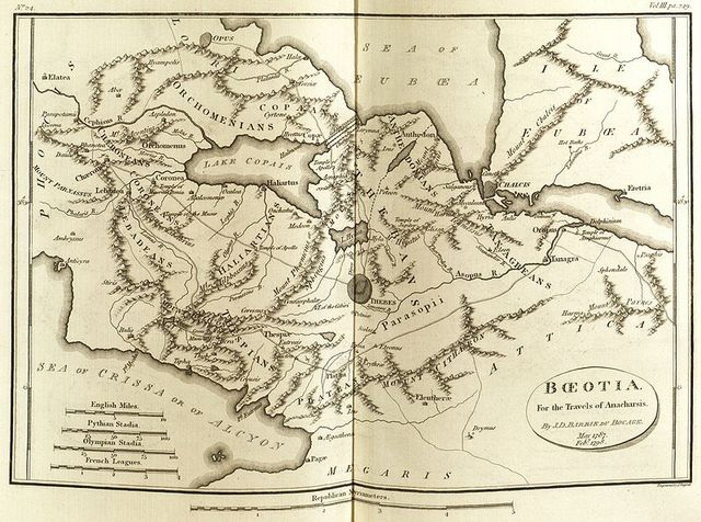
Ok, so If I understand this right. There was a lake recently drained by British and French engineers in the 19th century. One that was mentioned by Greek authors all the way back to 500 bc.
[ The lake is shown in the map above, from before it was drained. ]
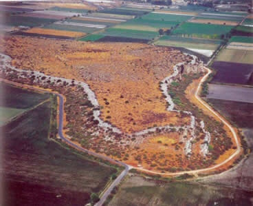
And when they drained it.
They found this.
I've read first about Lake Copais in a book by Robert Charroux titled 'Le livre des secrets trahis'(Paris, 1965). In it he wrote about the lake in a short section. He began with that the fables about Heracles only hide the truth. As the water-level began to lower at the end of the nineteenth century, "the ruins of a city aged 5000 years" has come to the daylight. The archaeologists have discovered with amazement a channel system, which was used for draining the water to the sea... This place was destroyed by a cataclysm, and it has been erased from the memory of the Greeks, which they accounted for Heracles. It had collecting-channels, immense dams and a tunnel, which cut through a mountain and was ventilated by air-shafts. "First and last, these all contributed to a titanic work", said Charroux, "which couldn't be completed in the time of Pericles's Greece, or even in our own."(1965)
Greece before the Greeks
edit on 13-7-2014 by mikegrouchy because: format
a reply to: mikegrouchy
I'm not so sure that take on things is correct, Lake Kopais is still very much there as far as i'm aware. My understanding is that the marshy flat wetlands surrounding the Lake which is the entire plain surrounded by the mountains was drained in the Pre-historic period through monumental engineering projects, and that this became a highly fertile agricultural plain often mentioned during the historic period.
The citadel occupies raised ground which would have been an island when the region was wetlands, the ruins upon it thus far are dated back to the Middle Bronze age period of Mycenae, and are in area seven times larger than their capital with surrounding walls of 3km, of course the region would probably already have been drained for those stones to have been transported there, but such stones were also used in the earlier engineering projects to support raised embankments and canals, so there is the question of whether they were scavenged.
Edit; It does in fact seem that the Lake has been fully drained away and is no longer there...
a reply to: Shiloh7
Yes the context of these early water management projects is highly interesting, in the Atrahasis myth the Anunaki complain of all the ditches they are having to dig in order to prepare the ground for Sumerian civilization, the Anunaki in that context probably Earth born rulers that considered themselves related to the Celestial Anunaki.
The same situation prevailed in Egypt and the Indus valley and the first coastal cities of Peru, they were entirely dependent upon irrigation and water management and the same principles seem to apply also here to Boetia, one of my favorite pieces is the large Inca stone model which demonstrates all the principles of water management.
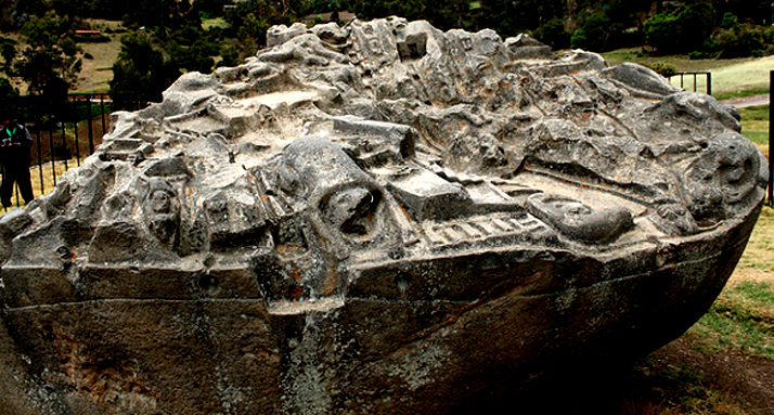
Thesse works though really were something else!
And i'm not so sure it was the 'Minyans''
TThe Drainage Project
I'm not so sure that take on things is correct, Lake Kopais is still very much there as far as i'm aware. My understanding is that the marshy flat wetlands surrounding the Lake which is the entire plain surrounded by the mountains was drained in the Pre-historic period through monumental engineering projects, and that this became a highly fertile agricultural plain often mentioned during the historic period.
The citadel occupies raised ground which would have been an island when the region was wetlands, the ruins upon it thus far are dated back to the Middle Bronze age period of Mycenae, and are in area seven times larger than their capital with surrounding walls of 3km, of course the region would probably already have been drained for those stones to have been transported there, but such stones were also used in the earlier engineering projects to support raised embankments and canals, so there is the question of whether they were scavenged.
Edit; It does in fact seem that the Lake has been fully drained away and is no longer there...
a reply to: Shiloh7
Yes the context of these early water management projects is highly interesting, in the Atrahasis myth the Anunaki complain of all the ditches they are having to dig in order to prepare the ground for Sumerian civilization, the Anunaki in that context probably Earth born rulers that considered themselves related to the Celestial Anunaki.
The same situation prevailed in Egypt and the Indus valley and the first coastal cities of Peru, they were entirely dependent upon irrigation and water management and the same principles seem to apply also here to Boetia, one of my favorite pieces is the large Inca stone model which demonstrates all the principles of water management.

Thesse works though really were something else!
The aim was to channel runoff waters from the Melas, Kephisos and Herkyna Rivers and some lesser streams, which became swollen during the winter and caused severe flooding. However, when the excess waters were removed, the marsh dried up, hence creating arable land.
Diking was done by building stone walls inside the lake basin so that an artificial channel existed between the dike wall and the natural lake bank. The width of the dikes was 40 m to 50 m with the channel between being 40 m to 60 m wide. Where the lake bank was too low, another wall was erected so that this particular area had an artificial channel between two walls.
The Minyans now had, in effect, a moat completely surrounding the lake with the mouth passing its runoff waters downstream, leading to an artificial channel 9 km long, then through a manmade tunnel 2.2 km in length through solid rock, continuing along a natural watercourse, and finally emptying into the Euboian Gulf which is part of the Aegean Sea.
In some areas such as the Kephisos and Melas river outlets, where runoff was excessive due to occasional freshets, extra precautions were taken. This additional work consisted of a 2 m thick double wall on either side of a 27 m earth filled section, giving a total dike width of some 66 m.
An artificial 9 m wide and 9 km long channel was dug from a point northeast of Topolia to Binia, picking up additional waters from the moat area east of Gla. They now had rushing waters funnelled into the underground tunnel from the east end of the channel at Binia running northeasterly for a mile and a third.
The tunnel, constructed about 3300 years ago was quite a project. Besides being 2230 m long, it also had 16 vertical square shafts placed at intervals between 100 m and 200 m. Depths varied between 18 m and 63 m. Minyan workers then excavated, at an 11% grade between the shafts. How they stayed on course and maintained their slope are mysteries. The shafts were used for inspection and maintenance purposes the same as our manholes of today.
Underground tunnels at irregular locations were found at Pyrgos, Topolia and the eastern side of the lake; however, their specific purpose has yet to be resolved.
And i'm not so sure it was the 'Minyans''
TThe Drainage Project
edit on Kam731193vAmerica/ChicagoSunday1331 by Kantzveldt because: (no reason given)
edit on
Kam731193vAmerica/ChicagoSunday1331 by Kantzveldt because: (no reason given)
a reply to: Kantzveldt
It seems to be that we have all the signs of a mysterious civilisation - whether these were ouir forefathers or a completely different civilisation who knows - I would love to find out though as I guess you would.
It seems to be that we have all the signs of a mysterious civilisation - whether these were ouir forefathers or a completely different civilisation who knows - I would love to find out though as I guess you would.
Awsome Kantz,
I am wondering if they were contemporary to the underground city dug out of limestone in the same basic area......
I am wondering if they were contemporary to the underground city dug out of limestone in the same basic area......
a reply to: Shiloh7
Even according to the Greeks at some point the system was compromised by Hercules, thus they were the stuff of legend and various attempts were made in the classical period to get the system up and running again properly.
This paper does look at dating evidence for the parts of the system, but acknowledges this was ever ongoing in terms of repairs and maintaining.
Drainage works of Kopais Paper
a reply to: stirling
Which do you have in mind...?
Could be they relate to this system as there were tunnels and shafts cut into limestone at many places.
Limestone tunnels
Even according to the Greeks at some point the system was compromised by Hercules, thus they were the stuff of legend and various attempts were made in the classical period to get the system up and running again properly.
This paper does look at dating evidence for the parts of the system, but acknowledges this was ever ongoing in terms of repairs and maintaining.
As excavation evidence and tradition attest (e.g. Bulle 1907; Iakovidis 1995), the most important centre in northern Boeotia was Orchomenos, in the northwest corner of the Kopais lake/plain.
Furthermore, in the memory of the ancients, the legendary wealth of Orchomenos was due to the cultivation and exploitation of the drained Kopais Lake (Il. 9.381; Str. 9.2.40.). The power and plenty enjoyed by Orchomenos lasted, according to ancient tradition, until Heracles took vengeance on the King of Orchomenos, blocking the exit of the Kephisos River towards the sea, and thus flooding the Kopais once again (Apollod. 2.4.11, Diod. Sic.4.18.6
The enormous installation of Glas (E.g. Iakovidis 1983; 1998) is close to Orchomenos, built on a natural island in the east creek of the lake. The picture of the prehistoric drainage works in Kopais remained ambiguous, since the theories (Knauss et al. 1984) that have been proposed concerning their function and their precise date within the Bronze Age, were based solely on indications from the surface survey and not on documentation after archaeological or geophysical methods
Drainage works of Kopais Paper
a reply to: stirling
Which do you have in mind...?
Could be they relate to this system as there were tunnels and shafts cut into limestone at many places.
A still more ambitious undertaking of the ancient engineers was an attempt to penetrate the Hill of Kephalari at the north- east end of the lake by a tunnel more than a mile and a quarter long. This hill, a depression on the flank of Mount Ptoum, has a maximum height of one hundred and forty-seven metres above the sea and fifty-two metres above the bottom of Lake Copais. Across this depression, from near the openings of the Katabothra of Bynia in the Bay of Kephalari, runs a line of ancient wells or shafts in a general direction from southwest to northeast, not in a straight line, but following the contour of the hill, ending on the east side not far from where the katabothra opens into the Valley of Larymna. There are sixteen of these wells, cut through the hard, gray limestone of which the mountain is composed, and carefully squared, with an average horizontal section of three to four metres. The first shaft, on the west side, is five hundred metres from the lake; the sixteenth, on the east side, two hundred and twenty-five metres from the opening. The wells are at an average distance from each other of about one hundred and sixty metres, and the whole distance from opening to opening is about twenty-four hundred metres.
Who were the authors of these great works concerning which history is silent and which are themselves their only witnesses ? Perhaps this question will never be satisfactorily answered.
Limestone tunnels

edit on Kpm731193vAmerica/ChicagoSunday1331 by Kantzveldt because: (no reason given)
a reply to: Kantzveldt
Very nice thread, lots of 'normal' sites that get ignored for the more popular. This site is impressive (actually the whole areas is strewn with ruins) I spent a few days looking at these and other ruins some years ago, I was more interested in Thebes at that time. The former lake bed was drained in the 19th century so are we talking about a different lake?
To Shiloh: er no the dating for these ruins is to around 1400 BC not quite far enough back for your 'mysterious civilization'. These ruins are solidly associated with the Mycenaean.
a reply to: Hanslune
Nevertheless it would show our understanding of Mycenea is still woeful and that they were at least as far as infrastructor is concerned far more advanced than we today give them credit, it also show's that there population must have been very large at the time making the intensive agriculture necessary and in part explaining how they had enough manpower to erect so many cyclopedean structure's.
Fascinating and I for one find this as impressive as the pyramid's, especially given the time but sadly other than the later greek culture which inherited from and grew from them they left little to give us a true impression of there culture at that time, after all the greek myths are based mainly in there period but what myths did they displace and what history and intrigue we may never truly know.
originally posted by: LABTECH767
a reply to: Hanslune
Nevertheless it would show our understanding of Mycenea is still woeful
Depending on the nature of your yard stick our knowledge of all the ancient civilizations is woeful - unfortunately.
and that they were at least as far as infrastructor is concerned far more advanced than we today give them credit,
They've been given credit not sure what you're meaning is here.
Fascinating and I for one find this as impressive as the pyramid's,
I would consider it more impressive as more work was probably done here and for a useful purpose than at Giza, where aggrandizement for burial and religion is never as valuable as survivability.
a reply to: Hanslune
Yes the lake was drained (again) in the 19th century and is no longer there. Construction there is generally credited by the Greeks to the Minyans who were of the Mycenae period and their monuments indistinguishable, but the site of Orchomenus had been continuously settled from the Neolithic period onward, the followers of the in legend Divine Minyas having settled later in the area.
Yes the lake was drained (again) in the 19th century and is no longer there. Construction there is generally credited by the Greeks to the Minyans who were of the Mycenae period and their monuments indistinguishable, but the site of Orchomenus had been continuously settled from the Neolithic period onward, the followers of the in legend Divine Minyas having settled later in the area.
Awesome stuff! SnF
I read something similar about large hydrological works in the Amazon basin or there abouts. Very old. I wish I could find the link.
I think we tend to underestimate ancient humans ability to manipulate their environment. How the heck they moved so much soil is amazing though. It would take an army of dudes with shovels to make all that happen. The organization would be something
This is awesome! Thanks for posting, truly amazing information here, I hope that further research is done that will actually be treated seriously by
mainstream historians.
originally posted by: TheIceQueen
This is awesome! Thanks for posting, truly amazing information here, I hope that further research is done that will actually be treated seriously by mainstream historians.
Ah, the research is being done by mainstream archaeologists, 99% of what we know of this culture comes from the orthodox scientific inquiry.....
new topics
-
Intro once again
Introductions: 1 minutes ago -
University student disciplined after saying veganism is wrong and gender fluidity is stupid
Education and Media: 1 hours ago -
Geddy Lee in Conversation with Alex Lifeson - My Effin’ Life
People: 2 hours ago -
God lived as a Devil Dog.
Short Stories: 2 hours ago -
Police clash with St George’s Day protesters at central London rally
Social Issues and Civil Unrest: 4 hours ago -
TLDR post about ATS and why I love it and hope we all stay together somewhere
General Chit Chat: 5 hours ago -
Hate makes for strange bedfellows
US Political Madness: 7 hours ago -
Who guards the guards
US Political Madness: 9 hours ago -
Has Tesla manipulated data logs to cover up auto pilot crash?
Automotive Discussion: 11 hours ago
top topics
-
Hate makes for strange bedfellows
US Political Madness: 7 hours ago, 14 flags -
Who guards the guards
US Political Madness: 9 hours ago, 13 flags -
whistleblower Captain Bill Uhouse on the Kingman UFO recovery
Aliens and UFOs: 16 hours ago, 11 flags -
Police clash with St George’s Day protesters at central London rally
Social Issues and Civil Unrest: 4 hours ago, 7 flags -
TLDR post about ATS and why I love it and hope we all stay together somewhere
General Chit Chat: 5 hours ago, 5 flags -
University student disciplined after saying veganism is wrong and gender fluidity is stupid
Education and Media: 1 hours ago, 3 flags -
Has Tesla manipulated data logs to cover up auto pilot crash?
Automotive Discussion: 11 hours ago, 2 flags -
God lived as a Devil Dog.
Short Stories: 2 hours ago, 2 flags -
Geddy Lee in Conversation with Alex Lifeson - My Effin’ Life
People: 2 hours ago, 2 flags -
Intro once again
Introductions: 1 minutes ago, 1 flags
active topics
-
Spectrophilia - Women Who Have Had Affairs With Ghosts Say Spooks Are Better Lovers Than Real Men
Paranormal Studies • 28 • : FlyersFan -
Intro once again
Introductions • 0 • : Angrybrewer2 -
University student disciplined after saying veganism is wrong and gender fluidity is stupid
Education and Media • 6 • : Consvoli -
Police clash with St George’s Day protesters at central London rally
Social Issues and Civil Unrest • 35 • : BedevereTheWise -
Thousands Of Young Ukrainian Men Trying To Flee The Country To Avoid Conscription And The War
Other Current Events • 119 • : FlyersFan -
Europe declares war on Russia?
World War Three • 65 • : Freeborn -
Candidate TRUMP Now Has Crazy Judge JUAN MERCHAN After Him - The Stormy Daniels Hush-Money Case.
Political Conspiracies • 731 • : Threadbarer -
"We're All Hamas" Heard at Columbia University Protests
Social Issues and Civil Unrest • 248 • : FlyersFan -
-@TH3WH17ERABB17- -Q- ---TIME TO SHOW THE WORLD--- -Part- --44--
Dissecting Disinformation • 626 • : cherokeetroy -
The Superstition of Full Moons Filling Hospitals Turns Out To Be True!
Medical Issues & Conspiracies • 19 • : FloridaManMatty
38

