It looks like you're using an Ad Blocker.
Please white-list or disable AboveTopSecret.com in your ad-blocking tool.
Thank you.
Some features of ATS will be disabled while you continue to use an ad-blocker.

Wild Wyoming cloud wows weatherwatchers
page: 2share:
a reply to: semperfortis
Very very impressive !!
I was once close to a tornado in the states, not close enough to see it (could be a good thing) but just the wind...craaaaazy !!! Now, if I saw something like that there are two possibilities. Either I die from being scared to death or need of new underwear...if I survive.
Nature is absolutely beautiful and amazing yet so deadly at the same time.
S&F for sure !
awesome stuff!
i've lived in WY and IL and texas, among other places, in the states and the only time i got a little scared was in IL with a lightning storm.
i swear you couldn't make it with CGI, it was pretty heavy duty! lol!
i been through hurricanes and walked through a typhoon 8 because the transportation was halted.
tornado's all the time in IL and texas. nothing spooks me except that lightning storm tho.
never did see an actual tornado on the ground, lots of super cells.
we are so small it's ridiculous, compared to nature.
It's even got a beautiful light bluish hue, sun dancin' off it, just nice.
Those who get that reference are my hero, lol.
Those who get that reference are my hero, lol.
a reply to: semperfortis
Oh, I'm willing to bet you ain't seen nothing yet.
I gotta start taking pictures again.
Enjoy the calm before the real storms.
Oh, I'm willing to bet you ain't seen nothing yet.
I gotta start taking pictures again.
Enjoy the calm before the real storms.
originally posted by: semperfortis
This is both really cool and really frightening
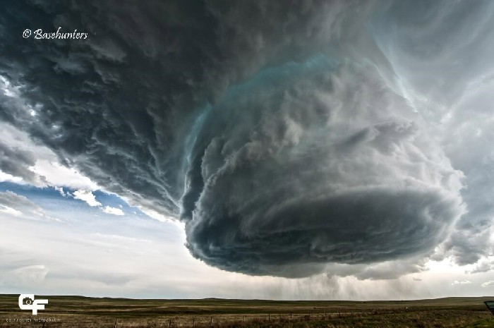
A phenomenal shot of a massive cloud Sunday near Clareton, Wyo., has been making the rounds on social media today.
The photo was taken by the Basehunters storm chasers group, who are "committed to capturing the most unique and close-up tornado footage on the market," according to their Facebook page. It shows the rotating updraft of a supercell thunderstorm over eastern Wyoming, according to Weather Channel meteorologist Jon Erdman.
Supercells are the largest, strongest and longest-lasting thunderstorms. They are most common on the Great Plains.
Known as a "low-precipitation" supercell, these types of storms seldom produce heavy rain or tornadoes, though they can produce large hail, Erdman said.
I have traveled extensively all over the United States and even abroad and I have seen my share of strange weather but nothing like this..
Semper
I am man.
I can control nature and affect clima-. . . . . .
oooooohhhhhhhhhhhhhhh sh!t!
RUN!
originally posted by: Night Star
It's a good thing I come to ATS and discover these things are normal, because if I ever saw that without knowing I'd be scared to death!
You should be afraid of something like that.
Very afraid.
I would totally freak out if i saw that in person!! Im a big sook but in my defense that does have an apocalyptic look to it.. Lol.
a reply to: Phage
Care to speculate on how tall that cell is?
The ground in that area is around 4,500 ft above sea level.
I've seen storms in Wyoming before, some produce micro-bursts that literally blow fully loaded trucks off the road like toys... Also seen it snow in the high elevations as late as mid-June...
Care to speculate on how tall that cell is?
The ground in that area is around 4,500 ft above sea level.
I've seen storms in Wyoming before, some produce micro-bursts that literally blow fully loaded trucks off the road like toys... Also seen it snow in the high elevations as late as mid-June...
This is what happens when Native Americans have firewater
at a raindance.
at a raindance.
I'm from Douglas, WY, which isn't far from where this was filmed. Wyoming weather is not for the weak. Winters can be long and brutal. In fact I
talked to my Dad this past weekend and he mentioned they had snow just a week or two ago (altitude of about 5,000 feet). Not uncommon for those
parts. I remember once checking the weather before I walked to school. Weather report had a temperature of about -45, winds at a steady 45-50mph,
and a wind chill at about -80. I didn't go to school that day.
Springs are pleasant, but don't let a nice day fool ya. You can get any type of weather you can imagine, to include hurricane force winds. Summers where I'm from are hot and dry with temps that can easily get up to triple digits in a hotter summer. Whenever a storm comes through the clouds never disappoint. Seen several super cells form out in the thunder basin national grasslands. They move across the land pretty quickly, and tornados aren't incredibly common.
People always ask me "what's there to do in Wyoming". A favorite response of mine is..."you do what you can while you can, based on the weather". If you've never been to Wyoming, it's a beautiful place to travel through. And many of the small towns are like going back in time.
Big clouds & weird dreams....
IMO this is an excellent movie.
Don't know if anyone agrees, or if anyone's seen it or heard of it for that matter.
IMO this is an excellent movie.
Don't know if anyone agrees, or if anyone's seen it or heard of it for that matter.
Ahh, this just makes me homesick. In the Arizona desert we got tons of wicked weather and spectacular cloud formations. Microbursts, super cells, and
90+ mph winds are standard fare in the summer months. Awesome pic none the less.
a reply to: semperfortis>>> I watched vertical lightning last summer that was unusual and pretty intense. Huge bolts of
lightning leapt vertically from cloud to cloud never touching the ground. They happened with such frequency that the storm clouds were kept
illuminated.
But this was amazing. They showed a hole in the clouds that just happened and that was otherworldly as well.
But this was amazing. They showed a hole in the clouds that just happened and that was otherworldly as well.
Wonder why the photographer is so far away- Must be a Seal,GB or Marine
a reply to: semperfortis
Wow. This group could easily license this photo and make some money for equipment and expenses. Amazing.
Wow. This group could easily license this photo and make some money for equipment and expenses. Amazing.
new topics
-
Hate makes for strange bedfellows
US Political Madness: 1 hours ago -
Who guards the guards
US Political Madness: 4 hours ago -
Has Tesla manipulated data logs to cover up auto pilot crash?
Automotive Discussion: 6 hours ago -
whistleblower Captain Bill Uhouse on the Kingman UFO recovery
Aliens and UFOs: 11 hours ago
top topics
-
CIA botched its handling of sexual assault allegations, House intel report says
Breaking Alternative News: 16 hours ago, 11 flags -
whistleblower Captain Bill Uhouse on the Kingman UFO recovery
Aliens and UFOs: 11 hours ago, 10 flags -
Hate makes for strange bedfellows
US Political Madness: 1 hours ago, 9 flags -
Who guards the guards
US Political Madness: 4 hours ago, 8 flags -
1980s Arcade
General Chit Chat: 13 hours ago, 5 flags -
Teenager makes chess history becoming the youngest challenger for the world championship crown
Other Current Events: 15 hours ago, 4 flags -
Deadpool and Wolverine
Movies: 14 hours ago, 4 flags -
Has Tesla manipulated data logs to cover up auto pilot crash?
Automotive Discussion: 6 hours ago, 2 flags
active topics
-
whistleblower Captain Bill Uhouse on the Kingman UFO recovery
Aliens and UFOs • 14 • : alldaylong -
Candidate TRUMP Now Has Crazy Judge JUAN MERCHAN After Him - The Stormy Daniels Hush-Money Case.
Political Conspiracies • 683 • : Vermilion -
Hate makes for strange bedfellows
US Political Madness • 12 • : network dude -
"We're All Hamas" Heard at Columbia University Protests
Social Issues and Civil Unrest • 234 • : KrustyKrab -
IDF Intel Chief Resigns Over Hamas attack
Middle East Issues • 42 • : TheWoker -
Deadpool and Wolverine
Movies • 4 • : FlyersFan -
British TV Presenter Refuses To Use Guest's Preferred Pronouns
Education and Media • 113 • : Consvoli -
Fast Moving Disc Shaped UFO Captured on Camera During Flight from Florida to New York City
Aliens and UFOs • 20 • : MaximusNewmanus -
1980s Arcade
General Chit Chat • 14 • : ATruGod -
MULTIPLE SKYMASTER MESSAGES GOING OUT
World War Three • 94 • : Irishhaf