It looks like you're using an Ad Blocker.
Please white-list or disable AboveTopSecret.com in your ad-blocking tool.
Thank you.
Some features of ATS will be disabled while you continue to use an ad-blocker.

La Quemada, México another archeological place that doesn't fit..
page: 2share:
Hi, and thanks...
Are the rounded columns of one hewn stone? Thery looked like theyre cast cement of some kind....
Are the rounded columns of one hewn stone? Thery looked like theyre cast cement of some kind....
Hi, and thanks...
Are the rounded columns of one hewn stone? Thery looked like theyre cast cement of some kind....
Are the rounded columns of one hewn stone? Thery looked like theyre cast cement of some kind....
reply to post by kix
Thanks for a terrific thread S&F for you.
I looked at the situation of La Quemada and wondered if it was a trading post of some kind because it is almost an outpost or stopping off post for trips between the main sites in the middle of Mexico and the one site at the top of Mexico.
The care taken in building it is impressive and it must have served a purpose rather than just a town. I do wonder if the animal population posed any type of threat and so they built high. The dates for some sites that have a similar building technique are considerably older than La Quemada which is also a puzzle, unless it has been built over an older site.
weirdguy
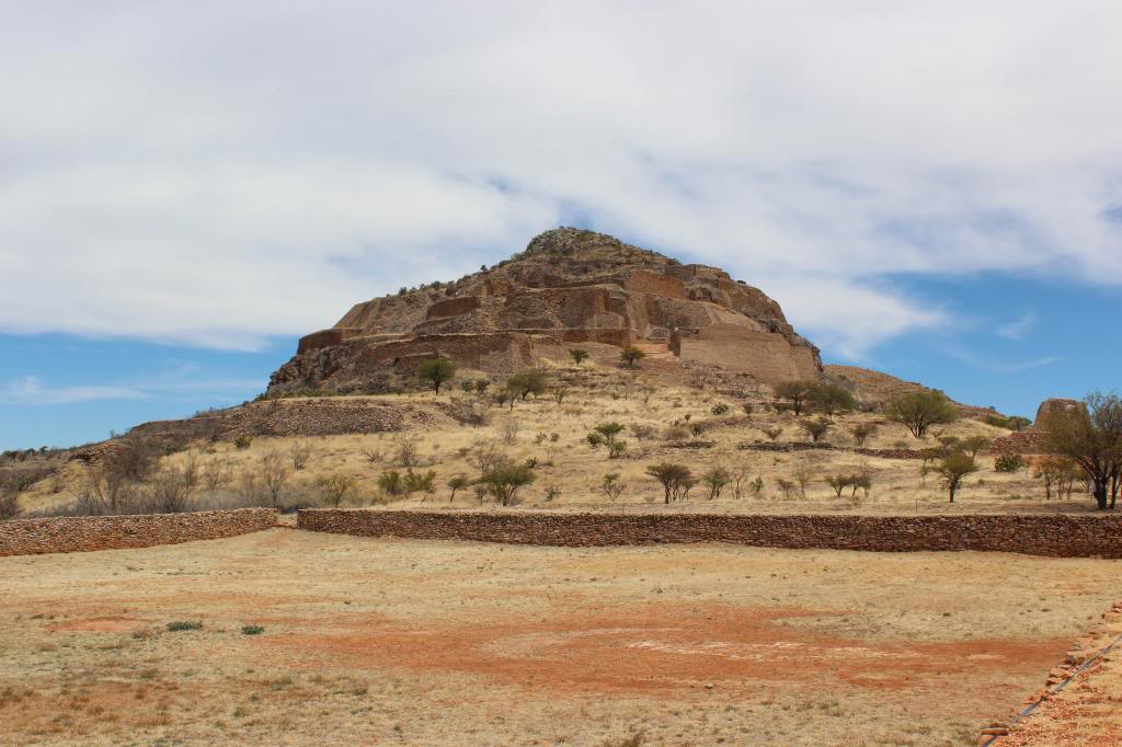
I hope you don't mind but I'm going to upload this pic so everyone can see the scale of this place, it looks like a hilltop fort to me.
You're very lucky to go to such places, I'm jealous
edit on 5-3-2014 by weirdguy because: (no reason given)
Those ruins makes me think of the monastery/cathedral Mont. St. Michel in France.
From the layout of the land in the picture, it looks like there used to be a river estuary there, which would have meant there was a supply of water. One defensive measure was to use wooden blocks as intermediate steps between the larger ones, or maybe there was a wooden staircase and handrail there at the time.
edit on 6-3-2014 by stormcell because: (no reason given)
kix
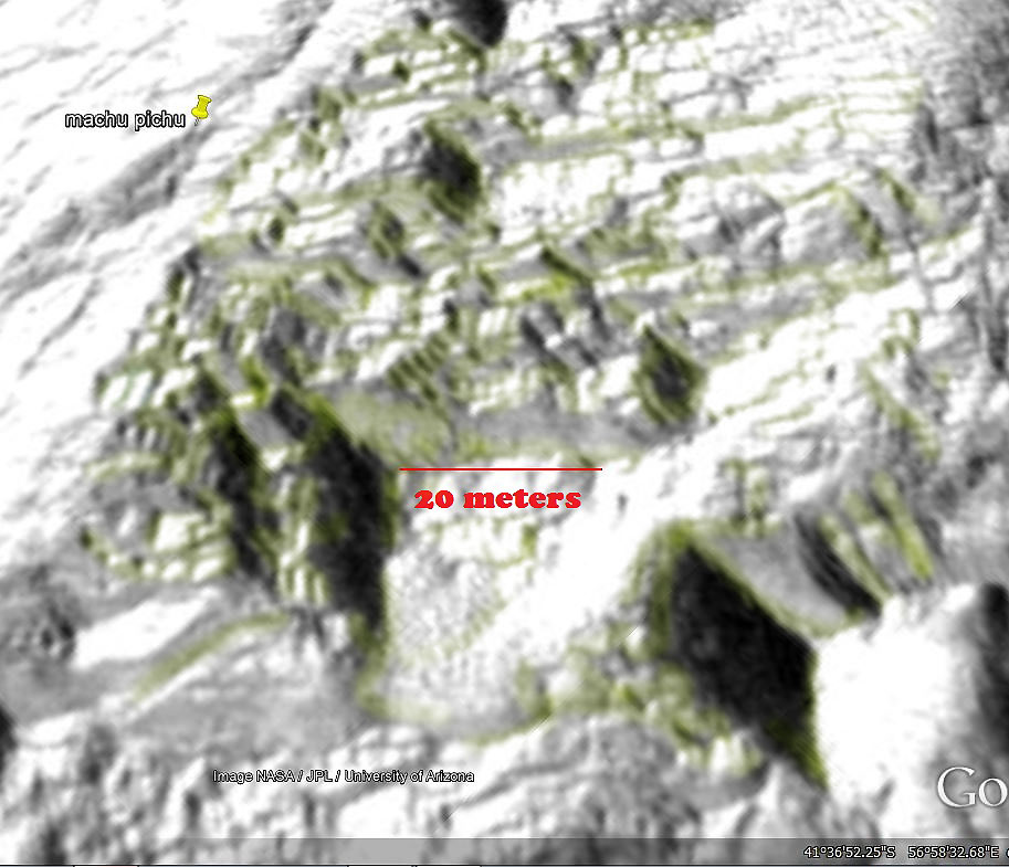
...I wanted to check the image from above... here the PLOT BEGINS...
...
Thanks for the very interesting topic, kix
It is interesting that Google Earth chose to insert the 'blur' at the edge of the site.
The blur is in the form of two rectangles that stretch (en grosse) approximately 10 miles from the Northeast corner to the Southwest corner (on the eastern side, the blur extends only about half the distance to the bottom, or southwestern edge, allowing a fairly clear view of the area designated as El Saucillo).
Most of that 'blur' is mountainous.
Do you know (did they claim to know) where the rock & stone came from...to build the site?
Any obvious quarrying in the vicinity?
Or - does it look to have been taken from the local and surrounding terrain?
How/When were you made aware of this site?
Anyway - S&F - and - Thanks!
Even though I have traveled to a lot of archeological sites in Mexico and quite a few of the weird, off the beaten path, I have never heard of these,
I went to Zacatecas to a Kansas(rock band) concert and while checking what I was going to do I found about Chicomostoc (la Quemada).
Now there is no obvious place for the kind of rocks the place is built from, in fact all that part of the state is filled with metals specially silver, you can see the minerals and the sparkling on a lot of roos all around the place from metallic minerals.
The whole region has been arid for at least 2500 years, after the last glacial age the norther part of Mexico became desert and very arid, lacking important rivers. So the question remains if they inhabited the place from the 400 to the 1000 A.D were the heck they got water from, the whole plateau is quite big and from what they told us it was a huge city and this was the fortified place of entry.... why such size no idea, as what kind of enemies they had,also a riddle at best.
A client of mine says that even more close to the US border there are round pyramids that rival those in the souther part of Mexico... I hope I can travel there this summer... from what I can grasp all (north) archeology in Mexico is seldom explored, not mentioned or more posible even blurred from sat images, to what purpose or end.... thats is the mystery.
SeekingDepth
There are more videos on Youtube all in Spanish here is one (Spanish members maybe translate?)
Here is my translation for the video, hope you find it useful:
0:01
If nature has been lavish in Zacatecas, composing spectacular spaces, the human presence can not be underestimated, an example is the remarkable prehispanic city of La Quemada.
0:16
History goes that in 1615 the monk Juan de Torquemada identified the site as one of the places that were visited by the Aztecs in their migration to the basin of Mexico, were they leave children and the elderly behind.
0:31
In 1780 the historian and religious Clavijero associated this place with Chicomostoc, were the Aztecs stayed for nine years during his travel to the valley of Anahuac, this speculation led to the popular tradition which identifies La Quemada as the mitical place called Las Siete Cuevas (The Seven Caves).
1:02
Calvillo: 2050 years since the first settlers arrived here to the valley of La Quemada.
Alvarado (host): I'm here talking with Mr. Apolinar Calvillo who is a turist guide in La Quemada, he can explain us how many rooms and balconies were made.
Calvillo: There are 50 balconies, we are located in the room of the eleven columns, which belongs to the first level, this room was used for gatherings of the priests that ruled the site for organization of their government.
1:50
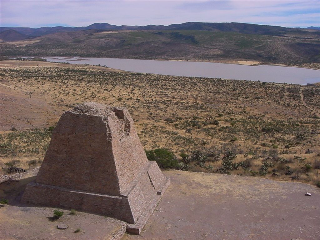
Calvillo: The perimeter of the archaeological zone is 70,500 square meters (he should refer to the area since a perimeter can't be measured in square meters), consist of five levels, the first level includes the room of columns, the ball court and Votiva pyramid. On the second level we have a circular complex, the barracks or labyrinth, and a platform or habitable balcony.
2:43
Calvillo: Third level, we have the open room, some speculate about the possibility of human sacrifices being made here.
2:56
Calvillo: The fourth level is the resting space were they supposedly looked to all the valley below.
3:15
Calvillo: And the fifth level is the astronomical observatory.
3:35
Alvarado: The access is located on the north side of the hill, and definitely a lot of physical strength is needed.
3:56
Calvillo: The Votiva pyramid is an structure that the archaeologists believe that was used for ceremonial and religious rituals, based on the evidences found on the pinnacle, like an small altar made of adobe with grass roof, lithic pottery, bone needles and evidence of textile fibers. Archaeologist also believe that a big statue made of stone was located here before being stolen, that's why for them this is not the pyramid of the sun.
Alvarado: Does it have Aztec characteristics?
Calvillo: Some people say so but the diggings made here didn't show any evidence, we don't have pottery or any other evidence of the Aztec culture, instead it seems like Toltec culture.
5:04
The architectonic design of this impressive place was planned in a way that integrates into the surrounding landscape, were the visitor maintains a true communion with history.
5:39
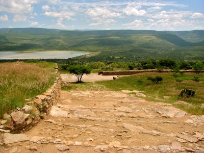
All the Mesoamerican archaeological traces are really impressive in La Quemada, look at this stairway that I have to climb to return and continue with our show Reportajes de Alvarado (Alvarado's Report)
reply to post by kix
Kansas! Cool!
When was that (if I might ask?). Was it before Kerry Livgren left...or...after he returned...or...after he left again?
If you wouldn't mind...I'm not sure I understood one of your answers clearly...
Are you saying that the rocks/stones used in the construction are not native to the area?
As to the 'blurring' - I am convinced that Google Earth uses this "method" of obscuring finds of interest/intrigue, that they hope to capitalize on --- or --- that they use the method, when the party they purchased the rights to display the satellite imagery from...say so. I also wonder if the party/ies they purchase the rights from, might not install the 'blurring' prior to Google Earth acquiring the same.
So - when you say "northern Mexico" - are you talking about Chihuahua or Sonora or...where?
Thanks for the information!
reply to post by kix
My best guess about the water supply is an under ground river system or artesian basin that comes to the surface as a fresh water spring.
My best guess about the water supply is an under ground river system or artesian basin that comes to the surface as a fresh water spring.
Interesting site.
Thx for this. S&f.
I saw something similar elsewhere... but more bigger.
So above so below...
Thx for this. S&f.
I saw something similar elsewhere... but more bigger.
So above so below...
kix
As you can see the road and its parts are very clear but we move to the archeological site and its all blurred !!! WHY ? You can even see the road that lead to the site and its all blurred.. WHY ?
Google Earth uses images from satellite, aircraft and now streetview if they have NOT got a link to an aerial shot taken from an aircraft that may be a reason for the blurred image.
The rise and height of the stair depends on how much space you have. If you have a 20 foot run and a twenty foot rise then your stair heights have to
added up to 20 feet. So if I had 10 stairs treads I would need 2 foot rise to make it to the top.
reply to post by kazike
Thank you much kazike for translating the words of the video!! Learned more much appreciated.
Brings more questions.
I wonder if the Aztecs left their elderly & children behind here when migrating was it due to it being a safe place for them with water & food. Like kix has wondered where did they get their water? I did see a lake in the videos is that a recent manmade lake or has it been there for a long time? I am thinking the same as weirdguy natural spring in the area… Maybe under the lake? Even to build something this massive would have required much water consumption.
This link states that the Malpaso River has been dammed since ancient times & the surrounding area is agriculturally productive.
www.scotttraveler.com...
Just found a link that describes La Quemada as the local “Home Depot” for a thousand years & that the lake formed from the Malpaso River.
cookjmex.blogspot.com...
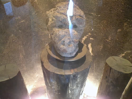
In the 1st video I posted in this thread toward the end as they are in the museum at La Quemada there was a brief glance at a stone head on display. I searched for other pics or information on this find but only found this picture on a Bing image search “Museo de Sitio La Quemada”. No other info.
Thank you much kazike for translating the words of the video!! Learned more much appreciated.
Brings more questions.
I wonder if the Aztecs left their elderly & children behind here when migrating was it due to it being a safe place for them with water & food. Like kix has wondered where did they get their water? I did see a lake in the videos is that a recent manmade lake or has it been there for a long time? I am thinking the same as weirdguy natural spring in the area… Maybe under the lake? Even to build something this massive would have required much water consumption.
This link states that the Malpaso River has been dammed since ancient times & the surrounding area is agriculturally productive.
www.scotttraveler.com...
Just found a link that describes La Quemada as the local “Home Depot” for a thousand years & that the lake formed from the Malpaso River.
cookjmex.blogspot.com...
In the 1st video I posted in this thread toward the end as they are in the museum at La Quemada there was a brief glance at a stone head on display. I searched for other pics or information on this find but only found this picture on a Bing image search “Museo de Sitio La Quemada”. No other info.
Soooo we are hunting the mysteries of La Quemada, one of the many strange places in the world. (like that underwater pyramid eh ? ) So Doesnt it look
like a little like observation post ? Since its build so high up. Like observing Stars ad such.
edit on 7-3-2014 by ZeroFurrbone because: (no
reason given)
edit on 7-3-2014 by ZeroFurrbone because: Do i have to say a reason D:
Is there anyone associated with GOOGLE Maps on ATS that can answer the question of why some remote areas are blured out. As a further example, in
Arizona, areas not remotely associated with the government as all blurred out.
Good question...
Good question...
Folks, folks...let's calm down a tad. Google Maps/Earth may be blurry, but Bing's map site has nice, hi-res images of the location whose quardinants
are: 22°27′23″N 102°49′16″W
Please try other map places other than Google before getting all in a tizzy.
BTW, very nice thread.
Please try other map places other than Google before getting all in a tizzy.
BTW, very nice thread.
As I do every time someone insists that "they" are "hiding our real history from us" I am going to ask...WHY?! What sense on Earth would that
possibly make?! And how could they possibly EVER control what new archaeologists do or do not find, do or do not disclose?! It's just so silly to
think that people are running around hiding dusty old n=bones and buildings from you because...well, I have no idea why they would do it. That's the
problem. It's an impossible task that would make no sense at all.
daveinats
Is there anyone associated with GOOGLE Maps on ATS that can answer the question of why some remote areas are blured out. As a further example, in Arizona, areas not remotely associated with the government as all blurred out.
Good question...
www.abovetopsecret.com...
new topics
-
Thousands Of Young Ukrainian Men Trying To Flee The Country To Avoid Conscription And The War
Other Current Events: 2 hours ago -
12 jurors selected in Trump criminal trial
US Political Madness: 5 hours ago -
Iran launches Retalliation Strike 4.18.24
World War Three: 5 hours ago -
Israeli Missile Strikes in Iran, Explosions in Syria + Iraq
World War Three: 5 hours ago -
George Knapp AMA on DI
Area 51 and other Facilities: 11 hours ago -
Not Aliens but a Nazi Occult Inspired and then Science Rendered Design.
Aliens and UFOs: 11 hours ago
top topics
-
George Knapp AMA on DI
Area 51 and other Facilities: 11 hours ago, 25 flags -
Israeli Missile Strikes in Iran, Explosions in Syria + Iraq
World War Three: 5 hours ago, 14 flags -
Louisiana Lawmakers Seek to Limit Public Access to Government Records
Political Issues: 13 hours ago, 7 flags -
So I saw about 30 UFOs in formation last night.
Aliens and UFOs: 16 hours ago, 6 flags -
Iran launches Retalliation Strike 4.18.24
World War Three: 5 hours ago, 6 flags -
Do we live in a simulation similar to The Matrix 1999?
ATS Skunk Works: 17 hours ago, 5 flags -
Not Aliens but a Nazi Occult Inspired and then Science Rendered Design.
Aliens and UFOs: 11 hours ago, 5 flags -
12 jurors selected in Trump criminal trial
US Political Madness: 5 hours ago, 4 flags -
The Tories may be wiped out after the Election - Serves them Right
Regional Politics: 14 hours ago, 3 flags -
Thousands Of Young Ukrainian Men Trying To Flee The Country To Avoid Conscription And The War
Other Current Events: 2 hours ago, 2 flags
active topics
-
Fossils in Greece Suggest Human Ancestors Evolved in Europe, Not Africa
Origins and Creationism • 60 • : whereislogic -
Scarface does Tiny Desk Concert
Music • 7 • : sitrose -
The Acronym Game .. Pt.3
General Chit Chat • 7727 • : F2d5thCavv2 -
Russia Ukraine Update Thread - part 3
World War Three • 5697 • : F2d5thCavv2 -
Do we live in a simulation similar to The Matrix 1999?
ATS Skunk Works • 22 • : SchrodingersRat -
Iran launches Retalliation Strike 4.18.24
World War Three • 15 • : semperfortis -
President BIDEN Warned IRAN Not to Attack ISRAEL - Iran Responded with a Military Attack on Israel.
World War Three • 43 • : WeMustCare -
Israeli Missile Strikes in Iran, Explosions in Syria + Iraq
World War Three • 52 • : WeMustCare -
Mandela Effect - It Happened to Me!
The Gray Area • 107 • : inflaymes69 -
Terrifying Encounters With The Black Eyed Kids
Paranormal Studies • 45 • : daskakik