It looks like you're using an Ad Blocker.
Please white-list or disable AboveTopSecret.com in your ad-blocking tool.
Thank you.
Some features of ATS will be disabled while you continue to use an ad-blocker.

Pentagon "NTSB animation" is wrong!
page: 1share:
Pentagon no plane hoaxers take heed! The north of the Citgo flight path has yet another problem!
For those who don’t know, the new rage in no-757-strike-at-the-Pentagon is a double-corroborated "proof" that the plane posing as Flight 77 flew at such an angle - north of the Navy Annex and the Citgo gas station - that it COULD NOT have clipped the five light poles or cause the angled building damage attributed to Flight 77. This theory is bracketed on two ends by Citizen Investigative Team (featuring our very own ATS Conspiracy Master "Jack Tripper") and their video The PentaCon (which covers the eyewitness end), and their "brother organization" Pilots for 9/11 Truth (P49T, of which I believe fellow ATS master John Lear is a member), whose video Pandora's Black Box Chapter 2 calls on an "NTSB" flight reconstruction derived directly, we are told, from the Flight Data Recorder (FDR) of flight 77. While the eyewitness end and the FDR (as seen in the animation) disagree wildly on the plane’s altitude, they seem to agree on the damning flight path, and thus seemed well-poised to take down the official story.
The final minutes of this animated NTSB file can be seen here:
For the moment I’ll ignore the CIT witness testimony (I’ve already said my bit over that, and don't have anything to add - yet) and look just at this animation; it contradicts the official story on several points, but what I’m looking at here is the flight path, the direction it was pointed in its final seconds.
The animation has other problems, which I feel a need to address again, including its NTSB authenticity (Paper Trail problems explained) It was supposedly sent to British researcher Calum Douglas (aka "Snowygrouch") after an FOIA request, in July 2006. Some info on this receipt and the difficulties of getting verifying data are recounted in this presentation by Douglas in Ipswich in March. Great viewing, some real WTF X-Files moments, like the (CSV file?) data being clandestinely translated for them by a corporate bigwig on a laptop in a hotel room!
Anyway, as Douglas and the P49T guys will tell, you, it's complicated stuff, and they put a lot of work into understanding how the data and animation fit together. Well, as "Snowygrouch" puts it, it’s not animation, since “animation implies some sort of fictitious content.” So he calls it a reconstruction. I’ll continue to call it an animation.
He'd been analyzing it for over six months before that speech in Ipswich, where he gave no clue that he ever stumbled upon the real problem with his animation I found in twenty minutes once I'd thought of it.
The American Society of Civil Engineers cite from the NTSB a magnetic heading for the plane at impact – 70 degrees from north - which they found consistent enough with the building damage to use it as an explanation of how the building was damaged the way it was. I Checked my jumbled “CSV” file [downloaded from P49T], and found a termination magnetic heading of precisely 70.0 degrees in the last frame of data. Then I looked closer at the animation, and see in the final moments a dial there reading 70, which I take to be the magnetic heading. Thus all FDR sources I can see match, even the animation. Yet one such mapping of that heading matches the official story while the same trajectory, once animated as in this case, is on a path to miss the light poles and rule out the angled building damage.
On further analysis I duly cheesed out. What was 70 degrees from what? How on Earth could I solve this problem? But after cutting my teeth on shadow reading, I decided to try common sense to get to the bottom of this discrepancy and with it the animation’s corroboration of the too-north-path. It wasn't too hard, really. I just checked that my map was oriented north, took that as 0/360 degrees, dropped a compass on it, drew a line at 70 deg and it matched the official flight path, the light pole clippage, and building damage. This is from FDR data downloaded from Pilots for 9/11 Truth, generally said to refute this path. This means we’re in business.
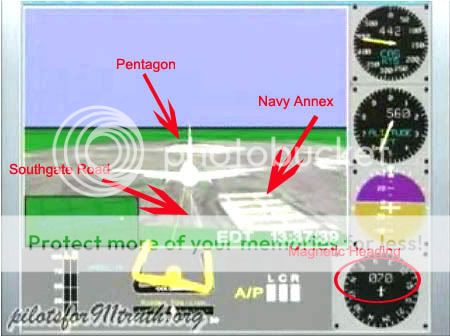
So I looked at how 70 degrees translated into that animation. I capped a frame of the plane passing over the Navy Annex area, nearly centered on what I determined to be Southgate Road (at a mag heading of 70 it says) and mapped that. Lo and behold, the path from there to the Pentagon, the path taken in the video, is NOT a 70 degree heading! It's 80 degrees, a full ten degrees off!
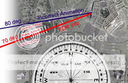
Thus claim that the FDR data shows a northern flight path contradictory with the official story is plain wrong. Actually looking at the data, all we see is 70, 70, 70, even right there on screen in the animation's heading dial. But they don’t zoom in on the number, but on the picture, which, if you map it out, is 80 degrees, not 70. Again, their too-north FDR data case is based on one thing and one thing only – the animation picture – and that is FLAT WRONG.
Can anyone here honestly see another explanation?
It’s still unclear whether the NTSB slapped this together themselves with such poor quality control and high mystery potential, if Calum had it made "based on the data," or if it was slipped to him in some other way so he'd truly believe it. But it's wrong, and as for his apparently not catching this simple-to-find discrepancy, well, that doesn't bode well for his credibility, nor that of the others who've cavorted with this "smoking gun."
[edit on 27-5-2007 by Caustic Logic]
Mod Edit: cap title
[edit on 6/8/2007 by kinglizard]
For those who don’t know, the new rage in no-757-strike-at-the-Pentagon is a double-corroborated "proof" that the plane posing as Flight 77 flew at such an angle - north of the Navy Annex and the Citgo gas station - that it COULD NOT have clipped the five light poles or cause the angled building damage attributed to Flight 77. This theory is bracketed on two ends by Citizen Investigative Team (featuring our very own ATS Conspiracy Master "Jack Tripper") and their video The PentaCon (which covers the eyewitness end), and their "brother organization" Pilots for 9/11 Truth (P49T, of which I believe fellow ATS master John Lear is a member), whose video Pandora's Black Box Chapter 2 calls on an "NTSB" flight reconstruction derived directly, we are told, from the Flight Data Recorder (FDR) of flight 77. While the eyewitness end and the FDR (as seen in the animation) disagree wildly on the plane’s altitude, they seem to agree on the damning flight path, and thus seemed well-poised to take down the official story.
The final minutes of this animated NTSB file can be seen here:
For the moment I’ll ignore the CIT witness testimony (I’ve already said my bit over that, and don't have anything to add - yet) and look just at this animation; it contradicts the official story on several points, but what I’m looking at here is the flight path, the direction it was pointed in its final seconds.
The animation has other problems, which I feel a need to address again, including its NTSB authenticity (Paper Trail problems explained) It was supposedly sent to British researcher Calum Douglas (aka "Snowygrouch") after an FOIA request, in July 2006. Some info on this receipt and the difficulties of getting verifying data are recounted in this presentation by Douglas in Ipswich in March. Great viewing, some real WTF X-Files moments, like the (CSV file?) data being clandestinely translated for them by a corporate bigwig on a laptop in a hotel room!
Anyway, as Douglas and the P49T guys will tell, you, it's complicated stuff, and they put a lot of work into understanding how the data and animation fit together. Well, as "Snowygrouch" puts it, it’s not animation, since “animation implies some sort of fictitious content.” So he calls it a reconstruction. I’ll continue to call it an animation.
He'd been analyzing it for over six months before that speech in Ipswich, where he gave no clue that he ever stumbled upon the real problem with his animation I found in twenty minutes once I'd thought of it.
The American Society of Civil Engineers cite from the NTSB a magnetic heading for the plane at impact – 70 degrees from north - which they found consistent enough with the building damage to use it as an explanation of how the building was damaged the way it was. I Checked my jumbled “CSV” file [downloaded from P49T], and found a termination magnetic heading of precisely 70.0 degrees in the last frame of data. Then I looked closer at the animation, and see in the final moments a dial there reading 70, which I take to be the magnetic heading. Thus all FDR sources I can see match, even the animation. Yet one such mapping of that heading matches the official story while the same trajectory, once animated as in this case, is on a path to miss the light poles and rule out the angled building damage.
On further analysis I duly cheesed out. What was 70 degrees from what? How on Earth could I solve this problem? But after cutting my teeth on shadow reading, I decided to try common sense to get to the bottom of this discrepancy and with it the animation’s corroboration of the too-north-path. It wasn't too hard, really. I just checked that my map was oriented north, took that as 0/360 degrees, dropped a compass on it, drew a line at 70 deg and it matched the official flight path, the light pole clippage, and building damage. This is from FDR data downloaded from Pilots for 9/11 Truth, generally said to refute this path. This means we’re in business.
So I looked at how 70 degrees translated into that animation. I capped a frame of the plane passing over the Navy Annex area, nearly centered on what I determined to be Southgate Road (at a mag heading of 70 it says) and mapped that. Lo and behold, the path from there to the Pentagon, the path taken in the video, is NOT a 70 degree heading! It's 80 degrees, a full ten degrees off!
Thus claim that the FDR data shows a northern flight path contradictory with the official story is plain wrong. Actually looking at the data, all we see is 70, 70, 70, even right there on screen in the animation's heading dial. But they don’t zoom in on the number, but on the picture, which, if you map it out, is 80 degrees, not 70. Again, their too-north FDR data case is based on one thing and one thing only – the animation picture – and that is FLAT WRONG.
Can anyone here honestly see another explanation?
It’s still unclear whether the NTSB slapped this together themselves with such poor quality control and high mystery potential, if Calum had it made "based on the data," or if it was slipped to him in some other way so he'd truly believe it. But it's wrong, and as for his apparently not catching this simple-to-find discrepancy, well, that doesn't bode well for his credibility, nor that of the others who've cavorted with this "smoking gun."
[edit on 27-5-2007 by Caustic Logic]
Mod Edit: cap title
[edit on 6/8/2007 by kinglizard]
Wow. Impressive post
I feel ya brother.
To me it's just another case of intentional disinfo. The truth behind it, irrelevant. This view extended on the Pentagon police stooges elaborate this official piece of eivdence, no matter how flawed. The more flawed the better actually, as this would promote the old "incompetence theory".
From what i was percieving, and could even be evidenced on here at ATS, the Pentagon Conspiracy argument was fading away. These 'official' bits reinvigorated it and took it to the next level.
Danke!
I entered the Pentagon study field late last year, feeling like I'd popped in too late, like everyone had moved on, or dropped the issue as too hopelessly confused and too divisive. Then this, PBB and the 'Con, and I actually felt overwhelmed. I'm still getting a grip on it. I hope it doen't matter much, that I've wasted my time becuase no one much buys this BS. But 20 min plus post creation time is well-worth it to put this up I think. Just in case.
Originally posted by IgnoranceIsntBlisss
From what i was percieving, and could even be evidenced on here at ATS, the Pentagon Conspiracy argument was fading away. These 'official' bits reinvigorated it and took it to the next level.
I entered the Pentagon study field late last year, feeling like I'd popped in too late, like everyone had moved on, or dropped the issue as too hopelessly confused and too divisive. Then this, PBB and the 'Con, and I actually felt overwhelmed. I'm still getting a grip on it. I hope it doen't matter much, that I've wasted my time becuase no one much buys this BS. But 20 min plus post creation time is well-worth it to put this up I think. Just in case.
if i were to be one of the skeptics
you gotta admit they got alot of speed by doing that.
i believe it has something to do with getting the right g's
kinda like sling shotting your self through the air, with all the resistance.
but then again i dont believe that any plane ever hit the pentagon.
and i agree with the precision part, you'd have to be a good piolate for sure.
Originally posted by tribaltrip
if i were to be one of the skeptics
you gotta admit they got alot of speed by doing that.
i believe it has something to do with getting the right g's
kinda like sling shotting your self through the air, with all the resistance.
but then again i dont believe that any plane ever hit the pentagon.
and i agree with the precision part, you'd have to be a good piolate for sure.
Thanks for the thoughts. All points I've heard before, each with its own answer, but not for here.
This precision piloting north of the Annex being ficitious is the point. That and why P49T never caught this seam even I could find. It's this lack of self-debunking and critical thought on the part of CTers that lets crap like this form the basis of our "serious questions." There are tons of questions, why this "NTSB recreation" doesn't match the "official lie" should not be one of them.
Nice work, CL.
Playing devil's advocate for a moment, is it possible that this was caused by the yaw Sgt Lagasse (sp?) spoke of as he described the last seconds of the aircarft's approach?
Playing devil's advocate for a moment, is it possible that this was caused by the yaw Sgt Lagasse (sp?) spoke of as he described the last seconds of the aircarft's approach?
Originally posted by coughymachine
Nice work, CL.
Playing devil's advocate for a moment, is it possible that this was caused by the yaw Sgt Lagasse (sp?) spoke of as he described the last seconds of the aircarft's approach?
Had to look this up:
A yaw motion is a side to side movement of the nose of the aircraft
source
A wobble. Now I know that...
Mmm... it may be related but perhaps not in the way you might be thinking. A yaw is a sublte shift within a general direction - the nose might have a different reading for a moment, but this one is at an iverall 80 degree steady path, and the mag heading dial stays solidly at 70. Watch the last few seconds - a change from 69 to 70 is noted, then all 70 from there. No yaw of even one degree shown, definitely not 10 degrees.
Now this wrong animation does (coincidentally?) match about the same angle Lagasse has always reported. He's another issue - since 2002 he's said the plane flew in that angle, from the north, which has no other substantial support in the witness pool, nor as we see in the FDR data except when that data is animated 10 degrees wrong, as it is here. So whyever exactly he's been wrong this whole time, I wouldn't put too much stock in his account or any sub-detail of it. He may in fact have thrown this in to help confuse the issue, suggesting that maybe the 70 reading is from a momentary yaw of a plane on an 80 traj.
Oh dear, I'm covering for the perps again by attacking the CIT's sterling witnesses... I hadn't meant to go there.
[edit on 27-5-2007 by Caustic Logic]
I think it was being remotely controlled, and the pilot probably had no control whatsoever. Thats my opinion.
Even if it WAS being remote controlled that has no relevance to the flight path being 10 degrees off. If it was being remote controlled and took the
more northern path that people are claiming the heading indicator would STILL show a 080 reading, not the 070 it shows the entire time. It's a
simple compass, not some high tech instrument that you can make show a reading that's different from true.
When you drew the map based on the mag heading from the FDR, did you correct your map for local magnetic variation, and not simply call "True North"
"Magnetic North" for convienience?
If so, great catch!
If so, great catch!
He's not the only one to have found this. I've found another site that found the same thing, with four or five people working on it and being in
agreement. The data from the recorder matches up with what Caustic is saying here.
The magnetic declination at the pentagon is between -10 and -11 degrees.
Pentagon magnetics. NOAA calcs for the lat/long gave -10.7.
Are the readings as recorded corrected for mag declination? Maybe Mr. Lear could clear this up.
[edit on 5/27/2007 by roadgravel]
Pentagon magnetics. NOAA calcs for the lat/long gave -10.7.
Are the readings as recorded corrected for mag declination? Maybe Mr. Lear could clear this up.
[edit on 5/27/2007 by roadgravel]
Originally posted by mirageofdeceit
When you drew the map based on the mag heading from the FDR, did you correct your map for local magnetic variation, and not simply call "True North" "Magnetic North" for convienience?
If so, great catch!
Well, hmm.... I used north. If this is enough to be a problem I will take note.
There is another issue with this heading data. Given the nature of the turn, shouldn't the reading have passed through 80 degrees on its way to 70?
The figure was climbing to 70, not falling. Had the aircraft continued its turn, the reading would have continued to rise towards 80 but the angle
would have become even more at odds with the official 70 degree flightpath.
What's going on there?
What's going on there?
edit: new post below
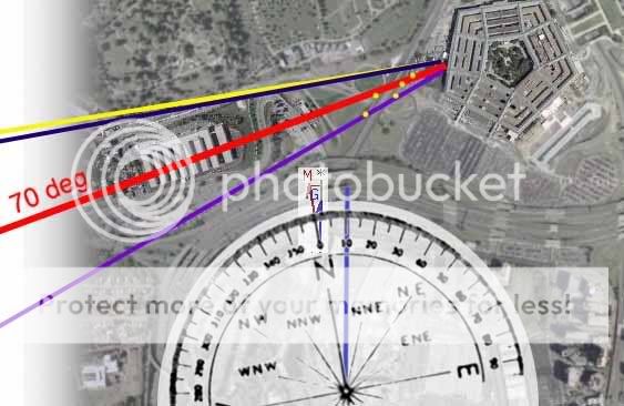
Okay, so magnetic north vs. geographic north, an issue I hadn't thought about at first. But since were looking at magnetic heading, clearly I should have. Thanks Gravelroad for the link - this is based on CURRENT difference - not the diff on 9/11 (magnetic north is constantly shifting I guess). I took my map, rotated the compass back 11 degrees (it said like -10.8 when I looked), re-drew the 70 line, and got the purple one, even further from the animation path. Actually, the official story (lightpoles in yellow) is somewhat between the red and purple, but this could be the roughnness of my graphics. The animation path does not change, and in case I'm correcting backwards, which is just the kind of thing I'd do, I added a yellow line corrected 11 deg the other way, which now matches the animation path.
So 2 questions remain:
1) Does the mag diff of 11 degrees explain the animation path, or make it less feasible yet? I'm in over my head, but it should be simple enough for someone to answer.
2) How does mag diff NOW compare to the diff on 9/11? Looking at the poles I'd venture a guess that it was less than today, perhaps a declination of 5-10 degrees?
[edit on 28-5-2007 by Caustic Logic]
[edit on 28-5-2007 by Caustic Logic]
Yep I know
[edit on 28-5-2007 by Caustic Logic]
[edit on 28-5-2007 by Caustic Logic]
Originally posted by coughymachine
There is another issue with this heading data. Given the nature of the turn, shouldn't the reading have passed through 80 degrees on its way to 70? The figure was climbing to 70, not falling.
??
Had the aircraft continued its turn, the reading would have continued to rise towards 80 but the angle would have become even more at odds with the official 70 degree flightpath.
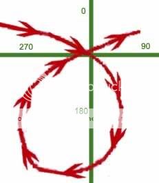
First - The turn was from pointing about 100 deg (basically east) on its way to DC, it turned south - 120, 180 (due S), 270(W), 360/0 (N), then after passing nose due north, the numbers tick up - 0 to 45 (NE) and finally settling on 70 (ENE) for its final stretch. The range of about 70-100 is the only portion of the compass it was not pointing during the turn.
Second - so yes, if it had continued its turn, it would've pointed at 80 degrees and eventuall 90 and so on. To reach the angle in the animation, it would've need to turn further than in the official story, but to wind up at 80 and north of the annex, it'd also need to be a larger loop in general. Mapping out the rate of turn and everything between other FDR data and this animation might prove fruitfull as well, but I don't have that kind of time. Not for this anyway. -
Originally posted by Zaphod58
He's not the only one to have found this. I've found another site that found the same thing, with four or five people working on it and being in agreement. The data from the recorder matches up with what Caustic is saying here.
Thanks for knowing and sharing that. I'm seriously not copying them (or I'd probably be doing better). But I'd like to see what they did and compare. Care to share a link?
Originally posted by neumbows
the video is another case of disinformation imo!
Disinformation: purposeful and strategic misinformation.
The animation:
We know it's info.
We're seeing if it deserves a "mis" prefix
Motives that establish a "mis" as a "dis" are unprovable either way.
It's a matter of opinion. But there's so much dodginess about all of this my best guess is you're right. IMO.
I often enter into a thread to see if it is a proof of conspiracy thread or a debunking of a conspiracy thread.
Im not sure what this thread is about.
In pentacon the theory was the plane flew on the north side of the Citco, which put it at the wrong flight path to hit the light poles.
Are you debunking pentaCon?
Im not sure what this thread is about.
In pentacon the theory was the plane flew on the north side of the Citco, which put it at the wrong flight path to hit the light poles.
Are you debunking pentaCon?
new topics
-
VP's Secret Service agent brawls with other agents at Andrews
Mainstream News: 11 minutes ago -
Sunak spinning the sickness figures
Other Current Events: 52 minutes ago -
Nearly 70% Of Americans Want Talks To End War In Ukraine
Political Issues: 1 hours ago -
Late Night with the Devil - a really good unusual modern horror film.
Movies: 2 hours ago -
Cats Used as Live Bait to Train Ferocious Pitbulls in Illegal NYC Dogfighting
Social Issues and Civil Unrest: 4 hours ago -
The Good News According to Jesus - Episode 1
Religion, Faith, And Theology: 6 hours ago -
HORRIBLE !! Russian Soldier Drinking Own Urine To Survive In Battle
World War Three: 8 hours ago -
Bobiverse
Fantasy & Science Fiction: 11 hours ago -
Florida man's trip overseas ends in shock over $143,000 T-Mobile phone bill
Social Issues and Civil Unrest: 11 hours ago
top topics
-
Florida man's trip overseas ends in shock over $143,000 T-Mobile phone bill
Social Issues and Civil Unrest: 11 hours ago, 8 flags -
SETI chief says US has no evidence for alien technology. 'And we never have'
Aliens and UFOs: 15 hours ago, 7 flags -
Cats Used as Live Bait to Train Ferocious Pitbulls in Illegal NYC Dogfighting
Social Issues and Civil Unrest: 4 hours ago, 7 flags -
This is our Story
General Entertainment: 17 hours ago, 4 flags -
Former Labour minister Frank Field dies aged 81
People: 13 hours ago, 4 flags -
Bobiverse
Fantasy & Science Fiction: 11 hours ago, 3 flags -
HORRIBLE !! Russian Soldier Drinking Own Urine To Survive In Battle
World War Three: 8 hours ago, 2 flags -
Nearly 70% Of Americans Want Talks To End War In Ukraine
Political Issues: 1 hours ago, 2 flags -
Late Night with the Devil - a really good unusual modern horror film.
Movies: 2 hours ago, 2 flags -
VP's Secret Service agent brawls with other agents at Andrews
Mainstream News: 11 minutes ago, 1 flags
active topics
-
Truth Social goes public, be careful not to lose your money
Mainstream News • 126 • : Zanti Misfit -
President BIDEN Vows to Make Americans Pay More Federal Taxes in 2025 - Political Suicide.
2024 Elections • 118 • : DBCowboy -
Nearly 70% Of Americans Want Talks To End War In Ukraine
Political Issues • 6 • : budzprime69 -
VP's Secret Service agent brawls with other agents at Andrews
Mainstream News • 1 • : budzprime69 -
HORRIBLE !! Russian Soldier Drinking Own Urine To Survive In Battle
World War Three • 25 • : Freeborn -
Definitive 9.11 Pentagon EVIDENCE.
9/11 Conspiracies • 422 • : Zanti Misfit -
Breaking Baltimore, ship brings down bridge, mass casualties
Other Current Events • 482 • : IndieA -
How ageing is" immune deficiency"
Medical Issues & Conspiracies • 30 • : annonentity -
Remember These Attacks When President Trump 2.0 Retribution-Justice Commences.
2024 Elections • 55 • : Zanti Misfit -
SETI chief says US has no evidence for alien technology. 'And we never have'
Aliens and UFOs • 36 • : anthelion