It looks like you're using an Ad Blocker.
Please white-list or disable AboveTopSecret.com in your ad-blocking tool.
Thank you.
Some features of ATS will be disabled while you continue to use an ad-blocker.

Flight 77 FDR research
page: 5share:
Originally posted by mirageofdeceit
Hmmm.....
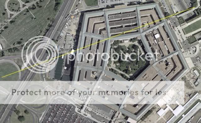
Anything look wrong to you in this pic?
I have never spent much time looking at the Pentagon from overhead but in this picture where the heliport should be are a few buildings and what appears to be construction equipment.
Is this an old picture of the Pentagon or new? I know I should know but I don't. Sorry.
I think 1999 or so for the actual pic.
Where is the grassy area???
[edit on 8-3-2007 by mirageofdeceit]
Where is the grassy area???
[edit on 8-3-2007 by mirageofdeceit]
Originally posted by mirageofdeceit
I quote myself
I note that during this period there are no jumps in the FDR recorded altitude.
This confirms that the FDR is assuming 29.92 in Hg in its recording.
This puts the aircraft too high above the building, as discussed earlier in the thread.
Have another look at the 3 point plot I provided above. The DFRD data I downloaded ends at 13:37:45, which matches the only verifiable NTSB document I've seen (the flight path anlysis PDF which CausticLogic has a link to early on in this thread)
So the last DFDR data we have places the aircraft approximately 6,500 feet from the pentagon at an actual altitude of approx 473 MSl. Remember the presented pressure altitude is correlated to a 29.92 Hg and local pressure that morning was 30.22. I think I read earlier the Pentagon lawn is at approx 35 ft MSL.
So I dont think we can say the aircraft was too high to hit any light poles or the pentagon. I haven't seen any data from those positions. If anyone has NAV data north east of 38.86293N 77.0773W, please let me know.
I do agree however that hitting the Pentagon would have taken some good, or very lucky flying.
473 MSL. Remember the presented pressure altitude is correlated to a 29.92
The pressure correction is +300 ft for 30.22 in Hg, putting the aircraft at 773 ft MSL.
I think I read earlier the Pentagon lawn is at approx 35 ft MSL
The aircraft is 748 ft above the lawn.
[edit on 8-3-2007 by mirageofdeceit]
Originally posted by mirageofdeceit
The pressure correction is +300 ft for 30.22 in Hg, putting the aircraft at 773 ft MSL.
The DFDR says last pressure altitude is 173 @ 29.92, thats why I stated 473 msl (I added the 300 feet)
The aircraft is 748 ft above the lawn.
[edit on 8-3-2007 by mirageofdeceit]
We don't know that. We don't have any data from coordinates any closer than 6,500 ft SW of the pentagon. At least I don't. Do you?
The aircraft this data applies to was still decending when the last data frame was captured.
There is a great dicrepancy between the plot of the final few seconds of AA77 created by P4911T, and the one I've mapped using the DFDR data from the
L3 .csv files allegedly provided to P4911T from the NTSB.
First the Pilots for Truth plot:
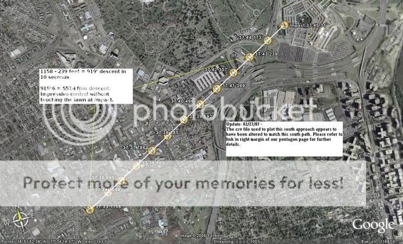
Now mine from the raw data:

Important to note the last data from the DFRD is for a position 1.1 miles from the pentagon. Where is the rest of the data? My understanding that its common that the last 2 seconds prior to a violent crash to be unreadable, but AA77 is still 7-8 seconds from the Pentagon at the last data set.
Now this graph (with no vertical exageration shows the flight profile). P4911T comment on how unlikely this descent is. This descent doesn't seem that unbelievable to me.
I will ask Jack Tripper if he can get P4911T to clarify the difference in the flight path plots. I think they may have simply moved the plot to the NE approximately 1 mile so it terminated at the Pentagon.
If this is what they did, I can understand their argument that the data shows the airplane too high to hit the poles or building, but the altitudes we're talking about actually occured well to the SW (1.1 mile) of the Pentagon. Thats where the last bit of FDR data ends.
It is suspicious that so many seconds (8) are missing rather that the normal 2 seconds
[edit on 3/8/2007 by darkbluesky]
[edit on 3/8/2007 by darkbluesky]
First the Pilots for Truth plot:
Now mine from the raw data:
Important to note the last data from the DFRD is for a position 1.1 miles from the pentagon. Where is the rest of the data? My understanding that its common that the last 2 seconds prior to a violent crash to be unreadable, but AA77 is still 7-8 seconds from the Pentagon at the last data set.
Now this graph (with no vertical exageration shows the flight profile). P4911T comment on how unlikely this descent is. This descent doesn't seem that unbelievable to me.
I will ask Jack Tripper if he can get P4911T to clarify the difference in the flight path plots. I think they may have simply moved the plot to the NE approximately 1 mile so it terminated at the Pentagon.
If this is what they did, I can understand their argument that the data shows the airplane too high to hit the poles or building, but the altitudes we're talking about actually occured well to the SW (1.1 mile) of the Pentagon. Thats where the last bit of FDR data ends.
It is suspicious that so many seconds (8) are missing rather that the normal 2 seconds
[edit on 3/8/2007 by darkbluesky]
[edit on 3/8/2007 by darkbluesky]
For some reason I'm suffering data overload and it just isn't going in!
My apologies on the altitude - I understand what you are saying now.
Simply put, a descent rate of 5,500 ft/min is not impossible, and wouldn't harm the aircraft at all. They haven't seen an emergency descent from altitude before, obviously.
Regarding the data itself; I seem to be missing a whole bunch of data. I don't have positions (Lat/Lon) in my CSV file, and it only goes across to column IV (OpenOffice Calc).
If the data really terminates 8 seconds (or 1.1 nm) from the Pentagon, which terminates at 09:37:44 in my CSV file at least, then this is most definitely fabricated data. At 09:37:44 EICAS COMPUTER goes from OPER to INOP. I have blanks for 09:37:45 and 09:37:46 respectively. In the CSV file, the last two times occur on consecutive rows, no gaps.
I don't have positional data.
The last 1 minute of data (starting at 09:36:44) starts at 3,200 ft when the aircraft is in a rapid descent, and ends at 09:37:44 at 173 ft.
Does this tally with your data?
I don't know about anyone else, but I need a re-cap about what we've found. These are some packed pages!
[edit on 8-3-2007 by mirageofdeceit]
I didnt get a chance to read this whole thread... and i had a full post written up but lost it by hitting backspace.. (ugh! went to last page instead
of backing up cursor).
So here it goes again...
The FDR recorded 1.5 DME off DCA VOR. Based on speed, that brings the aircraft to within 2 seconds on the pentagon wall. There is NO WAY the data stopped 8 seconds out (it would be impossible to record 1.5 DME).
So, using that large margin for error of 2 seconds.. Here is the analysis based on the radar altimeter.
z9.invisionfree.com...
According to the Data Frame Layout, the FDR records Radar altitude before VOR/DME within that frame (1 second).
The NTSB reports 'impact time' at 09:37:45. The csv file and animation has last recorded altitude at 09:37:44 as seen on our pentagon page directly above highway 27 and the light poles...
pilotsfor911truth.org...
The csv file shows 1.5 DME off DCA VOR at 09:37:43. Using slant range, it brings that point directly north of the Citgo Gas Station as cooborated by two Pentagon Police Officers and a gas station worker in ThePentaCon.
The professionals at the NTSB used their sophisticated equipment to plot the flight path starting from taxi out at Dulles to end of recording bringing the aircraft directly over Highway 27.
You can see full analysis here...
z9.invisionfree.com...
If you back that up 8 seconds (as suggested by the above poster), you have to back up that whole path and you will show the aircraft stationary on the runway while the instruments show it flying.
The FDR Expert who decoded the raw file for us said it is not uncommon to see lat/long show discrepencies such as seen above when the aircraft is operating outside the aircraft envelope. It is possible the INS 'crashed' as the aircraft exceeded Vmo.
However, it did record 1.5 DME from DCA VOR, so there is NO WAY the data stopped 8 seconds out as suggested by the lat/long. Govt loyalists try to use this argument because they are grasping at straws. Omit/distract/confuse is a common tactic used.
I was asked to come here to address this issue. I rarely come here, so if anyone would like to debate these issues on a recorded call (as we can cover ALOT more ground in less time), please feel free to contact me at [email protected] to work out the details.
Dont let the govt laylists spin it up. Hold their feet to the fire for a real debate if they are going to try and analyze (read: spin) this information.
Rob Balsamo
Co-Founder
pilotsfor911truth.org
So, what are you saying? The data doesn't add up, or it does? I really am struggling with this...
[edit on 8-3-2007 by mirageofdeceit]
[edit on 8-3-2007 by mirageofdeceit]
The data supplied by the NTSB is in direct conflict with the govt story of American Airlines Flight 77 impacting the pentagon and the light poles on
Highway 27.
We have tried to get the NTSB and FBI to explain these conflicts and/or fix their errors as any respectable report should do, they refuse thus far (hint: they cannot fix any 'errors', as if they fix one, it dominos into other parameters). The NTSB Animation/information all cross-checks the way it is now... unfortunately, the way it is now, does not match the govt story.
Watch the film in the above link for more information.
Hope this helps..
Yeah - thanks!!
I think I need to better acquaint myself with the official story regarding Flight 77.
[edit on 8-3-2007 by mirageofdeceit]
I think I need to better acquaint myself with the official story regarding Flight 77.
[edit on 8-3-2007 by mirageofdeceit]
1) "You have voted darkbluesky for the Way Above Top Secret award. You have used all of your votes for this month." Excellent work. I'm in awe. At
the very least that's south of the Citgo.
2)
Strange that with more research this is getting more confusing...
Thank you for popping in Mr. X/Mr. B. I looked over your data quickly, and it looks like the radar, actual altitude is 273 feet at impact time, no need to correct, and so far above the bldg. correct? I was wondering which doc you got this from: the extras are, I believe, two in number, Tabular CSV, and the L3 file.
Dark Blue, not necc. a Govt loyalist, was just noting above that the data points on the L3 file end at the right time but even further out than your animation shows - by speed eight seconds away, placed there by lat/long readings, which you say someone says can get screwed up. Yet that wasn't mentioned (or was it?) when you used the animation (based on lat/long readings?) to place the plane north of the Citgo in your video? Now that it's south again, the numbers can get screwy, but in a predictable way, placing it in fact over a mile off both to the south and west. This is explained by DME? I'm guessing that's something Margin of Error?
I'm trying to follow all this.
[edit on 8-3-2007 by Caustic Logic]
2)
Me too a ays back tho. That's why I've only been in and out.
Originally posted by mirageofdeceit For some reason I'm suffering data overload and it just isn't going in!
I'm not an official story supporter, but all my analysis up to now points to this, so it's a decent starting point. frustratingfraud.blogspot.com... terlist.html
Originally posted by mirageofdeceit
I think I need to better acquaint myself with the official story regarding Flight 77.
Strange that with more research this is getting more confusing...
Thank you for popping in Mr. X/Mr. B. I looked over your data quickly, and it looks like the radar, actual altitude is 273 feet at impact time, no need to correct, and so far above the bldg. correct? I was wondering which doc you got this from: the extras are, I believe, two in number, Tabular CSV, and the L3 file.
????? Never mind unless important...
If you back that up 8 seconds (as suggested by the above poster), you have to back up that whole path and you will show the aircraft stationary on the runway while the instruments show it flying.
The FDR Expert who decoded the raw file for us said it is not uncommon to see lat/long show discrepencies such as seen above when the aircraft is operating outside the aircraft envelope. It is possible the INS 'crashed' as the aircraft exceeded Vmo.
However, it did record 1.5 DME from DCA VOR, so there is NO WAY the data stopped 8 seconds out as suggested by the lat/long. Govt loyalists try to use this argument because they are grasping at straws. Omit/distract/confuse is a common tactic used.
Dark Blue, not necc. a Govt loyalist, was just noting above that the data points on the L3 file end at the right time but even further out than your animation shows - by speed eight seconds away, placed there by lat/long readings, which you say someone says can get screwed up. Yet that wasn't mentioned (or was it?) when you used the animation (based on lat/long readings?) to place the plane north of the Citgo in your video? Now that it's south again, the numbers can get screwy, but in a predictable way, placing it in fact over a mile off both to the south and west. This is explained by DME? I'm guessing that's something Margin of Error?
I'm trying to follow all this.
[edit on 8-3-2007 by Caustic Logic]
Originally posted by johndoex
The FDR recorded 1.5 DME off DCA VOR. Based on speed, that brings the aircraft to within 2 seconds on the pentagon wall. There is NO WAY the data stopped 8 seconds out (it would be impossible to record 1.5 DME).
I didn't state that it stopped recording 8 second before impact, I noted there was no data provided for the last 8 seconds, assuming the NAV data was correct, and I wonder what happened to the data. As I uderstand it, you attribute this to inaccuracies in lat/long measurement.
Here is the DCA VOR dome:
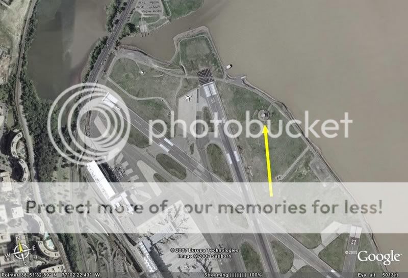
Here is a 1.5 nautical mile radius from DCA VOR:
According to the Data Frame Layout, the FDR records Radar altitude before VOR/DME within that frame (1 second).
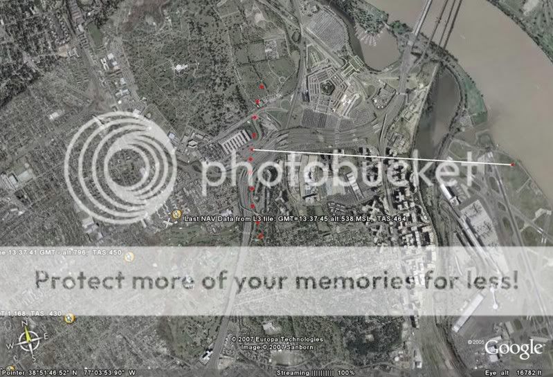
So if I understand, the only real evidence regarding where AA 77 flew, is recorded digital data from the FDR that places the last known position of the aircraft somehwere on the arc of red dots, at a radar altitude (agl) of
approximately 273 at some point within 1 second to the left of the arc?
The csv file shows 1.5 DME off DCA VOR at 09:37:43. Using slant range, it brings that point directly north of the Citgo Gas Station as cooborated by two Pentagon Police Officers and a gas station worker in ThePentaCon.
Or it places it over I-395 directly south of the Navy Annex at 273 AGL.
The FDR Expert who decoded the raw file for us said it is not uncommon to see lat/long show discrepencies such as seen above when the aircraft is operating outside the aircraft envelope. It is possible the INS 'crashed' as the aircraft exceeded Vmo.
Very convenient for those who want a conspiracy. The only hard evidence that can show where the airplane was, and when it was there, can be dismissed according to your FDR expert.
However, it did record 1.5 DME from DCA VOR, so there is NO WAY the data stopped 8 seconds out as suggested by the lat/long. Govt loyalists try to use this argument because they are grasping at straws. Omit/distract/confuse is a common tactic used.
Again, I didn't say the data stopped, I questioned why it was missing.
Regardless of our diferences of opinion, thank you for repsonding to my questions.
The distance you show above is direct line distance over the ground. You have to account for Slant range. If unsure what that is, do a google search
for slant range+DME.
When you account for slant range off DCA VOR at 1.5 DME combined with the fact that it is shown at 09:37:43 in the csv file, it brings you directly north of the citgo station as coorborated by Pentagon Police officers and the gas station worker. Calculations based on speed 2 seconds from impact as noted by the NTSB of 09:37:45.
If it were shown at 09:37:42, it could be argued it was recorded on the south side. But that is not the case.
Dont blame us that it fits any type of 'conspiracy'. Blame the NTSB. Perhaps you should try to do what we are doing in trying to get the NTSB/FBI to either correct their data (they cant as noted above), or explain it.
Or perhaps you can continue to cherry pick and make excuses for it to suit your theory.
And no, we dont claim that 273 AGL was recorded at that time. Matter of fact, 273 AGL shows being recorded at 09:37:47, 2 seconds after supposed impact.
We combine the 273AGL at 2 seconds PRIOR to impact to show that the govt loyalist argument of '2 seconds' missing also does not fit into the govt theory...
Cheers!
Rob
edits: typos are bad today.
[edit on 9-3-2007 by johndoex]
[edit on 9-3-2007 by johndoex]
[edit on 9-3-2007 by johndoex]
OK, so we agree on the 1.5 nm DCA DME, but what of the ghost 3.2 nm DME? The next closest (known) DME is 10 nm away. It isn't even a secret DME at
the Whitehouse as that is too close at 2.3 nm.
[edit on 9-3-2007 by mirageofdeceit]
[edit on 9-3-2007 by mirageofdeceit]
Originally posted by mirageofdeceit
OK, so we agree on the 1.5 nm DCA DME, but what of the ghost 3.2 nm DME? The next closest (known) DME is 10 nm away. It isn't even a secret DME at the Whitehouse as that is too close at 2.3 nm.
[edit on 9-3-2007 by mirageofdeceit]
3.2 DME is off of Armel VOR IIRC. However it wasnt updated. The DME updates once every four seconds.
The 1.5 DME was recorded as the first update so therefore it is much more accurate.
Originally posted by johndoex
The distance you show above is direct line distance over the ground. You have to account for Slant range. If unsure what that is, do a google search for slant range+DME.
Due to the low altitude of the aircraft (approx 300 ft) there is no significant difference between straight range and slant range in this instance. Five feet to be precise. I didnt even need to Google it, I can do trigonometery
When you account for slant range off DCA VOR at 1.5 DME combined with the fact that it is shown at 09:37:43 in the csv file, it brings you directly north of the citgo station as coorborated by Pentagon Police officers and the gas station worker. Calculationsd based on speed 2 seconds from impact as noted by the NTSB of 09:37:45.
As I already said the data could place the aircraft where you say or over I 395 as I say. I guess since you have the "witnesses" you win.
If it were shown at 09:37:42, it could be argued it was recorded on the south side. But that is not the case.
I don't follow your reasoning here. N or S of Citgo the airplane is still 2 secons from the pentagon at the same time its 1.5 NM from DCA VOR and at the same time its roughly 273 ft agl.
Or perhaps you can continue to cherry pick and make excuses for it to suit your theory
And no, we dont claim that 273 AGL was recorded at that time. Matter of fact, 273 AGL shows being recorded at 09:37:47, 2 seconds after supposed impact.
You must have some magic data or be looking at diferent data than that which you provide links to on your forum. My data (tabular and L3) ends at 13:37:45.
Thanks again for your response.
Due to the low altitude of the aircraft (approx 300 ft) there is no significant difference between straight range and slant range in this instance. Five feet to be precise. I didnt even need to Google it, I can do trigonometery
The Slant range is more than that. I did the trig as well. Its somewhere around 8900 feet when using MSL height as shown in the csv file for the time recorded. (if you're gonna do the trig, use the proper numbers that the NTSB supplied for that time.. dont mix and match.. remember to correct for local pressure of 30.22 when using MSL height and to subtract ground elevation of VOR height)
As I already said the data could place the aircraft where you say or over I 395 as I say. I guess since you have the "witnesses" you win.
Wrong, using the proper data as supplied by the NTSB and the relative time stamp, the slant range brings it to the north side at 09:37:43. South side at 09:37:42. The 1.5 DME is shown in the csv file at 09:37:43. But if you want to make excuses for that, fine with us.. we want the NTSB to explain it.
I don't follow your reasoning here. N or S of Citgo the airplane is still 2 secons from the pentagon at the same time its 1.5 NM from DCA VOR and at the same time its roughly 273 ft agl.
explained above
You must have some magic data or be looking at diferent data than that which you provide links to on your forum. My data (tabular and L3) ends at 13:37:45.
Wrong, the 273 was recorded at the 3rd ':45'. The capts clock as shown in the L3 file updates also every 4 seconds. That is why you see the seconds repeat 4 times before updating to the next second.
Thanks again for your response.
You're welcome.
Again, i dont spend much time on ATS, and it appears Darkblue is already pretty confused with this information. So if you would like for me to explain it all to you, please email me as typing up these posts takes up alot of my time and we can cover ALOT more ground on a phone call.
Also, you dont have to take our "FDR Expert" word regarding the lat/long. Call up any company you wish and speak to one regarding INS accuracy outside aircraft envelope.
Cheers!
Rob
typos again..
[edit on 9-3-2007 by johndoex]
new topics
-
God's Righteousness is Greater than Our Wrath
Religion, Faith, And Theology: 1 hours ago -
Electrical tricks for saving money
Education and Media: 4 hours ago -
VP's Secret Service agent brawls with other agents at Andrews
Mainstream News: 5 hours ago -
Sunak spinning the sickness figures
Other Current Events: 6 hours ago -
Nearly 70% Of Americans Want Talks To End War In Ukraine
Political Issues: 6 hours ago -
Late Night with the Devil - a really good unusual modern horror film.
Movies: 8 hours ago -
Cats Used as Live Bait to Train Ferocious Pitbulls in Illegal NYC Dogfighting
Social Issues and Civil Unrest: 9 hours ago -
The Good News According to Jesus - Episode 1
Religion, Faith, And Theology: 11 hours ago
top topics
-
Florida man's trip overseas ends in shock over $143,000 T-Mobile phone bill
Social Issues and Civil Unrest: 16 hours ago, 8 flags -
Cats Used as Live Bait to Train Ferocious Pitbulls in Illegal NYC Dogfighting
Social Issues and Civil Unrest: 9 hours ago, 8 flags -
VP's Secret Service agent brawls with other agents at Andrews
Mainstream News: 5 hours ago, 8 flags -
Bobiverse
Fantasy & Science Fiction: 16 hours ago, 3 flags -
HORRIBLE !! Russian Soldier Drinking Own Urine To Survive In Battle
World War Three: 13 hours ago, 3 flags -
Electrical tricks for saving money
Education and Media: 4 hours ago, 3 flags -
Nearly 70% Of Americans Want Talks To End War In Ukraine
Political Issues: 6 hours ago, 3 flags -
Sunak spinning the sickness figures
Other Current Events: 6 hours ago, 3 flags -
Late Night with the Devil - a really good unusual modern horror film.
Movies: 8 hours ago, 2 flags -
The Good News According to Jesus - Episode 1
Religion, Faith, And Theology: 11 hours ago, 1 flags
active topics
-
VP's Secret Service agent brawls with other agents at Andrews
Mainstream News • 36 • : SchrodingersRat -
The Acronym Game .. Pt.3
General Chit Chat • 7744 • : bally001 -
Truth Social goes public, be careful not to lose your money
Mainstream News • 128 • : Astyanax -
New whistleblower Jason Sands speaks on Twitter Spaces last night.
Aliens and UFOs • 53 • : pianopraze -
Sunak spinning the sickness figures
Other Current Events • 5 • : glen200376 -
SETI chief says US has no evidence for alien technology. 'And we never have'
Aliens and UFOs • 44 • : MikeDeGrasseTyson -
HORRIBLE !! Russian Soldier Drinking Own Urine To Survive In Battle
World War Three • 31 • : budzprime69 -
How ageing is" immune deficiency"
Medical Issues & Conspiracies • 33 • : rickymouse -
The Reality of the Laser
Military Projects • 46 • : Zaphod58 -
God's Righteousness is Greater than Our Wrath
Religion, Faith, And Theology • 0 • : randomuser2034