It looks like you're using an Ad Blocker.
Please white-list or disable AboveTopSecret.com in your ad-blocking tool.
Thank you.
Some features of ATS will be disabled while you continue to use an ad-blocker.

The Mysterious Underground Chambers of Gilmerton Cove
page: 4share:
reply to post by bluemooone2
Rosslyn Chapel was built in 1446, so the story could start long before Isaac Newton! I'm wondering if it's been home to many groups over the centuries.
But I'm open to all theories!!
Rosslyn Chapel was built in 1446, so the story could start long before Isaac Newton! I'm wondering if it's been home to many groups over the centuries.
But I'm open to all theories!!
reply to post by beansidhe
I'm reminded of the fact that the limestone tunnels and caverns within the Rock of Gibraltar were excavated easily by the British military, using ordinary spades, pickaxes etc because the interior of the rock was soft and only became hard when exposed to air. Similarly, some sandstones can be quite loosely agglomerated and can be carved with pen knives. Rock houses at Kinver and Bridgnorth in England were excavated and inhabited for years by people who had nothing but ordinary tools. Whilst I do not know the geology of the Gilmerton Cove area, if sandstone or limestone are present then the excavations are well wiihin ordinary capabilities.
I'm reminded of the fact that the limestone tunnels and caverns within the Rock of Gibraltar were excavated easily by the British military, using ordinary spades, pickaxes etc because the interior of the rock was soft and only became hard when exposed to air. Similarly, some sandstones can be quite loosely agglomerated and can be carved with pen knives. Rock houses at Kinver and Bridgnorth in England were excavated and inhabited for years by people who had nothing but ordinary tools. Whilst I do not know the geology of the Gilmerton Cove area, if sandstone or limestone are present then the excavations are well wiihin ordinary capabilities.
Fantastic stuff... The city of Nottingham is riddled with these sort of cave like structures and a team of surveyors have actually started documenting
them with a virtual mapping system.
Nottingham caves survey
Nottingham caves survey
edit on 19-2-2014 by zeevar because: youtube link
reply to post by zeevar
Wow zeevar, that is really exciting! Have there been any conclusions about their function or their age?
Wow zeevar, that is really exciting! Have there been any conclusions about their function or their age?
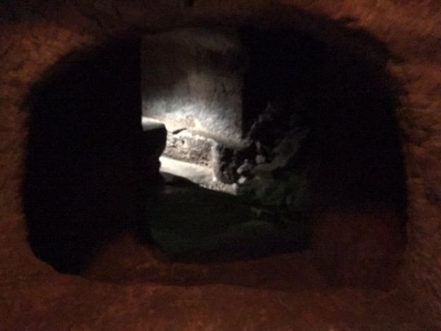
An update on the tunnels was on the news today; it is now thought that they stretch to almost double the size as originally supposed. More chambers,
as yet unexplored, have also been discovered.
BBC Scotland
This is a really exciting development and hopefully we will hear more soon. Personally, I'm hoping that the tunnels lead to Rosslyn Chapel and that they have many more secrets to deliver.
B x
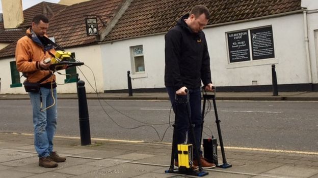
Now scientists from the universities of St Andrews and Edinburgh are using ground-penetrating radar equipment to map out what else may lie beneath. The waves bounce off cavities or tunnels carved into the rock below.
The team has discovered that the subterranean network is at least double the size originally thought. Simon Shackley, from Edinburgh University's School of Geosciences, said: "On the other side of Gilmerton Road there is a rather large chamber that is probably about 4m [13ft] deep."
"There also appear to be cavities in front of the cove and behind it - both about 2m deep".
BBC Scotland
Dr Richard Bates, of St Andrews University, told BBC Scotland the tunnels were "strange places" with very little detail about who used them or why they were built in the first place.
"Perhaps by the work we're doing - if we're getting a bigger picture we're mapping in a more extensive way the footprint of it - then what we're hoping is that will tell us something about the use," he said.
"If it's got lots more passageways or maybe it's only got these two single passageways, but they might be leading somewhere else. And where they're leading to could potentially tell us what these were used for."
This is a really exciting development and hopefully we will hear more soon. Personally, I'm hoping that the tunnels lead to Rosslyn Chapel and that they have many more secrets to deliver.
B x
Oh great this will surely give more bs to be exploited by the curse of oak island show, lol
I can see it now:
What if the tunnels contain a rock in a weird shape ? And the masonic connections?
could these caverns contain the secret to oak island?
Could the tunnels connect to oak island?
Or even worse they will come up with the curse of the Edinburgh tunnel?
Jk aside cant wait till the get more info on this.
new topics
-
A man of the people
Diseases and Pandemics: 24 minutes ago -
Ramblings on DNA, blood, and Spirit.
Philosophy and Metaphysics: 47 minutes ago -
4 plans of US elites to defeat Russia
New World Order: 2 hours ago -
Thousands Of Young Ukrainian Men Trying To Flee The Country To Avoid Conscription And The War
Other Current Events: 5 hours ago -
12 jurors selected in Trump criminal trial
US Political Madness: 8 hours ago -
Iran launches Retalliation Strike 4.18.24
World War Three: 8 hours ago -
Israeli Missile Strikes in Iran, Explosions in Syria + Iraq
World War Three: 9 hours ago
top topics
-
George Knapp AMA on DI
Area 51 and other Facilities: 14 hours ago, 25 flags -
Israeli Missile Strikes in Iran, Explosions in Syria + Iraq
World War Three: 9 hours ago, 16 flags -
Louisiana Lawmakers Seek to Limit Public Access to Government Records
Political Issues: 17 hours ago, 7 flags -
Iran launches Retalliation Strike 4.18.24
World War Three: 8 hours ago, 6 flags -
Not Aliens but a Nazi Occult Inspired and then Science Rendered Design.
Aliens and UFOs: 14 hours ago, 5 flags -
Thousands Of Young Ukrainian Men Trying To Flee The Country To Avoid Conscription And The War
Other Current Events: 5 hours ago, 4 flags -
12 jurors selected in Trump criminal trial
US Political Madness: 8 hours ago, 4 flags -
4 plans of US elites to defeat Russia
New World Order: 2 hours ago, 2 flags -
Ramblings on DNA, blood, and Spirit.
Philosophy and Metaphysics: 47 minutes ago, 1 flags -
A man of the people
Diseases and Pandemics: 24 minutes ago, 0 flags
active topics
-
4 plans of US elites to defeat Russia
New World Order • 8 • : Lazy88 -
Mandela Effect - It Happened to Me!
The Gray Area • 111 • : CCoburn -
So I saw about 30 UFOs in formation last night.
Aliens and UFOs • 31 • : Encia22 -
AARO/Dr Kirkpatrick-Caught Lying in UAP report.
Aliens and UFOs • 25 • : Jukiodone -
Russia Flooding
Fragile Earth • 17 • : Kurokage -
A man of the people
Diseases and Pandemics • 0 • : PrivateAngel -
The Acronym Game .. Pt.3
General Chit Chat • 7729 • : CCoburn -
It has begun... Iran begins attack on Israel, launches tons of drones towards the country
World War Three • 889 • : bally001 -
12 jurors selected in Trump criminal trial
US Political Madness • 23 • : gspatfound -
Ramblings on DNA, blood, and Spirit.
Philosophy and Metaphysics • 0 • : BrotherKinsMan