It looks like you're using an Ad Blocker.
Please white-list or disable AboveTopSecret.com in your ad-blocking tool.
Thank you.
Some features of ATS will be disabled while you continue to use an ad-blocker.

Southern Cyclone/Typhoon Watch 2014
page: 2share:
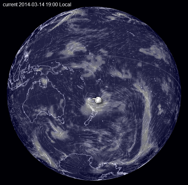
and another one at the same time, coming to NZ?
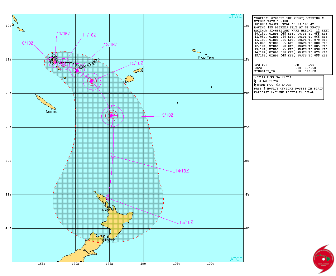
JOINT TYPHOON WRNCEN PEARL HARBOR
REMARKS:
102100Z POSITION NEAR 15.3S 166.5E.
TROPICAL CYCLONE (TC) 18P (LUSI), located approximately 408 nm
north of Noumea, New Caledonia, has tracked south-southeastward
at 02 knots over the past six hours.
TC 18p is currently located within a weak steering environment between a break of two near equatorial ridges (ner) to the northeast and northwest. TC LUSI is expected to stay in this poor steering environment for the next 24 hours before the ner located to the northeast moves to the west and begins to accelerate the system southeastward through tau 48. After
tau 48, a subtropical ridge is expected to amplify to the east of the system and drive tc 18p poleward through the remainder of the forecast. Steady intensification is expected through tau 72 as the favorable upper-level environment and warm sea surface temperatures persist. After tau 72, increasing vws from an approaching mid-latitude trough and decreasing ocean heat content will start a weakening trend. These factors will also induce extra-tropical transition at tau 96 with completion expected by tau 120. Maximum significant wave height at 101800z is 12 feet.
Next warnings at 110900z and 112100z.
www.usno.navy.mil...
and a 3rd one!!??
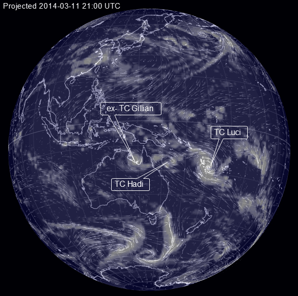
this one is now an ex-TC
Australian Government Bureau of Meteorology
Northern Territory
Tropical Cyclone Warning Centre
Media: The Standard Emergency Warning Signal should NOT be used with this
warning.
PRIORITY
TROPICAL CYCLONE WATCH
TROPICAL CYCLONE ADVICE NUMBER 26
Issued at 5:03 am CST [5:33 am EST] on Tuesday 11 March 2014
A Cyclone WATCH continues for a developing tropical low for coastal areas from Port McArthur to Burketown, including Mornington Island and Borroloola.
At 3:30 am CST [4:00 am EST] a Tropical Low was estimated to be
75 kilometres north of Kowanyama and 100 kilometres south of Cape Keerweer and moving south at 7 kilometres per hour.
Ex-TROPICAL CYCLONE GILLIAN is located near the Cape York Peninsula west coast.
It is expected move in a southward direction near the coast during Tuesday before taking a more westward turn across the southeast Gulf of Carpentaria later today and during Wednesday.
GALES are not expected during the next 24 hours but may develop during Wednesday as the low redevelops into a tropical cyclone. The system is expected to continue developing slowly until Thursday, when it will take a more northerly track and begin to weaken.
People from Burketown to the QLD/NT border, including Mornington Island and Sweers Island should consider what action they will need to take if the cyclone threat increases.
The Territory Controller advises Northern Territory communities under Watch that now is the time to put together your emergency kit, clear your yards and balconies, and commence home shelter preparations.
Details of Ex-Tropical Cyclone Gillian at 3:30 am CST [4:00 am EST]:
.Centre located near...... 14.8 degrees South 141.6 degrees East
.Location accuracy........ within 55 kilometres
.Recent movement.......... towards the south at 7 kilometres per hour
.Wind gusts near centre... 85 kilometres per hour
.Severity category........ below cyclone intensity
.Central pressure......... 1004 hectoPascals
Please ensure that neighbours have heard and understood this message, particularly new arrivals or those who may not fully understand English.
edit on 03000000686814 by muzzy because: (no reason given)
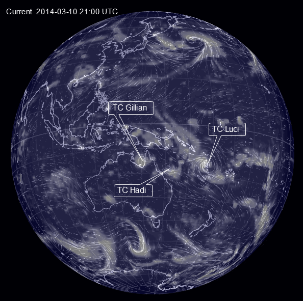
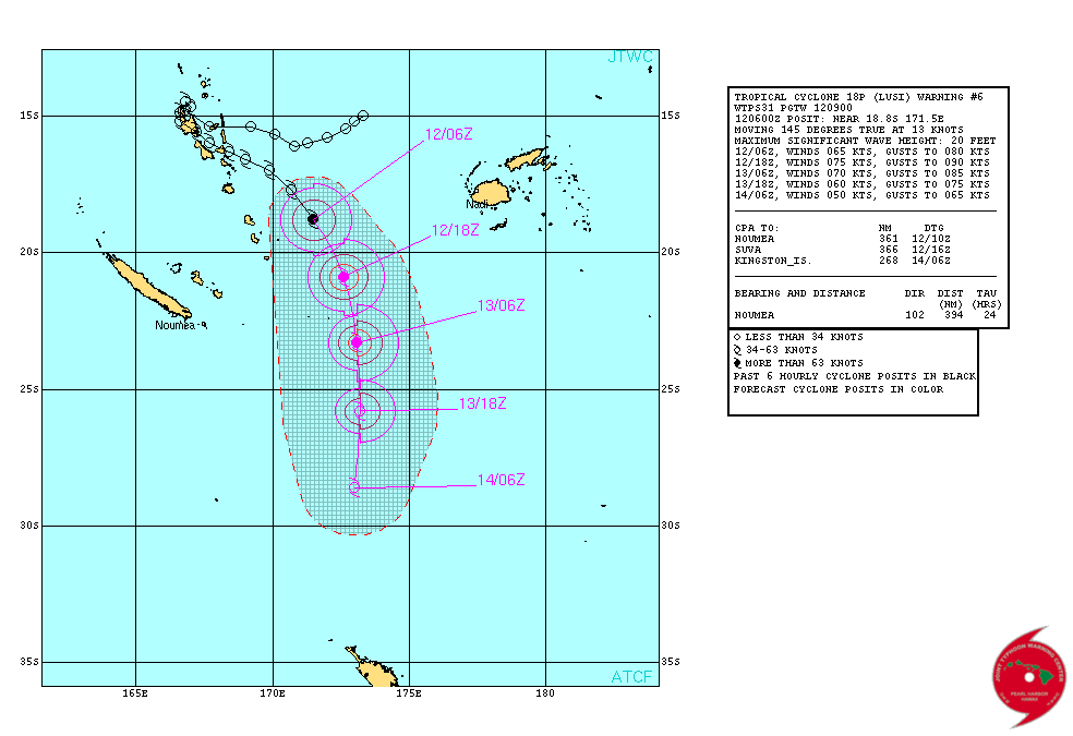
TC LUCI update
remarks:
120900z position near 19.3s 171.8e.
tropical cyclone (TC) 18p (Lusi), located approximately 395 nm west
of Suva, Fiji, has tracked southeastward at 13 knots over the past
six hours. Animated multispectral satellite imagery depicts a
consolidating system with tightly-curved banding wrapping into a
ragged eye. this improved structure is evident in a 120341z trmm
image, therefore, there is high confidence in the current position.
The current intensity is assessed at 65 knots based on a knes dvorak
estimate of 65 knots, and is also supported by the improved
organization of the low-level circulation center. TC 18p is turning
poleward along the western periphery of a north-south oriented
steering ridge and is forecast to continue tracking southward
through the forecast period. dynamic guidance is in tight agreement,
therefore, there is high confidence in the jtwc forecast track. TC
18p is forecast to intensify to a peak intensity of 75 knots by tau
12 but should then weaken as it encounters increasing vertical wind
shear and cooler sst. The system should begin extra-tropical
transition (ett) near tau 24 as it interacts with the baroclinic
zone, and is expected to complete ett by tau 48 as it gains frontal
characteristics and becomes embedded in strong westerly upper-level
flow.
Maximum significant wave height at 120600z is 20 feet. next
warnings at 122100z and 130900z.//
www.usno.navy.mil...
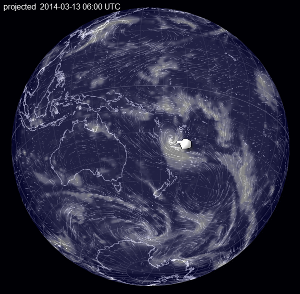
Earth:: projected 0600 13/03/2014UTC
remarks:
120900z position near 19.3s 171.8e.
tropical cyclone (TC) 18p (Lusi), located approximately 395 nm west
of Suva, Fiji, has tracked southeastward at 13 knots over the past
six hours. Animated multispectral satellite imagery depicts a
consolidating system with tightly-curved banding wrapping into a
ragged eye. this improved structure is evident in a 120341z trmm
image, therefore, there is high confidence in the current position.
The current intensity is assessed at 65 knots based on a knes dvorak
estimate of 65 knots, and is also supported by the improved
organization of the low-level circulation center. TC 18p is turning
poleward along the western periphery of a north-south oriented
steering ridge and is forecast to continue tracking southward
through the forecast period. dynamic guidance is in tight agreement,
therefore, there is high confidence in the jtwc forecast track. TC
18p is forecast to intensify to a peak intensity of 75 knots by tau
12 but should then weaken as it encounters increasing vertical wind
shear and cooler sst. The system should begin extra-tropical
transition (ett) near tau 24 as it interacts with the baroclinic
zone, and is expected to complete ett by tau 48 as it gains frontal
characteristics and becomes embedded in strong westerly upper-level
flow.
Maximum significant wave height at 120600z is 20 feet. next
warnings at 122100z and 130900z.//
www.usno.navy.mil...
Earth:: projected 0600 13/03/2014UTC
TC LUCI
JTWC NEXT WARNING AT 122100Z (131100LOCAL)
LATEST POSITION
121800Z (130700LOCAL)--- 20.9S 172.6E
MAX SUSTAINED WINDS - 075 KT, GUSTS 090 KT
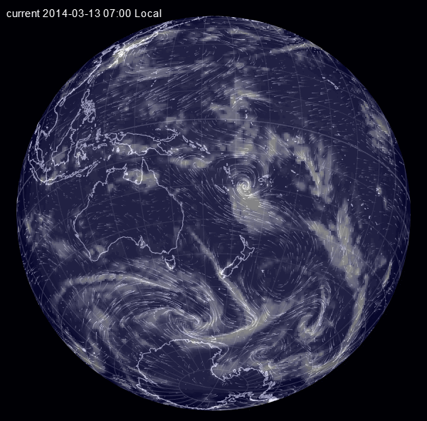
current position on Earth::
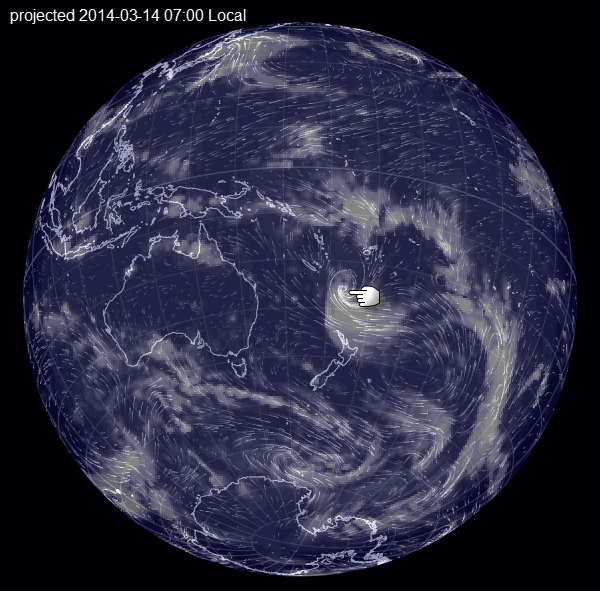
projected 24hrs from now
JTWC NEXT WARNING AT 122100Z (131100LOCAL)
LATEST POSITION
121800Z (130700LOCAL)--- 20.9S 172.6E
MAX SUSTAINED WINDS - 075 KT, GUSTS 090 KT
current position on Earth::
projected 24hrs from now
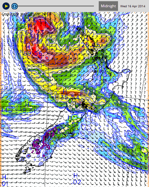
ex TC Luci about to hit NZ
Cyclone Lusi forecast to bring heavy rain and easterly gales to many places.
Cyclone Lusi is expected to move southwards today (Friday), bringing widespread heavy rain and easterly gales to the North Island from tonight (Friday night), and the upper South Island during Saturday. Rain is forecast to become heavy in Northland this evening, and 80-100mm are likely to have accumulated there by Saturday afternoon. The rain should spread quickly southwards, totalling more than 100mm in Coromandel, Bay of Plenty and Gisborne by Sunday morning.
In the upper South Island, Marlborough and Nelson look set to receive the most intense rainfall, with up to 170mm accumulating in the Nelson ranges from Saturday afternoon till noon Sunday.
Easterly gales will accompany the heavy rain, with severe gusts of 120km/h in Northland, Auckland and Coromandel Peninsula, and 130km/h west of the Kaimai Range.
www.metservice.com...
edit on 03000000727214 by muzzy because: opps wrong map
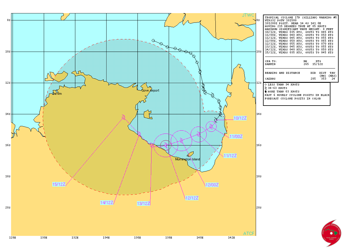
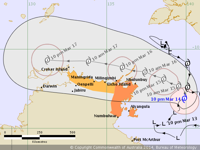
TC GILLIAN went back on itself in the Gulf and rebooted ......... headed for Darwin
Australian Government Bureau of Meteorology
Northern Territory
Tropical Cyclone Warning Centre
Media: The Standard Emergency Warning Signal should NOT be used with this
warning.
TOP PRIORITY FOR IMMEDIATE BROADCAST
TROPICAL CYCLONE WARNING
TROPICAL CYCLONE ADVICE NUMBER 43
Issued at 10:49 pm CST on Friday 14 March 2014
A Cyclone WARNING continues for coastal and island communities from Elcho
Island to Numbulwar, including Alyangula and Nhulunbuy
A Cyclone WATCH continues for coastal areas from Croker Island to Elcho Island
At 9:30 pm CST Tropical Cyclone Gillian was estimated to be
350 kilometres east southeast of Nhulunbuy and
380 kilometres east northeast of Groote Eylandt
moving northeast at 10 kilometres per hour.
TROPICAL CYCLONE GILLIAN is moving slowly northeast over the Gulf of
Carpentaria. Tropical Cyclone Gillian is expected to turn northwest tonight and
move towards the northeast Arnhem district. It is expected to reach the coast
near Nhulunbuy early Sunday morning. It is then expected to continue moving
west near the north coast of the Top End.
GALES with gusts to 110 kilometres per hour are expected to develop between
Numbulwar and Nhulunbuy, including Alyangula, during Saturday, extending to
Elcho Island on Sunday.
GALES may extend further west to Maningrida on Sunday, then Croker Island on
Sunday night.
Tides will be HIGHER THAN NORMAL between Numbulwar and Nhulunbuy. Large waves
may produce MINOR FLOODING of low-lying coastal areas.
HEAVY RAIN may lead to flash flooding in coastal areas of northeast Arnhem Land
on Saturday night, extending west across the north coast on Sunday and Monday.
The Territory Controller advises residents from Elcho Island to Numbulwar that
now is the time to make final preparations to your home shelter.
www.bom.gov.au...
edit on 03u727214 by muzzy because: add link
TC Twenty Three (or TC Ita as the Aussies have called it)
This is the one that developed over Solomon Islands and caused all the flooding in Honiara that is in the News
BUREAU OF METEOROLOGY TRACK MAP
JTWC Warning too
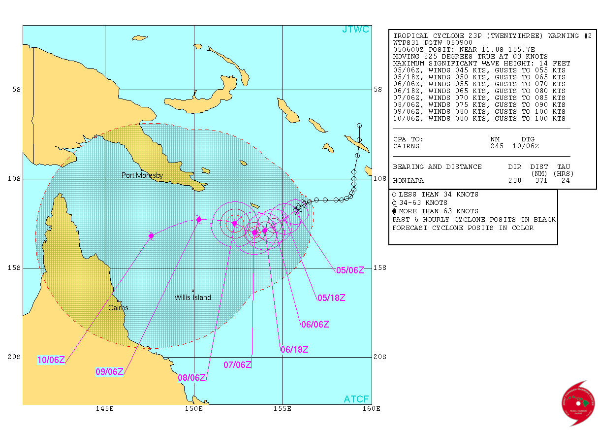
This is the one that developed over Solomon Islands and caused all the flooding in Honiara that is in the News
HIGH SEAS WEATHER WARNING FOR METAREA 10 ISSUED BY THE
AUSTRALIAN BUREAU OF METEOROLOGY TROPICAL CYCLONE WARNING CENTRE BRISBANE
AT 1247UTC 5 APRIL 2014
STORM FORCE WIND WARNING FOR NORTH EASTERN AREA
SITUATION
At 1200 UTC Tropical Cyclone Ita was centred within 50 nautical miles of
latitude twelve decimal zero south (12.0S)
longitude one hundred and fifty five decimal eight east (155.8E)
Recent movement : west southwest at 3 knots
Maximum winds : 35 knots
Central pressure: 997 hPa
AREA AFFECTED
Within 90 nautical miles in NE quadrant
and within 120 nautical miles in SE quadrant
and within 120 nautical miles in SW quadrant
and within 70 nautical miles in NW quadrant.
FORECAST
Maximum winds to 35 knots near the centre increasing to 60 knots by 1200 UTC 06
April.
At 0000 UTC 06 April: Within 85 nautical miles of 12.3 south 154.9 east
Central pressure 982 hPa.
Winds to 60 knots near centre.
At 1200 UTC 06 April: Within 110 nautical miles of 12.6 south 154.4 east
Central pressure 980 hPa.
Winds to 60 knots near centre.
REMARKS
All ships in the area please send weather reports every three hours. Regular
weather observing ships use normal channels. Other ships please use either
email to [email protected] or fax to +61732200221 or satellite using SAC1241
through Land Earth Station Burum 312 [or 212 as appropriate] via Perth.
Next warning will be issued by 1900 UTC 05 April 2014.
WEATHER BRISBANE
www.bom.gov.au...
BUREAU OF METEOROLOGY TRACK MAP
JTWC Warning too
edit on 04u949414 by muzzy because: (no reason given)
edit on 04u949414 by muzzy because: (no reason
given)
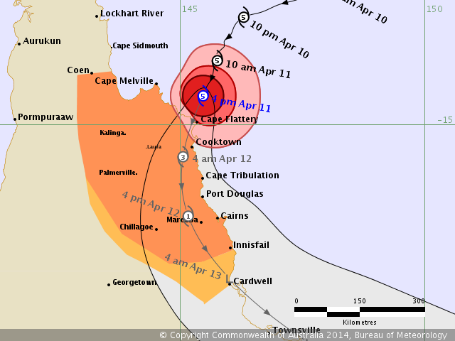
Category 5 about to hit the N Queensland Coast
www.bom.gov.au...
JTWC Warning
PAN PAN Severe Tropical Cyclone Ita
HIGH SEAS WEATHER WARNING FOR METAREA 10 ISSUED BY THE
AUSTRALIAN BUREAU OF METEOROLOGY TROPICAL CYCLONE WARNING CENTRE BRISBANE
AT 0106UTC 11 APRIL 2014
HURRICANE FORCE WIND WARNING FOR NORTH EASTERN AREA
SITUATION
At 0100 UTC Severe Tropical Cyclone Ita was centred within 10 nautical miles of
latitude thirteen decimal eight south (13.8S)
longitude one hundred and forty five decimal seven east (145.7E)
Recent movement : south southwest at 4 knots
Maximum winds : 115 knots
Central pressure: 931 hPa
AREA AFFECTED
Within 90 nautical miles in NW quadrant extending to 100 nautical miles in
remaining quadrants
FORECAST
Maximum winds to 115 knots near the centre.
Winds above 64 knots within 25 nautical miles of centre with very high to
phenomenal seas.
Winds above 48 knots within 45 nautical miles of centre with high seas and
moderate swell.
Winds above 34 knots Within 90 nautical miles in NW quadrant extending to 100
nautical miles in remaining quadrants with very rough seas and moderate swell.
Forecast positions
At 1300 UTC 11 April: Within 35 nautical miles of 14.9 south 145.2 east
Central pressure 930 hPa.
Winds to 115 knots near centre.
At 0100 UTC 12 April: Within 65 nautical miles of 16.1 south 145.0 east over
land
Central pressure 991 hPa.
Winds to 50 knots near centre.
www.bom.gov.au...
edit on 0400000010010014 by muzzy because: (no reason given)
JTWC Warning
edit on 0400000010010014 by muzzy because: (no
reason given)
edit on 04u10010014 by muzzy because: In case you are wondering, PAN PAN stands for Pay Attention Now. It is used on
various maritime and aeronautical radio communications.
Ex TC Ita now sideswiping New Zealand,
www.metservice.com...
been raining quite heavy here Cook Strait area for about 6 hours, been wet all day though.
www.metservice.com...
been raining quite heavy here Cook Strait area for about 6 hours, been wet all day though.
edit on 04u10510514 by muzzy because: (no reason given)
new topics
-
Israel attacking Iran again.
Middle East Issues: 31 minutes ago -
Michigan school district cancels lesson on gender identity and pronouns after backlash
Education and Media: 35 minutes ago -
When an Angel gets his or her wings
Religion, Faith, And Theology: 1 hours ago -
Comparing the theology of Paul and Hebrews
Religion, Faith, And Theology: 2 hours ago -
Pentagon acknowledges secret UFO project, the Kona Blue program | Vargas Reports
Aliens and UFOs: 3 hours ago -
Boston Dynamics say Farewell to Atlas
Science & Technology: 3 hours ago -
I hate dreaming
Rant: 4 hours ago -
Man sets himself on fire outside Donald Trump trial
Mainstream News: 5 hours ago -
Biden says little kids flip him the bird all the time.
Politicians & People: 6 hours ago -
The Democrats Take Control the House - Look what happened while you were sleeping
US Political Madness: 6 hours ago
top topics
-
The Democrats Take Control the House - Look what happened while you were sleeping
US Political Madness: 6 hours ago, 17 flags -
In an Historic First, In N Out Burger Permanently Closes a Location
Mainstream News: 8 hours ago, 14 flags -
Biden says little kids flip him the bird all the time.
Politicians & People: 6 hours ago, 8 flags -
A man of the people
Medical Issues & Conspiracies: 14 hours ago, 8 flags -
Man sets himself on fire outside Donald Trump trial
Mainstream News: 5 hours ago, 7 flags -
Pentagon acknowledges secret UFO project, the Kona Blue program | Vargas Reports
Aliens and UFOs: 3 hours ago, 5 flags -
4 plans of US elites to defeat Russia
New World Order: 15 hours ago, 4 flags -
Sheetz facing racial discrimination lawsuit for considering criminal history in hiring
Social Issues and Civil Unrest: 6 hours ago, 3 flags -
Boston Dynamics say Farewell to Atlas
Science & Technology: 3 hours ago, 3 flags -
Are you ready for the return of Jesus Christ? Have you been cleansed by His blood?
Religion, Faith, And Theology: 11 hours ago, 3 flags
active topics
-
Candidate TRUMP Now Has Crazy Judge JUAN MERCHAN After Him - The Stormy Daniels Hush-Money Case.
Political Conspiracies • 403 • : Threadbarer -
Israel attacking Iran again.
Middle East Issues • 11 • : theatreboy -
Cat Movies
Movies • 19 • : 5thHead -
Man sets himself on fire outside Donald Trump trial
Mainstream News • 33 • : ByeByeAmericanPie -
Pentagon acknowledges secret UFO project, the Kona Blue program | Vargas Reports
Aliens and UFOs • 6 • : Ophiuchus1 -
Israeli Missile Strikes in Iran, Explosions in Syria + Iraq
World War Three • 104 • : CCoburn -
The Acronym Game .. Pt.3
General Chit Chat • 7732 • : RAY1990 -
Michigan school district cancels lesson on gender identity and pronouns after backlash
Education and Media • 3 • : Consvoli -
Are you ready for the return of Jesus Christ? Have you been cleansed by His blood?
Religion, Faith, And Theology • 20 • : RAY1990 -
The Democrats Take Control the House - Look what happened while you were sleeping
US Political Madness • 63 • : NoCorruptionAllowed