It looks like you're using an Ad Blocker.
Please white-list or disable AboveTopSecret.com in your ad-blocking tool.
Thank you.
Some features of ATS will be disabled while you continue to use an ad-blocker.

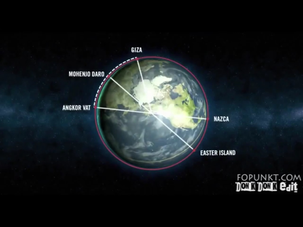
Ancient Sites & Monuments Aligned To "Ancient Equator"
page: 5share:
Well supposing this theory is true, isn't it possible to confirm the theory by predicting the location of a sunken city? Following the same
"equator" as those in this pic but somewhere out in the ocean presumably with a correct mathematical equivalent to those depicted here:
If a site was accurately "predicted" wouldn't that validate this theory once and for all? Anyone gotta a submarine?
If a site was accurately "predicted" wouldn't that validate this theory once and for all? Anyone gotta a submarine?
jeep3r
The moai were built between 1250 ad and 1500 ad, the giza pyramids around 2500 bce, unless you want explain how that is magically possible or deny that human dating methods based on physics is wrong, go for either because what you came up with is impossible.
This is highly debatable ... do we really have conclusive proof for the construction dates of the monuments you mentioned above? I don't think so, and especially the Moai on Easter Island and some of the structures on Giza Plateau (or Sacsayhuaman) can certainly not be traced back to their very origins using the dating methods we currently have.edit on 20-1-2014 by jeep3r because: text
I see.
So, dates associated with each of the cultures you claim your line comes "near" have been mislocated in the timeline of history by the ignorance of science?
And the evidence for this is the line you drew, eh?
Sorry, seems a little unconvincing.
Harte
Harte
So, dates associated with each of the cultures you claim your line comes "near" have been mislocated in the timeline of history by the ignorance of science?
And the evidence for this is the line you drew, eh?
Sorry, seems a little unconvincing.
Hello, Harte ... I was already waiting for your response to that comment of mine!
With respect to your profession and the work of other archeologists, I'm not saying that science isn't getting it right ... the cultures were there and what you dig up and associate with artifacts from the vicinity proves that such & such peoples were living in that area.
On the other hand: The dating of some structures can't be determined for sure. And again (no tyranny of possibilities here): with regard to certain megalithic sites & construction methods we still have a lot of open questions to answer and IMO we shouldn't make all that fit into some paradaigm just to have it out of our way.
jeep3r
Harte
So, dates associated with each of the cultures you claim your line comes "near" have been mislocated in the timeline of history by the ignorance of science?
And the evidence for this is the line you drew, eh?
Sorry, seems a little unconvincing.
Hello, Harte ... I was already waiting for your response to that comment of mine!
With respect to your profession and the work of other archeologists, I'm not saying that science isn't getting it right ... the cultures were there and what you dig up and associate with artifacts from the vicinity proves that such & such peoples were living in that area.
On the other hand: The dating of some structures can't be determined for sure. And again (no tyranny of possibilities here): with regard to certain megalithic sites & construction methods we still have a lot of open questions to answer and IMO we shouldn't make all that fit into some paradaigm just to have it out of our way.
I'm not an archaeologist.
I teach Geometry and Physics.
However, I'd be interested to see why you believe that the various methods used to date the sites in question are not able to determine dates for sure.
That is, there are certainly ranges given with each dating method. But in the cases of most of the sites around this spurious "equator," even taking into account these ranges will not cause the cultures to overlap.
Now, there are many sites that can't be positively dated, if that's what you mean. But how many of them are near the line this post concerns?
As far as I know, some sites on Malta - no certain date range because of the absence of artifacts and organics - are the nearest. But they're not really near, not as near as the specification from the OP.
There's no question at all concerning Easter Island. Nor is there any question concerning Giza.
Can you elucidate?
Harte
Harte
So, how many ancient sites are left out to make this "equator?"
What about Stonehenge?
My thought as well. I definitely wasn't seeing Teotihuacan on that list. I guess they don't count.
I also wonder exactly where in these various sites is the exact point of crossing. Like the Nazca plains, for instance. Where exactly in that fairly large group of geoglyphs does this supposed equator cross? Right through the middle? Across a particular symbol?
Because even poor slobs like ourselves with our primitive tools can pretty much build a structure to within an inch of where we want it. How much credit for accuracy are we willing to give these ancient geniuses? If you're drawing on a globe lines that are many miles wide, how close is "close enough?"
I tend to think that people built large monuments and cities in the places they lived. Near good fresh water sources and farmland.
Harte
However, I'd be interested to see why you believe that the various methods used to date the sites in question are not able to determine dates for sure.
Rocks and stones in general are difficult to date. Radiocarbon dating is debatable and only works for organics up to about 60.000 years before present. Unearthed artifacts and writings of those cultures probably are a good foundation to say who was around in that area at a specific time.
But that's perhaps just 'part' of the story. So what about cultures that don't even claim having built their most impressive megalithic accomplishments themselves, yet archaeology officially associates these structures with that particular culture? I think these are also open issues that make conclusive statements about construction dates & methods impossible at this point in time ...
That is, there are certainly ranges given with each dating method. But in the cases of most of the sites around this spurious "equator," even taking into account these ranges will not cause the cultures to overlap.
What we think we know about the history of certain cultures that lived in those areas doesn't overlap, true ... but as mentioned above, when considering the variety of different construction methods on one site (eg. megalithic vs. non-megalithic etc.), not all of it should be attributed to that one culture for which we have the most evidence, IMO that would be too much of a generalization and should be left open until conclusive proof can be delivered.
Blue Shift
I also wonder exactly where in these various sites is the exact point of crossing. Like the Nazca plains, for instance. Where exactly in that fairly large group of geoglyphs does this supposed equator cross? Right through the middle? Across a particular symbol?
The bottom-most part of the Nazca Lines is located about 5 km to the north of that line. When considering the vast distance of 20.000km between the first site and the last, that's a rather 'unusual accomplishment' IMO!
edit on 20-1-2014 by jeep3r because: text
I find this subject fascinating and have read a lot about ancient civilisations. I wonder, has anyone compared this alignment with Bruce Cathie's
energy grid? His work into earth harmonics in the 60's led him to believe there used to be/still is, a worldwide energy grid. There used to be
software that he had designed that could map this out and major monuments all related to main grid lines, including recent buildings like Parliament,
DC, Washington monument etc...
I wonder if this ancient 'equatorial' alignment is actually the central point, or equator, of the worldwide energy grid that Bruce Cathie discovered. If anyone has looked into this, or has the software, I'd love to know.
Also, has anyone looked at how these monuments would align if the expanding earth theory were true? (it would certainly be interesting).
Ancient writing and glyphs are common in far flung places, as are building materials and techniques, there's also the legend (it's even in the bible somewhere) of a former, lost, universal language. I realise it's a stretch if we go by accepted timelines, but it would certainly make sense for all these practices to be common and shared, if a once lost ancient people all lived on one unbroken piece of land i.e, before expansion or drift.
It may be worth suspending disbelief and seeing how the alignments fit to an ancient state of earth.
reply to post by cobainpain
The Bible story/history of the tower of Babel, seems to point to the fact that there was a Universal language at some time. If this is a fact then there must have been contact of some sort to keep the language from disintegrating into dialects. Cocaine and Nicotine have been found in mummies, the only real history of Egypt is from the New kingdom. All else is conjecture .The line in question could be the area of ice free land before the big melt/flood. This would tend to force human populations into land that was productive. then after the chaos of the flooding/climate change, language could very well have become localised into dialects. The Jewish interpretation was that God got angry at mankind building a tower to heaven. Could the GP. have been this tower. Its got far to many mathematical coincidences, for it to be just happenstance. As far as it being a tomb then where's the body?
The Bible story/history of the tower of Babel, seems to point to the fact that there was a Universal language at some time. If this is a fact then there must have been contact of some sort to keep the language from disintegrating into dialects. Cocaine and Nicotine have been found in mummies, the only real history of Egypt is from the New kingdom. All else is conjecture .The line in question could be the area of ice free land before the big melt/flood. This would tend to force human populations into land that was productive. then after the chaos of the flooding/climate change, language could very well have become localised into dialects. The Jewish interpretation was that God got angry at mankind building a tower to heaven. Could the GP. have been this tower. Its got far to many mathematical coincidences, for it to be just happenstance. As far as it being a tomb then where's the body?
reply to post by jeep3r
jesus you werent #ing with me. i drew that stuff on a map. they do make a line going diagonal through SA and africa with a suprrisingly accurate correlation
jesus you werent #ing with me. i drew that stuff on a map. they do make a line going diagonal through SA and africa with a suprrisingly accurate correlation
You may want to check out the following site: www.geekglyph.com. This group has done some very interesting work with the Nazca-Palpa lines and
figures, using Google Earth. Seems the complex may be a global map or template. The great circle we're discussing here may be the former equator, OR,
a future one !! Check it out.....
jeep3r
Harte
However, I'd be interested to see why you believe that the various methods used to date the sites in question are not able to determine dates for sure.
Rocks and stones in general are difficult to date. Radiocarbon dating is debatable and only works for organics up to about 60.000 years before present. Unearthed artifacts and writings of those cultures probably are a good foundation to say who was around in that area at a specific time.
Writing only goes back around 5500 years. I was under the impression that the thread was about this ancient equator from far before that.
That is, if not, don't you think someone would have noticed the Earth tilting over and maybe written something about that?
Regarding C14, yes it "only" goes back 60,000 years. But that's plenty far for every megalithic (at least) site they've used it on. And while C14 doesn't date rock, as you point out, it does date any organics found under a rock.
These sorts of organic materials (and, of course, others) have been dated at Pumapuku and throughout the Tiahuanaco site proper, as well as all around the surrounding countryside.
jeep3rBut that's perhaps just 'part' of the story. So what about cultures that don't even claim having built their most impressive megalithic accomplishments themselves, yet archaeology officially associates these structures with that particular culture? I think these are also open issues that make conclusive statements about construction dates & methods impossible at this point in time ...
I assume you mean the Inca here.
It's true that some so-called Inca sites might have been erected by an earlier culture. But the cultures in Peru are all directly related over time. Mostly, sites are called "Incan" in the press when they aren't because nobody has heard of the Wari, etc.
Note the chart on page 10 of this PDF.
You can see that, while you often note people calling Tiahuanaco an "Incan" site, it is actually not regarded as such.
Other sites dwelt on by fringe believers certainly are Incan. For example, there's little to no doubt at all this is true of Ollantaytambo
jeep3r
That is, there are certainly ranges given with each dating method. But in the cases of most of the sites around this spurious "equator," even taking into account these ranges will not cause the cultures to overlap.
What we think we know about the history of certain cultures that lived in those areas doesn't overlap, true ... but as mentioned above, when considering the variety of different construction methods on one site (eg. megalithic vs. non-megalithic etc.), not all of it should be attributed to that one culture for which we have the most evidence, IMO that would be too much of a generalization and should be left open until conclusive proof can be delivered.
I don't believe that this is the case, though admittedly you can, as I said, see it happen on websites and newspapers, etc.
Harte
Varhaard
...Not to mention that there would be evidence of magnetic pole movements/reversals in ancient lavas, and ice core data would definitely record such an event if it happened in the last 450,000 years...
This gave me the idea - what if the poles didn't move, but rather the mantle over the liquid core?
If the mantle rotated over the liquid (moving the crust with it), the landmass/ocean layout wouldn't change.

The inner core producing the poles may only be capable of "drifting" (being surrounded by liquid), so the pole orientation stays relatively the same over time, explaining the lack evidence for a great pole shift.

Continental drift, axis wobble, pole shift/drift may not of been necessary to produce what the OP is questioning...
What's under the equator could of moved as a whole.
It could of been caused by an impact whose trajectory had a skimming effect on the surface, or some as of yet unknown natural occurrence.
I'm not saying I believe that's what happened, but what I came up with to explain the OP's out of place equator.
I was going to make an animated gif showing the mantle/crust rotating as one piece over the liquid, while the inner core stayed still, but I typed this instead.
First time post & have always enjoyed great threads from here for years. I felt compelled to create an account to post this documentary I just saw.
It's the best I've seen in regards to the builders of these megalith structures over the world; particularly the Great Pyramid. If it's been posted
before I apologize in advance. It's a bit long but well worth it & very informative:
www.disclose.tv...
reply to post by cobainpain
Thank you for pointing out fitting a much older cultures ideas/structures into the present day may be causing us to misinterpret things.
The thought that the equator was different than it is currently is an intriguing one. If you look at structural discoveries one can't help but observe the inevitable catchment phrases include " it was an astronomical site" or a "sacred religious site". Personally I'm tired of the very lazy thinking this demonstrates.
Hopefully in the distant future some schmuck will pronounce the Cheyenne Mt. Military base the epicenter of a underworld ceremonial site, so this folly will have gone full bore multi-millenial facepalm. Better yet the seed bank on Svalsbard will be pronounced a great granary, thus causing future archeologists to dig all over the arctic looking for the obviously lost cities it "supported".
Starting with a new theoretical equatorial line instead of throwing every thing at it and seeing what sticks, maybe matching up the monolithic building styles and moving out from there would be of benefit? The notion of orbital markers or that humanity has risen and fallen multiple times can be added as observational evidence is built upon?
Science to date has been pretty arrogant in that discoveries are fiercely defended since careers are built on what has been found "to date" and there is a very biased motive in keeping what we think of as "true" from being tossed out. Ooparts continually are brushed under the rug instead of factored in, oral histories are marginalized, our dating systems are still in their infancy.
OP it might have been better if you started this thread in Skunkworks to better facilitate a flow of new ideas. JMO
RedmoonMWC
reply to post by jeep3r
I have seen this presented in a utube vid, I'll see if I can find it again.
FYI moving the equator to this new (old) position puts the North Pole in the approximate area of Prince William Sound in Alaska, USA and moves the south pole approx. 30 degrees north almost completely out of the Antarctic circle.
I find it very interesting that you pinpoint "the old North Pole" in the area of Prince William Sound in Alaska.
A while back I heard Linda Moulton Howem, from Earthfiles.com, investigating a possible Black Underground Pyramid in Alaska. There were never any evidence found of this pyramid, only a few witnesses that said to have been there or heard about it. The investigation led to these coordinates: 63°17'51.40"N 152°31'24.49"W
That place is just 400km away from Prince William Sound. All of a sudden Lindas investigation got allot more interesting. I cant get the report from Earthfiles.com because a subscription is needed, but there is allot of info to be found with just a simple google search.
Great thread op .
Didn't these lines used to be called ley lines?
Didn't these lines used to be called ley lines?
I
a reply to: SLAYER69
I am enjoying that others have noticed the alignments of some of the worlds oldest ad most important
buildings/ pyramids and that the line circumnavigates around the globe along this former 'equator' line, and is only about 1 meter wide. That is rather bizarre considering these pyramids 'sprung up' about 3-9 thousand years ago.
Who orchestrated the alignment. Besides the amazing construction.. Especially Giza. That suddenly all the ancient tribes suddenly knew how to create interlocked blocks and precise measurements.
It seems to me that these may actually cause a weight/magnetic shift which acts something like the lead weights tire installations need to remove 'wobble' as the tire spins..
Additionally it seems like the 'time' to move the equatorial alignment back and forth is a tool to guide or be able to measure what is coming.
The next big 'wobble' and instead of a flood..it will be the big 'burn'..
Just some thoughts I'm having..anyone think I'm totally crazy?
At any rate I am planning a trip around the globe to measure EMF's, etc. and photograph the locations. I mostly want to 'feel' the sites up close and personal.
Thanks for posting this,
cheers
Lee
new topics
-
In an Historic First, In N Out Burger Permanently Closes a Location
Mainstream News: 48 minutes ago -
MH370 Again....
Disaster Conspiracies: 1 hours ago -
Are you ready for the return of Jesus Christ? Have you been cleansed by His blood?
Religion, Faith, And Theology: 3 hours ago -
Chronological time line of open source information
History: 4 hours ago -
A man of the people
Diseases and Pandemics: 6 hours ago -
Ramblings on DNA, blood, and Spirit.
Philosophy and Metaphysics: 6 hours ago -
4 plans of US elites to defeat Russia
New World Order: 7 hours ago -
Thousands Of Young Ukrainian Men Trying To Flee The Country To Avoid Conscription And The War
Other Current Events: 11 hours ago
top topics
-
Israeli Missile Strikes in Iran, Explosions in Syria + Iraq
World War Three: 14 hours ago, 17 flags -
In an Historic First, In N Out Burger Permanently Closes a Location
Mainstream News: 48 minutes ago, 9 flags -
Thousands Of Young Ukrainian Men Trying To Flee The Country To Avoid Conscription And The War
Other Current Events: 11 hours ago, 7 flags -
Iran launches Retalliation Strike 4.18.24
World War Three: 14 hours ago, 6 flags -
12 jurors selected in Trump criminal trial
US Political Madness: 14 hours ago, 4 flags -
4 plans of US elites to defeat Russia
New World Order: 7 hours ago, 4 flags -
A man of the people
Diseases and Pandemics: 6 hours ago, 3 flags -
Chronological time line of open source information
History: 4 hours ago, 2 flags -
Are you ready for the return of Jesus Christ? Have you been cleansed by His blood?
Religion, Faith, And Theology: 3 hours ago, 1 flags -
MH370 Again....
Disaster Conspiracies: 1 hours ago, 1 flags
active topics
-
4 plans of US elites to defeat Russia
New World Order • 29 • : Oldcarpy2 -
12 jurors selected in Trump criminal trial
US Political Madness • 44 • : iaylyan -
Do we live in a simulation similar to The Matrix 1999?
ATS Skunk Works • 23 • : JoelSnape -
Are you ready for the return of Jesus Christ? Have you been cleansed by His blood?
Religion, Faith, And Theology • 13 • : Cvastar -
In an Historic First, In N Out Burger Permanently Closes a Location
Mainstream News • 2 • : Irishhaf -
MH370 Again....
Disaster Conspiracies • 4 • : Vermilion -
George Knapp AMA on DI
Area 51 and other Facilities • 23 • : Raptured -
President BIDEN Warned IRAN Not to Attack ISRAEL - Iran Responded with a Military Attack on Israel.
World War Three • 44 • : WeMustCare -
AARO/Dr Kirkpatrick-Caught Lying in UAP report.
Aliens and UFOs • 27 • : Cvastar -
The Acronym Game .. Pt.3
General Chit Chat • 7731 • : CCoburn