It looks like you're using an Ad Blocker.
Please white-list or disable AboveTopSecret.com in your ad-blocking tool.
Thank you.
Some features of ATS will be disabled while you continue to use an ad-blocker.

The Ongoing Long Valley Supervolcano Threat- and What Happened There in the 1980's-90's
page: 1share:
So imagine you have your own piece of sweet reality in eastern California. You're a business owner in the resort town of Mammoth Lakes, when over the
course of several years, massive earthquakes start happening, along with intense earthquake swarms, gas emissions and ground inflation- all around and
in the caldera. And there is talk of a massive volcanic hazard right in your own back yard coming from the scientific community.
How would you react?
Well in order to get a further understanding of the grave events that occurred there and which caused considerable anguish to the many communities in and around Long Valley, I emailed one of my many scientific sources about this. I was sent an interesting document, which goes into considerable detail about this very subject, and the tense atmosphere of those trying times. Public reactions to the intense volcanic unrest varied widely. Many scientists were shunned, and some business owners even put up "Geologists Not Welcome" signs on their storefronts.
As scientists wrestled with the ongoing unrest, a series of Long Period volcanic events began under Mammoth Mountain, prompting further alarm bells. It really was "downright scary," as one of my other sources has recounted to me in emails over the years.
Here they had a supervolcano, with potential to bring some serious devastation to the entire western seaboard of the US, exhibiting just about ALL of the signs of a potential eruption looming: Big quakes M>6, ground deformation with the resurgent dome rising at an increasing rate, increased magmatic CO2 emissions saturating the ground, intense earthquake swarms, and long period events detected so close together it bordered on being volcanic tremor.
And as it turns out, the current volcanic alert system was actually developed from the events that occurred there, as scientists struggled with disseminating emerging information to an extremely skeptical and even vindictive, public.
So in order for you to understand the setting for this, and just how bad this got, have a look at this, from the document I was sent (sorry, you guys just gonna have to trust me on this one, as I cannot provide a source link- but suffice it to say this came from a well respected scientist, written in 1998):
(Continued next post)
How would you react?
Well in order to get a further understanding of the grave events that occurred there and which caused considerable anguish to the many communities in and around Long Valley, I emailed one of my many scientific sources about this. I was sent an interesting document, which goes into considerable detail about this very subject, and the tense atmosphere of those trying times. Public reactions to the intense volcanic unrest varied widely. Many scientists were shunned, and some business owners even put up "Geologists Not Welcome" signs on their storefronts.
As scientists wrestled with the ongoing unrest, a series of Long Period volcanic events began under Mammoth Mountain, prompting further alarm bells. It really was "downright scary," as one of my other sources has recounted to me in emails over the years.
Here they had a supervolcano, with potential to bring some serious devastation to the entire western seaboard of the US, exhibiting just about ALL of the signs of a potential eruption looming: Big quakes M>6, ground deformation with the resurgent dome rising at an increasing rate, increased magmatic CO2 emissions saturating the ground, intense earthquake swarms, and long period events detected so close together it bordered on being volcanic tremor.
And as it turns out, the current volcanic alert system was actually developed from the events that occurred there, as scientists struggled with disseminating emerging information to an extremely skeptical and even vindictive, public.
So in order for you to understand the setting for this, and just how bad this got, have a look at this, from the document I was sent (sorry, you guys just gonna have to trust me on this one, as I cannot provide a source link- but suffice it to say this came from a well respected scientist, written in 1998):
A M~ = 5.8 earthquake on October 4, 1978, located beneath Wheeler Crest 14 km southeast of Long Valley caldera (roughly midway between Bishop and Mammoth Lakes), marked the onset of the extended episode of unrest in the caldera and vicinity that continues today. Over the next year and a half, seismic activity in the form ofM > 3 and occasional M > 4 earthquakes gradually migrated toward the northwest and the southern margin of the caldera.
Then, on May 25, 1980, just seven days after the catastrophic eruption of Mount St. Helens, three M-6 earthquakes shook the southern margin of the caldera, accompanied by a rich aftershock sequence.
By the morning of May 27, the USGS had released a formal "Hazard Watch" noting the possibility of additional M-6 earthquakes in the area. Just hours later, a fourth M-6 earthquake shook the area--a successful "shortterm" forecast!
Jim Savage and Malcolm Clark promptly made arrangements to have a section of Highway 395 through the area releveled to document the coseismic displacement expected from this series of four M-6 earthquakes. What they found instead was a broad, dome-shaped uplift of the caldera floor (the resurgent dome). Monuments near the center of the resurgent dome were 25 cm higher in the summer of 1980 than they had been in 1975. Measurements of a trilateration network spanning the area made in 1979 suggested that most, if not all, of this deformation developed sometime between the summer of 1979 and the summer of 1980. With fresh images of Mount St. Helens in mind, it required no great leap to recognize a volcanic signature in this combination of strong earthquake swarm activity and ground deformation. Still, if the activity had died away as with most aftershock sequences, I suspect our collective attention would have soon focused elsewhere.
Earthquake activity continued, however, with frequent swarms that included locally felt earthquakes (M-3--4 events), rapid-fire bursts of small earthquakes reminiscent of "spasmodic tremor" seen at some volcanoes, and evidence that focal depths were getting shallower with time. In discussions including a number of us in the USGS, the California Division of Mines and Geology (CDMG), and Alan Ryall at
the University of Nevada, Reno over the winter of 1981-82, a consensus developed that we had an obligation to inform local civil authorities of our concerns about the volcanic nature of this activity. A formal draft of such a statement went to the USGS Director's office, followed by an extended
dialogue between the Director's office and the Governor's office in Sacramento over the precise wording of this announcement and how and when it should be released. Officials for Mono and Inyo Counties remained in the dark.
Meanwhile, George Alexander, then a science writer for the Los Angeles Times, got wind that something was up. His article announcing that the USGS was about to release a "Notice of Potential Volcanic Hazards" for the area appeared in the Los Angeles Times on the morning of May 24, 1982 (the Monday before Memorial Day weekend and just one day before the second anniversary of the May 1980 M -6
earthquakes). This, of course, caught both local civil authorities and the citizens of Mono County completely by surprise and short-circuited the official "Notice of Potential Volcanic Hazards" (the lowest level in the Notice/Watch/Warning hazard terminology in use by the USGS at the time), which
was released the next day. The local response was one of outrage, anger, and disbelief ("What volcano?!"), exacerbated by inflammatory headlines and news stories about "brewing lava eruptions" and a town in denial (the Jaws syndrome).
Geologists, and USGS geologists in particular, immediately became personae non gratae in Mammoth Lakes and Mono County, an attitude that only gradually mellowed over the years. Under the best of circumstances, communicating information on a newly recognized hazard is tricky business; this stands as an outstanding example of how to start out on the wrong foot.
(Continued next post)
(Continued from OP)
These are just some excerpts from the document, but- whoa- a supervolcano meeting criteria for Yellow Alert?
I was also sent a link to another more technical document about this unrest, which I can share:
LVC Unrest
I can only wonder what kind of mayhem would occur if a similar situation happened at Yellowstone, and the quakes, deformation, gas emissions and LP events reached those levels. Jesus.
As low-level earthquake swarm activity continued through the summer and fall of 1982, a series of public meetings did little to mitigate the simmering anger. Then, on the afternoon of January 7, 1983, activity abruptly resumed with an intense earthquake swarm in the south moat of the caldera that included two M = 5.3 earthquakes accompanied by nearly constant felt shaking from frequent
M-3-4 earthquakes over the next several weeks. This was an El Nino winter, and the snow was piled high along the roads within Mammoth Lakes and along the only paved road connecting the town to Highway 395. At his own initiative, Mike Jenks, then Chairman of the Mono County Board of Supervisors, ordered a second (dirt) road plowed. He also initiated steps to have this road widened and paved to provide
an alternate way out of town. This was not a popular decision, in part because it carried an implicit acknowledgment that there might actually be a volcanic hazard. Setting some sort of record from inception to completion, the newly paved "escape route" was formally dedicated in October of
1993 as the "Mammoth Scenic Loop."
Meanwhile the Chairman of the Board of Supervisors and a second member of the board who had been proactive in support of the new road and other mitigation issues (including monthly public updates by the USGS on the evolving caldera unrest) were recalled in a special election over the summer.
Releveling of Highway 395 during the summer of 1983 showed that the resurgent dome had been uplifted by an additional 7 cm over the winter. Following the intense January 1983 swarm, however, both the earthquake activity and deformation rates within the caldera activity began a gradual
decline that persisted through the remainder of the 1980s.
... While activity remained low within the caldera following the January 1983 swarm, this was not the case for seismic activity outside the caldera. On November 23, 1984, the M L 6.1 Round Valley earthquake and its many aftershocks (located midway between the southeastern caldera boundary
and Bishop) shook the region. The area again was repeatedly shaken from late July through mid-August 1986 by the rich foreshock and aftershock sequence associated with the M w 6.4 Chalfant Valley mainshock of July 21, 1986, located 20 km southeast of the caldera. Of course, each of these earthquake
sequences generated a flurry of news stories on seismic activity and volcanic unrest in the Mammoth Lakes area, further aggravating the local business leaders over negative publicity.
Activity returned to the vicinity of the caldera with the onset of a persistent earthquake swarm beneath Mammoth Mountain that began in late April 1989 and continued through the end of the year. Although only a handful of earthquakes in this swarm had magnitudes as large as M = 3, the swarm had a "juicy" character with considerable evidence suggesting that it was associated with an intrusion of magma
into the shallow crust beneath Mammoth Mountain. In an effort to keep local civil authorities apprised of the situation, I called the City Manager for Mammoth Lakes several times a week with updates on evolving activity. At one point in a conversation with Steve McNutt (then my counterpart at
CDMG on the Long Valley beat), he asked in apparent exasperation if we couldn't provide him with some sort of written criteria for how seriously he should regard the varying levels of activity. His request led to our developing the "Response Plan for Volcanic Hazards in Long Valley Caldera and the
Mono Craters Area, California" (USGS Open File Report 91-270) that included an alphabetic scheme of five "alert levels" (E through A in ascending order of concern) modeled after that used for the Parkfield earthquake prediction experiment. This response plan was published in June 1991.
In an effort to help local civil authorities better appreciate the issues involved with volcanic hazards, we invited Martin Strelnick (Mono County Sheriff), Boe Turner (Mono County Emergency Services Coordinator), Andrea Mead Lawerence (still a member of the Mono County Board of Supervisors), and Paul Marangella (Mammoth Lakes Town Manager) to attend a conference commemorating the
tenth anniversary of the May 1980 Mount St. Helens eruption. This conference, which was held adjacent to Mount St. Helens in Kelso, Washington, on May 17-19, 1990, included presentations by civil authorities as well as scientists who were directly involved in responding to this catastrophic
eruption. The occasion turned out to be enormously productive for all concerned.
Meanwhile, John Langbein's frequent trilateration measurements with the two-color geodimeter showed that the deformation rate across the resurgent dome began to increase substantially in October of 1989. Three months later, earthquake swarm activity resumed in the south moat of the caldera and has continued to wax and wane to the present, accompanied by relatively steady uplift of the resurgent
dome at a rate of 2-3 cm/year. Other developments that have persisted through the 1990s involve high concentrations ofmagmatic CO 2 in the soil around Mammoth Mountain and a growing number of long-period (LP) volcanic earthquakes occurring at depths of 10-20 km beneath the
southwest flank of Mammoth Mountain. Both of these phenomena began at the time of the 1989 Mammoth Mountain swarm. They serve as a reminder that this 11,000-foot-high volcano, which last erupted 50,000 years ago, is not extinct.
...In April-May of 1997, John Langbein's two-color geodimeter data again showed hints of an increasing deformation rate across the resurgent dome. By early July, earthquake swarm activity in the caldera picked up with an increasing frequency and intensity that persisted through the remainder of the year and into January 1998. The peak in this activity from mid-November through early January 1998 included
nine earthquakes with magnitudes of _M r = 4.0 or greater accompanied by thousands of smaller events. The three largest earthquakes had magnitudes of A//= 4.8-4.9. Resurgent dome deformation escalated through the second half of 1997, reaching a peak rate of over 20 cm/year in mid-November. By the end of the year, the center of the resurgent dome was approximately 7 cm higher than in early May.
...During particularly strong swarm sequences on November 22 and 30, however, we came extremely close to meeting the guidelines for a condition yellow (my feeling was rather "chartreuse" both times). The Long Valley caldera web site, on which we post most of the monitoring data in realtime together with frequent updates on the current condition, was receiving tens of thousands of"hits" a day. It also
attracted lots of e-mail, with messages ranging from "Why aren't we at yellow yet? ... you're a pawn of the Realtors ... what are you covering up? I'm moving to Maine!" to "Thanks for an excellent job of keeping us informed and keeping things in perspective."
These are just some excerpts from the document, but- whoa- a supervolcano meeting criteria for Yellow Alert?
I was also sent a link to another more technical document about this unrest, which I can share:
LVC Unrest
I can only wonder what kind of mayhem would occur if a similar situation happened at Yellowstone, and the quakes, deformation, gas emissions and LP events reached those levels. Jesus.
edit on Tue Jan 7th 2014 by TrueAmerican because: (no reason given)
In more recent times, Long Valley continues to exhibit unrest, but not nearly at the levels seen back in the 80's-90's. The problem is, it could
awaken again at any time, just like Yellowstone. There are still earthquake swarms, albeit of much lower intensity and duration.
As Long Valley is one of the volcanoes I constantly monitor with my rig, I occasionally see microquake flutter activity in spurts- most of which is reported- but some of which is not (probably due to the quakes being pretty small, like M1 or less).
The closing statement of the document reads as follows:
I wrote this in an effort to help bring more understanding about the seriousness of this threat. It is real, and not just some pipe dream. A reality that new and younger generations must face and deal with for the foreseeable future.
As Long Valley is one of the volcanoes I constantly monitor with my rig, I occasionally see microquake flutter activity in spurts- most of which is reported- but some of which is not (probably due to the quakes being pretty small, like M1 or less).
The closing statement of the document reads as follows:
The saga of Long Valley caldera isn't over yet, so stay tuned.
I wrote this in an effort to help bring more understanding about the seriousness of this threat. It is real, and not just some pipe dream. A reality that new and younger generations must face and deal with for the foreseeable future.
edit on Tue Jan 7th 2014 by TrueAmerican because: (no
reason given)
reply to post by TrueAmerican
Interesting read. I didn't even know about that caldera.... I do remember being on the I-5 when Mt. St. Helens blew her top that was not so fun...
Reading that letter reminded me of Dante's Peak, do you know if that is where they got the story line from? Just watched it again yesterday, reading this sounded almost exactly like the script for the movie.
Thanks TA good info.
Grim
reply to post by TrueAmerican
Yep! Just what you don't want to see late at night when your brain is already asleep!
The words 'Long Valley Super Volcano Threat & TrueAmerican!!!
After being able to exhale again & reading the article,
I wondered why I didn't hear about any quake activity at the time?
I guess there was less national coverage back then?
I do remember sitting glued to the TV when Mount St Helens started stirring!
The interviews with people who said nothing would come of it,
and they weren't leaving! People who came to watch!
The researchers who went up!
People may be better informed today,
but I wonder if there would be some who still say it couldn't happen?
Maybe because of Mount St Helen's, now they are more open to the possibility?
But then I think of the reports of 'flaming mountains' in the New Madrid accounts.
And how people in that area have no clue about where they are living either!
Maybe denial makes you feel safe???
WOQ
The gas pockets are the most terrifying thing about all this.
Silently and invisibly seeping into town and killing everyone. Nasty.
So no, i would not like a supervolcano in my yard!
Silently and invisibly seeping into town and killing everyone. Nasty.
So no, i would not like a supervolcano in my yard!
reply to post by TrueAmerican
Thanks for your kind efforts and posts. Great job.
imho,
The threat is quite serious. My guesstimate . . . as a layman but also a student of Biblical prophecies and a scanner of better current prophetic sources . . .
is that there will come a time on the not distant horizon when multiple serious volcanic eruptions around the globe will occur within a relatively short period of time. There may be few places left to 'hide.'
Even the geological studies, seem to indicate that there are AT LEAST a handful, if not two handfuls, of serious volcanic hazards either seemingly on the brink of erupting or headed that direction. And that's in addition to the ones continuously erupting.
I don't know what the 'critical mass' of ash in the atmosphere would be to implement a 'volcanic winter' but it has to be well within the realm of possibility.
Is that what the Biblical verse means by "except those days be shortened, no flesh would be saved" about the Tribulation period of the END TIMES? I don't know. I've never gotten a definitive answer from the scholars as to whether that means less than 24 hour days or fewer days. Most seem to be of the opinion that it's less than 24 hour days. But then . . . from spinning faster or longer darkness?
Volcanoes could certainly deliver the latter . . . as I experienced in Spokane from Mt St Helens in the middle of the day.
Certainly we live in interesting times . . . in the Chinese meaning of the word.
reply to post by wasobservingquietly
Probably one of the reasons the whole Long Valley thing didn't get more widespread press is the eruption of Mt. St. Helens. That totally overshadowed what went on at LV- just a mere week or so later. All the forest destruction was big enough to consume the news. But little did many people know that what was brewing at LV would literally dwarf that if it erupted heavy. And it still could. But probably "not on our watch"- to quote from the movie "Supervolcano" there near the end after the Yellowstone eruption.
Probably one of the reasons the whole Long Valley thing didn't get more widespread press is the eruption of Mt. St. Helens. That totally overshadowed what went on at LV- just a mere week or so later. All the forest destruction was big enough to consume the news. But little did many people know that what was brewing at LV would literally dwarf that if it erupted heavy. And it still could. But probably "not on our watch"- to quote from the movie "Supervolcano" there near the end after the Yellowstone eruption.
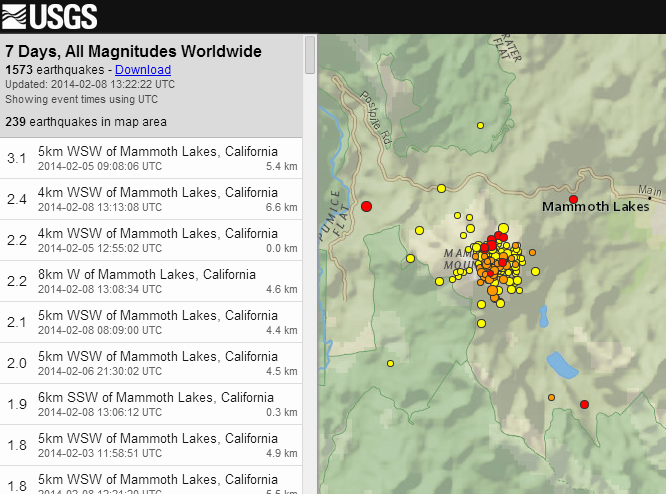
And we got us a rapid fire swarm under Mammoth Mountain at LV going on now. It appears persistent. What you are seeing reported on USGS is only a
fraction of the quakes that are happening- remember they only report the biggest ones. Seems to have been spurred on by the 2.7. Some of those are
pretty darn shallow. Hope that ain't a new intrusion... Got to crash... Keep an eye on this, peoples. Please?
Here is a link to current LV activity.
Volcano Webcams
Scroll down to choose the Long Valley volcano. More info there on inflation and deformation

Volcano Webcams
Scroll down to choose the Long Valley volcano. More info there on inflation and deformation
Great read. I had no idea how underappreciated these guys were only 30-40 years ago. Their work is so specialized and thankfully...today - they're
widely appreciated.
I was in the zone of Mt St Helens and recall having to stay indoors for 2-weeks - only going outdoors if your nose/mouth were covered, and absolutely necessary.
All volcanoes are connected to the mantle so what makes only a couple take the pressure - what made Mt St Helens take it in 1980? Whatever it is let's hope these smaller ones continue to be the primary outlet - with North American super volcanoes being the path of the most resistance.
Thanks for the information.
edit on 5-2-2014 by Dianec because: (no reason given)
reply to post by TrueAmerican
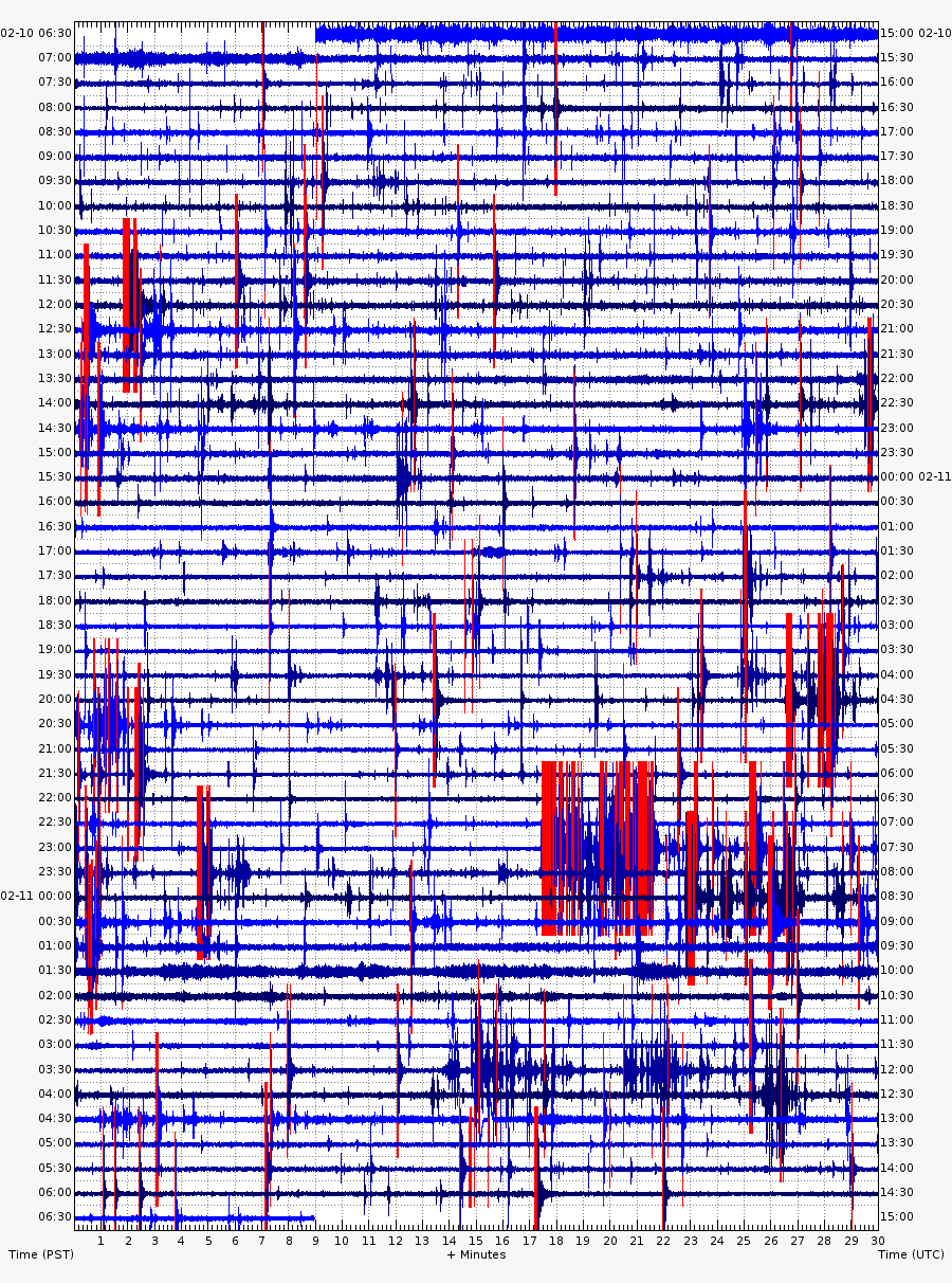
Mammoth is still percolating...
The last few minutes show quite the outburst. This link is to a few Long Valley spectrograms. (not real-time--a 10-15 minute delay).
Could be another dike intrusion.
Mammoth is still percolating...
The last few minutes show quite the outburst. This link is to a few Long Valley spectrograms. (not real-time--a 10-15 minute delay).
Could be another dike intrusion.
CalVO (the California Volcano Observatory) issued a statement on 6 Feb 2014, concerning the current activity.
Link
Here is an interesting tidbit:
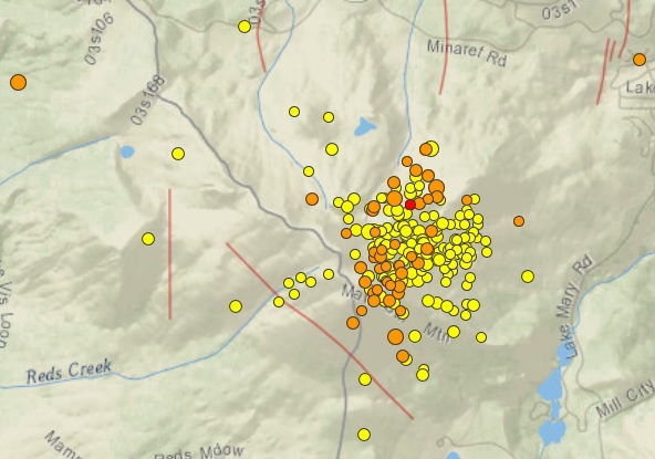
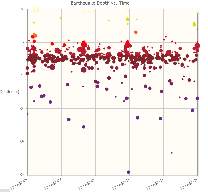
This image shows the last 3 months of activity under Mammoth Mountain. source
This swarm/spasmodic burst has their attention. I'd love to know if the gas emissions have increased. The timing is crap. I think the Sierras are finally getting some snow--the locals will be outraged if (big "if" at this early stage) they are told to shut down operations.
Here is an interesting tidbit:
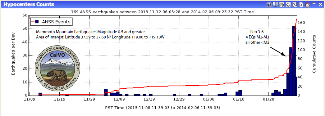
Earthquake swarms, including spasmodic bursts, occur periodically beneath Mammoth Mountain. The current swarm is notable, however, because it includes the largest magnitude event (M3.0) observed in ~15 years.
This image shows the last 3 months of activity under Mammoth Mountain. source
This swarm/spasmodic burst has their attention. I'd love to know if the gas emissions have increased. The timing is crap. I think the Sierras are finally getting some snow--the locals will be outraged if (big "if" at this early stage) they are told to shut down operations.
edit on
2/8/2014 by Olivine because: (no reason given)
reply to post by Olivine
lol, I don't think it will come to that, Oli, unless things got really bad again. And even then, the tolerance for severe symptoms is so high at LV, they'd probably have to see intense harmonic tremor before they'd make any calls.
In comparison, this is nothing compared to what went on there in the 80's-90's. But still, it is always highly interesting to me to watch it. Now that you guys can see more of the now posted microquakes that happened, maybe you can understand my initial excitement from a previous post when the rapid fire events started happening. I will confess it got to the point after a couple of hours of persistence that I did fire off an email asking for further vigilance, as I had to go to bed. And then poof, it died down, as I found out the following day. Typical LV. Thanks for the contributions, Oli. You truly are a cut above.
And here is the swarm after 7 days:
Pretty good little rockin at Mammoth.
edit on Sat Feb 8th 2014 by TrueAmerican because: (no reason given)
Interesting thread, TA! I always love learning something new and discovering that Mammoth Mountain is not dormant is quite new to me. Given that the
last eruption was somewhere along the lines of 50,000 years ago, I would say that this activity is fairly inert since for all we know this is very
common to it. But, I must ask, what would be the implications of this erupting? Are we talking an impact in areas directly east up to a certain
localized distance (depending on the wind) and nothing more? Or are we talking about widespread impact?
Again, it is clear that the chances of this happening in our lifetime is very slim, but it would satisfy my curiosity to hear some of the more knowledgeable folks here chime in on their opinions of what an eruption would be like.
Again, it is clear that the chances of this happening in our lifetime is very slim, but it would satisfy my curiosity to hear some of the more knowledgeable folks here chime in on their opinions of what an eruption would be like.
reply to post by nydsdan
For small to mid-size eruptions, we'd most likely see this:
volcanoes.usgs.gov...
It is highly dependent on the wind speed and direction at the time of the eruption. From the articles, it would most likely migrate in an easterly direction, as the wind blows there in an easterly direction 80% of the time.
But caution. That is for a mere one cubic kilometer of eruptive volume. There is a reason LV is considered a supervolcano. It has erupted over 1,000 cubic kilometers in the past, or so they think from ash deposits. A caldera forming eruption there (unlikely) would be devastating, and probably cover WAY more area than what you see on that map. Combine that with it erupting big during the 20% of the time the wind is blowing west, and you'd have some serious disaster soup.
I'd like to think we'd have a better chance of winning the lottery. Of course, mother nature doesn't care what we think. The Japan 9+ in the unlikely spot showed that loud and clear.
reply to post by Olivine
Yes, station MMP is just one of the many at LV entertaining my screen.
And the rapid fire seismicity is entertaining. I just watch to make sure that LP events and tremor don't turn this into a horror show real quick like.
Yes, station MMP is just one of the many at LV entertaining my screen.
And the rapid fire seismicity is entertaining. I just watch to make sure that LP events and tremor don't turn this into a horror show real quick like.
As the swarm continues under Mammoth Mountain, which, by the way, is a resurgent dome- I found it curious that around the dome itself there doesn't
appear to be much recent ground uplift.
But in the middle of the caldera, to the right of Mammoth, however, I have found quite a few GPS stations that are showing uplift since about 2011. And in a few cases, some pretty sharp upward trends. Take a look:
earthquake.usgs.gov...
I remember some comments from Jake Lowenstern at Yellowstone mentioning that as they study these huge calderas- one thing is becoming apparent: that earthquakes will frequently happen coinciding with ground subsidence- as opposed to uplift. It's almost as if the quakes themselves relieve the upward pressure from the magma chamber.
Still, if we were to see the same type of activity under one of the Yellowstone resurgent domes, either Sour Creek or Mallard Lake, I imagine that would make more than a few people pretty nervous. Jake said it was a "nervous time" back in 2008 when that massive swarm hit in Yellowstone Lake, cause no one can see under water- and of course- the infamous bulge is under there. And that swarm moved directly towards it, and then under it.
If we were to see the kind of very intense activity that happened at LV back in the 80's, but at one of the YS domes, umm, yeah, yours truly here would just about freak out.
reply to post by TrueAmerican
This swarm is showing some persistence. It also seems to be spreading out a bit in the past hour, and the hypocenters look a touch more shallow.
Here is the past 24 hours courtesy of USGS.
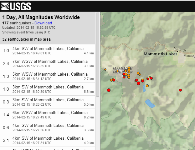
This image from CalVO I have set to show the past 10 days--since the Mag 3.0 that kicked this off. 484 small quakes over that time.
This swarm is showing some persistence. It also seems to be spreading out a bit in the past hour, and the hypocenters look a touch more shallow.
Here is the past 24 hours courtesy of USGS.
This image from CalVO I have set to show the past 10 days--since the Mag 3.0 that kicked this off. 484 small quakes over that time.
new topics
-
Sunak spinning the sickness figures
Other Current Events: 28 minutes ago -
Nearly 70% Of Americans Want Talks To End War In Ukraine
Political Issues: 39 minutes ago -
Late Night with the Devil - a really good unusual modern horror film.
Movies: 2 hours ago -
Cats Used as Live Bait to Train Ferocious Pitbulls in Illegal NYC Dogfighting
Social Issues and Civil Unrest: 3 hours ago -
The Good News According to Jesus - Episode 1
Religion, Faith, And Theology: 5 hours ago -
HORRIBLE !! Russian Soldier Drinking Own Urine To Survive In Battle
World War Three: 7 hours ago -
Bobiverse
Fantasy & Science Fiction: 10 hours ago -
Florida man's trip overseas ends in shock over $143,000 T-Mobile phone bill
Social Issues and Civil Unrest: 10 hours ago
top topics
-
Florida man's trip overseas ends in shock over $143,000 T-Mobile phone bill
Social Issues and Civil Unrest: 10 hours ago, 8 flags -
SETI chief says US has no evidence for alien technology. 'And we never have'
Aliens and UFOs: 14 hours ago, 7 flags -
Cats Used as Live Bait to Train Ferocious Pitbulls in Illegal NYC Dogfighting
Social Issues and Civil Unrest: 3 hours ago, 7 flags -
This is our Story
General Entertainment: 17 hours ago, 4 flags -
Former Labour minister Frank Field dies aged 81
People: 13 hours ago, 4 flags -
Bobiverse
Fantasy & Science Fiction: 10 hours ago, 3 flags -
Late Night with the Devil - a really good unusual modern horror film.
Movies: 2 hours ago, 2 flags -
HORRIBLE !! Russian Soldier Drinking Own Urine To Survive In Battle
World War Three: 7 hours ago, 2 flags -
The Good News According to Jesus - Episode 1
Religion, Faith, And Theology: 5 hours ago, 0 flags -
Nearly 70% Of Americans Want Talks To End War In Ukraine
Political Issues: 39 minutes ago, 0 flags
active topics
-
Breaking Baltimore, ship brings down bridge, mass casualties
Other Current Events • 482 • : IndieA -
Nearly 70% Of Americans Want Talks To End War In Ukraine
Political Issues • 3 • : Irishhaf -
President BIDEN Vows to Make Americans Pay More Federal Taxes in 2025 - Political Suicide.
2024 Elections • 113 • : Zanti Misfit -
How ageing is" immune deficiency"
Medical Issues & Conspiracies • 30 • : annonentity -
Remember These Attacks When President Trump 2.0 Retribution-Justice Commences.
2024 Elections • 55 • : Zanti Misfit -
SETI chief says US has no evidence for alien technology. 'And we never have'
Aliens and UFOs • 36 • : anthelion -
Truth Social goes public, be careful not to lose your money
Mainstream News • 124 • : lilzazz -
British TV Presenter Refuses To Use Guest's Preferred Pronouns
Education and Media • 145 • : Annee -
Sunak spinning the sickness figures
Other Current Events • 0 • : annonentity -
Cats Used as Live Bait to Train Ferocious Pitbulls in Illegal NYC Dogfighting
Social Issues and Civil Unrest • 9 • : ImagoDei