It looks like you're using an Ad Blocker.
Please white-list or disable AboveTopSecret.com in your ad-blocking tool.
Thank you.
Some features of ATS will be disabled while you continue to use an ad-blocker.

Curiosity: Potential Anomalies (Update 01/2014)
page: 27share:
reply to post by Aleister
me ? a t&c violation , never ,
*funBox radios up to mars control room with a list of the next mildly perverse Martian anomalies*
im glad natural forces have a sence of humour, I nearly brought up the chips I had been eating when I saw last nights rock engorgement, what a hoot
funBox
me ? a t&c violation , never ,
*funBox radios up to mars control room with a list of the next mildly perverse Martian anomalies*
im glad natural forces have a sence of humour, I nearly brought up the chips I had been eating when I saw last nights rock engorgement, what a hoot
funBox
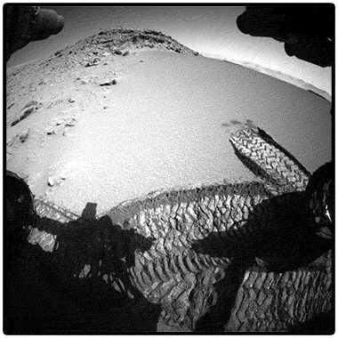
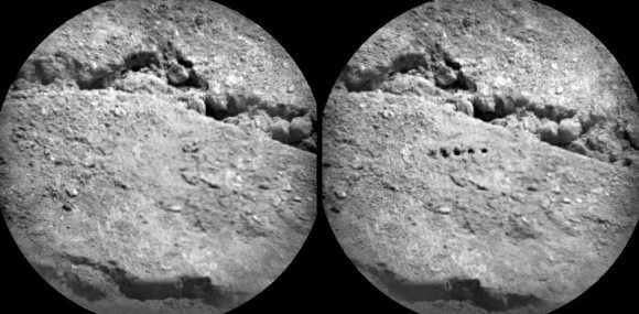
While everyone was looking at rocks, I was looking at this.
What am I looking at here??
At first I thought of some on board experiment,but there are
no signs of tracks from Curiosity going anywhere near this area.
Let the speculation begin.


What am I looking at here??
At first I thought of some on board experiment,but there are
no signs of tracks from Curiosity going anywhere near this area.
Let the speculation begin.
edit on 1-2-2014 by mark1167 because: spelling
edit on 1-2-2014 by mark1167 because: add
reply to post by mark1167
To clarify a bit: Who took this picture?
www.nasa.gov...
You are looking at composited images. Your next assignment is to abandon the composite and find the source images before proclaiming that there are no signs of tracks.
At first I thought of some on board experiment,but there are no signs of tracks from Curiosity going anywhere near this area.
To clarify a bit: Who took this picture?
www.nasa.gov...
edit on 2/1/2014 by Phage because: (no reason given)
reply to post by Phage
Its simple really, NASA packed a mirror with it so it could take selfies on mars...
Actually, this article has a video that they claim how it was done.
news.nationalgeographic.com...
Its simple really, NASA packed a mirror with it so it could take selfies on mars...
Actually, this article has a video that they claim how it was done.
news.nationalgeographic.com...
reply to post by mark1167
I was first looking at the Pizza box at the right.. But then I scrolled further.. Brilliant find!
I have no clue what it could be...
I was first looking at the Pizza box at the right.. But then I scrolled further.. Brilliant find!
I have no clue what it could be...
reply to post by mark1167
they look like something casued by the drill bit or laser, hmmm
was looking back to sol 518 , mardi took an upside down pic, does anyone else notice the swarm of dust in the sky , or do I need to clean my monitor?
mardi sol 518
a gif showing extent of the tool arm
funBox
they look like something casued by the drill bit or laser, hmmm
was looking back to sol 518 , mardi took an upside down pic, does anyone else notice the swarm of dust in the sky , or do I need to clean my monitor?
mardi sol 518
a gif showing extent of the tool arm
funBox
edit on 1-2-2014 by funbox because: of ed-209 enraged riding wolves
reply to post by mark1167
As funbox said, it's the result of an experiment with the laser, I remember seeing that photo when they did it, and as phage said, we don't see any signs of the rover being close to that area because that image is a mosaic made with several photos.
As funbox said, it's the result of an experiment with the laser, I remember seeing that photo when they did it, and as phage said, we don't see any signs of the rover being close to that area because that image is a mosaic made with several photos.
edit on 1/2/2014 by ArMaP
because: (no reason given)
mark1167
While everyone was looking at rocks, I was looking at this.
What am I looking at here??
At first I thought of some on board experiment,but there are
no signs of tracks from Curiosity going anywhere near this area.
Let the speculation begin.
If you are talking about the holes, there is no speculation necessary...they were made by Curiosity's ChemCam Laser. The laser can shoot several meters, so you would not necessarily see any wheel tracks leading to those spots.
Here is an article about other laser blasts from Curiosity:
Curiosity’s Laser Leaves Its Mark
Thanks to everyone for clearing that up.
I can always count on you guys for a reality check.
I can always count on you guys for a reality check.
reply to post by jeep3r
Seemingly geological(?) in nature, but IMO still distinctive enough to be posted ... here's a close-up of some interesting rectangular formations at Dingo Gap:
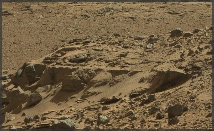
And some straight/bent grooves and striations (layers?) on top of this formation:
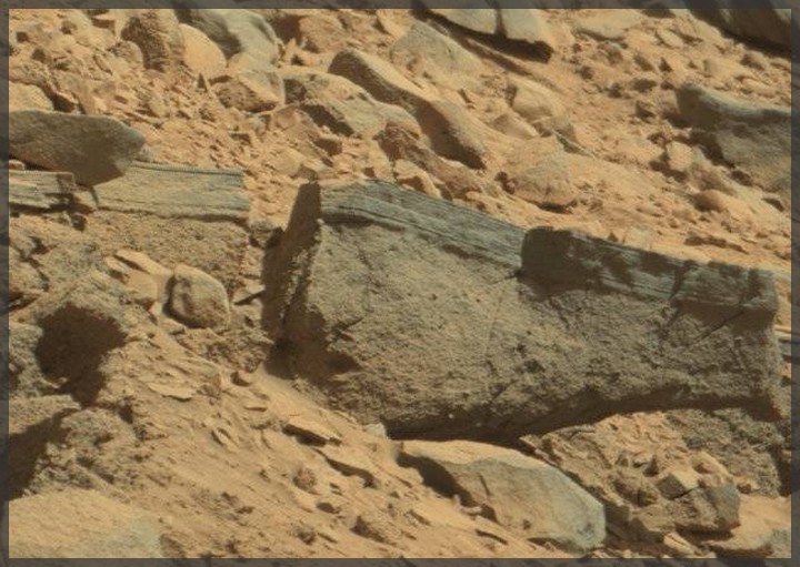
Does anybody on here know how geologists would call such striations/formations as seen in the image above? Thanks in advance for any thoughts on this ... !
SOURCES:
------------
1. NASA/JPL Image Link 1
2. NASA/JPL Image Link 2
3. Sol 529 Panorama (MastCam100)
Seemingly geological(?) in nature, but IMO still distinctive enough to be posted ... here's a close-up of some interesting rectangular formations at Dingo Gap:
And some straight/bent grooves and striations (layers?) on top of this formation:
Does anybody on here know how geologists would call such striations/formations as seen in the image above? Thanks in advance for any thoughts on this ... !
SOURCES:
------------
1. NASA/JPL Image Link 1
2. NASA/JPL Image Link 2
3. Sol 529 Panorama (MastCam100)
edit on 2-2-2014 by
jeep3r because: text
reply to post by jeep3r
Good pictures, the Rover is traveling in an interesting area. I'm not a geologist (but I did once play one on the radio, or was that a gynecologist?) but they look like strata. Could they have been formed when Gale Lake dried, then filled again? Sand strata? Just a guess, but maybe it's time to call the ATS geologist in for a look at those and maybe Buzz's first large spoke objects(s).
Good pictures, the Rover is traveling in an interesting area. I'm not a geologist (but I did once play one on the radio, or was that a gynecologist?) but they look like strata. Could they have been formed when Gale Lake dried, then filled again? Sand strata? Just a guess, but maybe it's time to call the ATS geologist in for a look at those and maybe Buzz's first large spoke objects(s).
reply to post by jeep3r
That's why I said I was hoping they would choose that path, it's much more interesting from a geological point of view, as all those layers represent different stages of the "life" of lake.
That thin, darker layer looks like silt, for example.
That's why I said I was hoping they would choose that path, it's much more interesting from a geological point of view, as all those layers represent different stages of the "life" of lake.
That thin, darker layer looks like silt, for example.
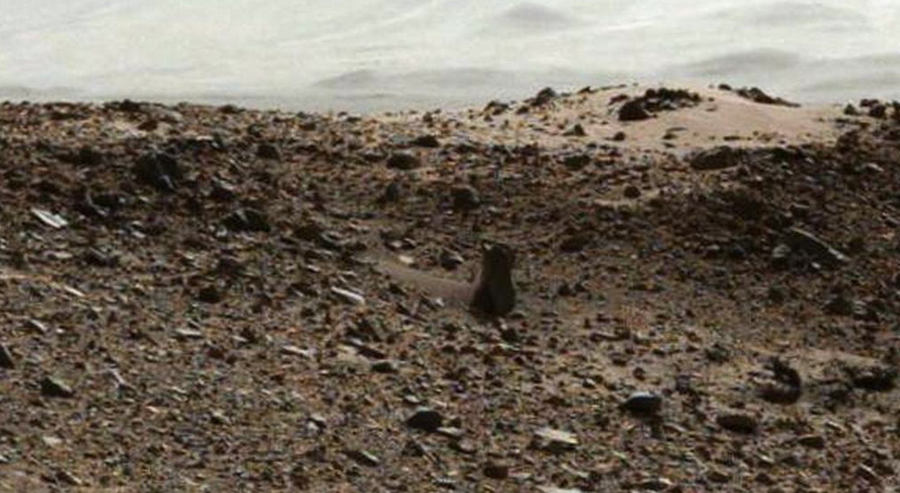
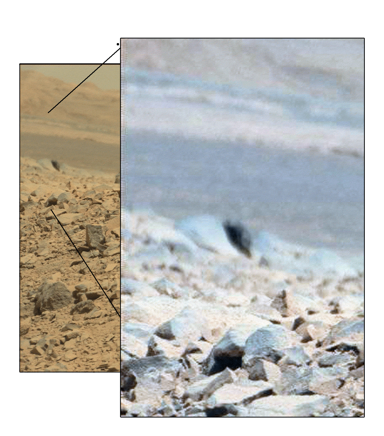
Since this is a catch-all thread, with links to other threads as well, here is a new one about the standing object that funbox linked a video about
earlier. They call it a leg, the guy in the video called it a water pipe with a handle, and we like to call it a rock. The thread here:
www.abovetopsecret.com...
www.abovetopsecret.com...
edit on 2-2-2014 by Aleister because: (no reason given)
ArMaP
reply to post by jeep3r
That's why I said I was hoping they would choose that path, it's much more interesting from a geological point of view, as all those layers represent different stages of the "life" of lake.
That thin, darker layer looks like silt, for example.
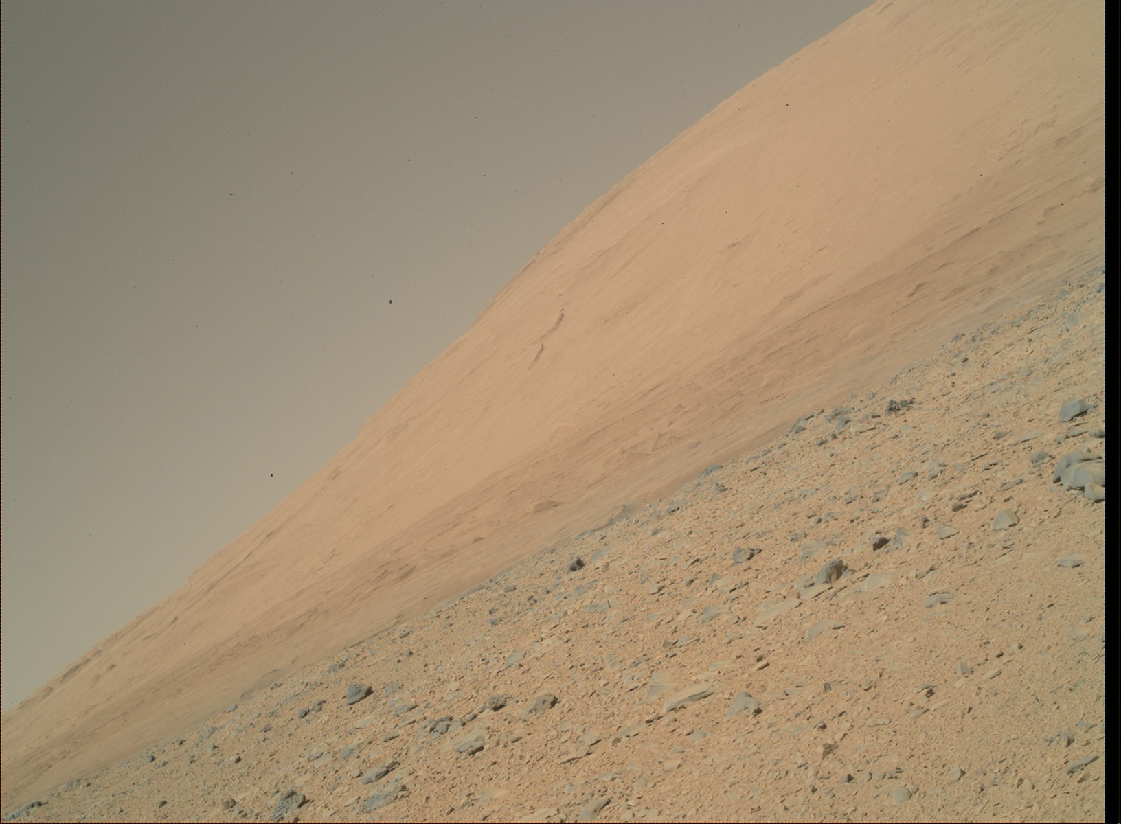
I also think the team wants to use the dune at Dingo Gap as a testbed for 'smooth roving', in terms of checking how Curiosity's deteriorating wheels do on sand and smoother ground. Depending on the outcome, that experience might alter the route towards the base of Mt. Sharp/Aeolis.
Of course they wouldn't want to risk getting stuck in the sand (like 'Spirit' a while back), but perhaps they'll choose to avoid terrain that's too rocky, in favor of keeping the wheels 'operational'.
reply to post by jeep3r
Wouldn't they know how it holds up on deep sand, from earth experiments, or do you mean the wheels are so bad now that chancy maneuvers have to be undertaken to get to the base of the Mount? Are you saying that they may not go to Murray Buttes, but try to cross the sand? Are the wheels that bad (I haven't kept track of the major concerns). Thanks.
Wouldn't they know how it holds up on deep sand, from earth experiments, or do you mean the wheels are so bad now that chancy maneuvers have to be undertaken to get to the base of the Mount? Are you saying that they may not go to Murray Buttes, but try to cross the sand? Are the wheels that bad (I haven't kept track of the major concerns). Thanks.
edit on 2-2-2014 by Aleister because: (no reason given)
reply to post by Aleister
I read about it on space.com, here goes a short excerpt:
That area is obviously very interesting from a geological point of view. But it also looks as if they are trying to check the ground consistency of dunes, like Dingo Gap, "in-situ" so to speak ... but I can't really imagine they'd send Curiosity across larger dune fields just to reach Mt. Sharp faster and with less wheel damage. Ultimately, we'll have to wait and see what solutions theirs engineers come up with.
ETA: Perhaps they're just trying this 'once' to get Curiosity beyond Dingo Gap, in order to not have to steer her around those (much more rocky) outcrops towards the western part of that formation.
I read about it on space.com, here goes a short excerpt:
NASA's Curiosity Rover Seeks Smoother Road to Reduce Wheel Damage
Curiosity's handlers are driving the 1-ton rover more cautiously now and are checking the condition of its wheels frequently, NASA officials said. The rover team is also considering sending Curiosity over a 3-foot-tall (1 meter) sand dune soon to access a potentially smoother, less rocky route to its ultimate science destination, the foothills of the towering Mount Sharp.
That area is obviously very interesting from a geological point of view. But it also looks as if they are trying to check the ground consistency of dunes, like Dingo Gap, "in-situ" so to speak ... but I can't really imagine they'd send Curiosity across larger dune fields just to reach Mt. Sharp faster and with less wheel damage. Ultimately, we'll have to wait and see what solutions theirs engineers come up with.
ETA: Perhaps they're just trying this 'once' to get Curiosity beyond Dingo Gap, in order to not have to steer her around those (much more rocky) outcrops towards the western part of that formation.
edit on 2-2-2014 by jeep3r because: text
reply to post by Aleister
if they try to get across around this area dingo grove? they might be able to get a closer image of blueshe its house
would like to have some different focus for these shots, the background looks amazing
sol
sol
@jeep3r is that an asphalt layer? on hardcore?
funBox
if they try to get across around this area dingo grove? they might be able to get a closer image of blueshe its house
would like to have some different focus for these shots, the background looks amazing
sol
sol
@jeep3r is that an asphalt layer? on hardcore?
funBox
edit on 2-2-2014 by funbox because: link fix
edit on 2-2-2014 by funbox because: (no reason given)
funbox
@jeep3r is that an asphalt layer? on hardcore?
Asphalt? In combination with "BlueIt" and that accident on a cliff? Would make kinda sense, wouldn't it?
reply to post by jeep3r
defiantly. you can't expect the poor little blighters to walk now can you , I can imagine a troop on the back of a wagon , racing off to fix the crappy potholes that crop up every Martian winter and cause nasty accidents like on that cliff
did that picture I posted, the one covered in black dots have a thread all to itself?
funBox
new topics
-
Predicting The Future: The Satanic Temple v. Florida
Conspiracies in Religions: 22 seconds ago -
WF Killer Patents & Secret Science Vol. 1 | Free Energy & Anti-Gravity Cover-Ups
General Conspiracies: 2 hours ago -
Hurt my hip; should I go see a Doctor
General Chit Chat: 2 hours ago -
Israel attacking Iran again.
Middle East Issues: 4 hours ago -
Michigan school district cancels lesson on gender identity and pronouns after backlash
Education and Media: 4 hours ago -
When an Angel gets his or her wings
Religion, Faith, And Theology: 4 hours ago -
Comparing the theology of Paul and Hebrews
Religion, Faith, And Theology: 5 hours ago -
Pentagon acknowledges secret UFO project, the Kona Blue program | Vargas Reports
Aliens and UFOs: 6 hours ago -
Boston Dynamics say Farewell to Atlas
Science & Technology: 6 hours ago -
I hate dreaming
Rant: 7 hours ago
top topics
-
The Democrats Take Control the House - Look what happened while you were sleeping
US Political Madness: 10 hours ago, 18 flags -
In an Historic First, In N Out Burger Permanently Closes a Location
Mainstream News: 12 hours ago, 16 flags -
A man of the people
Medical Issues & Conspiracies: 17 hours ago, 11 flags -
Man sets himself on fire outside Donald Trump trial
Mainstream News: 9 hours ago, 9 flags -
Biden says little kids flip him the bird all the time.
Politicians & People: 9 hours ago, 9 flags -
Pentagon acknowledges secret UFO project, the Kona Blue program | Vargas Reports
Aliens and UFOs: 6 hours ago, 6 flags -
Michigan school district cancels lesson on gender identity and pronouns after backlash
Education and Media: 4 hours ago, 6 flags -
WF Killer Patents & Secret Science Vol. 1 | Free Energy & Anti-Gravity Cover-Ups
General Conspiracies: 2 hours ago, 6 flags -
Israel attacking Iran again.
Middle East Issues: 4 hours ago, 5 flags -
Boston Dynamics say Farewell to Atlas
Science & Technology: 6 hours ago, 4 flags
active topics
-
Predicting The Future: The Satanic Temple v. Florida
Conspiracies in Religions • 0 • : Degradation33 -
A man of the people
Medical Issues & Conspiracies • 15 • : PrivateAngel -
Israel attacking Iran again.
Middle East Issues • 27 • : KrustyKrab -
I hate dreaming
Rant • 7 • : TheMichiganSwampBuck -
MULTIPLE SKYMASTER MESSAGES GOING OUT
World War Three • 53 • : Zaphod58 -
Michigan school district cancels lesson on gender identity and pronouns after backlash
Education and Media • 8 • : TheMichiganSwampBuck -
I Guess Cloud Seeding Works
Fragile Earth • 29 • : Justoneman -
Man sets himself on fire outside Donald Trump trial
Mainstream News • 40 • : Vermilion -
When an Angel gets his or her wings
Religion, Faith, And Theology • 5 • : randomuser2034 -
Anyone one else having Youtube problems
Computer Help • 11 • : charlyv