It looks like you're using an Ad Blocker.
Please white-list or disable AboveTopSecret.com in your ad-blocking tool.
Thank you.
Some features of ATS will be disabled while you continue to use an ad-blocker.

Quake Watch 2014
page: 96share:
M 3.1 - 36km WNW of West Yellowstone, Montana
DYFI? - IV
Time
2014-10-27 03:35:21 UTC-07:00
Location
44.819°N 111.503°W
Depth
9.8km
M 3.0 - 29km W of Waldport, Oregon
ShakeMap - IIIDYFI? - I
Time
2014-10-27 00:41:41 UTC-07:00
Location
44.374°N 124.435°W
Depth
30.0km
earthquake.usgs.gov...
DYFI? - IV
Time
2014-10-27 03:35:21 UTC-07:00
Location
44.819°N 111.503°W
Depth
9.8km
M 3.0 - 29km W of Waldport, Oregon
ShakeMap - IIIDYFI? - I
Time
2014-10-27 00:41:41 UTC-07:00
Location
44.374°N 124.435°W
Depth
30.0km
earthquake.usgs.gov...
Had a dream last night we got hit by a massive earthquake, it wasn't the usual noisy shaking rattling swaying rolling type,
more a incredible shuddering, like a giant bulldozer was pushing the house along the ground, like we were right on top of the epicenter. Yikes.
more a incredible shuddering, like a giant bulldozer was pushing the house along the ground, like we were right on top of the epicenter. Yikes.
originally posted by: muzzy
Had a dream last night we got hit by a massive earthquake, it wasn't the usual noisy shaking rattling swaying rolling type,
more a incredible shuddering, like a giant bulldozer was pushing the house along the ground, like we were right on top of the epicenter. Yikes.
You breath EQs, you eat EQ's You spend your spare time on EQs.
I am surprised this is the first dream you have mentioned.
Perhaps your subconscious is trying to tell you something.
Take a break, smell some flowers, it is spring after all.
P
This one seems only to be a Mag 6+ for USGS
Location in Google Maps
Derived from Event Data Source: USGS
Powered by QVSData
Did no one else see it or did I miss it being posted?
Magnitude 6.1 - Tonga Islands (173)
Location in Google Maps
- Date-Time: Tuesday, October 28, 2014 @ 03:15:43 UTC
- Earthquake location: 15.193°S, 174.666°W,
- Earthquake depth: 35.0 km
- Distances:
129km (80mi) NW of Hihifo, Tonga
346km (214mi) WSW of Apia, Samoa
435km (270mi) WSW of Tafuna, American Samoa
438km (272mi) WSW of Pago Pago, American Samoa
651km (404mi) E of Lambasa, Fiji
- Event ID: usb000sr1a
Derived from Event Data Source: USGS
Powered by QVSData
Did no one else see it or did I miss it being posted?
a reply to: pheonix358
Meh!! Only for you and Muzzy and other underside beings. For us topsiders it is heading into winter, the flowers are fading and the expected winter earthquake show seems to be slow in getting started.
So glad I don't remember my dreams (I assume I have them)
it is spring after all.
Meh!! Only for you and Muzzy and other underside beings. For us topsiders it is heading into winter, the flowers are fading and the expected winter earthquake show seems to be slow in getting started.
So glad I don't remember my dreams (I assume I have them)
a reply to: PuterMan
I hear ya now, but was asleep when you posted. I know the feeling when no one replies.
Seen that last night and thought it might go up, having looked at LISS SNZO and some of the other graphs
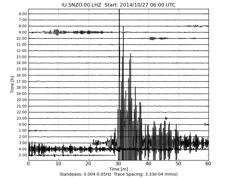
for those that don't have the link, it's still showing on LISS, will disappear in 10 hours
I hear ya now, but was asleep when you posted. I know the feeling when no one replies.
Seen that last night and thought it might go up, having looked at LISS SNZO and some of the other graphs
for those that don't have the link, it's still showing on LISS, will disappear in 10 hours
originally posted by: pheonix358
You breath EQs, you eat EQ's You spend your spare time on EQs.
I am surprised this is the first dream you have mentioned.
Perhaps your subconscious is trying to tell you something.
Take a break, smell some flowers, it is spring after all.
P
that bad eh?
It may seem that way, but most of the EQ stuff I do is done in one hour a day, usually when I get home from work while my talented wife cooks dinner. Other times it does give me something to do while its raining or too windy to work, or if there is a big event worth following up on. I used to go to the Pub and drink beer.
Its actually the mapping that interest's me most, always looking for improvements.
Sure we do get some decent quakes here where I live, and always the threat of the M8 on the other coast, that keeps me checking the data.
I don't remember dreams that much. At least 3 times I have woke up thinking it was a dream, but it was real, M6's going off.
Spring sux, basically cold, rain and wind here. Summer and Autumn are the best seasons.
M3.6 - 2km NNW of The Geysers, California
2014-10-29 04:36:35 UTC
Event Time
2014-10-29 04:36:35 UTC
2014-10-28 21:36:35 UTC-07:00 at epicenter
2014-10-28 21:36:35 UTC-07:00 system time
Location
38.801°N 122.770°W depth=1.9km (1.2mi)
earthquake.usgs.gov...
2014-10-29 04:36:35 UTC
Event Time
2014-10-29 04:36:35 UTC
2014-10-28 21:36:35 UTC-07:00 at epicenter
2014-10-28 21:36:35 UTC-07:00 system time
Location
38.801°N 122.770°W depth=1.9km (1.2mi)
earthquake.usgs.gov...
a reply to: muzzy
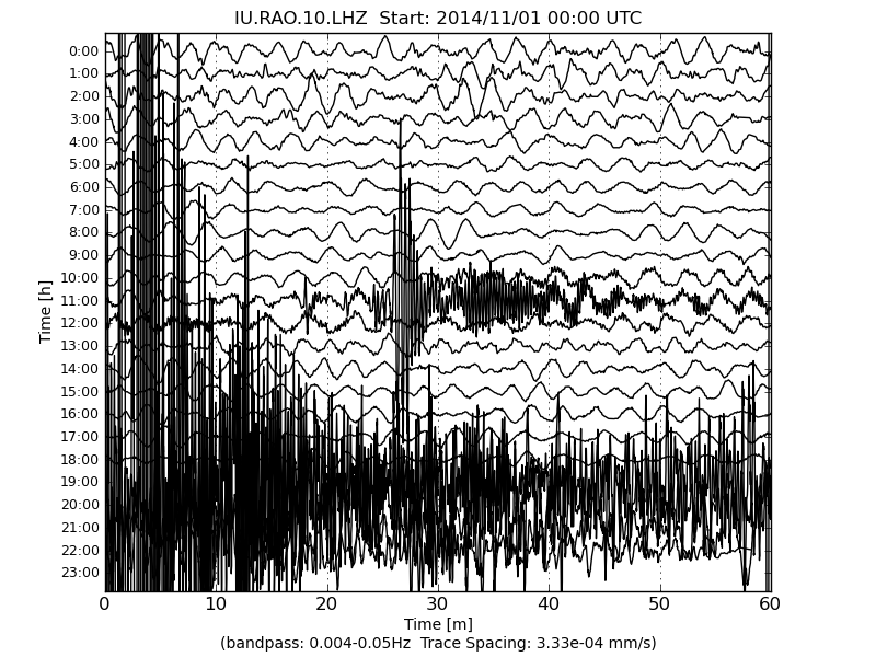
Talking about LISS, this one caught my eye today.
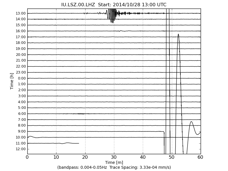
Click the image to enlarge
Looks like a local quake from the signature. Teleseisms appear like the top one usually. Nothing showing in the listings.
PS Just a reminder to QVSData users that all versions have the LISS images built in to the Webicorder viewer
a reply to: PuterMan
yeah that's a strange one, looks weird on IRIS LSZ, with a looped hook trace after the P wave
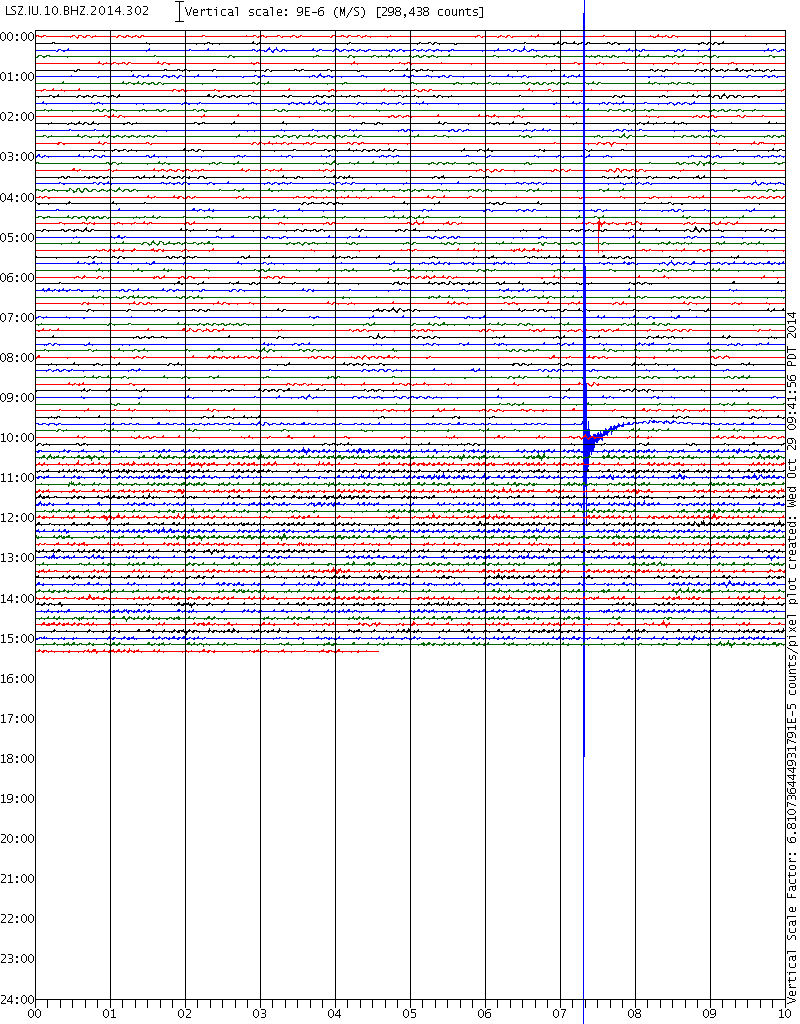
www.iris.edu...
bit of a trace on MBAR in Mbarara, Uganda, 1650km away
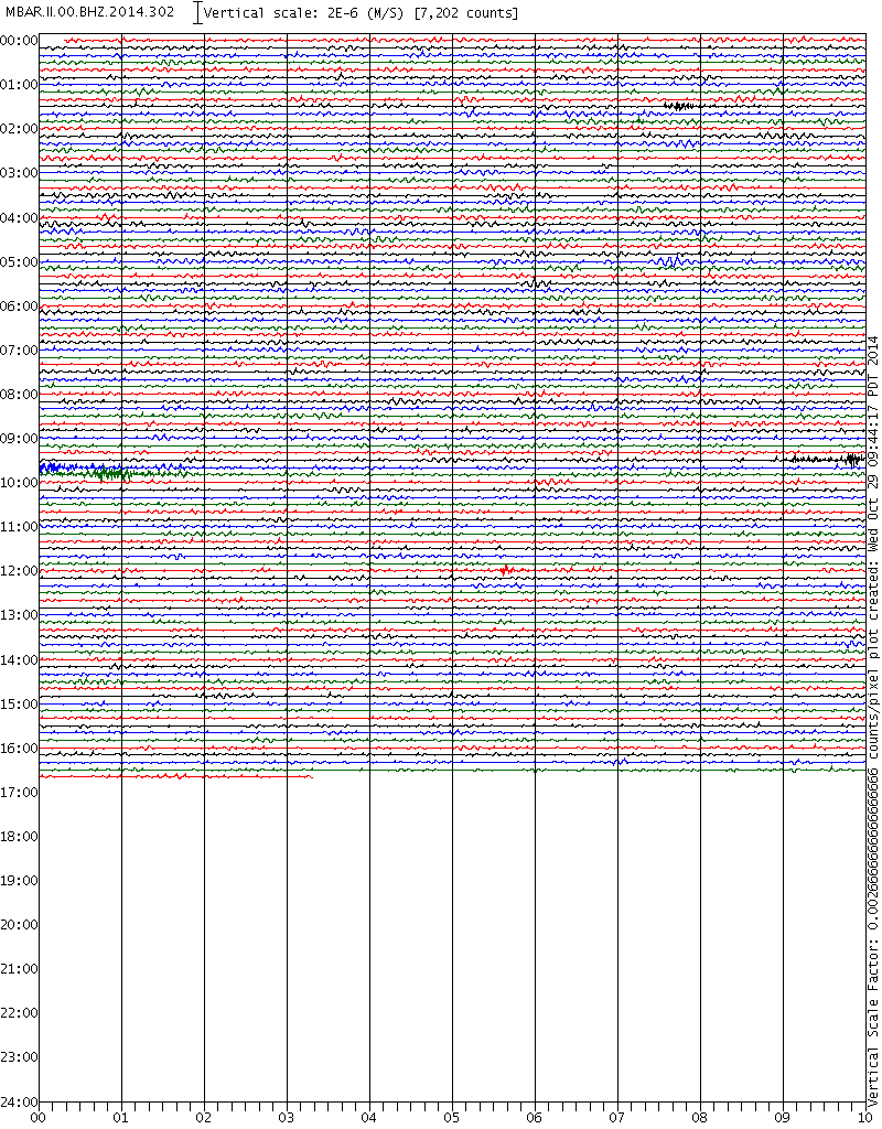
www.iris.edu...
rightclick"viewimage"forfullsizes
links good for 15 days
yeah that's a strange one, looks weird on IRIS LSZ, with a looped hook trace after the P wave
www.iris.edu...
bit of a trace on MBAR in Mbarara, Uganda, 1650km away
www.iris.edu...
rightclick"viewimage"forfullsizes
links good for 15 days
edit on 10u30130114 by muzzy because: (no reason given)
Magnitude 6.0 - Easter Island Region (685)
Location in Google Maps
- Date-Time: Saturday, November 01, 2014 @ 10:59:55 UTC
- Earthquake location: 31.823°S, 111.180°W,
- Earthquake depth: 10.0 km
- Distances:
544km (338mi) SSW of Hanga Roa, Chile
3473km (2158mi) W of Lebu, Chile
3482km (2163mi) W of Ancud, Chile
3492km (2169mi) W of Chonchi, Chile
1995km (1239mi) ESE of Adamstown, Pitcairn
- Event ID: usc000stbw
Derived from Event Data Source: USGS
Powered by QVSData
a reply to: muzzy
Thanks for digging out those,but is the MBAR one the same? The IU.LSZ event is ~10:27:20 and the long II.MBAR event starts about 09:39 and
nothing else is visible until ~12:05:40 (very small red mark) unless I am reading it wrong.
I am reading it wrong! You are correct.
Scrub my previous comment.
Just noticed the wave on the LISS chart starts ~09:47 which is does match the IRIS chart event on BHZ. The MBAR event at 09:39 is followed by one at about 09:50:35 (green line) which would seem to be possibly a response to the Lusaka event. The LHZ channel (good for about 12 days) seems to be the one that generated the LISS event.
The BHZ event you found must be VERY local and is not mentioned anywhere that I can find. I think the MBAR event is looking at a teleseism before that and of that (the two traces)
According to weather.co.zw the last earthquake was 2011 !!
Thanks for digging out those,
I am reading it wrong! You are correct.
Scrub my previous comment.
Just noticed the wave on the LISS chart starts ~09:47 which is does match the IRIS chart event on BHZ. The MBAR event at 09:39 is followed by one at about 09:50:35 (green line) which would seem to be possibly a response to the Lusaka event. The LHZ channel (good for about 12 days) seems to be the one that generated the LISS event.
The BHZ event you found must be VERY local and is not mentioned anywhere that I can find. I think the MBAR event is looking at a teleseism before that and of that (the two traces)
According to weather.co.zw the last earthquake was 2011 !!
edit on 1/11/2014 by PuterMan because: (no reason given)
Magnitude 6.9 - Fiji Islands Region (181)
Location in Google Maps
- Date-Time: Saturday, November 01, 2014 @ 18:57:22 UTC
- Earthquake location: 19.733°S, 177.750°W,
- Earthquake depth: 416.0 km
- Distances:
142km (88mi) NE of Ndoi Island, Fiji
307km (190mi) WNW of Nuku`alofa, Tonga
438km (272mi) ESE of Suva, Fiji
476km (295mi) SE of Lambasa, Fiji
552km (342mi) ESE of Nadi, Fiji
- Event ID: at00nedjbm
Derived from Event Data Source: USGS
Powered by QVSData
originally posted by: PuterMan
Magnitude 6.9 - Fiji Islands Region (181)
Location in Google Maps
- Date-Time: Saturday, November 01, 2014 @ 18:57:22 UTC
- Earthquake location: 19.733°S, 177.750°W,
- Earthquake depth: 416.0 km
- Distances:
142km (88mi) NE of Ndoi Island, Fiji
307km (190mi) WNW of Nuku`alofa, Tonga
438km (272mi) ESE of Suva, Fiji
476km (295mi) SE of Lambasa, Fiji
552km (342mi) ESE of Nadi, Fiji
- Event ID: at00nedjbm
Derived from Event Data Source: USGS
Powered by QVSData
The USGS has upgraded this one to a 7.1.
Deep for a M7, probably too deep for a Tsunami
via DataPro with added info
Raoul, Kermadecs seems to have the best (biggest) trace
Prov,Date/Time UTC,Latitude,Longitude,Magnitude,Depth(Km),
newz,2014-11-01 18:57:27, -20.352, -176.015, 6.1ML, 467.3
usgs,2014-11-01 18:57:22, -19.698, -177.793, 7.1Mww, 7.2Mwb, 7.1Mwc, 6.9Mi, 434.4
emsc,2014-11-01 18:57:21, -19.650, -177.810, 6.9Mw (was 6.7), 400.0
gfzp,2014-11-01 18:57:21, -19.670, -177.870, 7.0Mw, 409.0
via DataPro with added info
Raoul, Kermadecs seems to have the best (biggest) trace
edit on 11u30430414 by muzzy because: (no reason given)
new topics
-
Happy St George's day you bigots!
Breaking Alternative News: 17 minutes ago -
TLDR post about ATS and why I love it and hope we all stay together somewhere
General Chit Chat: 1 hours ago -
Hate makes for strange bedfellows
US Political Madness: 3 hours ago -
Who guards the guards
US Political Madness: 6 hours ago -
Has Tesla manipulated data logs to cover up auto pilot crash?
Automotive Discussion: 7 hours ago
top topics
-
Hate makes for strange bedfellows
US Political Madness: 3 hours ago, 13 flags -
CIA botched its handling of sexual assault allegations, House intel report says
Breaking Alternative News: 17 hours ago, 11 flags -
whistleblower Captain Bill Uhouse on the Kingman UFO recovery
Aliens and UFOs: 12 hours ago, 10 flags -
Who guards the guards
US Political Madness: 6 hours ago, 10 flags -
1980s Arcade
General Chit Chat: 14 hours ago, 6 flags -
Teenager makes chess history becoming the youngest challenger for the world championship crown
Other Current Events: 16 hours ago, 5 flags -
Deadpool and Wolverine
Movies: 15 hours ago, 4 flags -
TLDR post about ATS and why I love it and hope we all stay together somewhere
General Chit Chat: 1 hours ago, 3 flags -
Has Tesla manipulated data logs to cover up auto pilot crash?
Automotive Discussion: 7 hours ago, 2 flags -
Happy St George's day you bigots!
Breaking Alternative News: 17 minutes ago, 1 flags
active topics
-
Hate makes for strange bedfellows
US Political Madness • 25 • : theatreboy -
Candidate TRUMP Now Has Crazy Judge JUAN MERCHAN After Him - The Stormy Daniels Hush-Money Case.
Political Conspiracies • 696 • : Threadbarer -
Happy St George's day you bigots!
Breaking Alternative News • 6 • : Oldcarpy2 -
Scientists Say Even Insects May Be Sentient
Science & Technology • 56 • : Naftalin -
UN warns Assange may be tortured if extradited to US
Whistle Blowers and Leaked Documents • 14 • : burritocat -
MULTIPLE SKYMASTER MESSAGES GOING OUT
World War Three • 97 • : Oldcarpy2 -
"We're All Hamas" Heard at Columbia University Protests
Social Issues and Civil Unrest • 239 • : network dude -
Mandela Effect - It Happened to Me!
The Gray Area • 113 • : chris_stibrany -
TLDR post about ATS and why I love it and hope we all stay together somewhere
General Chit Chat • 4 • : theatreboy -
1980s Arcade
General Chit Chat • 19 • : theatreboy