It looks like you're using an Ad Blocker.
Please white-list or disable AboveTopSecret.com in your ad-blocking tool.
Thank you.
Some features of ATS will be disabled while you continue to use an ad-blocker.

Quake Watch 2014
page: 94share:
a reply to: Thebel
It was on EMSC,
but they deleted it later
they have even deleted it from their Latest data contributions, look for 09/10/2014 19:15:39 UTC
www.emsc-csem.org...
thats what I said, I was surprised they put it on with only one data provider, from France, and they still have it on
www-dase.cea.fr...
It was on EMSC,
but they deleted it later
they have even deleted it from their Latest data contributions, look for 09/10/2014 19:15:39 UTC
www.emsc-csem.org...
thats what I said, I was surprised they put it on with only one data provider, from France, and they still have it on
www-dase.cea.fr...
This information has not been confirmed by a seismologist, subsequent rectification is therefore likely.
edit on 1000000028428414 by muzzy because: (no reason given)
The song "Okie from Muskogee" keeps popping up in my head.
Looked on USGS. Alittle swarm there too.
Changed my search engine and haven't figured out how to upload sites yet.
Instead of saying properties. It gives me other options and I can't figure out how to do it.
Any help would be appreciated.
Looked on USGS. Alittle swarm there too.
Changed my search engine and haven't figured out how to upload sites yet.
Instead of saying properties. It gives me other options and I can't figure out how to do it.
Any help would be appreciated.
edit on 12-10-2014 by crappiekat because: To add
6.1854 ML quake SW of Fiordland, between Puysegur Bank and Resolution Ridge, dinner time last night
Mw 5.7 [gfz], 5.7 [gcmt]
Mwp: 6.01 [geoau]
Mwb: 5.7 [usgs]
Mwc: 5.7 [gcmt]
Mb: 5.31 [geoau], 5,4 [emsc], 5.8 [gsras]
Ms: 5.54 [geoau], 5.6 [ldeo], 5.3 [gsras], 5.7 [gcmt]
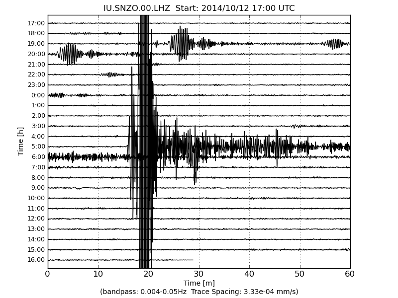
IU/SNZO South Karori, New Zealand
like the All Blacks in South Africa last week and the Sevens in Gold Coast at the weekend, I dropped the ball on this one.
Hadn't done NZ data for a couple of days, didn't see it coming, all the signs were there
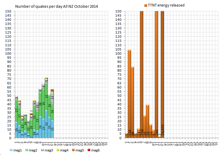
TTNT energy released dropped to a extremely low figure of 2 TTNT on the 12th (muzzy's rule)
there were a couple of foreshocks too, about half an hour before, about 54km to the east towards Solander Island, where most of the aftershocks have been
foreshocks
13/10/2014 04:41:52, -46.373, 166.5849, M3.05
13/10/2014 04:45:46, -46.382, 166.609, M3.14
aftershocks
13/10/2014 05:21:29, -46.3888, 166.6103, 3.57
13/10/2014 05:26:37, -46.3678, 166.6099, 4.39
13/10/2014 05:42:32, -46.5332, 166.5335, 3.13
13/10/2014 06:04:13, -46.3783, 166.6268, 3.75
13/10/2014 06:12:32, -46.2294, 166.6911, 3.63
13/10/2014 06:23:41, -46.395, 166.5014, 4.70
13/10/2014 07:32:20, -46.3873, 166.6175, 3.57
13/10/2014 07:45:24, -46.3791, 166.533, 3.80
13/10/2014 08:50:43, -46.3808, 166.6261, 3.34
13/10/2014 11:01:41, -46.3877, 166.6039, 3.38
13/10/2014 12:53:24, -46.3767, 166.5671, 3.14
13/10/2014 12:59:43, -46.3262, 166.4954, 3.73
Mw 5.7 [gfz], 5.7 [gcmt]
Mwp: 6.01 [geoau]
Mwb: 5.7 [usgs]
Mwc: 5.7 [gcmt]
Mb: 5.31 [geoau], 5,4 [emsc], 5.8 [gsras]
Ms: 5.54 [geoau], 5.6 [ldeo], 5.3 [gsras], 5.7 [gcmt]
Public ID 2014p770859
Intensity severe
Universal Time October 13 2014, 5:13:41
NZ Daylight Time Mon, Oct 13 2014, 6:13:41 pm
Depth 10 km
Magnitude 6.2
Location 140 km west of Tuatapere
Latitude, Longitude -46.29, 165.87
www.geonet.org.nz...
19:53 13/10/2014
A 6.2-magnitude quake rocked parts of the southern South Island when it struck just after 6pm tonight.
GeoNet initially reported the quake occurred about 90km west of Tuatapere,Southland, and was 9km deep and was 5.2.
However, it was revised to 6.2 magnitude, 10km deep, and 140km west of Tuatapere.
It was of severe intensity, GeoNet said.
Emergency Management Southland advisor Jayne McAllister said there was no tsunami risk and no reports of damage.
The quake was felt far and wide, with people in Te Anau, Invercargill, Gore and as far away as Wanaka saying they had felt it.
Southland resident Heather Coles wrote on the Stuff Facebook page that she "certainly did [feel it], chandeliers were swaying and house was shaking near Nightcaps."
Tuatapere Foursquare owner Aaron Challis said he was serving a customer when the quake struck. He described it as a bit of a roll.
"I was sort of holding on to the counter and feeling a bit funny in the old legs.
"Then the lady said 'I think we're having an earthquake', and I looked at the shelves and saw them moving a bit."
Thankfully, there was no damage and nothing fell off the shelves, he said.
"I'm kind of glad nothing fell off the shelves, we've just had them put in - this was a good test for them."
Further away, in Te Anau, residents felt the roll.
Te Anau Freshchoice checkout supervisor Rowena Diculen said customers and staff alike stopped what they were doing when it hit.
All eyes were on the store's signage, which was moving "quite a bit" she said.
Despite the roll, there was no damage and nothing fell off the shelves there either.
www.stuff.co.nz...
F-E Region: Off W. Coast of S. Island, N.Z.
Time: 2014-10-13 05:13:45.8 UTC
Magnitude: 5.7 (Mw)
Epicenter: 166.12°E 46.31°S
Depth: 24 km
Status: M - manually revised
geofon.gfz-potsdam.de...
IU/SNZO South Karori, New Zealand
edit on 10u28528514 by muzzy
because: (no reason given)
edit on 1000000028528514 by muzzy because: (no reason given)
like the All Blacks in South Africa last week and the Sevens in Gold Coast at the weekend, I dropped the ball on this one.
Hadn't done NZ data for a couple of days, didn't see it coming, all the signs were there
TTNT energy released dropped to a extremely low figure of 2 TTNT on the 12th (muzzy's rule)
there were a couple of foreshocks too, about half an hour before, about 54km to the east towards Solander Island, where most of the aftershocks have been
foreshocks
13/10/2014 04:41:52, -46.373, 166.5849, M3.05
13/10/2014 04:45:46, -46.382, 166.609, M3.14
aftershocks
13/10/2014 05:21:29, -46.3888, 166.6103, 3.57
13/10/2014 05:26:37, -46.3678, 166.6099, 4.39
13/10/2014 05:42:32, -46.5332, 166.5335, 3.13
13/10/2014 06:04:13, -46.3783, 166.6268, 3.75
13/10/2014 06:12:32, -46.2294, 166.6911, 3.63
13/10/2014 06:23:41, -46.395, 166.5014, 4.70
13/10/2014 07:32:20, -46.3873, 166.6175, 3.57
13/10/2014 07:45:24, -46.3791, 166.533, 3.80
13/10/2014 08:50:43, -46.3808, 166.6261, 3.34
13/10/2014 11:01:41, -46.3877, 166.6039, 3.38
13/10/2014 12:53:24, -46.3767, 166.5671, 3.14
13/10/2014 12:59:43, -46.3262, 166.4954, 3.73
edit on 1000000028528514 by muzzy because: (no reason given)
M7.4 -
84km S of Chirilagua, El Salvador
2014-10-14 03:51:37 UTC
Event Time
2014-10-14 03:51:37 UTC
2014-10-13 21:51:37 UTC-06:00 at epicenter
2014-10-13 20:51:37 UTC-07:00 system time
Location
12.467°N 88.275°W depth=21.9km (13.6mi)
Nearby Cities
84km (52mi) S of Chirilagua, El Salvador
95km (59mi) SSE of Puerto El Triunfo, El Salvador
99km (62mi) S of Usulutan, El Salvador
101km (63mi) S of San Rafael Oriente, El Salvador
167km (104mi) SE of San Salvador, El Salvador
Edit: Sorry already posted
That's a big one, kind of surprised me to see that.....
Edit: was there another just now? From what I'm seeing two 7.4s in separate locations, two minutes apart.
I'm sure it's a mistake but this app is usually spot on.
That's a big one, kind of surprised me to see that.....
Edit: was there another just now? From what I'm seeing two 7.4s in separate locations, two minutes apart.
I'm sure it's a mistake but this app is usually spot on.
edit on 13-10-2014 by GoShredAK because: (no reason given)
#2
M7.4 -
81km SSW of Chirilagua, El Salvador
2014-10-14 03:52:39 UTC
Event Time
2014-10-14 03:52:39 UTC
2014-10-13 21:52:39 UTC-06:00 at epicenter
2014-10-13 20:52:39 UTC-07:00 system time
Location
12.500°N 88.300°W depth=22.0km (13.7mi)
Nearby Cities
81km (50mi) SSW of Chirilagua, El Salvador
90km (56mi) SSE of Puerto El Triunfo, El Salvador
95km (59mi) S of Usulutan, El Salvador
97km (60mi) S of San Rafael Oriente, El Salvador
162km (101mi) SE of San Salvador, El Salvador
Map shows another a minute later of the same strength.
#1 at 014-10-14 03:51:38 UTC
#2 at 2014-10-14 03:52:39 UTC
#1 at 014-10-14 03:51:38 UTC
#2 at 2014-10-14 03:52:39 UTC
edit on 7/30/2012 by dreamfox1 because: (no reason given)
originally posted by: dreamfox1
#2
M7.4 -
81km SSW of Chirilagua, El Salvador
2014-10-14 03:52:39 UTC
Event Time
2014-10-14 03:52:39 UTC
2014-10-13 21:52:39 UTC-06:00 at epicenter
2014-10-13 20:52:39 UTC-07:00 system time
Location
12.500°N 88.300°W depth=22.0km (13.7mi)
Nearby Cities
81km (50mi) SSW of Chirilagua, El Salvador
90km (56mi) SSE of Puerto El Triunfo, El Salvador
95km (59mi) S of Usulutan, El Salvador
97km (60mi) S of San Rafael Oriente, El Salvador
162km (101mi) SE of San Salvador, El Salvador
Wow it's true, that seems kind of sketchy.
If there is another soon it's full doom mode.
Edit: the first one disappeared from my source, an app called quakefeed. Doom mode off.............for now
edit on 13-10-2014 by
GoShredAK because: (no reason given)
Only one
earthquake.usgs.gov...
Correction made
M7.4
- 64km S of Intipuca, El Salvador
2014-10-14 03:51:38 UTC
Event Time
2014-10-14 03:51:38 UTC
2014-10-13 21:51:38 UTC-06:00 at epicenter
2014-10-13 20:51:38 UTC-07:00 system time
Location
12.613°N 88.073°W depth=70.5km (43.8mi)
Nearby Cities
64km (40mi) S of Intipuca, El Salvador
83km (52mi) SSW of La Union, El Salvador
90km (56mi) SSE of San Rafael Oriente, El Salvador
90km (56mi) SE of Puerto El Triunfo, El Salvador
169km (105mi) SE of San Salvador, El Salvador
edit on 7/30/2012 by dreamfox1 because: (no reason given)
F-E Region: East of North Island, N.Z.
Time: 2014-10-14 04:12:28.6 UTC
Magnitude: 6.4
Epicenter: 179.65°W 35.08°S
Depth: 10 km
geofon.gfz-potsdam.de...
edit on 10u28528514 by muzzy because: (no reason given)
Wow, it's been a while for that area o.O Hopefully no one was hurt. Tsunami info is up, let's hope it culminates in exactly zip.
www.tsunami.gov...
Arrival times for waves, if any, for roughly the next hour:
www.tsunami.gov...
PRELIMINARY EARTHQUAKE PARAMETERS
---------------------------------
* MAGNITUDE 7.4
* ORIGIN TIME 0352 UTC OCT 14 2014
* COORDINATES 12.5 NORTH 88.3 WEST
* DEPTH 22 KM / 14 MILES
* LOCATION OFF THE COAST OF CENTRAL AMERICA
EVALUATION
----------
* AN EARTHQUAKE WITH A PRELIMINARY MAGNITUDE OF 7.4 OCCURRED
OFF THE COAST OF CENTRAL AMERICA AT 0352 UTC ON TUESDAY
OCTOBER 14 2014.
* BASED ON THE PRELIMINARY EARTHQUAKE PARAMETERS... HAZARDOUS
TSUNAMI WAVES ARE POSSIBLE FOR COASTS LOCATED WITHIN 300 KM OF
THE EARTHQUAKE EPICENTER.
TSUNAMI THREAT FORECAST...UPDATED
---------------------------------
* HAZARDOUS TSUNAMI WAVES FROM THIS EARTHQUAKE ARE POSSIBLE
WITHIN 300 KM OF THE EPICENTER ALONG THE COASTS OF
NICARAGUA... HONDURAS AND EL SALVADOR
Arrival times for waves, if any, for roughly the next hour:
ESTIMATED TIMES OF ARRIVAL
--------------------------
* ESTIMATED TIMES OF ARRIVAL -ETA- OF THE INITIAL TSUNAMI WAVE
FOR PLACES WITH AN ETA WITHIN THE NEXT SIX HOURS. ACTUAL
ARRIVAL TIMES MAY DIFFER AND THE INITIAL WAVE MAY NOT BE THE
LARGEST. A TSUNAMI IS A SERIES OF WAVES AND THE TIME BETWEEN
WAVES CAN BE FIVE MINUTES TO ONE HOUR.
LOCATION REGION COORDINATES ETA(UTC)
------------------------------------------------------------
CABO SAN ELENA COSTA RICA 10.9N 86.0W 0438 10/14
CORINTO NICARAGUA 12.5N 87.2W 0447 10/14
PUERTO SANDINO NICARAGUA 12.2N 86.8W 0449 10/14
SIPICATE GUATEMALA 13.9N 91.2W 0459 10/14
SAN JUAN DL SUR NICARAGUA 11.2N 85.9W 0500 10/14
PUERTO QUEPOS COSTA RICA 9.4N 84.2W 0502 10/14
CABO MATAPALO COSTA RICA 8.4N 83.3W 0506 10/14
AMAPALA HONDURAS 13.2N 87.6W 0509 10/14
ACAJUTLA EL SALVADOR 13.6N 89.8W 0509 10/14
COCOS ISLAND COSTA RICA 5.5N 87.1W 0510 10/14
PUNTA BURICA PANAMA 8.0N 82.9W 0513 10/14
PUERTO MADERO MEXICO 14.8N 92.5W 0519 10/14
Hey guys
Unless you have your own seismographs and plotted those Salvador quakes yourselves you should be wrapping your quoted text in ex tags to comply with the ATS terms and conditions,
and give credit to the source please
the ex tags are found by clicking the cloud icon at the top of the posting box
[e x]Text[/ e x]
If you copy and paste the text first, just add the ex and /ex in square brackets at the front and end
remove the space betwee the e and the x, I had to do it that way so you can read it
Thanks
edit: Like Nyiah just did.
edit on 1000000028528514 by muzzy because: (no reason given)
M6.1 - South of the Kermadec Islands
2014-10-14 04:12:30 UTC
Event Time
2014-10-14 04:12:30 UTC
2014-10-14 16:12:30 UTC+12:00 at epicenter
2014-10-13 21:12:30 UTC-07:00 system time
Location
34.917°S 179.970°E depth=31.5km (19.6mi)
Nearby Cities
400km (249mi) SSW of L'Esperance Rock, New Zealand
430km (267mi) NE of Whakatane, New Zealand
450km (280mi) NNE of Gisborne, New Zealand
459km (285mi) NE of Tauranga, New Zealand
840km (522mi) NE of Wellington, New Zealand
earthquake.usgs.gov...
2014-10-14 04:12:30 UTC
Event Time
2014-10-14 04:12:30 UTC
2014-10-14 16:12:30 UTC+12:00 at epicenter
2014-10-13 21:12:30 UTC-07:00 system time
Location
34.917°S 179.970°E depth=31.5km (19.6mi)
Nearby Cities
400km (249mi) SSW of L'Esperance Rock, New Zealand
430km (267mi) NE of Whakatane, New Zealand
450km (280mi) NNE of Gisborne, New Zealand
459km (285mi) NE of Tauranga, New Zealand
840km (522mi) NE of Wellington, New Zealand
earthquake.usgs.gov...
a reply to: dreamfox1
already posted
www.abovetopsecret.com...
but by GFZ, 6.4
there was a 5.4 up at Louisville Ridge too earlier,
already posted
www.abovetopsecret.com...
but by GFZ, 6.4
edit on 1000000028528514 by muzzy because: (no reason given)
there was a 5.4 up at Louisville Ridge too earlier,
2014-10-14 01:08:10,
-29.414, -173.401,
12.0km,
Louisville Ridge.
Upper South Eastern Pacific Seamounts
Geonet( via DataPro)
edit on 10u28528514 by muzzy because: (no reason given)
originally posted by: muzzy
a reply to: dreamfox1
already posted
www.abovetopsecret.com...
but by GFZ
there was a 5.4 up at Louisville Ridge too earlier,
2014-10-14 01:08:10,
-29.414, -173.401,
12.0km,
Louisville Ridge.
Upper South Eastern Pacific Seamounts
Geonet( via DataPro)
How did i miss that lol
Yea alot of movement happening in a small amount of time.
actually that Seven falls into the neighbour's seismic zone, rather than El Salvador
thats the trouble with UselesSGS feeds, no concept of geology, its all about the politics with them.
thats the trouble with UselesSGS feeds, no concept of geology, its all about the politics with them.
F-E Region: Near Coast of Nicaragua
Time: 2014-10-14 03:51:41.0 UTC
Magnitude: 7.1
Epicenter: 87.94°W 12.69°N
Depth: 94 km
Status: C - confirmed
geofon.gfz-potsdam.de...
edit on 1000000028628614 by muzzy because: (no reason given)
Haven't been on the INTER site for a while, geez its slow to load the pages, I thought it was never going to open
webserver2.ineter.gob.ni...
main site
ineter.gob.ni...
webserver2.ineter.gob.ni...
main site
ineter.gob.ni...
new topics
-
WF Killer Patents & Secret Science Vol. 1 | Free Energy & Anti-Gravity Cover-Ups
General Conspiracies: 1 hours ago -
Hurt my hip; should I go see a Doctor
General Chit Chat: 2 hours ago -
Israel attacking Iran again.
Middle East Issues: 3 hours ago -
Michigan school district cancels lesson on gender identity and pronouns after backlash
Education and Media: 3 hours ago -
When an Angel gets his or her wings
Religion, Faith, And Theology: 4 hours ago -
Comparing the theology of Paul and Hebrews
Religion, Faith, And Theology: 5 hours ago -
Pentagon acknowledges secret UFO project, the Kona Blue program | Vargas Reports
Aliens and UFOs: 6 hours ago -
Boston Dynamics say Farewell to Atlas
Science & Technology: 6 hours ago -
I hate dreaming
Rant: 7 hours ago -
Man sets himself on fire outside Donald Trump trial
Mainstream News: 9 hours ago
top topics
-
The Democrats Take Control the House - Look what happened while you were sleeping
US Political Madness: 9 hours ago, 18 flags -
In an Historic First, In N Out Burger Permanently Closes a Location
Mainstream News: 11 hours ago, 16 flags -
A man of the people
Medical Issues & Conspiracies: 17 hours ago, 11 flags -
Man sets himself on fire outside Donald Trump trial
Mainstream News: 9 hours ago, 9 flags -
Biden says little kids flip him the bird all the time.
Politicians & People: 9 hours ago, 9 flags -
Michigan school district cancels lesson on gender identity and pronouns after backlash
Education and Media: 3 hours ago, 6 flags -
Pentagon acknowledges secret UFO project, the Kona Blue program | Vargas Reports
Aliens and UFOs: 6 hours ago, 6 flags -
WF Killer Patents & Secret Science Vol. 1 | Free Energy & Anti-Gravity Cover-Ups
General Conspiracies: 1 hours ago, 6 flags -
Israel attacking Iran again.
Middle East Issues: 3 hours ago, 5 flags -
Boston Dynamics say Farewell to Atlas
Science & Technology: 6 hours ago, 4 flags
active topics
-
Israel attacking Iran again.
Middle East Issues • 26 • : NorthOS -
Michigan school district cancels lesson on gender identity and pronouns after backlash
Education and Media • 8 • : TheMichiganSwampBuck -
I Guess Cloud Seeding Works
Fragile Earth • 29 • : Justoneman -
Man sets himself on fire outside Donald Trump trial
Mainstream News • 40 • : Vermilion -
When an Angel gets his or her wings
Religion, Faith, And Theology • 5 • : randomuser2034 -
Anyone one else having Youtube problems
Computer Help • 11 • : charlyv -
The Democrats Take Control the House - Look what happened while you were sleeping
US Political Madness • 68 • : Mahogani -
Candidate TRUMP Now Has Crazy Judge JUAN MERCHAN After Him - The Stormy Daniels Hush-Money Case.
Political Conspiracies • 404 • : Zanti Misfit -
In an Historic First, In N Out Burger Permanently Closes a Location
Mainstream News • 10 • : Degradation33 -
SC Jack Smith is Using Subterfuge Tricks with Donald Trumps Upcoming Documents Trial.
Dissecting Disinformation • 100 • : WeMustCare