It looks like you're using an Ad Blocker.
Please white-list or disable AboveTopSecret.com in your ad-blocking tool.
Thank you.
Some features of ATS will be disabled while you continue to use an ad-blocker.

Quake Watch 2014
page: 91share:
About the 6.2 quake in Alaska.
Barely felt it here about 400 miles away, stuff was swaying back and forth on the walls, pretty mellow though.
I bet the Anchorage and Matsu valley area felt it pretty good!
Eta: looking back now it looks like pure chaos!!
Somone please come along and and say to was a foreshock and refill my doom porn meter. I'm ready for a big one!
edit on 25-9-2014 by GoShredAK
because: (no reason given)
a reply to: wasobservingquietly
Those must be smaller quakes around 2-3 or so. Oregon also had 2 yesterday one that was a 2.9 and a 2.7.
The main map of IRIS doesn't show anything that low, but the browser shows them here.
link
Normally I just check the main site of IRIS which shows the large quakes. But since you mentioned the quakes in Cali I decided to check them as well.
Nevada also had a few today and yesterday according to that link which gives the smaller quakes.
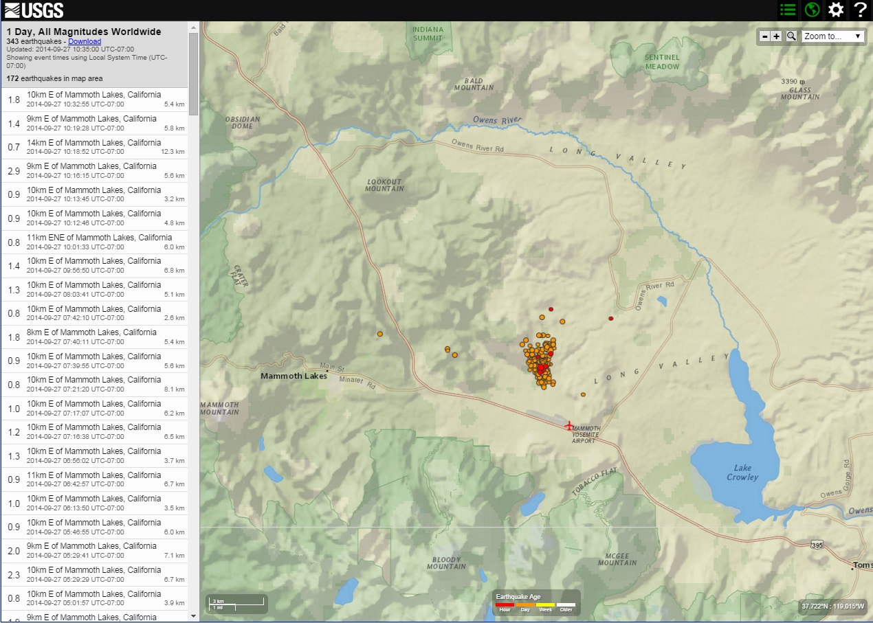
Well theres alot of shaking going on at Mammoth Lakes, California
a reply to: ElectricUniverse
Hi !
I like to watch RSOE EDIS..it also shows the smaller quakes on the map and in a list as you scroll.
Hoping the cluster is just a little tantrum.
Hi !
I like to watch RSOE EDIS..it also shows the smaller quakes on the map and in a list as you scroll.
Hoping the cluster is just a little tantrum.
edit on 25-9-2014 by ujustneverknow because: messed up !
originally posted by: sandman441
here are some pics
www.adn.com...
I honestly cannot think of the last time that damage like this happened.
Looks like standard M6 damage to me.
I have no sympathy for those with the fallen bookshelves, why were they not secured with brackets to the wall?
Same old, same old, at the Supermarket too, exactly same thing happens here every time we get a M6, stuff all over the floor, that is the owners fault jamming as much stock as they can in to one shelf, geez you only have to bump the rack with your trolley and half the self is on the floor. Insurance companies should refuse to pay out for stock loss when there are no attempts to mitigate damage prior, like a little lip along the edge of the shelf. Same with bottle stores, ever hear of crates where every bottle is secured apart from the ones next to it. Naaaaaaaaaaaaaa to simple. So all our premiums keep going up every time there is damage like this, but no one tries to reduce the extent of damage by taking precautions.
No sympathy at all.
edit on 09u26726714 by muzzy because: (no reason given)
a reply to: ElectricUniverse
Yes, that is all quakes, even below 1.0.
It's from USGS, & if you zoom in to 10 miles/20 km,
it says how many quakes in that area & lists them all,
if you have it set for all magnitudes.
Two more in Oregon, both 1.8.
Showing four in Nevada right now.
I'll post a link, but I don't think it will work.
It's an infinite url & I don't remember how to shorten it!!!
earthquake.usgs.gov... scale%22%2C%22autoUpdate%22%3Atrue%2C%22restrictListToMap%22%3Atrue%2C%22timeZone%22%3A%22utc%22%2C%22mapposition%22%3A%5B%5B36.84358155034548%2C-120. 10144036263227%5D%2C%5B38.30416317722255%2C-117.64050286263226%5D%5D%2C%22overlays%22%3A%7B%22plates%22%3Atrue%7D%2C%22viewModes%22%3A%7B%22map%22%3At rue%2C%22list%22%3Atrue%2C%22settings%22%3Atrue%2C%22help%22%3Afalse%7D%7D
WOQ
Yep, it opens up blank!!! Dagnabbit!
edit on 25-9-2014 by wasobservingquietly because: Snap!!!
originally posted by: UtahRosebud
Hello friends!!!!!!! Been away (but lurking a bit) for a while.
Anyway... about the Alaska earthquake. I read on a news site that it was a long lasting quake. However they failed to mention how long it lasted. I'm wondering if anyone knows? Or if any of our Alaska friends who went through it could enlighten us?
And I agree with WOQ... what in the world is going on at Mammoth Lakes?! It is on the outskirts of the Long Valley Caldera.
I felt it last for atleast 45 seconds and some reports of up to a minute. Usually when we get an earthquake we might get a pre shock, then the earth quake rarely do we get an aftershock. This time everything was like it was on top of jello and we rarely get those types of quakes.
Just had a 4.9 in the Cook Inlet region that I felt and apparently shook Kenai pretty decent. There is another one too centered in Kenai but not sure
how big it was.
Edit 5.1
www.facebook.com...
Edit 5.1
www.facebook.com...
edit on 27-9-2014 by
sandman441 because: (no reason given)
a reply to: dreamfox1
I was checking that out a little earlier.
After I went and looked around a little to educate myself and came across this video from 2011 about the long valley super volcano. There was a lot of useful information about the history and one of the things she states is that the area has an eruption around every 500 to 700 years and that we are 600 years since the last eruption.
Keeping an eye on that one.
a reply to: dreamfox1
One possibly has to question why that swarm is pretty much located right under the rather large building with a huge number of fans, obviously there to cool the volcano down??
And New Geothermal Project Approved for Mammoth Lakes
Pokey hole in Momma's skin she not like it too much! Maybe if it does erupt every 500-700 years we are just giving it a bit of lubrication.
M4.6
140km S of Masset, Canada
2014-09-27 21:05:40 UTC
Nearby Cities
140km (87mi) S of Masset, Canada
216km (134mi) SW of Prince Rupert, Canada
312km (194mi) SW of Terrace, Canada
577km (359mi) NW of Campbell River, Canada
631km (392mi) SSE of Juneau, Alaska
earthquake.usgs.gov...
My warning bells have been going off for southeast Alaska for about a week,
and then the 4's start popping up to the south.
I'm expecting a 6+ sometime semi-soon.
originally posted by: PuterMan
a reply to: Olivine
I believe that would be the mid Atlantic ridge! (If my memory is right without looking at the map).
Thank you PM!
You can't imagine the two-handed facepalm I gave myself.
a reply to: PuterMan
This swarm in Long Valley is certainly near the geothermal plants, but from what I read here, the production wells are mostly less than 200 meters deep, and the injection wells (to return spent fluid to the aquifer) are around 750 meters deep. These production areas are west of the "south moat" area and are thought to be geologically seperated by an impermeable landslide block. (though, how can anyone know for certain?).
When this swarm began, I too thought about the geothermal plant, but most of the earthquakes have been 5-8 km deep. Much shallower than the wells.
Anyway, I worked my Paint magic on a satellite map of the area, to show the distance to the swarm.
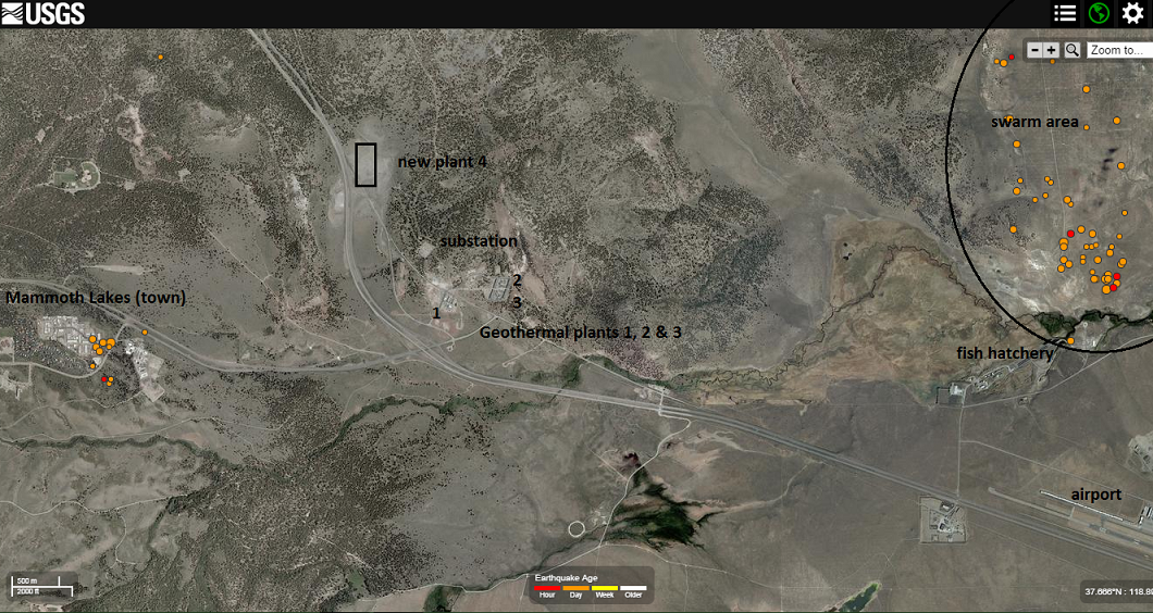
This BLM link is to a 6 page PDF with good maps of the new geothermal plant and well locations.
Most of the wells are in town.
edit on 9/28/2014 by Olivine because: (no reason given)
edit on 9/28/2014 by Olivine because: make image clickable
M4.4
41km SSW of South Dos Palos, California
2014-09-28
20:45:13 UTC
Nearby Cities
41km (25mi) SSW of South Dos Palos, California
42km (26mi) WSW of Mendota, California
48km (30mi) S of Los Banos, California
49km (30mi) ENE of Soledad, California
224km (139mi) SSE of Sacramento, California
earthquake.usgs.gov...
Hold on Cali!
Hope that is not a fore-shock to something bigger!
edit on 28-9-2014 by Darkblade71 because: (no reason given)
a reply to: Olivine
Maybe the quakes are not connected to the extraction, but none the less I do not think that poking holes in the earth and pumping things down them without really knowing what will happen is the most sensible idea that has been implemented.
Let us not forget that once the water has been pumped down, under pressure, we don't actually have any control over where it goes. Gas can percolate through rock, and I am darn sure water can as well.
In order to make a viable hydrothermal electric plant the water must be converted to steam, i.e. raised in temperature by absorbing large amounts of energy. This energy does not just happen, it has to be drained from somewhere and when drained has to be replaced by the area drawing more energy from elsewhere. How do we actually know what the effects of all this energy transference are? Just because the extraction takes place at 750m does not mean the effects will be at 750m as has been amply proven by high pressure injection wells.
One can extract heat from pretty much anywhere on the planet by drilling deep enough. It is the economics of this that mean we poke holes in dangerous areas. Waaaaay to expensive to be safe.
are thought to be geologically seperated by an impermeable landslide block. (though, how can anyone know for certain?).
Maybe the quakes are not connected to the extraction, but none the less I do not think that poking holes in the earth and pumping things down them without really knowing what will happen is the most sensible idea that has been implemented.
Let us not forget that once the water has been pumped down, under pressure, we don't actually have any control over where it goes. Gas can percolate through rock, and I am darn sure water can as well.
In order to make a viable hydrothermal electric plant the water must be converted to steam, i.e. raised in temperature by absorbing large amounts of energy. This energy does not just happen, it has to be drained from somewhere and when drained has to be replaced by the area drawing more energy from elsewhere. How do we actually know what the effects of all this energy transference are? Just because the extraction takes place at 750m does not mean the effects will be at 750m as has been amply proven by high pressure injection wells.
One can extract heat from pretty much anywhere on the planet by drilling deep enough. It is the economics of this that mean we poke holes in dangerous areas. Waaaaay to expensive to be safe.
Even them small one are deadly...
Source
Also Iceland still rockin.
USGS
4.9-Magnitude Earthquake in Peru Kills at Least 8, Damages 300 Homes
At least eight people are dead, five injured and 300 homes damaged after a shallow 4.9-magnitude earthquake rocked a remote village in Peru on Sunday, according to Diario Correo. Most of the victims were killed after their crudely constructed homes collapsed, the Associated Press reports.
Peru's President Ollanta Humala declared a state of emergency for 90 days and stated it would be extended if needed.
(MORE: Volcanic Eruption Kills at Least 30)
The quake was centered 25 miles southeast of Cuzco in the farming town of Misca in the Paruro region and was a relatively shallow five miles deep.
Spanish-Language news site El Comercio reports that four of the dead are children, including a three-month-old baby. Landslides in the area have made it difficult for rescue personnel to reach those affected.
El Comercio reports that nearly 45% of the homes in the village have been destroyed and power has been knocked out. Displaced residents were moved to a local soccer field for safety, according to RPP Noticias.
Source
Also Iceland still rockin.
M5.3 - 101km WNW of Hofn, Iceland
2014-09-29 13:43:02 UTC
Event Time
2014-09-29 13:43:02 UTC
2014-09-29 13:43:02 UTC+00:00 at epicenter
2014-09-29 08:43:02 UTC-05:00 system time
Location
64.562°N 17.195°W depth=10.0km (6.2mi)
USGS
edit on 29-9-2014 by lurksoften because: (no reason
given)
a reply to: lurksoften
Ok i know this area gets alot of earthquakes but second one over 4 i have seen in this are in a day. First one was felt by many people. Just keeping an eye out as always.
USGS
USGS
Ok i know this area gets alot of earthquakes but second one over 4 i have seen in this are in a day. First one was felt by many people. Just keeping an eye out as always.
M4.1 - 24km WSW of Perry, Oklahoma
2014-09-30 03:01:26 UTC
Event Time
2014-09-30 03:01:26 UTC
2014-09-29 22:01:26 UTC-05:00 at epicenter
2014-09-29 22:01:26 UTC-05:00 system time
Location
36.232°N 97.556°W depth=5.0km (3.1mi)
Nearby Cities
24km (15mi) WSW of Perry, Oklahoma
34km (21mi) ESE of Enid, Oklahoma
40km (25mi) NNW of Guthrie, Oklahoma
46km (29mi) WNW of Stillwater, Oklahoma
84km (52mi) N of Oklahoma City, Oklahoma
USGS
M4.1 - 7km SE of Harper, Kansas
2014-09-30 14:55:04 UTC
Event Time
2014-09-30 14:55:04 UTC
2014-09-30 09:55:04 UTC-05:00 at epicenter
2014-09-30 09:55:04 UTC-05:00 system time
Location
37.239°N 97.967°W depth=5.6km (3.5mi)
Nearby Cities
7km (4mi) SE of Harper, Kansas
65km (40mi) WSW of Haysville, Kansas
70km (43mi) WSW of Derby, Kansas
75km (47mi) SW of Wichita, Kansas
200km (124mi) NNW of Oklahoma City, Oklahoma
USGS
The last few weeks of geophysical reports have been somewhat lacking and last weeks was an unmitigated disaster of mislabeling!
I think I have got it sorted this week, and this weeks report includes the celestial full report from the start of the month. Click the images for larger versions. Note on the stats table the Mag 7 "overdue" is getting towards some of it's max gap values. There has to one VERY soon.
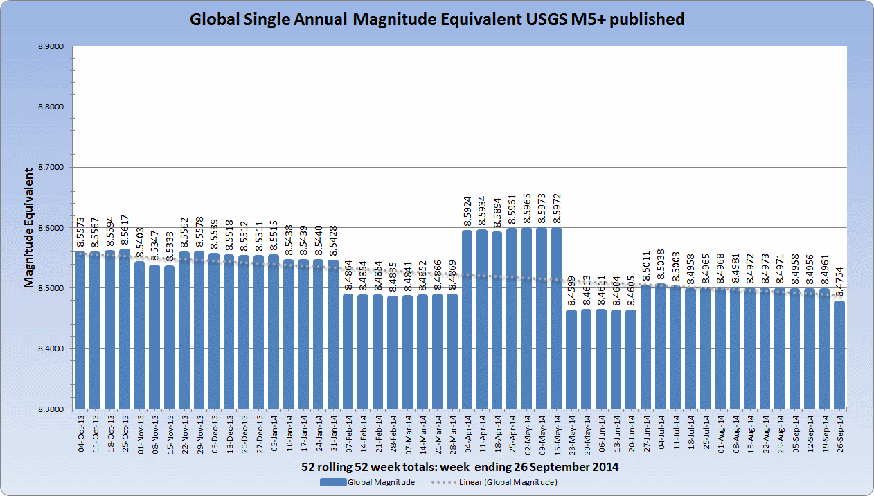
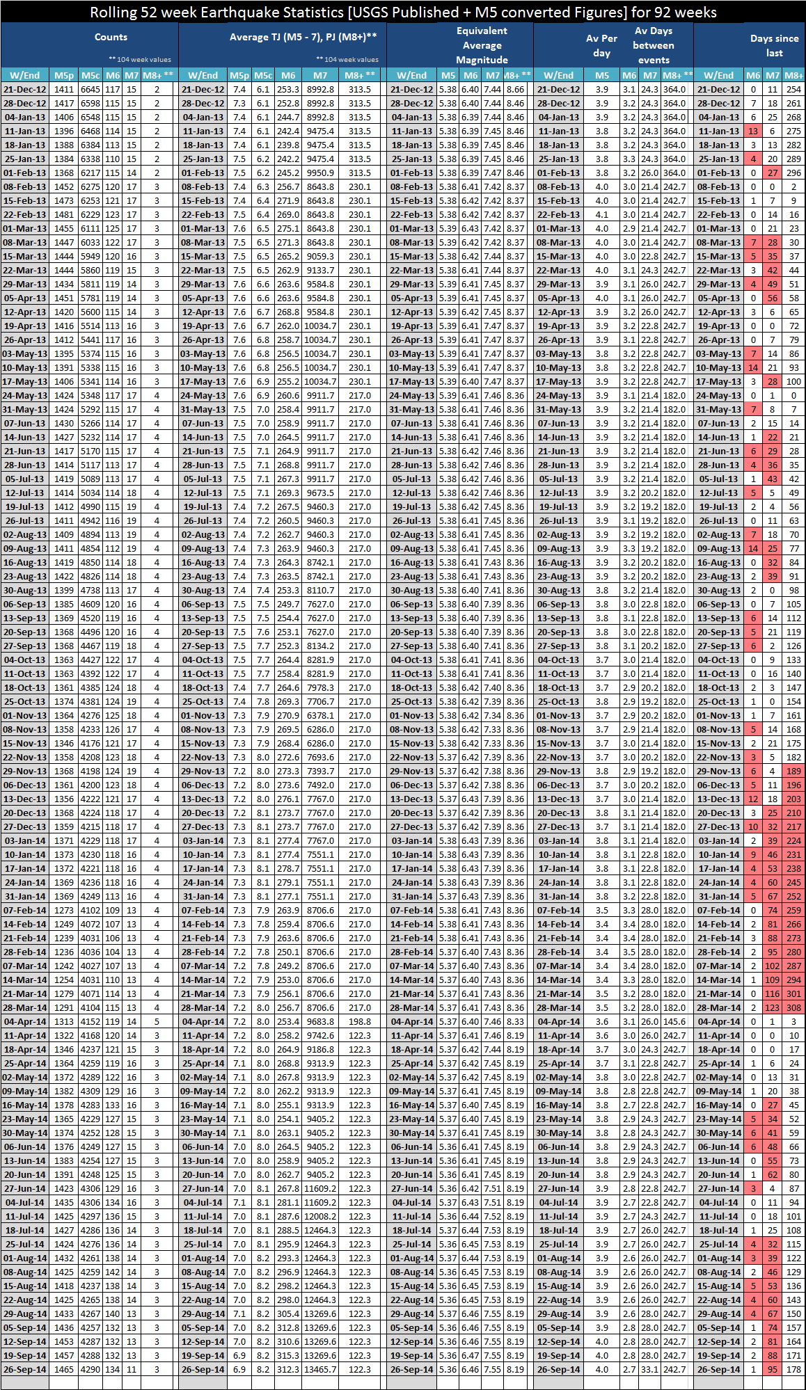
I think I have got it sorted this week, and this weeks report includes the celestial full report from the start of the month. Click the images for larger versions. Note on the stats table the Mag 7 "overdue" is getting towards some of it's max gap values. There has to one VERY soon.


new topics
-
Maestro Benedetto
Literature: 12 minutes ago -
Is AI Better Than the Hollywood Elite?
Movies: 21 minutes ago -
Las Vegas UFO Spotting Teen Traumatized by Demon Creature in Backyard
Aliens and UFOs: 3 hours ago -
2024 Pigeon Forge Rod Run - On the Strip (Video made for you)
Automotive Discussion: 4 hours ago -
Gaza Terrorists Attack US Humanitarian Pier During Construction
Middle East Issues: 5 hours ago -
The functionality of boldening and italics is clunky and no post char limit warning?
ATS Freshman's Forum: 6 hours ago -
Meadows, Giuliani Among 11 Indicted in Arizona in Latest 2020 Election Subversion Case
Mainstream News: 6 hours ago -
Massachusetts Drag Queen Leads Young Kids in Free Palestine Chant
Social Issues and Civil Unrest: 7 hours ago -
Weinstein's conviction overturned
Mainstream News: 8 hours ago -
Supreme Court Oral Arguments 4.25.2024 - Are PRESIDENTS IMMUNE From Later Being Prosecuted.
Above Politics: 9 hours ago
top topics
-
Krystalnacht on today's most elite Universities?
Social Issues and Civil Unrest: 9 hours ago, 9 flags -
Supreme Court Oral Arguments 4.25.2024 - Are PRESIDENTS IMMUNE From Later Being Prosecuted.
Above Politics: 9 hours ago, 8 flags -
Weinstein's conviction overturned
Mainstream News: 8 hours ago, 7 flags -
Gaza Terrorists Attack US Humanitarian Pier During Construction
Middle East Issues: 5 hours ago, 7 flags -
University of Texas Instantly Shuts Down Anti Israel Protests
Education and Media: 12 hours ago, 6 flags -
Massachusetts Drag Queen Leads Young Kids in Free Palestine Chant
Social Issues and Civil Unrest: 7 hours ago, 6 flags -
Meadows, Giuliani Among 11 Indicted in Arizona in Latest 2020 Election Subversion Case
Mainstream News: 6 hours ago, 5 flags -
Las Vegas UFO Spotting Teen Traumatized by Demon Creature in Backyard
Aliens and UFOs: 3 hours ago, 3 flags -
2024 Pigeon Forge Rod Run - On the Strip (Video made for you)
Automotive Discussion: 4 hours ago, 2 flags -
Any one suspicious of fever promotions events, major investor Goldman Sachs card only.
The Gray Area: 14 hours ago, 2 flags
active topics
-
University of Texas Instantly Shuts Down Anti Israel Protests
Education and Media • 213 • : KrustyKrab -
Gaza Terrorists Attack US Humanitarian Pier During Construction
Middle East Issues • 23 • : DBCowboy -
Mood Music Part VI
Music • 3102 • : Hellmutt -
Las Vegas UFO Spotting Teen Traumatized by Demon Creature in Backyard
Aliens and UFOs • 9 • : Ophiuchus1 -
Is AI Better Than the Hollywood Elite?
Movies • 1 • : 5thHead -
British TV Presenter Refuses To Use Guest's Preferred Pronouns
Education and Media • 164 • : Annee -
VP's Secret Service agent brawls with other agents at Andrews
Mainstream News • 56 • : CarlLaFong -
Maestro Benedetto
Literature • 0 • : BrotherKinsMan -
Massachusetts Drag Queen Leads Young Kids in Free Palestine Chant
Social Issues and Civil Unrest • 11 • : marg6043 -
Electrical tricks for saving money
Education and Media • 7 • : chr0naut