It looks like you're using an Ad Blocker.
Please white-list or disable AboveTopSecret.com in your ad-blocking tool.
Thank you.
Some features of ATS will be disabled while you continue to use an ad-blocker.

Quake Watch 2014
page: 88share:
a reply to: Lil Drummerboy
so in your opinion is all that Energy , kinetic, or ,,potential,,
potential being some outside tanfer of Enegry,, which then starts the conversion too Kinetic.
keeping in mind the age old trueism,, if it does not have too move, its not, going too.
ie: crustal upward displacement,,of such a large area.
just curiuos,,
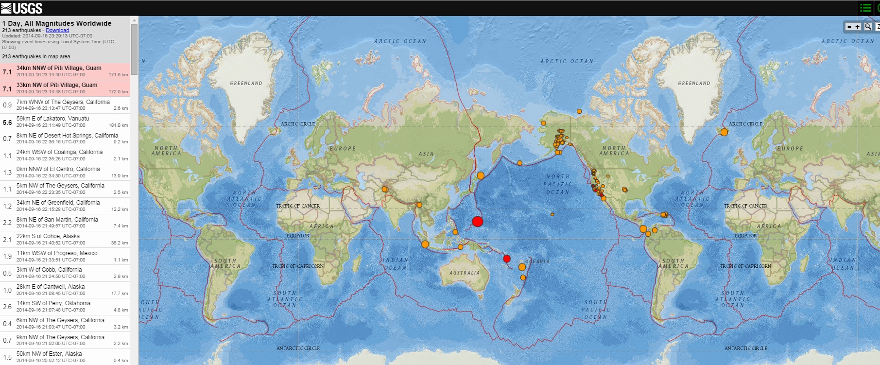
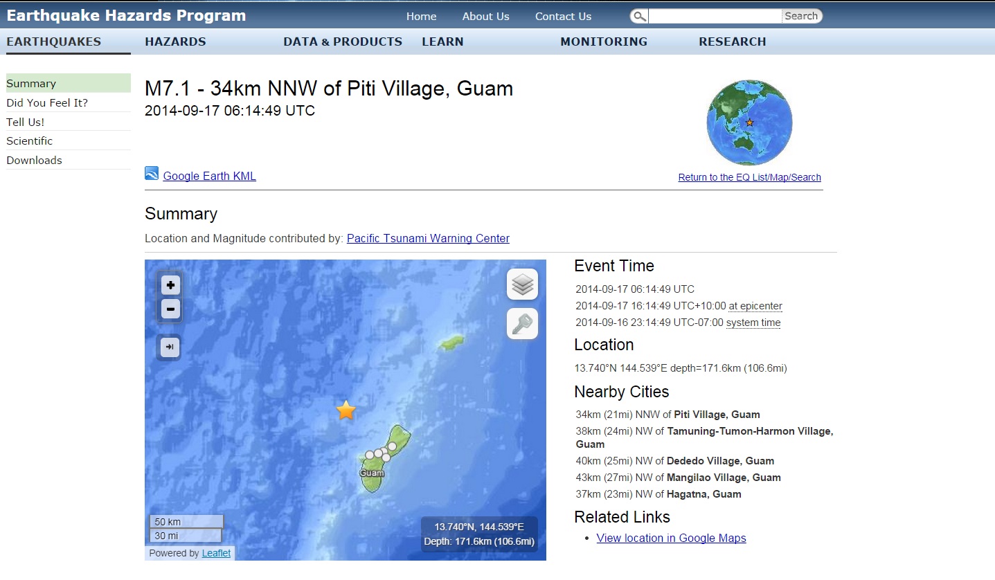
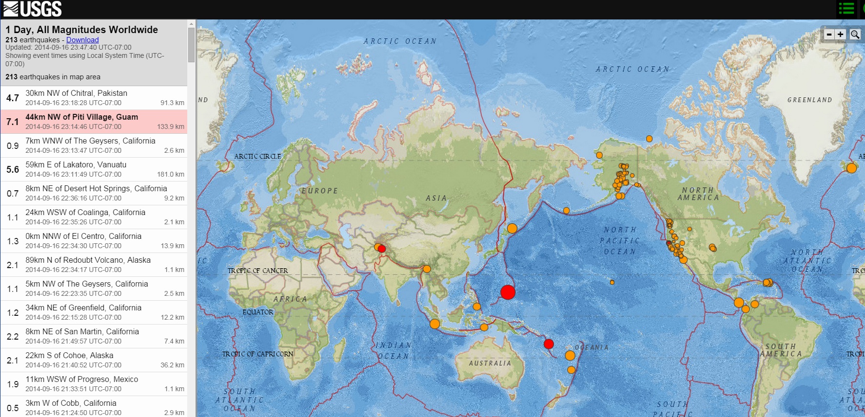
7.1 off the west coast of Guam
Event Time
2014-09-17 06:14:48 UTC
2014-09-17 16:14:48 UTC+10:00 at epicenter
2014-09-16 23:14:48 UTC-07:00 system time
Location
13.700°N 144.500°E depth=172.0km (106.9mi)
Nearby Cities
33km (21mi) NW of Piti Village, Guam
38km (24mi) NW of Tamuning-Tumon-Harmon Village, Guam
41km (25mi) WNW of Dededo Village, Guam
42km (26mi) NW of Mangilao Village, Guam
36km (22mi) NW of Hagatna, Guam
earthquake.usgs.gov...
edit on 17-9-2014 by BunnyMars because: Meh.
edit on 17-9-2014 by BunnyMars because: Meh.^2
a reply to: BunnyMars
DUO 7.1s (For a bit )
files.abovetopsecret.com...
files.abovetopsecret.com...
files.abovetopsecret.com...
earthquake.usgs.gov...

files.abovetopsecret.com...
files.abovetopsecret.com...
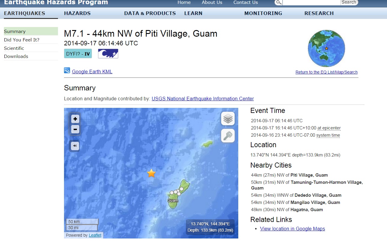
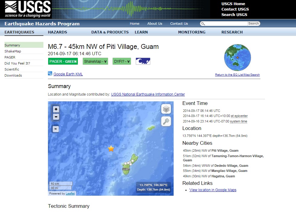
[M6.7 - 45km NW of Piti Village, Guam
2014-09-17 06:14:46 UTC
PAGER - GREENShakeMap - VDYFI? - VTsunami Warning Center
Earthquake location 13.756°N, 144.397°E
Return to the EQ List/Map/Search
kml iconGoogle Earth KML
SummaryLocation and Magnitude contributed by: USGS National Earthquake Information CenterGeneral
+
-
50 km
30 mi
Powered by Leaflet
13.756°N, 144.397°E
Depth: 136.7km (84.9mi)
Event Time
2014-09-17 06:14:46 UTC
2014-09-17 16:14:46 UTC+10:00 at epicenter
2014-09-16 23:14:46 UTC-07:00 system time
Location
13.756°N 144.397°E depth=136.7km (84.9mi)
Nearby Cities
45km (28mi) NW of Piti Village, Guam
51km (32mi) NW of Tamuning-Tumon-Harmon Village, Guam
54km (34mi) WNW of Dededo Village, Guam
55km (34mi) NW of Mangilao Village, Guam
49km (30mi) NW of Hagatna, Guam
files.abovetopsecret.com...
DUO 7.1s (For a bit )
files.abovetopsecret.com...
files.abovetopsecret.com...
files.abovetopsecret.com...
earthquake.usgs.gov...
files.abovetopsecret.com...
files.abovetopsecret.com...
[M6.7 - 45km NW of Piti Village, Guam
2014-09-17 06:14:46 UTC
PAGER - GREENShakeMap - VDYFI? - VTsunami Warning Center
Earthquake location 13.756°N, 144.397°E
Return to the EQ List/Map/Search
kml iconGoogle Earth KML
SummaryLocation and Magnitude contributed by: USGS National Earthquake Information CenterGeneral
+
-
50 km
30 mi
Powered by Leaflet
13.756°N, 144.397°E
Depth: 136.7km (84.9mi)
Event Time
2014-09-17 06:14:46 UTC
2014-09-17 16:14:46 UTC+10:00 at epicenter
2014-09-16 23:14:46 UTC-07:00 system time
Location
13.756°N 144.397°E depth=136.7km (84.9mi)
Nearby Cities
45km (28mi) NW of Piti Village, Guam
51km (32mi) NW of Tamuning-Tumon-Harmon Village, Guam
54km (34mi) WNW of Dededo Village, Guam
55km (34mi) NW of Mangilao Village, Guam
49km (30mi) NW of Hagatna, Guam
files.abovetopsecret.com...
edit on 7/30/2012 by dreamfox1 because: updates.......
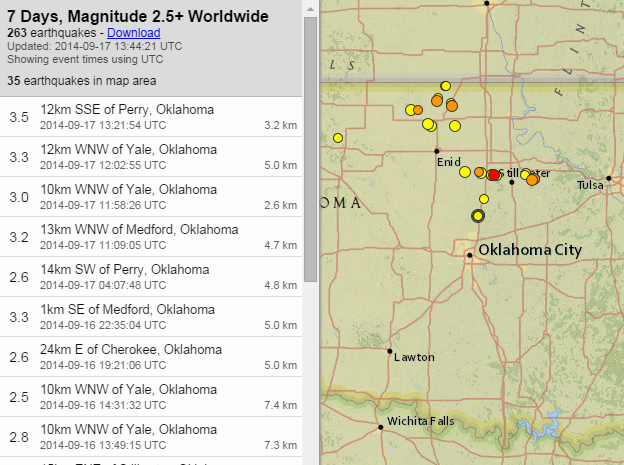
Oklahoma seems to be experiencing another uptick in activity. Image from
USGS showing mag 2.5 and higher over the past 7 days.
I wonder how long this will go on? Injection of fluids may have started this, but it almost seems like something else, tectonic in nature, has been activated. I've no evidence for this thought, just musing.
I wonder how long this will go on? Injection of fluids may have started this, but it almost seems like something else, tectonic in nature, has been activated. I've no evidence for this thought, just musing.
Anybody know where to find a long-term catalog of Icelandic earthquakes, that use IMO or Icelandic Institute of Earth Sciences data? All I can find
is the catalog that ends in 1990.
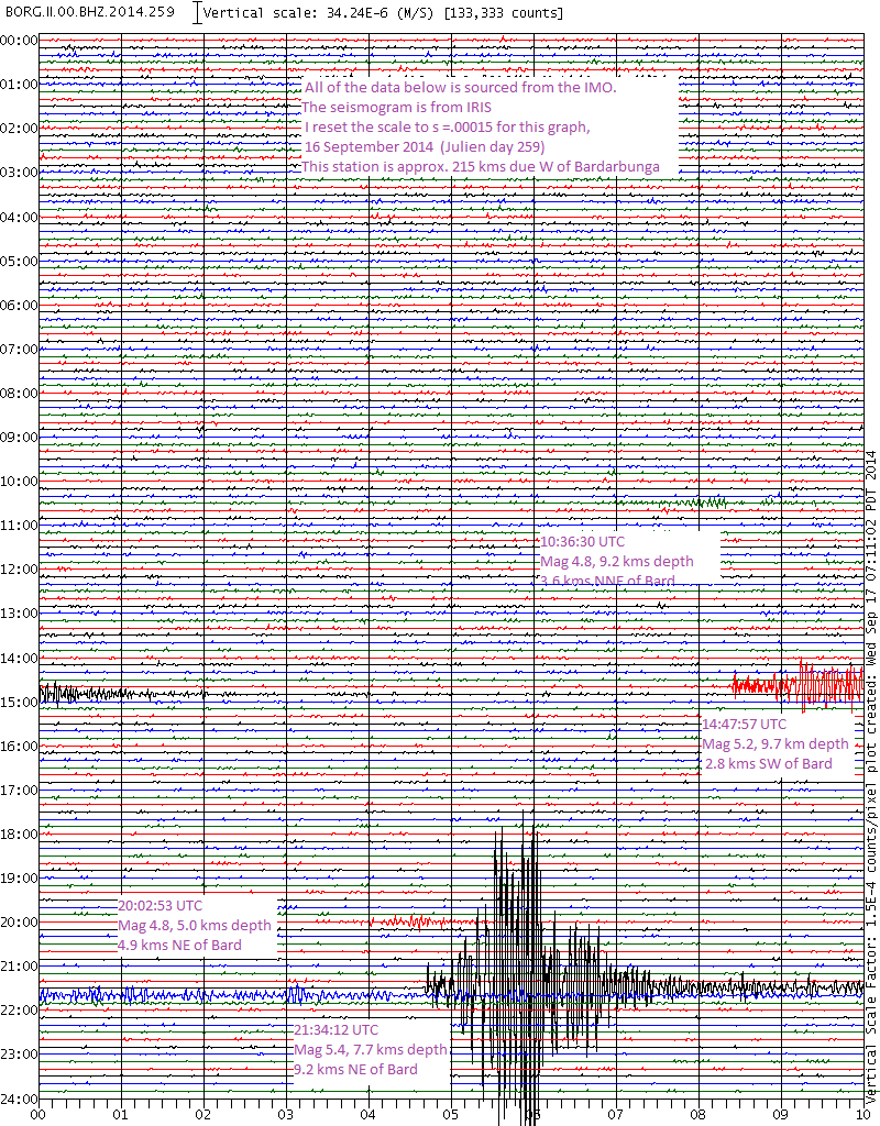
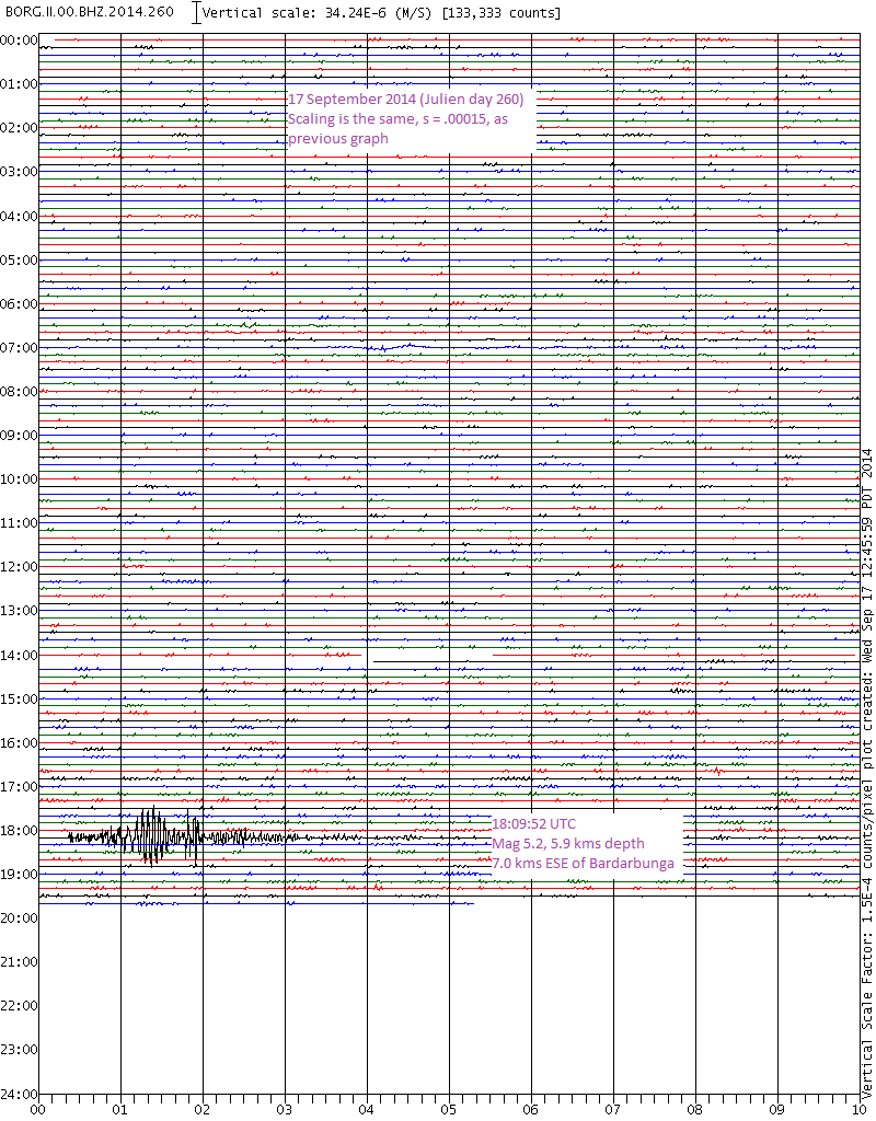
I've about given up trying to understand the IMO's methodology for assigning magnitudes. They are all over the place.
Take the most recent Mag 5.2 found here, for instance.
This is how it looked on the BORG station in GEE. (I monitor this station because it is the nearest publicaly available.)
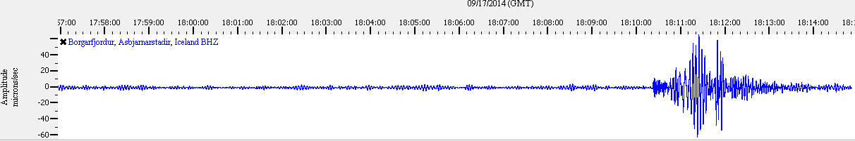
I've been watching these on and off for the past few weeks, so when I saw this one, I thought Mag 4.2-4.4. It definitely wasn't a Mag 5+.
The other reporting agencies saw it this way, too:
EMSC Mag 4.2 mb
GFZ Potsdam Mag 4.2
CEA France Mag 4.3 mb
Then IMO posts Mag 5.2. Huh?
I get it, they know the local geology better than anyone.
There must be something causing attenuation of the waves between Barðarbunga and 215kms west to the BORG seismometer.
So I looked at a couple different days of the BORG station in IRIS, all set to the same scale. (click images for full-sized versions)
Yesterday's plot:
Borg station yesterday--scaled
Today's plot:
 II.BORG.10.BHZ
This shows a mag 5.4 from 7 September 2014. compare it to yesterdays' 5.4: IRIS day 250, station BORG
The magnitudes awarded, don't seem to match amplitudes from day to day, when using the same scale.
Unless, the less than 10 km distance between hypocenters makes that big of a difference? All of the depths are within 4 kms of each other.
I'm just wondering if the details posted on their 48 hr list are later reviewed/revised and published in a catalog somewhere, possibly with magnitude type and focal mechanisms.
I've about given up trying to understand the IMO's methodology for assigning magnitudes. They are all over the place.
Take the most recent Mag 5.2 found here, for instance.
This is how it looked on the BORG station in GEE. (I monitor this station because it is the nearest publicaly available.)
I've been watching these on and off for the past few weeks, so when I saw this one, I thought Mag 4.2-4.4. It definitely wasn't a Mag 5+.
The other reporting agencies saw it this way, too:
EMSC Mag 4.2 mb
GFZ Potsdam Mag 4.2
CEA France Mag 4.3 mb
Then IMO posts Mag 5.2. Huh?
I get it, they know the local geology better than anyone.
There must be something causing attenuation of the waves between Barðarbunga and 215kms west to the BORG seismometer.
So I looked at a couple different days of the BORG station in IRIS, all set to the same scale. (click images for full-sized versions)
Yesterday's plot:
Borg station yesterday--scaled
Today's plot:
 II.BORG.10.BHZ
 This shows a mag 5.4 from 7 September 2014. compare it to yesterdays' 5.4: IRIS day 250, station BORG
The magnitudes awarded, don't seem to match amplitudes from day to day, when using the same scale.
Unless, the less than 10 km distance between hypocenters makes that big of a difference? All of the depths are within 4 kms of each other.
I'm just wondering if the details posted on their 48 hr list are later reviewed/revised and published in a catalog somewhere, possibly with magnitude type and focal mechanisms.
edit on 9/17/2014 by Olivine because: add another example/ ask question
a reply to: Olivine
hraun.vedur.is...
once you get to the year/week/map you want click on [Skjálftalisti] that will give you the list
vika means week, they seem to do the data fortnightly
looks like this
Nr Dags. Timi Breidd Lengd Dypi M ML
1 20080225 011857.993 65.04793 -16.07531 13.161 0.37 0.41
which is
Number Day Time Latitude Longitude Depth M (Mw?) ML
read date/time like this
20080225 011857.993
2008/02/25 01:18:57.993
25th Feb 2008 1:18:57 a.m.
M readings tend to be bigger than ML, thats the column you will find the M5's
I got confused about that using ML for 3 years and missing all the M5's that the likes of GFZ and EMSC were showing, it came to light during the Bardarbunga-Holuhraun series the last 31 days.
edit:
that 5.2 (if it is the same one) lists as
Number Day Time Latitude Longitude Depth M (Mw?) ML
349, 2014/09/17, 18:09:52.856, 64.61878, -17.38981, 5.883km, 5.15M, 3.45ML
3.45ML conversion by EMSC is ???
hraun.vedur.is...
once you get to the year/week/map you want click on [Skjálftalisti] that will give you the list
vika means week, they seem to do the data fortnightly
looks like this
Nr Dags. Timi Breidd Lengd Dypi M ML
1 20080225 011857.993 65.04793 -16.07531 13.161 0.37 0.41
which is
Number Day Time Latitude Longitude Depth M (Mw?) ML
read date/time like this
20080225 011857.993
2008/02/25 01:18:57.993
25th Feb 2008 1:18:57 a.m.
M readings tend to be bigger than ML, thats the column you will find the M5's
I got confused about that using ML for 3 years and missing all the M5's that the likes of GFZ and EMSC were showing, it came to light during the Bardarbunga-Holuhraun series the last 31 days.
edit on 09u26026014 by muzzy because: (no reason given)
edit:
that 5.2 (if it is the same one) lists as
Number Day Time Latitude Longitude Depth M (Mw?) ML
349, 2014/09/17, 18:09:52.856, 64.61878, -17.38981, 5.883km, 5.15M, 3.45ML
3.45ML conversion by EMSC is ???
edit on 0900000026026014 by muzzy because: (no reason given)
bit of a disturbance the last few days down south Solander Is. region 4 x 4.5-4.9's
goo.gl...
has been really quiet here in NZ for the last month, nothing much of any decent size, been concentrating on Bardarbunga over on Volcano Watch 2014
goo.gl...
has been really quiet here in NZ for the last month, nothing much of any decent size, been concentrating on Bardarbunga over on Volcano Watch 2014
a reply to: Olivine
no problem
takes a bit of navigating, too bad they didn't have a complete list of the whole lot in one file.There must be 20 years worth of data there, that would be approx. over half a million earthquakes based on an average ( 2014) of 2350 a month!!!!
no problem
takes a bit of navigating, too bad they didn't have a complete list of the whole lot in one file.There must be 20 years worth of data there, that would be approx. over half a million earthquakes based on an average ( 2014) of 2350 a month!!!!
couple of 4's not too far from us early this morning, fairly deep, didn't feel them
Date/Time NZST: 19/09/2014 23:29:14
Date/Time UTC: 19/09/2014 11:29:14
Latitude, Longitude: -40.4263, 174.6796
Magnitude: 4.23M
Depth: 104.14 km
Energy Released: 32.97298949 tonnes of TNT
and a second later
Date/Time NZST: 19/09/2014 23:29:15
Date/Time UTC: 19/09/2014 11:29:15
Latitude, Longitude: -40.3872, 174.6821
Magnitude: 4.43M
Depth: 87.20 km
Energy Released: 66.93577932 tonnes of TNT
Location: Wanganui Basin
goo.gl...
a reply to: Olivine
In my experience BORG is always under par. It is very bad at picking up teleseisms as well.
I believe that would be the mid Atlantic ridge! (If my memory is right without looking at the map).
And in addition to what Muzzy told you, you may also not be aware that the Pro version of QVSData can download those direct from the catalogue (if that bit is still working - I have not done it for a while)
In my experience BORG is always under par. It is very bad at picking up teleseisms as well.
There must be something causing attenuation of the waves between Barðarbunga and 215kms west to the BORG seismometer.
I believe that would be the mid Atlantic ridge! (If my memory is right without looking at the map).
I'm just wondering if the details posted on their 48 hr list are later reviewed/revised and published in a catalog somewhere
And in addition to what Muzzy told you, you may also not be aware that the Pro version of QVSData can download those direct from the catalogue (if that bit is still working - I have not done it for a while)
Couple of rattlers north of Patras, Greece 4.7 and 4.0 plus a few smaller aftershocks,
bbnet.gein.noa.gr...
I was reading EMSC felt reports, a few of the locals getting upset,
one guy ( I presume its a guy) in Aigio 39 km E from epicenter getting real pissed off about it
comments on the M4.7
comments on the M4.0
bbnet.gein.noa.gr...
I was reading EMSC felt reports, a few of the locals getting upset,
one guy ( I presume its a guy) in Aigio 39 km E from epicenter getting real pissed off about it
comments on the M4.7
comments on the M4.0
edit on 09u26226214 by muzzy because: (no reason given)
a reply to: PuterMan
yes it is still working I just ran part of 1995 off it
lucky I read this, I forgot all about that option, I was wondering where I got so many 2013 text files for Iceland, that is where!
It looks jumbled when you download it but if you copy and paste it into Excel its makes sense, in rows.
I should have given you credit for pointing me to the Iceland catalog as well, was a few years ago now I believe
yes it is still working I just ran part of 1995 off it
lucky I read this, I forgot all about that option, I was wondering where I got so many 2013 text files for Iceland, that is where!
It looks jumbled when you download it but if you copy and paste it into Excel its makes sense, in rows.
edit on 09u26226214 by muzzy because:
(no reason given)
I should have given you credit for pointing me to the Iceland catalog as well, was a few years ago now I believe
edit on 09u26226214 by
muzzy because: (no reason given)
a reply to: muzzy
's OK. I wasn't looking for recognition.
He should complain to his MEP. I am sure the EU has regulated earthquakes. They seem to regulate everything else.
European Union. Regulation of potatoes: Potatoes sold in shops shall be of even shape and between 40mm and 80mm in diameter.
European Union. Regulation of Earthquakes: Earthquakes occurring in the EU economic zone shall be at a consistent depth of 10km and between Magnitude 1.0 and 4.0 on the Richter scale. Severe penalties including but not limited to fines and imprisonment shall be applicable where authorities have permitted earthquakes outside this range or have failed to notify a region that such an earthquake is scheduled to occur. (L'Aquila geologists please note)
Anyone noticed that the Mag 7 Marianas is now a Mag 6.7?
I should have given you credit for pointing me to the Iceland catalog as well
's OK. I wasn't looking for recognition.
one guy ( I presume its a guy) in Aigio 39 km E from epicenter getting real pissed off about it
He should complain to his MEP. I am sure the EU has regulated earthquakes. They seem to regulate everything else.
European Union. Regulation of potatoes: Potatoes sold in shops shall be of even shape and between 40mm and 80mm in diameter.
European Union. Regulation of Earthquakes: Earthquakes occurring in the EU economic zone shall be at a consistent depth of 10km and between Magnitude 1.0 and 4.0 on the Richter scale. Severe penalties including but not limited to fines and imprisonment shall be applicable where authorities have permitted earthquakes outside this range or have failed to notify a region that such an earthquake is scheduled to occur. (L'Aquila geologists please note)
Anyone noticed that the Mag 7 Marianas is now a Mag 6.7?
Public ID 2014p715167
Intensity strong
Universal Time September 22 2014, 14:41:23
NZ Standard Time Tue, Sep 23 2014, 2:41:23 am
Depth 24 km
Magnitude 5.5
Location 15 km west of Pongaroa (East coast North Island)
Latitude, Longitude -40.60, 175.99
www.geonet.org.nz...
This woke me up!
Cat was on the bed and jumped down and out the cat door like a flash then the shaking started, first time he has reacted to one. His twin brother never moved, may have lifted his head, don't know it was dark.
He was a bit spooked all day yesterday too, we thought it was the weather, been a real wintery storm on, high winds, rain, small hail, very cold for this time of year, was 4C yesterday at one point in the middle of the day.
been quite a while since the last one (on land), last one was 06/06/2014 03:46:54 SW of Mt Ruapehu 103.1 km deep
edit on 09u26426414 by muzzy
because: (no reason given)
edit:
was this yesterday early morning NZST too, down south of NZ
ID: 2014p712196 Network: geonet
Status: automatic
Date/Time NZST: 22/09/2014 00:17:43
Date/Time UTC: 21/09/2014 12:17:43
Latitude, Longitude: -49.1369, 164.154
Magnitude: 5.40M
Depth: 124.14 km
Energy Released: 1916.9391 tonnes of TNT
Location: Auckland Islands. N.Z. Region
and a couple of high 4's NE of the North Island
ID: 2014p712505 Network: geonet
Status: automatic
Date/Time NZST: 22/09/2014 03:02:20
Date/Time UTC: 21/09/2014 15:02:20
Latitude, Longitude: -35.7891, -179.9846
Magnitude: 4.97M
Depth: 12.00 km
Energy Released: 423.4560 tonnes of TNT
and
ID: 2014p712511 Network: geonet
Status: automatic
Date/Time NZST: 22/09/2014 03:05:29
Date/Time UTC: 21/09/2014 15:05:29
Latitude, Longitude: -36.0692, 178.9713
Magnitude: 4.93M
Depth: 12.00 km
Energy Released: 368.1784 tonnes of TNT
GFZ had those two as 5's mb
2014-09-21 15:05:27 5.3 35.87°S 178.70°E 18 C Off E. Coast of N. Island, N.Z.
2014-09-21 15:02:30 5.5 35.94°S 178.42°E 17 M MT Off E. Coast of N. Island, N.Z.
geofon.gfz-potsdam.de...
seems NZ has kicked back into life after quite a long period of quiet
edit on 0900000026426414 by muzzy because: (no reason given)
edit2:
those 4 quakes pumped up the total energy released from 2,191.164TTNT to 8,103.119TTNT in the snap of the fingers geologically speaking
still quite low for the month though, Kermadecs have been quiet too.
edit on 09u26426414 by muzzy because: (no reason given)
a reply to: PuterMan
ha ha
Now that Scotland is back in the United Kingdom (was close) they should all 3 get out of the EU, I'm sure life was better before they joined it.
I only seen that Marianas as a 7 on USGS, all the rest had 6ish, so I waited before (not) putting it up on the World 7's
ha ha
Now that Scotland is back in the United Kingdom (was close) they should all 3 get out of the EU, I'm sure life was better before they joined it.
I only seen that Marianas as a 7 on USGS, all the rest had 6ish, so I waited before (not) putting it up on the World 7's
new topics
-
Geddy Lee in Conversation with Alex Lifeson - My Effin’ Life
People: 36 minutes ago -
God lived as a Devil Dog.
Short Stories: 52 minutes ago -
Happy St George's day you bigots!
Breaking Alternative News: 2 hours ago -
TLDR post about ATS and why I love it and hope we all stay together somewhere
General Chit Chat: 3 hours ago -
Hate makes for strange bedfellows
US Political Madness: 5 hours ago -
Who guards the guards
US Political Madness: 8 hours ago -
Has Tesla manipulated data logs to cover up auto pilot crash?
Automotive Discussion: 9 hours ago
top topics
-
Hate makes for strange bedfellows
US Political Madness: 5 hours ago, 14 flags -
whistleblower Captain Bill Uhouse on the Kingman UFO recovery
Aliens and UFOs: 14 hours ago, 11 flags -
Who guards the guards
US Political Madness: 8 hours ago, 10 flags -
1980s Arcade
General Chit Chat: 17 hours ago, 7 flags -
Deadpool and Wolverine
Movies: 17 hours ago, 4 flags -
TLDR post about ATS and why I love it and hope we all stay together somewhere
General Chit Chat: 3 hours ago, 3 flags -
Has Tesla manipulated data logs to cover up auto pilot crash?
Automotive Discussion: 9 hours ago, 2 flags -
Happy St George's day you bigots!
Breaking Alternative News: 2 hours ago, 2 flags -
God lived as a Devil Dog.
Short Stories: 52 minutes ago, 1 flags -
Geddy Lee in Conversation with Alex Lifeson - My Effin’ Life
People: 36 minutes ago, 0 flags
active topics
-
Candidate TRUMP Now Has Crazy Judge JUAN MERCHAN After Him - The Stormy Daniels Hush-Money Case.
Political Conspiracies • 728 • : Justoneman -
New whistleblower Jason Sands speaks on Twitter Spaces last night.
Aliens and UFOs • 43 • : Ophiuchus1 -
British TV Presenter Refuses To Use Guest's Preferred Pronouns
Education and Media • 115 • : FlyersFan -
"We're All Hamas" Heard at Columbia University Protests
Social Issues and Civil Unrest • 244 • : KrustyKrab -
-@TH3WH17ERABB17- -Q- ---TIME TO SHOW THE WORLD--- -Part- --44--
Dissecting Disinformation • 618 • : daskakik -
Happy St George's day you bigots!
Breaking Alternative News • 14 • : SprocketUK -
Republican Voters Against Trump
2024 Elections • 287 • : some_stupid_name -
Hate makes for strange bedfellows
US Political Madness • 31 • : ByeByeAmericanPie -
God lived as a Devil Dog.
Short Stories • 1 • : FlyersFan -
SC Jack Smith is Using Subterfuge Tricks with Donald Trumps Upcoming Documents Trial.
Dissecting Disinformation • 108 • : Threadbarer