It looks like you're using an Ad Blocker.
Please white-list or disable AboveTopSecret.com in your ad-blocking tool.
Thank you.
Some features of ATS will be disabled while you continue to use an ad-blocker.

Quake Watch 2014
page: 86share:
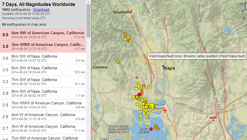
Napa, N. California elapsed time 38:50:57 (hh:mm:ss)
not many aftershocks for a 6.0Mw????
summary
mag1= 43 , mag2= 30 , mag3= 2
mag4= 0 , mag5= 0 , mag6= 1
total= 76, total energy released= 15,088.709 TTNT
left click image for interactive map, right click "view image" for full size
not many aftershocks for a 6.0Mw????
summary
mag1= 43 , mag2= 30 , mag3= 2
mag4= 0 , mag5= 0 , mag6= 1
total= 76, total energy released= 15,088.709 TTNT
left click image for interactive map, right click "view image" for full size
edit on 0800000023723714 by muzzy because: (no reason
given)
a reply to: muzzy
The lack of larger (mag 4 range) aftershocks is worrying, But I see one rolling in on GEE now.
Waiting for USGS...
Nice map work, as usual, Muzzy. Thanks.
Hey Muzzy, would this map work as a base for your Iceland projects? I like it because it lists all of the place names used as reference by the IMO in their quake tables
Mag 3.9 Largest aftershock to date, I believe.
edit on 8/26/2014 by Olivine because: (no reason given)
edit on 8/26/2014 by Olivine because: add a link for Muzzard
a reply to: Olivine
I was wondering about the aftershocks as well.
If you look almost anywhere else on the USGS global map at the aftershocks to the bigger ones,
most have aftershocks that are about a point lower and then smaller and smaller..
I have not seen any big aftershocks.
Could this be because this was centered between two fault lines and not on a known active fault line?
(seems to me someone said it was an ancient fault line, but I could be mistaken)
edit on 26-8-2014 by Darkblade71 because: (no reason given)
a reply to: Darkblade71
Here is a good blog post from Scientific American, that reports on the findings of geology students from UC Davis.
They report that the Brown's Valley section of the West Napa fault was responsible, and that:
So, you're correct in thinking that this was a fault zone, and it very well could be why we haven't seen any moderate sized aftershocks.
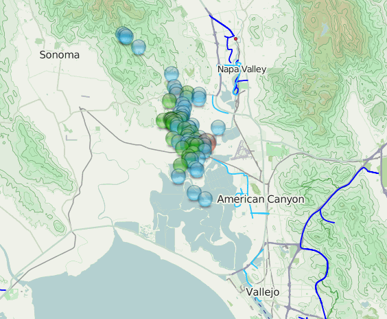
The handful of aftershocks at the northern end of the West Napa fault (just S of Yountville on the image below), may be signalling more movement is possible still further north of the mainshock. This is just my amateur opinion.
(click for larger image)
image source
Here is a good blog post from Scientific American, that reports on the findings of geology students from UC Davis.
They report that the Brown's Valley section of the West Napa fault was responsible, and that:
The rupture zone they found is right about half a kilometer (.3 mi) wide, 16 km (10 mi) long, and had a maximum slip of 25 centimeters (9 inches).
So, you're correct in thinking that this was a fault zone, and it very well could be why we haven't seen any moderate sized aftershocks.
The handful of aftershocks at the northern end of the West Napa fault (just S of Yountville on the image below), may be signalling more movement is possible still further north of the mainshock. This is just my amateur opinion.

(click for larger image)
image source
Just checked and all of the USGS Heliplots are unavailable.
ANSS Backbone Heliplots
GSN Heliplots
Does anyone know why this happens?
ANSS Backbone Heliplots
GSN Heliplots
Does anyone know why this happens?
a reply to: muzzy
Hmm, that's strange that it is prompting you. The map is interactive, so I don't believe there is a .pdf available. Bummer.
a reply to: whatnext21
I'm not sure what is going on, but off and on today, the US network stations and the TA stations have gone kaput in GEE, too. Someone must be doing some meddling behind the scenes
edit on 8/26/2014 by Olivine because: adding a second reply to make good use of forum space, um, not that I forgot before hitting the "post"
button
a reply to: Olivine
this one is pretty good, its designed for I-pad but worksgreat on the laptop, 7 types of map available
atlas.lmi.is...
every country should have the same.
this one is pretty good, its designed for I-pad but worksgreat on the laptop, 7 types of map available
atlas.lmi.is...
every country should have the same.
Downgraded to a 4.8
M5.0 - 44km ESE of Middleton Island, Alaska
2014-08-27 06:10:19 UTC
Location
59.344°N 145.559°W depth=13.0km (8.1mi)
Nearby Cities
44km (27mi) ESE of Middleton Island, Alaska
319km (198mi) SE of Anchorage, Alaska
330km (205mi) SE of Knik-Fairview, Alaska
607km (377mi) W of Whitehorse, Canada
620km (385mi) S of Badger, Alaska
earthquake.usgs.gov...
I don't like that one at all.
The downgrade doesn't make me feel better..lol
edit on 27-8-2014 by Darkblade71 because: (no reason given)
originally posted by: PuterMan
@Olivine: Add Cali 6 and NW Tremor and what do you get?? W8 - love it (see below) (Oh I went widescreen for the first time as well having resisted for years)
Puterman, I've no clue what we will get, but the tremor is still going strong.
The PNSN graphs seem to have a glitch at the moment, the only graphics that show are the density maps. This image shows the past 18 days of activity.

source
A full 36.9 hours with 635 epicenters just for yesterday.
Looking at the spectrograms for today, the deep tremors are still popping away. (link is for northern California, all other ETS regions are linked in the drop-down)
I'm glad to read that you love Win8. This weekend I will be purchasing a new compy--my significant other has graciously let me borrow his for the past few days because he noticed I couldn't keep my eyes off the Napa/Iceland happenings. Sweetheart, that man, for understanding my addiction.
edit on 8/28/2014 by Olivine because: (no reason given)
M3.9 - West of Vancouver Island 2014-08-29
17:31:53 UTC
Location
50.657°N 139.415°W depth=15.1km (9.4mi)
Nearby Cities
622km (386mi) SW of Masset, Canada
739km (459mi) WSW of Prince Rupert, Canada
848km (527mi) WSW of Terrace, Canada
909km (565mi) SSW of Juneau, Alaska
1009km (627mi) W of Campbell River, Canada
earthquake.usgs.gov...
A long ways out, but just in a weird spot.
M5.0 - 197km ENE of Norman Wells, Canada
2014-08-29 18:37:29 UTC
Location
65.644°N 122.656°W depth=2.2km (1.4mi)
Nearby Cities
1. 197km (122mi) ENE of Norman Wells, Canada
2. 538km (334mi) NW of Yellowknife, Canada
3. 828km (514mi) NE of Whitehorse, Canada
4. 1021km (634mi) NNE of Juneau, Alaska
5. 1051km (653mi) N of Fort St. John, Canada
earthquake.usgs.gov...
This seems unusual, not often I see quakes in this part of the world and shallow too... What do our resident quake experts make of this?
muzzys rule
whenever the TTNT for the 24 hour period falls below 10, there is a M5 within 6 days
so hows it stacking up for August 2014?
1st Aug=9TTNT, 4th Aug M5, within 3 days
5th Aug =6TTNT, 6th Aug M5, within1 day
10th Aug =10TTNT, 14th Aug M5, within 4days
15th Aug =7TTNT, nothing
20th Aug =6TTNT, 25th Aug M5, within 5days
28th Aug=7TTNT, 29th Aug M5, within1 day
so 1/6 or 83.3% of the time it works out
show me any other method of prediction with 83% accuracy?
none!
only applies for NZ though
most of the 5's are north of the main islands, in the Kermadec's or between, seems to be the only area of action this period
go with this link as it will update when I renew it
Aug 2014 energy and numbers counts
edit on 08u24224214 by muzzy because: (no reason given)
Mother Earth is so active at the moment... I'm literally on pins when I open USGS and RSOE in the mornings.
Quake in Alaska though not as shallow as the one in Canada yesterday.
M5.1 - 60km NW of Ester, Alaska
2014-08-31 03:06:57 UTC
Location
65.155°N 148.983°W depth=15.5km (9.6mi)
Nearby Cities
60km (37mi) NW of Ester, Alaska
67km (42mi) NW of College, Alaska
72km (45mi) WNW of Fairbanks, Alaska
81km (50mi) WNW of Badger, Alaska
862km (536mi) NW of Whitehorse, Canada
Hmm, small swarm in AK, the biggest being a 5.1, and most recent being a 4.6 in magnitude. Might we hear a bit more from the region, or is this liable
to calm down?
Via USGS
4.6 66km NW of Ester, Alaska 2014-08-31 12:24:57 UTC 16.0 km
3.2 54km NW of Ester, Alaska 2014-08-31 09:33:28 UTC 12.1 km
3.5 56km NW of Ester, Alaska 2014-08-31 08:10:54 UTC 18.9 km
2.6 68km ENE of Manley Hot Springs, Alaska 2014-08-31 07:39:19 UTC 7.8 km
3.0 48km NW of Ester, Alaska 2014-08-31 04:52:49 UTC 13.7 km
2.7 57km NW of Ester, Alaska 2014-08-31 04:01:29 UTC 11.9 km
2.8 56km NW of Ester, Alaska 2014-08-31 03:26:15 UTC 5.9 km
2.6 40km NW of Ester, Alaska 2014-08-31 03:16:16 UTC 26.9 km
2.5 61km NW of Ester, Alaska 2014-08-31 03:15:55 UTC 16.8 km
2.5 61km NW of Ester, Alaska 2014-08-31 03:13:38 UTC 9.4 km
5.1 60km NW of Ester, Alaska 2014-08-31 03:06:57 UTC 15.5 km
Via USGS
Now it's up to 275 quakes of all magnitudes,
in the last 24 hours, in Ester, Alaska!
What's going on up there?
Any volcanoes in the area???
WOQ
in the last 24 hours, in Ester, Alaska!
What's going on up there?
Any volcanoes in the area???
WOQ
edit on 31-8-2014 by wasobservingquietly because: (no reason given)
edit on 31-8-2014 by wasobservingquietly because: (no
reason given)
a reply to: wasobservingquietly
Interesting that this cluster of quakes in Alaska seems just a bit southeast of some of the most previous quake swarms in central AK from a few months ago. It seems like they are creeping across the state out towards the kenai peninsula.
Just some of my own random thoughts based on a path I think I might be seeing.
Currently watching ABC Live Quake Cam and have noticed the needle vibrating more than it usually does wondering
if this has happened before or is it just malfunctioning.
reply to: GoShredAK
Just looked up some info.
Closest volcano is Buzzards Creek, 64.061*N -148.432*W.
Coordinates of Ester's quakes, 65.155*N -148.983*W.
Even more interesting...the latitude of all the activity in Iceland right now:
64.723*N !!!
Hmmm...
WOQ
Just looked up some info.
Closest volcano is Buzzards Creek, 64.061*N -148.432*W.
Coordinates of Ester's quakes, 65.155*N -148.983*W.
Even more interesting...the latitude of all the activity in Iceland right now:
64.723*N !!!
Hmmm...
WOQ
edit on 31-8-2014 by wasobservingquietly because: (no reason given)
new topics
-
Weinstein's conviction overturned
Mainstream News: 22 minutes ago -
Supreme Court Oral Arguments 4.25.2024 - Are PRESIDENTS IMMUNE From Later Being Prosecuted.
Above Politics: 1 hours ago -
Krystalnacht on today's most elite Universities?
Social Issues and Civil Unrest: 2 hours ago -
Chris Christie Wishes Death Upon Trump and Ramaswamy
Politicians & People: 2 hours ago -
University of Texas Instantly Shuts Down Anti Israel Protests
Education and Media: 4 hours ago -
Any one suspicious of fever promotions events, major investor Goldman Sachs card only.
The Gray Area: 6 hours ago -
God's Righteousness is Greater than Our Wrath
Religion, Faith, And Theology: 11 hours ago
top topics
-
VP's Secret Service agent brawls with other agents at Andrews
Mainstream News: 15 hours ago, 11 flags -
Nearly 70% Of Americans Want Talks To End War In Ukraine
Political Issues: 16 hours ago, 6 flags -
Sunak spinning the sickness figures
Other Current Events: 16 hours ago, 5 flags -
Krystalnacht on today's most elite Universities?
Social Issues and Civil Unrest: 2 hours ago, 5 flags -
Supreme Court Oral Arguments 4.25.2024 - Are PRESIDENTS IMMUNE From Later Being Prosecuted.
Above Politics: 1 hours ago, 4 flags -
Weinstein's conviction overturned
Mainstream News: 22 minutes ago, 4 flags -
Electrical tricks for saving money
Education and Media: 14 hours ago, 4 flags -
University of Texas Instantly Shuts Down Anti Israel Protests
Education and Media: 4 hours ago, 2 flags -
Any one suspicious of fever promotions events, major investor Goldman Sachs card only.
The Gray Area: 6 hours ago, 2 flags -
Chris Christie Wishes Death Upon Trump and Ramaswamy
Politicians & People: 2 hours ago, 1 flags
active topics
-
British TV Presenter Refuses To Use Guest's Preferred Pronouns
Education and Media • 157 • : Annee -
University of Texas Instantly Shuts Down Anti Israel Protests
Education and Media • 97 • : marg6043 -
-@TH3WH17ERABB17- -Q- ---TIME TO SHOW THE WORLD--- -Part- --44--
Dissecting Disinformation • 667 • : daskakik -
Supreme Court Oral Arguments 4.25.2024 - Are PRESIDENTS IMMUNE From Later Being Prosecuted.
Above Politics • 11 • : network dude -
Weinstein's conviction overturned
Mainstream News • 7 • : underpass61 -
President BIDEN Vows to Make Americans Pay More Federal Taxes in 2025 - Political Suicide.
2024 Elections • 144 • : underpass61 -
Sunak spinning the sickness figures
Other Current Events • 19 • : Freeborn -
Candidate TRUMP Now Has Crazy Judge JUAN MERCHAN After Him - The Stormy Daniels Hush-Money Case.
Political Conspiracies • 746 • : matafuchs -
Chris Christie Wishes Death Upon Trump and Ramaswamy
Politicians & People • 7 • : underpass61 -
SETI chief says US has no evidence for alien technology. 'And we never have'
Aliens and UFOs • 65 • : andy06shake