It looks like you're using an Ad Blocker.
Please white-list or disable AboveTopSecret.com in your ad-blocking tool.
Thank you.
Some features of ATS will be disabled while you continue to use an ad-blocker.

Quake Watch 2014
page: 82share:
a reply to: Hellas
no problem
this particular event has started a whole new method of mapping for me, using EMSC
I started doing that graph using GFZ off Putermans QVS data program but it only goes back to 06/06/2013 for some reason, so I tried using EMSC search using the word CRETE.
Got what I wanted.
Further to that graph, I have plotted the last 50 quakes, using new (old style google type) numbered icons 1-50
In this case I made the M4 quakes grey, just happened to be the easiest to experiment with, I'll change that later.
It appears that Google Maps now allow more than 30 individual numbrered icons on their interactive maps, works for me anyway, this is a great advancement for research purposes.
So here we are, Crete last 50 quakes above M4, 19/06/2013-08/08/2014, Number 1 is the oldest, 50 is the last 4.8 the other day 08/08/2014
 (click image for interactive version, opens in new tab/window)
is this a foreshock?
Based on the distance from the last M6+, and the time lapse, I would say YES this is a foreshock, another 6+ is bound to come along at some stage, when is the big question, or it could just be background seismicity in the mean time, the last 10 are scattered all over the place.
Let me know if the icons over the number 30 don't show, it may depend on your server or browser whether they show up past 30 or not.
I will do a test and see if they will allow more icons.
no problem
this particular event has started a whole new method of mapping for me, using EMSC
I started doing that graph using GFZ off Putermans QVS data program but it only goes back to 06/06/2013 for some reason, so I tried using EMSC search using the word CRETE.
Got what I wanted.
Further to that graph, I have plotted the last 50 quakes, using new (old style google type) numbered icons 1-50
In this case I made the M4 quakes grey, just happened to be the easiest to experiment with, I'll change that later.
It appears that Google Maps now allow more than 30 individual numbrered icons on their interactive maps, works for me anyway, this is a great advancement for research purposes.
So here we are, Crete last 50 quakes above M4, 19/06/2013-08/08/2014, Number 1 is the oldest, 50 is the last 4.8 the other day 08/08/2014
is this a foreshock?
Based on the distance from the last M6+, and the time lapse, I would say YES this is a foreshock, another 6+ is bound to come along at some stage, when is the big question, or it could just be background seismicity in the mean time, the last 10 are scattered all over the place.
Let me know if the icons over the number 30 don't show, it may depend on your server or browser whether they show up past 30 or not.
I will do a test and see if they will allow more icons.
edit on 0800000022022014 by muzzy because: was so exited about Google now allowing more
than 30 individual numbered icons, I made a heap of speeling mistakes, which are now fixed
edit on 08u22022014 by muzzy because:
larger replaced with interactive
a reply to: muzzy
Wow!! What an effort! Yes the icons show just fine.
The last big one was November when I remember correctly. I remember I was at a hotel party and the water from the pool was splashing out.. We ran outside and the ground was like pudding and kept wobbling. Frightening experience.
So maybe it'll come back.
Thank you again for your time
a reply to: Hellas
Thanks.
On checking again on the static image they do, but not on the interactive map, seems that 20 are missing, #50 shows as does #1, but #16, #17 , etc are not showing. I counted only 30 showing on the interactive map, but 50 on the list on the side. Not sure how that works, selectively showing some but not others
Oh well worth a try, at least the static one works on GPS Visualiser.
12/10/2013 was the last big one, a 6.4 on the West end, according to EMSC. Perhaps the one you recall was listed under something other than Crete, might have been Eastern Mediterranean or something like that, that is the downfall of the EMSC search based on names of areas.
a reply to: Hellas
might have been this one? to the east of crete
Magnitude mb 5.1
Region EASTERN MEDITERRANEAN SEA
Date time 2014-06-11 03:53:40.3 UTC
Location 34.68 N ; 28.37 E
static3.emsc.eu...
might have been this one? to the east of crete
Magnitude mb 5.1
Region EASTERN MEDITERRANEAN SEA
Date time 2014-06-11 03:53:40.3 UTC
Location 34.68 N ; 28.37 E
static3.emsc.eu...
M6.0
81km E of Mutsu, Japan
2014-08-10 03:43:17 UTC
Nearby Cities
81km (50mi) E of Mutsu, Japan
86km (53mi) NE of Misawa, Japan
93km (58mi) NE of Hachinohe, Japan
126km (78mi) ENE of Aomori-shi, Japan
645km (401mi) NNE of Tokyo, Japan
earthquake.usgs.gov...
81km E of Mutsu, Japan
2014-08-10 03:43:17 UTC
Nearby Cities
81km (50mi) E of Mutsu, Japan
86km (53mi) NE of Misawa, Japan
93km (58mi) NE of Hachinohe, Japan
126km (78mi) ENE of Aomori-shi, Japan
645km (401mi) NNE of Tokyo, Japan
earthquake.usgs.gov...
a reply to: muzzy
Yes this must have been the one
Hm, who knows. I have a strange feeling that something bigger is coming. They say here that a major quake is long due and has past it's projected time by at least 70 years. I'm talking 8+
12/10/2013 was the last big one, a 6.4 on the West end, according to EMSC. Perhaps the one you recall was listed under something other than Crete, might have been Eastern Mediterranean or something like that, that is the downfall of the EMSC search based on names of areas.
Yes this must have been the one
might have been this one? to the east of crete Magnitude mb 5.1 Region EASTERN MEDITERRANEAN SEA Date time 2014-06-11 03:53:40.3 UTC Location 34.68 N ; 28.37 E
Hm, who knows. I have a strange feeling that something bigger is coming. They say here that a major quake is long due and has past it's projected time by at least 70 years. I'm talking 8+
edit on 10-8-2014 by Hellas because: (no reason given)
a reply to: Hellas
I'm back (been over to Blighty)
8+ you say. Mm, I wonder. Based on a 500km radius from the 5.1mb and using the Centennial catalogue we get
Date, Lat, Lon, Mag, Location, Depth
1910-02-18T05:09:18.000Z, 36, 24.5, 6.9, Southern Greece, 380.4
1911-04-04T15:43:54.000Z, 36.5, 25.5, 7, Dodecanese Isls. Greece, 329.1
1914-10-03T22:06:34.000Z, 37.5, 32.5, 7.1, Turkey, 485.7
1926-03-18T14:06:16.460Z, 35.787, 29.246, 6.9, E. Mediterranean Sea, 146.6
1926-06-26T19:46:40.950Z, 36.605, 26.888, 7.7, Dodecanese Isls. Greece, 252.5
1948-02-09T12:58:15.000Z, 35.5, 27, 6.9, Dodecanese Islands. Greece, 154.4
1956-07-09T03:11:45.390Z, 36.617, 26.026, 7.8, Dodecanese Isls. Greece, 302.1
1956-07-09T03:24:07.830Z, 36.508, 25.956, 6.9, Dodecanese Isls. Greece, 298.2
1957-04-24T19:10:15.260Z, 36.356, 28.649, 6.9, Dodecanese Isls. Greece, 188.1
1957-04-25T02:25:44.310Z, 36.387, 28.609, 7, Dodecanese Isls. Greece, 191
Basically the area has never had a Mag 8, the closest being a mag 7.8 which yes OK is close. Average depth 272 with none under 146
If that radius is reduced to 250 km then we only get 4 events larger than mag 6.8 with a max of mag 7. Average depth 170 with none under 146
Date, Lat, Lon, Mag, Location, Depth
1926-03-18T14:06:16.460Z, 35.787, 29.246, 6.9, E. Mediterranean Sea, 146.6
1948-02-09T12:58:15.000Z, 35.5, 27, 6.9, Dodecanese Isls. Greece, 154.4
1957-04-24T19:10:15.260Z, 36.356, 28.649, 6.9, Dodecanese Isls. Greece, 188.1
1957-04-25T02:25:44.310Z, 36.387, 28.609, 7, Dodecanese Isls. Greece, 191
At 100 km radius there are NO events > mag 5 but bear in mind the centennial only goes to 2002. At 100km in ANSS there are 18 events up to the end of June 2014 with a max of 5.7
To get a Mag 8+ one has to extend the search radius to 1000km
Date, Lat, Lon, Mag, Location, Depth
1903-08-11T04:32:54.000Z, 36.36, 22.97, 8.3, Southern Greece, 523.1
1912-08-09T01:29:00.000Z, 40.5, 27, 7.6, Turkey, 658.3
1926-06-26T19:46:40.950Z, 36.605, 26.888, 7.7, Dodecanese Isls. Greece, 252.5
1956-07-09T03:11:45.390Z, 36.617, 26.026, 7.8, Dodecanese Isls. Greece, 302.1
1999-08-17T00:01:39.770Z, 40.773, 30.002, 7.6, Turkey, 692.5
The average depth is now 485km with a min of 302.
I would venture to suggest that statistically at least a magnitude 8 in the immediate area of that mag 5.1 is unlikely.
A stress chart of the FE 370 Crete area. I have not checked if this can be taken as a discrete area but it has to have some validity if it is an FE area.
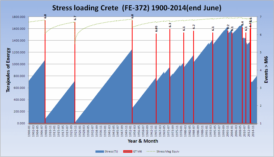
Click the image to enlarge
PS This is intended to allay your fears of a Mag 8 and let you sleep easier!
I'm back (been over to Blighty)
8+ you say. Mm, I wonder. Based on a 500km radius from the 5.1mb and using the Centennial catalogue we get
Date, Lat, Lon, Mag, Location, Depth
1910-02-18T05:09:18.000Z, 36, 24.5, 6.9, Southern Greece, 380.4
1911-04-04T15:43:54.000Z, 36.5, 25.5, 7, Dodecanese Isls. Greece, 329.1
1914-10-03T22:06:34.000Z, 37.5, 32.5, 7.1, Turkey, 485.7
1926-03-18T14:06:16.460Z, 35.787, 29.246, 6.9, E. Mediterranean Sea, 146.6
1926-06-26T19:46:40.950Z, 36.605, 26.888, 7.7, Dodecanese Isls. Greece, 252.5
1948-02-09T12:58:15.000Z, 35.5, 27, 6.9, Dodecanese Islands. Greece, 154.4
1956-07-09T03:11:45.390Z, 36.617, 26.026, 7.8, Dodecanese Isls. Greece, 302.1
1956-07-09T03:24:07.830Z, 36.508, 25.956, 6.9, Dodecanese Isls. Greece, 298.2
1957-04-24T19:10:15.260Z, 36.356, 28.649, 6.9, Dodecanese Isls. Greece, 188.1
1957-04-25T02:25:44.310Z, 36.387, 28.609, 7, Dodecanese Isls. Greece, 191
Basically the area has never had a Mag 8, the closest being a mag 7.8 which yes OK is close. Average depth 272 with none under 146
If that radius is reduced to 250 km then we only get 4 events larger than mag 6.8 with a max of mag 7. Average depth 170 with none under 146
Date, Lat, Lon, Mag, Location, Depth
1926-03-18T14:06:16.460Z, 35.787, 29.246, 6.9, E. Mediterranean Sea, 146.6
1948-02-09T12:58:15.000Z, 35.5, 27, 6.9, Dodecanese Isls. Greece, 154.4
1957-04-24T19:10:15.260Z, 36.356, 28.649, 6.9, Dodecanese Isls. Greece, 188.1
1957-04-25T02:25:44.310Z, 36.387, 28.609, 7, Dodecanese Isls. Greece, 191
At 100 km radius there are NO events > mag 5 but bear in mind the centennial only goes to 2002. At 100km in ANSS there are 18 events up to the end of June 2014 with a max of 5.7
To get a Mag 8+ one has to extend the search radius to 1000km
Date, Lat, Lon, Mag, Location, Depth
1903-08-11T04:32:54.000Z, 36.36, 22.97, 8.3, Southern Greece, 523.1
1912-08-09T01:29:00.000Z, 40.5, 27, 7.6, Turkey, 658.3
1926-06-26T19:46:40.950Z, 36.605, 26.888, 7.7, Dodecanese Isls. Greece, 252.5
1956-07-09T03:11:45.390Z, 36.617, 26.026, 7.8, Dodecanese Isls. Greece, 302.1
1999-08-17T00:01:39.770Z, 40.773, 30.002, 7.6, Turkey, 692.5
The average depth is now 485km with a min of 302.
I would venture to suggest that statistically at least a magnitude 8 in the immediate area of that mag 5.1 is unlikely.
edit on 10/8/2014 by
PuterMan because: To shorten descriptions so they would display better
A stress chart of the FE 370 Crete area. I have not checked if this can be taken as a discrete area but it has to have some validity if it is an FE area.

Click the image to enlarge
PS This is intended to allay your fears of a Mag 8 and let you sleep easier!
edit on 10/8/2014 by PuterMan because: (no reason given)
a reply to: SeekingDepth
Except in this corner of Ireland where it has not been heard of, neither has Sudbury which as far as we are concerned is a small market town in the English county of Suffolk. It is located on the River Stour near the Essex border, and is 60 miles north-east of London.
There is also one in London but I don't think that has nickel either, whatever a nickel is!
These sites are so puffed up with their own importance.
Sorry, I am in a bad mood as I take great exception to sites telling me to download the latest version of something (flash player) so I can view their pictures. I have flash player installed and which version is none of their business.
Sudbury’s landmark Big Nickel is 9 metres (30 ft.) high and recognized around the world.
Except in this corner of Ireland where it has not been heard of, neither has Sudbury which as far as we are concerned is a small market town in the English county of Suffolk. It is located on the River Stour near the Essex border, and is 60 miles north-east of London.
There is also one in London but I don't think that has nickel either, whatever a nickel is!
These sites are so puffed up with their own importance.
Sorry, I am in a bad mood as I take great exception to sites telling me to download the latest version of something (flash player) so I can view their pictures. I have flash player installed and which version is none of their business.
a reply to: PuterMan
Hey welcome back and thanks for the info! Guess those old rumors never die. They say that there has been even a tsunami once here on Crete.
The one in November though was so intense that I can't even imagine what those monster quakes feel like.
Hey welcome back and thanks for the info! Guess those old rumors never die. They say that there has been even a tsunami once here on Crete.
The one in November though was so intense that I can't even imagine what those monster quakes feel like.
originally posted by: Hellas
a reply to: PuterMan
Hey welcome back and thanks for the info! Guess those old rumors never die. They say that there has been even a tsunami once here on Crete.
The one in November though was so intense that I can't even imagine what those monster quakes feel like.
You mean the tsunami from the Santorini eruption 3500 years ago or something more recent?
originally posted by: AlexanderM
originally posted by: Hellas
a reply to: PuterMan
Hey welcome back and thanks for the info! Guess those old rumors never die. They say that there has been even a tsunami once here on Crete.
The one in November though was so intense that I can't even imagine what those monster quakes feel like.
You mean the tsunami from the Santorini eruption 3500 years ago or something more recent?
I don't know. You know, Greek rumors hold for a looong time. So it very well could be the one back then
a reply to: Hellas
According to Mr. Utsu and Ganse and Nelson (1981, 1982), Raid and Myers (1985) there was another M8.3 on 1856/10/12 0:45:- UTC. However these old events are mostly based on intensity, so the location may be a bit off, they show it as just north of Sitia.
Utsu's M8+ Map
location map of some of the other ones above M6 (up to 2008)
source codes for that last one on this page after the maps
this pdf off your link is worth reading renag.unice.fr...
page 8 FUTURE TSUNAMIGENIC EARTHQUAKES, you are good for another 2486-2986 years according to the research, at least from the west end.
And in another 751 years anywhere along the south coast.
Having said that there was one due in 1965 which never occurred, maybe thats where the overdue 70 years comes from, although in fact it is 50 years.
Now where have I heard that 50 years overdue before? um California, NZ's Alpine Fault and there are probably others, thing is earthquakes don't keep to a tight schedule, there is probably a 100 year margin of error, if not more.
What is interesting in that article, and others from your link, they say 350-450AD was a very active period for the Med.
Nowadays were are getting M9ish size quakes all over the place within just 10 years, Sumatra, Chile, Japan
edit on 0800000022122114 by muzzy
because: (no reason given)
Was doing my Energy Graphs for NZ and noted 3 days already where the TTNT energy released
dropped below 10, followed by a M5+ within the Muzzy's Rule period ( 6 days) twice (Kermadecs) and thought we had another in the string.
Problem is those pesky magnitude types, doesn't make the grade according to NZ Geonet Data
look at the Geonet depth too !!! comapred to the others
I tried doing one month where I added GFZ data to the graphs, but it got too messy.
Problem is those pesky magnitude types, doesn't make the grade according to NZ Geonet Data
Prov,Date/Time UTC,Latitude,Longitude,Magnitude,Depth(Km),Location
gfzp,2014-08-11 10:07:34, -29.840, -176.120, 5.5mb, 10.0, Kermadec Isls. Region
emsc,2014-08-11 10:07:34, -29.820, -176.120, 5.2M, 10.0, Kermadec Isls. Region
usgs,2014-08-11 10:07:37, -29.749, -176.073, 5.5mb, 31.7, Kermadec Isls. Region
geonet,2014-08-11 10:07:40, -29.844, -176.918, 4.6ML, 185.0, Kermadec Isls. Region
geoau,2014-08-11 10:07:30, -29.646, -175.704, 5.3mb, 0, Kermadec Isls. Region
gsras,2014-08-11 10:07:37, -29.57, -176.19, 5.5mb, 33, Kermadec Isls. Region
look at the Geonet depth too !!! comapred to the others
I tried doing one month where I added GFZ data to the graphs, but it got too messy.
Not much happening out there eh?
Time for an Update on Ludian, China?
@ 247.26 hours (10.3 days)
mag1= 739 , mag2= 278 , mag3= 45 , mag4= 5 , mag5= 0 , mag6= 1 , total= 1068 , TTNT= 85,008.926
Ludian, China 2014-08-03to2014-08-15 interactive map
one of the weaknesses of the CENC data is, that like EMSC, they only show two decimal points to the lat/long co-ordinates for each event, this ends up showing a very ordered grid like pattern, which in reality isn't very likely.
on the map the shades/opacity of the icons vary according to the number of events at that location, you can see that better in map view rather than Terrain.
for example Lat/Long 27.08,103.39 has 18 events under it
graph below show the aftershock spill to exactly 238:15:16 hrs (240hrs is 10 days, next 17 events were over 240hrs so I took them out)
[pic]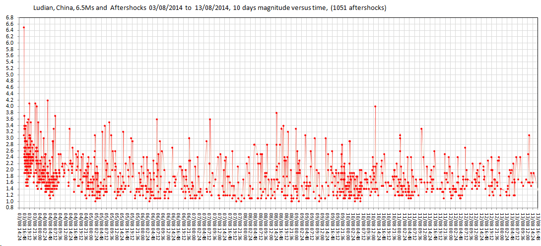 [/pic](click image for
larger version, opens in new tab/window)
[/pic](click image for
larger version, opens in new tab/window)
Time for an Update on Ludian, China?
@ 247.26 hours (10.3 days)
mag1= 739 , mag2= 278 , mag3= 45 , mag4= 5 , mag5= 0 , mag6= 1 , total= 1068 , TTNT= 85,008.926
Ludian, China 2014-08-03to2014-08-15 interactive map
one of the weaknesses of the CENC data is, that like EMSC, they only show two decimal points to the lat/long co-ordinates for each event, this ends up showing a very ordered grid like pattern, which in reality isn't very likely.
on the map the shades/opacity of the icons vary according to the number of events at that location, you can see that better in map view rather than Terrain.
for example Lat/Long 27.08,103.39 has 18 events under it
graph below show the aftershock spill to exactly 238:15:16 hrs (240hrs is 10 days, next 17 events were over 240hrs so I took them out)
[pic]

edit on 08u22622614 by muzzy because: (no reason given)
I was just checking when the last M7+ was, geez been a while alright 23/06/2014
2014 M7 chart
2014 has been a weird year, just that big bunch in April, and the single Rat Islands 7.9 in June.
Having a look at ANSS though, there have been 9 x M6.9's this year, 4 since the Rat Islands which are over and above the ones I already have as 7's, so its not a magtype thingy, I wonder how many of those break the M7 barrier on further investigation through other networks?
BTW I have added the Solomon Is 19/04/2014 M7.5 that I had missed for some reason.
originally posted by: muzzy
Having a look at ANSS though, there have been 9 x M6.9's this year, 4 since the Rat Islands which are over and above the ones I already have as 7's, so its not a magtype thingy, I wonder how many of those break the M7 barrier on further investigation through other networks?
all less magnitudes on GFZ than ANSS, but some of those converted to Ms by CENC show over M7
2014-02-12, 7.3, Ms, Yutian
2014-03-10, 7.0, Ms, The northern coast of California, far from the sea
2014-05-24, 7.1, Ms, Aegean
2014-06-29, 7.2, Ms, South Sandwich Islands region
2014-07-12, 7.2, Ms, Honshu East Coast offshore
2014-07-21, 7.1, mb, Fiji Islands region
edit on 0800000022622614 by muzzy because: (no reason given)
Found 2 more! in 2000
While doing an upgrade on Timeline graphs M7+, looking at data from IRIS and ISC
2000-04-19 23:55:16, 36.52, 27.348, 33.0, MD7.0, DODECANESE ISLANDS
2000-03-21 08:18:00, -18.0, -179.0, n/a, Mb7.1, FIJI ISLANDS REGION
geez, I started this in April 2010, and I'm still finding new (old?) data that qualifies!
new Timeline layout
I suppose you could just look at a list, but with the pointers on the side you can see the time gaps, and when the m8+'s hit (blue or purple markers, purple because its blue overlaid pink)
gets a bit bunched up at times ................. July-Oct 2007 was a shocker
as I mentioned yesterday 2014 is looking a bit sparce, hope that doesn't mean its building for another M9 for someone!!
only 1685 graphs to go!
edit on 08u22822814 by muzzy because: oops forgot to put the link in
new topics
-
Hate makes for strange bedfellows
US Political Madness: 1 hours ago -
Who guards the guards
US Political Madness: 4 hours ago -
Has Tesla manipulated data logs to cover up auto pilot crash?
Automotive Discussion: 6 hours ago -
whistleblower Captain Bill Uhouse on the Kingman UFO recovery
Aliens and UFOs: 11 hours ago
top topics
-
CIA botched its handling of sexual assault allegations, House intel report says
Breaking Alternative News: 16 hours ago, 11 flags -
whistleblower Captain Bill Uhouse on the Kingman UFO recovery
Aliens and UFOs: 11 hours ago, 10 flags -
Who guards the guards
US Political Madness: 4 hours ago, 8 flags -
Hate makes for strange bedfellows
US Political Madness: 1 hours ago, 6 flags -
1980s Arcade
General Chit Chat: 13 hours ago, 5 flags -
Teenager makes chess history becoming the youngest challenger for the world championship crown
Other Current Events: 15 hours ago, 4 flags -
Deadpool and Wolverine
Movies: 14 hours ago, 4 flags -
Has Tesla manipulated data logs to cover up auto pilot crash?
Automotive Discussion: 6 hours ago, 2 flags
active topics
-
"We're All Hamas" Heard at Columbia University Protests
Social Issues and Civil Unrest • 232 • : FlyersFan -
IDF Intel Chief Resigns Over Hamas attack
Middle East Issues • 42 • : TheWoker -
Candidate TRUMP Now Has Crazy Judge JUAN MERCHAN After Him - The Stormy Daniels Hush-Money Case.
Political Conspiracies • 682 • : network dude -
Hate makes for strange bedfellows
US Political Madness • 11 • : Terpene -
Deadpool and Wolverine
Movies • 4 • : FlyersFan -
British TV Presenter Refuses To Use Guest's Preferred Pronouns
Education and Media • 113 • : Consvoli -
Fast Moving Disc Shaped UFO Captured on Camera During Flight from Florida to New York City
Aliens and UFOs • 20 • : MaximusNewmanus -
1980s Arcade
General Chit Chat • 14 • : ATruGod -
MULTIPLE SKYMASTER MESSAGES GOING OUT
World War Three • 94 • : Irishhaf -
Teenager makes chess history becoming the youngest challenger for the world championship crown
Other Current Events • 4 • : Consvoli