It looks like you're using an Ad Blocker.
Please white-list or disable AboveTopSecret.com in your ad-blocking tool.
Thank you.
Some features of ATS will be disabled while you continue to use an ad-blocker.

Quake Watch 2014
page: 81share:
from last nights TV News the reporter said
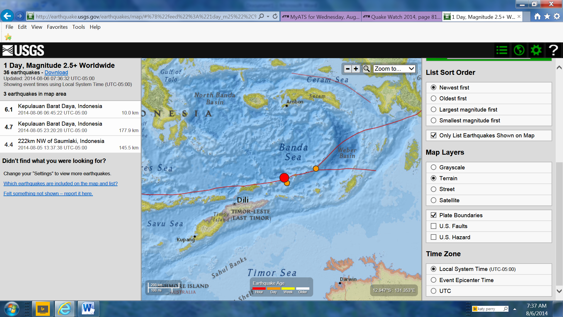
Well maybe, but none of them very big, only 141 total in 14 hours, biggest a 4.2 at the 11:00:00 mark
par for the course though, they take a while to locate them, data could come through in about 2 weeks!
When I did the July update for China the first 7 days were missing, nothing at all!
those 145 aftershocks, map
there have been hundreds of aftershocks
Well maybe, but none of them very big, only 141 total in 14 hours, biggest a 4.2 at the 11:00:00 mark
par for the course though, they take a while to locate them, data could come through in about 2 weeks!
When I did the July update for China the first 7 days were missing, nothing at all!
those 145 aftershocks, map
Just noticed a couple more swarms.
These are in the last 24 hours.
26 quakes in The Geysers/Cobb, Calif.
19 in Portola, Calif.
7 in Calipatria, Calif.
Some twinning going on even in Tenn!
2.0
5km ESE of Ridgely, Tennessee
2014-08-04 16:50:22 UTC
6.9 km
1.5
5km ESE of Ridgely, Tennessee
2014-08-04 16:31:13 UTC
7.3 km
Something is moving somewhere!
WOQ
Had a rare shake here down at the bottom end of Africa today
USGS M5.3 - 6km E of Orkney, South Africa
USGS M5.3 - 6km E of Orkney, South Africa
a reply to: egoli
www.timeslive.co.za...
www.voanews.com...
Some felt Reports ( I edited out the crap)
www.enca.com...
Some mineworkers at Orkney in the North West were trapped following an earth tremor on Tuesday, said emergency workers.
Magnitude 5.3 earthquake shakes central South Africa, rocks Joburg buildings Magnitude 5.3 earthquake shakes central South Africa, rocks Joburg buildings
ER24 spokeswoman Luyanda Majija said they had received reports that the tremor had had a significant impact on one mine.
"Our crew is heading to the mine where miners are reported to trapped at 11 shafts," said Majija.
She could not immediately confirm the name of the mine.
www.timeslive.co.za...
Emergency workers say a man in Orkney died when a wall collapsed on him. Mine shafts in the area were evacuated but there were no injuries reported from underground.
South Africa experiences periodic, medium-sized earthquakes. The same area was hit by 4.9 magnitude tremor two months ago.
The South African Press Association says Tuesday's earthquake lasted for about a minute and was felt in several cities, including Cape Town and Durban.
www.voanews.com...
Some felt Reports ( I edited out the crap)
Dee! 2 hours ago
We felt it strongly here in Potch. I was soo scared I didn't even know what to do - whether to kneel, to stand, or lie down. I can't even remember the position kept. Running outside did not even cross my mind. I just thought of Haiti and immediately started praying...
mphonyane 3 hours ago
felt the tremors in lesotho maseru, which was very scary to feel in mountains
Andre Greeff pmb 3 hours ago
We felt it at the Victoria Country Club on the edge of town.
Wesley Von Clausen.Canada 5 hours ago
Im in Potch, it was quite strong! grew up in the area and its definitely the strongest I felt. but nothing really to worry about if you were above ground, its the miners that have the most to worry about. But guys in JHB! please man.
Nichola Jamison 6 hours ago
Wow! Felt it here in Nigel, on the East Rand. I've never felt something that strong before. Thought the Quality lab was exploding or something.
Marize 6 hours ago
We felt it here in Rustenburg as well, we thought it was the mines...
Conny 6 hours ago
I was in the office in Phokeng, Rustenburg the whole building and everything inside was shaking, thought its blasting at mines
Yolanda 7 hours ago
I felt only some vibrations that I didn't understand I guess that was the quake, Pretoria central.
Mario Pronto 7 hours ago
We felt it here in Maputo, Mozambique!!, high rise buildings were evacuated!
Ndabenhle Ngubane 7 hours ago
Durban CBD as well. I felt it and I thought my colleague was shaking a table. But then we realised that we all experienced it. A bit scary though.
serena Jackson Alicia James 2 hours ago
definitely felt it in Durban CBD, our building 'swayed"
Innocent Khanyile 7 hours ago
In Bloemfontein everyone in the office felt it. We all rushed outside. I was busy on my laptop and sudenly things started shaking in my office.
Dube 7 hours ago
I felt here in Nylstroom, lasted only few seconds.
Amanda le Roux 7 hours ago
We felt the quake in Standerton
Jaydee 7 hours ago
JHB CBD : my chair started shaking for a like a second, I wondered if my office is haunted and then the building started shaking.Scary very scary
Mientjie Esterhuizen 7 hours ago
University of Pretoria - Medical Faculty, yes we felt it and run outside!
Rita Jacobsen 7 hours ago
We felt the tremor/quake today Tuesday 5 August at 12.25 pm in KZN central Drakensberg at the foot of the Cathkin Peak-Champagne Castlemountan range. GPS S29.02.54 E29.24.45 Our bed base is bolted to the wall yet it shook visibly and lasted at least ten seconds. It wasalarming, and the strongest we have felt in this area in 18 years
Ndabenhle Ngubane Rita Jacobsen 7 hours ago
Exactly same time in Durban CBD. That was scary.
Sandile 7 hours ago
i felt a bit dizzy... my colleague thought she lost her marbles when she saw her potplant shaking on her desk ...Dbn CBD
Desire 7 hours ago
heard and felt two massive sounds like explosions this morning around 9am in the West Rand, Roodepoort and were just talking about last year's earth tremor/earthquake and bam a few hours later...
Ree 8 hours ago
60 km east of Orkney, i felt it, still in awe!!
morgan 8 hours ago
Lesotho was shaken as well
www.enca.com...
edit on 08u21621614 by muzzy because: (no reason given)
originally posted by: muzzy
another one ... and bigger
www.earthquakescanada.nrcan.gc.ca...
actually they have 4.3 on the BC/Western Alberta list. So this is the biggest in 12 months, for what is a quite an active area when you look at the data, over the last 12 months 188 quakes ...............
FortStJohn-FortNelson07082013-04082014 interactive map, newest at the top of the list.
wonder what was prior to 07/08/2013????
now I have the area narrowed down I'll have a look, rain/hail predicted here for this morning, I have the time ......
142 km S of Fort Nelson, BC, Canada
Local Time: 14:23:57 MST
Magnitude: 3.9 ML
Latitude: 57.53 North Longitude: 122.87 West
UTC Date and Time: 2014/07/30 21:23:57 UT
www.earthquakescanada.nrcan.gc.ca...
GFZ have that one at 4.2mb
another one ... and bigger
140 km S of Fort Nelson,BC.
Local Time: 10:17:24 MST
Magnitude: 4.2 ML
Latitude: 57.44 North Longitude: 123.56 West
UTC Date and Time: 2014/08/04 17:17:24 UTC
www.earthquakescanada.nrcan.gc.ca...
actually they have 4.3 on the BC/Western Alberta list. So this is the biggest in 12 months, for what is a quite an active area when you look at the data, over the last 12 months 188 quakes ...............
FortStJohn-FortNelson07082013-04082014 interactive map, newest at the top of the list.
wonder what was prior to 07/08/2013????
now I have the area narrowed down I'll have a look, rain/hail predicted here for this morning, I have the time ......
edit on 0800000021621614
by muzzy because: changed the font in the ex tags, hate that olde Roman script, so 1950'
a reply to: muzzy
Later.............
here ya go ...........
FortStJohn-FortNelson Area, 588 events 1986-2014, includes some Mining events or Blasts, which are marked with a special "burst" icon
Largest event in the area
58N, 54S
125.0W, 120W
was
Date/Time UTC: 21/03/1986 23:56:19
Lat: 54.24 Long: -122
Magnitude: 5.4
Depth: 10 km
Location: 61 km NE from Prince George
at the other end of area to the recent quakes 2014
M3.8 - 15km W of Greater Sudbury, Canada
Event Time
1. 2014-08-05 18:15:31 UTC
2. 2014-08-05 14:15:31 UTC-04:00 at epicenter
3. 2014-08-05 13:15:31 UTC-05:00 system time
Location
46.485°N 81.192°W depth=5.4km (3.4mi)
Nearby Cities
1. 15km (9mi) W of Greater Sudbury, Canada
2. 111km (69mi) E of Elliot Lake, Canada
3. 134km (83mi) W of North Bay, Canada
4. 158km (98mi) SW of Temiskaming Shores, Canada
5. 339km (211mi) NNW of Toronto
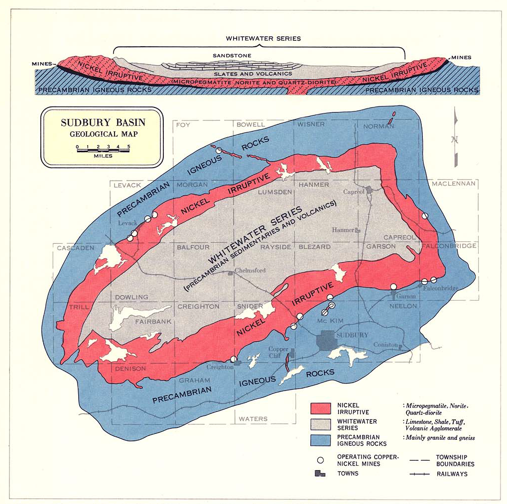
The Sudbury Basin, also known as Sudbury Structure or the Sudbury Nickel Irruptive, is a major geologic structure in Ontario, Canada. It is the second-largest known impact crater or astrobleme on Earth, as well as one of the oldest.[1]
The basin is located on the Canadian Shield in the city of Greater Sudbury, Ontario. The former municipalities of Rayside-Balfour and Valley East lie within the Sudbury Basin, which is referred to locally as "The Valley". The urban core of the former city of Sudbury lies on the southern outskirts of the basin.
The Sudbury Basin is located near a number of other geological structures, including the Temagami Magnetic Anomaly, the Lake Wanapitei impact crater, the western end of the Ottawa-Bonnechere Graben, the Grenville Front Tectonic Zone and the eastern end of the Great Lakes Tectonic Zone, although none of the structures are directly related to each other in the sense of resulting from the same geophysical processes.
en.wikipedia.org...
www.cbc.ca...
dataPath=/photogallery/documentaries/gallery_646/xml/gallery_646.xml
The Sudbury Structure is a famous geological feature that hosts one of the largest concentrations of nickel-copper sulphides in the world.
The Sudbury Basin, 27 km (17 mi.) wide, 60 km (37 mi.) long and 15 km (10 mi.) deep, is believed to have been formed by a meteorite impact 1.8 billion years ago.
Sudbury is home to the largest integrated mining complex in the world.
There are 5,000 km (3,107 mi.) of mining tunnels under the Sudbury area. Placed end-to-end, you could drive from Sudbury to Vancouver underground. Sudbury’s landmark Big Nickel is 9 metres (30 ft.) high and recognized around the world.
www.comeexplorecanada.com...
www3.laurentian.ca...
Wonder if any of the miners felt this quake or if it could have been caused by mining?
Event Time
1. 2014-08-05 18:15:31 UTC
2. 2014-08-05 14:15:31 UTC-04:00 at epicenter
3. 2014-08-05 13:15:31 UTC-05:00 system time
Location
46.485°N 81.192°W depth=5.4km (3.4mi)
Nearby Cities
1. 15km (9mi) W of Greater Sudbury, Canada
2. 111km (69mi) E of Elliot Lake, Canada
3. 134km (83mi) W of North Bay, Canada
4. 158km (98mi) SW of Temiskaming Shores, Canada
5. 339km (211mi) NNW of Toronto
The Sudbury Basin, also known as Sudbury Structure or the Sudbury Nickel Irruptive, is a major geologic structure in Ontario, Canada. It is the second-largest known impact crater or astrobleme on Earth, as well as one of the oldest.[1]
The basin is located on the Canadian Shield in the city of Greater Sudbury, Ontario. The former municipalities of Rayside-Balfour and Valley East lie within the Sudbury Basin, which is referred to locally as "The Valley". The urban core of the former city of Sudbury lies on the southern outskirts of the basin.
The Sudbury Basin is located near a number of other geological structures, including the Temagami Magnetic Anomaly, the Lake Wanapitei impact crater, the western end of the Ottawa-Bonnechere Graben, the Grenville Front Tectonic Zone and the eastern end of the Great Lakes Tectonic Zone, although none of the structures are directly related to each other in the sense of resulting from the same geophysical processes.
en.wikipedia.org...
www.cbc.ca...
dataPath=/photogallery/documentaries/gallery_646/xml/gallery_646.xml
The Sudbury Structure is a famous geological feature that hosts one of the largest concentrations of nickel-copper sulphides in the world.
The Sudbury Basin, 27 km (17 mi.) wide, 60 km (37 mi.) long and 15 km (10 mi.) deep, is believed to have been formed by a meteorite impact 1.8 billion years ago.
Sudbury is home to the largest integrated mining complex in the world.
There are 5,000 km (3,107 mi.) of mining tunnels under the Sudbury area. Placed end-to-end, you could drive from Sudbury to Vancouver underground. Sudbury’s landmark Big Nickel is 9 metres (30 ft.) high and recognized around the world.
www.comeexplorecanada.com...
www3.laurentian.ca...
Wonder if any of the miners felt this quake or if it could have been caused by mining?
20 minutes ago;
www.emsc-csem.org...
This is where LISS falls down, still to arrive and be shown on RAO LISS gone tomorrow
Raoul IRIS siesmo (good for 9 days)
Date/Time UTC 2014/08/06 04:19:03.2
Latitude 29.97 S
Longitude 178.85 W
Depth 397.0 Km
Magnitude M 5.4
Region KERMADEC ISLANDS, NEW ZEALAND
www.emsc-csem.org...
This is where LISS falls down, still to arrive and be shown on RAO LISS gone tomorrow
Raoul IRIS siesmo (good for 9 days)
originally posted by: SeekingDepth
Wonder if any of the miners felt this quake or if it could have been caused by mining?
No doubt
charming phrase used a lot by Canadians
another one is "I'm good", which means " no thanks"
that's the answer to "do you want some more coffee/icecream/toast/(enter anything here)?"
Yesterday Lakeview, Oregon/Nevada had a swarm of 9 quakes.
Today in the last 23 hours it has increased to 35.
The Geysers/Cobb, California was 26 yesterday.
Today in the last 23 hours it's 31.
Another in Tennessee too.
M 2.0 - 4km NW of East Brainerd, Tennessee
Time 2014-08-05 20:00:06 UTC
Location 35.020°N 85.193°W
Depth 10.1km
11 more in Washington state also.
WOQ
edit on 6-8-2014 by wasobservingquietly because: (no reason given)
Anyone else having trouble accessing the USGS site? It keeps timing out for me on FF & Chrome. It's not the end of the world, I can still check the
EMSC, but just not for the smaller US ones.
Morning, USGS working good for me.
M6.1 - Kepulauan Barat Daya, Indonesia 2014-08-06 11:45:22 UTC
Event Time
1. 2014-08-06 11:45:22 UTC
2. 2014-08-06 20:45:22 UTC+09:00 at epicenter
3. 2014-08-06 06:45:22 UTC-05:00 system time
Location
7.273°S 128.046°E depth=10.0km (6.2mi)
Nearby Cities
1. 307km (191mi) ENE of Dili, East Timor
2. 395km (245mi) S of Ambon, Indonesia
3. 402km (250mi) ENE of Atambua, Indonesia
4. 446km (277mi) SSW of Amahai, Indonesia
5. 307km (191mi) ENE of Dili, East Timor
edit on 6-8-2014 by SeekingDepth because: Added Pic
Something is building here !!!!
earthquake.usgs.gov...
earthquake.usgs.gov...
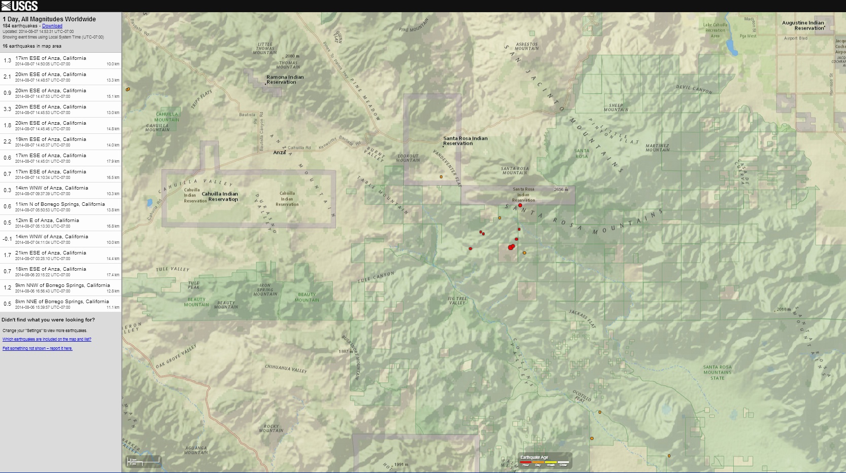
files.abovetopsecret.com...
M3.2 and
M3.3 - 20km ESE of Anza, California
Event Time
2014-08-07 21:45:53 UTC
2014-08-07 14:45:53 UTC-07:00 at epicenter
2014-08-07 14:45:53 UTC-07:00 system time
Location
33.482°N 116.473°W depth=13.0km (8.1mi)
Nearby Cities
20km (12mi) ESE of Anza, California
25km (16mi) SW of La Quinta, California
28km (17mi) SSW of Palm Desert, California
29km (18mi) S of Rancho Mirage, California
408km (254mi) W of Phoenix, Arizona
So far quakes listed by USGS are
0.8
21km ESE of Anza, California
2014-08-07 14:51:39 UTC-07:0017.3 km
1.1
17km ESE of Anza, California
2014-08-07 14:50:05 UTC-07:004.5 km
2.1
20km ESE of Anza, California
2014-08-07 14:48:57 UTC-07:0013.3 km
0.9
20km ESE of Anza, California
2014-08-07 14:47:53 UTC-07:0015.1 km
3.3
20km ESE of Anza, California
2014-08-07 14:45:53 UTC-07:0013.0 km
1.8
20km ESE of Anza, California
2014-08-07 14:45:46 UTC-07:0014.8 km
2.2
19km ESE of Anza, California
2014-08-07 14:45:37 UTC-07:0014.0 km
0.6
17km ESE of Anza, California
2014-08-07 14:45:01 UTC-07:0016.6 km
0.7
17km ESE of Anza, California
2014-08-07 14:10:34 UTC-07:0016.5 km
0.5
12km E of Anza, California
2014-08-07 05:13:30 UTC-07:0016.8 km
1.7
21km ESE of Anza, California
2014-08-07 03:25:10 UTC-07:0014.4 km
0.7
18km ESE of Anza, California
2014-08-06 20:15:22 UTC-07:0017.4 k
but should be this
0.8
21km ESE of Anza, California
2014-08-07 14:51:39 UTC-07:0017.3 km
1.1
17km ESE of Anza, California
2014-08-07 14:50:05 UTC-07:004.5 km
2.1
20km ESE of Anza, California
2014-08-07 14:48:57 UTC-07:0013.3 km
0.9
20km ESE of Anza, California
2014-08-07 14:47:53 UTC-07:0015.1 km
3.3
20km ESE of Anza, California
2014-08-07 14:45:53 UTC-07:0013.0 km
3.2
20km ESE of Anza, California
2014-08-07 14:45:46 UTC-07:0014.8 km
2.2
19km ESE of Anza, California
2014-08-07 14:45:37 UTC-07:0014.0 km
0.6
17km ESE of Anza, California
2014-08-07 14:45:01 UTC-07:0016.6 km
0.7
17km ESE of Anza, California
2014-08-07 14:10:34 UTC-07:0016.5 km
0.5
12km E of Anza, California
2014-08-07 05:13:30 UTC-07:0016.8 km
1.7
21km ESE of Anza, California
2014-08-07 03:25:10 UTC-07:0014.4 km
0.7
18km ESE of Anza, California
2014-08-06 20:15:22 UTC-07:0017.4 k
earthquake.usgs.gov...
earthquake.usgs.gov...
files.abovetopsecret.com...
M3.2 and
M3.3 - 20km ESE of Anza, California
Event Time
2014-08-07 21:45:53 UTC
2014-08-07 14:45:53 UTC-07:00 at epicenter
2014-08-07 14:45:53 UTC-07:00 system time
Location
33.482°N 116.473°W depth=13.0km (8.1mi)
Nearby Cities
20km (12mi) ESE of Anza, California
25km (16mi) SW of La Quinta, California
28km (17mi) SSW of Palm Desert, California
29km (18mi) S of Rancho Mirage, California
408km (254mi) W of Phoenix, Arizona
So far quakes listed by USGS are
0.8
21km ESE of Anza, California
2014-08-07 14:51:39 UTC-07:0017.3 km
1.1
17km ESE of Anza, California
2014-08-07 14:50:05 UTC-07:004.5 km
2.1
20km ESE of Anza, California
2014-08-07 14:48:57 UTC-07:0013.3 km
0.9
20km ESE of Anza, California
2014-08-07 14:47:53 UTC-07:0015.1 km
3.3
20km ESE of Anza, California
2014-08-07 14:45:53 UTC-07:0013.0 km
1.8
20km ESE of Anza, California
2014-08-07 14:45:46 UTC-07:0014.8 km
2.2
19km ESE of Anza, California
2014-08-07 14:45:37 UTC-07:0014.0 km
0.6
17km ESE of Anza, California
2014-08-07 14:45:01 UTC-07:0016.6 km
0.7
17km ESE of Anza, California
2014-08-07 14:10:34 UTC-07:0016.5 km
0.5
12km E of Anza, California
2014-08-07 05:13:30 UTC-07:0016.8 km
1.7
21km ESE of Anza, California
2014-08-07 03:25:10 UTC-07:0014.4 km
0.7
18km ESE of Anza, California
2014-08-06 20:15:22 UTC-07:0017.4 k
but should be this
0.8
21km ESE of Anza, California
2014-08-07 14:51:39 UTC-07:0017.3 km
1.1
17km ESE of Anza, California
2014-08-07 14:50:05 UTC-07:004.5 km
2.1
20km ESE of Anza, California
2014-08-07 14:48:57 UTC-07:0013.3 km
0.9
20km ESE of Anza, California
2014-08-07 14:47:53 UTC-07:0015.1 km
3.3
20km ESE of Anza, California
2014-08-07 14:45:53 UTC-07:0013.0 km
3.2
20km ESE of Anza, California
2014-08-07 14:45:46 UTC-07:0014.8 km
2.2
19km ESE of Anza, California
2014-08-07 14:45:37 UTC-07:0014.0 km
0.6
17km ESE of Anza, California
2014-08-07 14:45:01 UTC-07:0016.6 km
0.7
17km ESE of Anza, California
2014-08-07 14:10:34 UTC-07:0016.5 km
0.5
12km E of Anza, California
2014-08-07 05:13:30 UTC-07:0016.8 km
1.7
21km ESE of Anza, California
2014-08-07 03:25:10 UTC-07:0014.4 km
0.7
18km ESE of Anza, California
2014-08-06 20:15:22 UTC-07:0017.4 k
edit on 7/30/2012 by dreamfox1 because: (no reason given)
update to aftershocks of Yunnan 6.5Ms: muzzy
72hr Timeline graph
 (click image for larger version,
opens in new tab/window)
(click image for larger version,
opens in new tab/window)
interactive map @ 87hrs
72hr Timeline graph

interactive map @ 87hrs
edit on 08u21821814 by muzzy because: missed a l in the tag
Up to date quake list of the area in question still missing that 3.2 they deleted.
0.9
19km ESE of Anza, California
2014-08-07 18:26:05 UTC-07:008.1 km
0.4
20km ESE of Anza, California
2014-08-07 18:06:38 UTC-07:0021.3 km
0.4
21km ESE of Anza, California
2014-08-07 16:50:48 UTC-07:0017.0 km
0.1
16km ESE of Anza, California
2014-08-07 16:47:08 UTC-07:0015.6 km
0.6
17km ESE of Anza, California
2014-08-07 16:09:57 UTC-07:0016.6 km
0.3
20km ESE of Anza, California
2014-08-07 15:45:11 UTC-07:0014.4 km
1.0
19km ESE of Anza, California
2014-08-07 15:43:09 UTC-07:0015.5 km
0.3
20km ESE of Anza, California
2014-08-07 15:42:10 UTC-07:0014.4 km
0.6
19km ESE of Anza, California
2014-08-07 15:29:26 UTC-07:0015.3 km
0.6
20km ESE of Anza, California
2014-08-07 15:27:04 UTC-07:0015.4 km
0.0
19km ESE of Anza, California
2014-08-07 15:23:58 UTC-07:0015.3 km
0.4
19km ESE of Anza, California
2014-08-07 15:04:32 UTC-07:0014.3 km
0.3
19km ESE of Anza, California
2014-08-07 15:03:49 UTC-07:0015.3 km
0.8
20km ESE of Anza, California
2014-08-07 14:51:39 UTC-07:0015.1 km
1.0
20km ESE of Anza, California
2014-08-07 14:50:05 UTC-07:0015.1 km
2.1
20km ESE of Anza, California
2014-08-07 14:48:57 UTC-07:0014.2 km
0.8
19km ESE of Anza, California
2014-08-07 14:47:53 UTC-07:0014.6 km
3.3
20km ESE of Anza, California
2014-08-07 14:45:53 UTC-07:0014.8 km
2.5
20km ESE of Anza, California
2014-08-07 14:45:46 UTC-07:0014.3 km
0.8
20km ESE of Anza, California
2014-08-07 14:45:37 UTC-07:0015.4 km
0.6
17km ESE of Anza, California
2014-08-07 14:45:01 UTC-07:0016.6 km
0.7
17km ESE of Anza, California
2014-08-07 14:10:34 UTC-07:0016.5 km
1.7
21km ESE of Anza, California
2014-08-07 03:25:10 UTC-07:0014.4 km
0.7
18km ESE of Anza, California
2014-08-06 20:15:22 UTC-07:0017.4 k
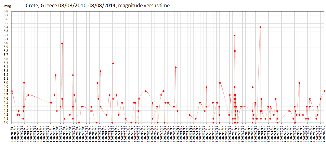
mb 4.8 Region CRETE, GREECE
Date time 2014-08-08 08:20:45.8 UTC Location 34.54 N ; 24.77 E Depth 10 km
Distances 393 km S of Athens, Greece / pop: 729,137 / local time: 11:20:45.8 2014-08-08 94 km S of Irákleion, Greece / pop: 137,154 / local time: 11:20:45.8 2014-08-08 58 km S of Tympáki, Greece / pop: 4,923 / local time: 11:20:45.8 2014-08-08
emsc
That was a very strange quake.. I felt it like somebody was pushing me hard. Started with a tiny sway and then one quick jerk. People in the testimonies talk about a circular motion which is odd.
No aftershocks, nothing
edit on 8-8-2014 by Hellas because: (no reason given)
a reply to: Hellas
so where does that one fit in the bigger picture for Crete???
i had a look back 4 years,
this would make it the 17th= biggest quake within that time period
EMSC data M4+
 (click image for larger version, opens
in new tab/window)
(click image for larger version, opens
in new tab/window)
as it would happen there was a 4.8 on 08/08/2010 also, 31.6km WNW of this one
so where does that one fit in the bigger picture for Crete???
i had a look back 4 years,
this would make it the 17th= biggest quake within that time period
EMSC data M4+

edit on 08u22022014 by muzzy because: (no reason given)
as it would happen there was a 4.8 on 08/08/2010 also, 31.6km WNW of this one
edit on 0800000022022014 by muzzy because: missed a 0
new topics
-
Israel attacking Iran again.
Middle East Issues: 1 hours ago -
Michigan school district cancels lesson on gender identity and pronouns after backlash
Education and Media: 1 hours ago -
When an Angel gets his or her wings
Religion, Faith, And Theology: 1 hours ago -
Comparing the theology of Paul and Hebrews
Religion, Faith, And Theology: 2 hours ago -
Pentagon acknowledges secret UFO project, the Kona Blue program | Vargas Reports
Aliens and UFOs: 3 hours ago -
Boston Dynamics say Farewell to Atlas
Science & Technology: 3 hours ago -
I hate dreaming
Rant: 4 hours ago -
Man sets himself on fire outside Donald Trump trial
Mainstream News: 6 hours ago -
Biden says little kids flip him the bird all the time.
Politicians & People: 6 hours ago -
The Democrats Take Control the House - Look what happened while you were sleeping
US Political Madness: 7 hours ago
top topics
-
The Democrats Take Control the House - Look what happened while you were sleeping
US Political Madness: 7 hours ago, 17 flags -
In an Historic First, In N Out Burger Permanently Closes a Location
Mainstream News: 9 hours ago, 14 flags -
A man of the people
Medical Issues & Conspiracies: 14 hours ago, 10 flags -
Biden says little kids flip him the bird all the time.
Politicians & People: 6 hours ago, 8 flags -
Man sets himself on fire outside Donald Trump trial
Mainstream News: 6 hours ago, 7 flags -
Pentagon acknowledges secret UFO project, the Kona Blue program | Vargas Reports
Aliens and UFOs: 3 hours ago, 5 flags -
4 plans of US elites to defeat Russia
New World Order: 16 hours ago, 4 flags -
Sheetz facing racial discrimination lawsuit for considering criminal history in hiring
Social Issues and Civil Unrest: 7 hours ago, 3 flags -
Michigan school district cancels lesson on gender identity and pronouns after backlash
Education and Media: 1 hours ago, 3 flags -
Boston Dynamics say Farewell to Atlas
Science & Technology: 3 hours ago, 3 flags
active topics
-
The Acronym Game .. Pt.3
General Chit Chat • 7733 • : CCoburn -
A man of the people
Medical Issues & Conspiracies • 11 • : chr0naut -
Post A Funny (T&C Friendly) Pic Part IV: The LOL awakens!
General Chit Chat • 7128 • : baddmove -
Michigan school district cancels lesson on gender identity and pronouns after backlash
Education and Media • 5 • : MetalThunder -
Thousands Of Young Ukrainian Men Trying To Flee The Country To Avoid Conscription And The War
Other Current Events • 52 • : TheMisguidedAngel -
-@TH3WH17ERABB17- -Q- ---TIME TO SHOW THE WORLD--- -Part- --44--
Dissecting Disinformation • 547 • : 777Vader -
Israel attacking Iran again.
Middle East Issues • 14 • : Solvedit -
The Democrats Take Control the House - Look what happened while you were sleeping
US Political Madness • 64 • : KrustyKrab -
Candidate TRUMP Now Has Crazy Judge JUAN MERCHAN After Him - The Stormy Daniels Hush-Money Case.
Political Conspiracies • 403 • : Threadbarer -
Cat Movies
Movies • 19 • : 5thHead