It looks like you're using an Ad Blocker.
Please white-list or disable AboveTopSecret.com in your ad-blocking tool.
Thank you.
Some features of ATS will be disabled while you continue to use an ad-blocker.

Quake Watch 2014
page: 78share:
a reply to: SeekingDepth
Mmm, but is it?
Something not right there I think. The data is incomplete on USGS, but GFZ is also still after this time Automatic and EMSC is not yet reviewed. USGS says it is manual (i.e. not automatic) but does not say it is reviewed.
We shall have to wait to see until staff get back in on Monday and relieve the students.
Nearest public seismo
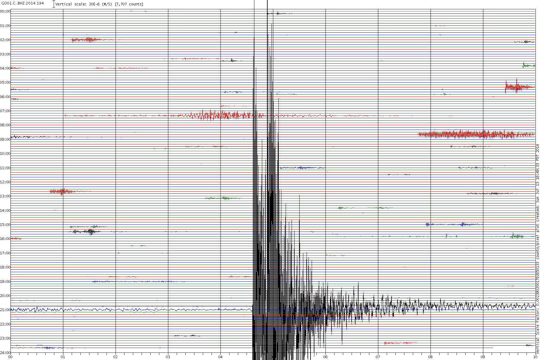
Click the image to enlarge
But look at the scale - only 7,700 counts. I don't think this is a mag 6 but I have not checked to see how far the station is from the quake yet.
Click the image to enlarge
Only just over 1 x 10⁻⁵ m/s = 1+ mm (if the maths is working at this time of night)
Mmm, but is it?
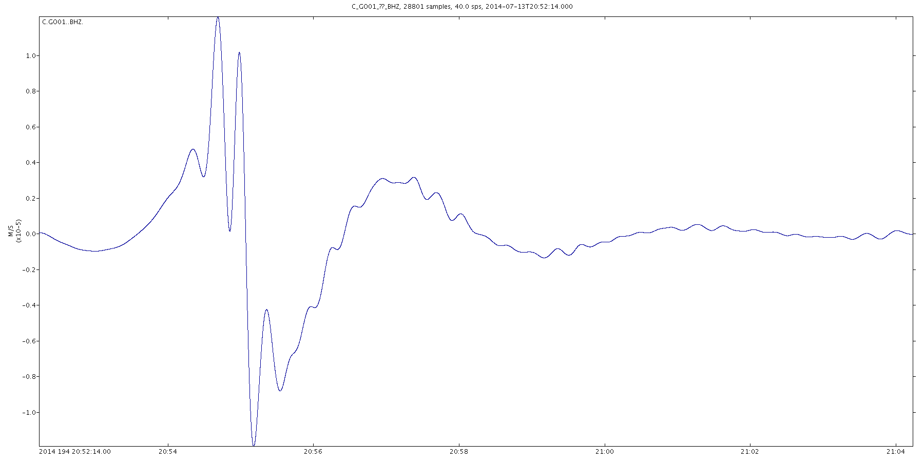
Prov,Date/Time UTC,Latitude,Longitude,Magnitude,Depth(Km),Location
gfzp,2014-07-13 20:54:14, -20.200, -70.230, 5.5 Mw, 29.0, Nr. Coast Of Nthn Chile
usgs,2014-07-13 20:54:14, -20.244, -70.356, 6.1 Mwp, 35.6, Nr. Coast Of Nthn Chile (122)
emsc,2014-07-13 20:54:15, -20.200, -70.220, 5.3 Mw, 44.0, Offshore Tarapaca. Chile
Something not right there I think. The data is incomplete on USGS, but GFZ is also still after this time Automatic and EMSC is not yet reviewed. USGS says it is manual (i.e. not automatic) but does not say it is reviewed.
We shall have to wait to see until staff get back in on Monday and relieve the students.
Nearest public seismo

Click the image to enlarge
But look at the scale - only 7,700 counts. I don't think this is a mag 6 but I have not checked to see how far the station is from the quake yet.

Click the image to enlarge
Only just over 1 x 10⁻⁵ m/s = 1+ mm (if the maths is working at this time of night)
edit on 13/7/2014 by PuterMan because: (no reason given)
A nice little swarm in Lakeview, Oregon today!
1.3
74km SE of Lakeview, Oregon
2014-07-14 00:08:14 UTC
9.0 km
1.4
72km SE of Lakeview, Oregon
2014-07-13 23:52:54 UTC
1.5 km
1.3
73km SE of Lakeview, Oregon
2014-07-13 23:51:48 UTC
10.1 km
1.5
70km SE of Lakeview, Oregon
2014-07-13 19:47:52 UTC
3.9 km
1.7
71km SE of Lakeview, Oregon
2014-07-13 18:06:41 UTC
0.9 km
2.0
74km SE of Lakeview, Oregon
2014-07-13 14:17:58 UTC
0.0 km
2.1
67km ESE of Lakeview, Oregon
2014-07-13 12:41:29 UTC
6.4 km
2.0
71km SE of Lakeview, Oregon
2014-07-13 11:07:37 UTC
0.0 km
2.1
68km ESE of Lakeview, Oregon
2014-07-13 11:00:38 UTC
0.0 km
1.3
71km SE of Lakeview, Oregon
2014-07-13 10:37:28 UTC
6.8 km
1.3
68km ESE of Lakeview, Oregon
2014-07-13 06:58:32 UTC
3.4 km
3.0
70km SE of Lakeview, Oregon
2014-07-13 06:08:05 UTC
0.2 km
2.2
70km SE of Lakeview, Oregon
2014-07-13 04:14:39 UTC
0.1 km
All different depths & even no depth!!!
All of the ones 1.5 & under, except for one,
are deeper than the stronger ones! Huh????
WOQ
1.3
74km SE of Lakeview, Oregon
2014-07-14 00:08:14 UTC
9.0 km
1.4
72km SE of Lakeview, Oregon
2014-07-13 23:52:54 UTC
1.5 km
1.3
73km SE of Lakeview, Oregon
2014-07-13 23:51:48 UTC
10.1 km
1.5
70km SE of Lakeview, Oregon
2014-07-13 19:47:52 UTC
3.9 km
1.7
71km SE of Lakeview, Oregon
2014-07-13 18:06:41 UTC
0.9 km
2.0
74km SE of Lakeview, Oregon
2014-07-13 14:17:58 UTC
0.0 km
2.1
67km ESE of Lakeview, Oregon
2014-07-13 12:41:29 UTC
6.4 km
2.0
71km SE of Lakeview, Oregon
2014-07-13 11:07:37 UTC
0.0 km
2.1
68km ESE of Lakeview, Oregon
2014-07-13 11:00:38 UTC
0.0 km
1.3
71km SE of Lakeview, Oregon
2014-07-13 10:37:28 UTC
6.8 km
1.3
68km ESE of Lakeview, Oregon
2014-07-13 06:58:32 UTC
3.4 km
3.0
70km SE of Lakeview, Oregon
2014-07-13 06:08:05 UTC
0.2 km
2.2
70km SE of Lakeview, Oregon
2014-07-13 04:14:39 UTC
0.1 km
All different depths & even no depth!!!
All of the ones 1.5 & under, except for one,
are deeper than the stronger ones! Huh????
WOQ
F-E Region: Mindanao, Philippines
Time: 2014-07-14 07:59:57.7 UTC
Magnitude: 6.1Mw
Epicenter: 126.44°E 5.87°N
Depth: 10 km
Status: A - automatic
geofon.gfz-potsdam.de...
6.2Mw on GFZ MT
geofon.gfz-potsdam.de...
Did a 13 day download off QVS Datapro the other night in antisipation of having some free time early morning to update my NZEQ Blog since July 1st, but the hotle wi-fi is working at Dial-up speed for the last few days, hopeless.
So its air-condioning versus hispeed wifi
a/c wins
muzzy in Edmonton
2014-07-16 00:28:56 M4.6 62.66°N 127.78°W 10 NW Territories - Nunavut,
Canada
2014-07-16 00:20:09 M4.5 62.68°N 127.70°W 10 NW Territories - Nunavut, Canada
GFZ
014/07/16 00:28:54 62.60 -127.96 7.0 M5.0 279 km NNE of Watson Lk.,YT
2014/07/16 00:20:07 62.62 -127.96 1.0 M5.0 282 km NNE of Watson Lk.,YT
EQ Canada
muzzy in Calgary now
2014-07-16 00:20:09 M4.5 62.68°N 127.70°W 10 NW Territories - Nunavut, Canada
GFZ
014/07/16 00:28:54 62.60 -127.96 7.0 M5.0 279 km NNE of Watson Lk.,YT
2014/07/16 00:20:07 62.62 -127.96 1.0 M5.0 282 km NNE of Watson Lk.,YT
EQ Canada
muzzy in Calgary now
edit on 07u19619614 by muzzy because: links
M5.8 - 98km NNW of Yakutat, Alaska
UPGRADED to a 6.0
2014-07-17 11:49:32 UTC
Location
60.373°N 140.345°W
depth=0.6km (0.4mi)
Changed to Depth 14.8km
Nearby Cities
98km (61mi) NNW of Yakutat, Alaska
292km (181mi) W of Whitehorse, Canada
408km (254mi) NW of Juneau, Alaska
517km (321mi) E of Knik-Fairview, Alaska
528km (328mi) E of Anchorage, Alaska
earthquake.usgs.gov...
Looks Like AK is waking up kind of abruptly this morning!
* eyeballs Southeast Alaska then looks at the Anchorage area *
Since this EQ:
2.7 82km NNW of Yakutat, Alaska 2014-07-17 05:17:09 UTC-07:00 0.0 km
2.5 101km NNW of Yakutat, Alaska 2014-07-17 05:15:31 UTC-07:00 0.5 km
2.7 91km NNW of Yakutat, Alaska 2014-07-17 05:10:06 UTC-07:00 0.5 km
3.1 98km NNW of Yakutat, Alaska 2014-07-17 05:08:28 UTC-07:00 0.1 km
2.7 92km NNW of Yakutat, Alaska 2014-07-17 05:07:30 UTC-07:00 0.0 km
2.9 96km N of Yakutat, Alaska 2014-07-17 05:05:45 UTC-07:00 0.3 km
2.6 95km NNW of Yakutat, Alaska 2014-07-17 05:04:33 UTC-07:00 5.7 km
2.7 95km NNW of Yakutat, Alaska 2014-07-17 05:01:49 UTC-07:00 0.8 km
Aftershocks? They seem placed all over that area now. Lots of them.
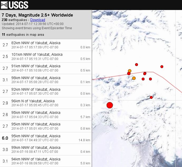
Glacier related maybe?
UPGRADED to a 6.0
2014-07-17 11:49:32 UTC
Location
60.373°N 140.345°W
depth=0.6km (0.4mi)
Changed to Depth 14.8km
Nearby Cities
98km (61mi) NNW of Yakutat, Alaska
292km (181mi) W of Whitehorse, Canada
408km (254mi) NW of Juneau, Alaska
517km (321mi) E of Knik-Fairview, Alaska
528km (328mi) E of Anchorage, Alaska
earthquake.usgs.gov...
Looks Like AK is waking up kind of abruptly this morning!
* eyeballs Southeast Alaska then looks at the Anchorage area *
Since this EQ:
2.7 82km NNW of Yakutat, Alaska 2014-07-17 05:17:09 UTC-07:00 0.0 km
2.5 101km NNW of Yakutat, Alaska 2014-07-17 05:15:31 UTC-07:00 0.5 km
2.7 91km NNW of Yakutat, Alaska 2014-07-17 05:10:06 UTC-07:00 0.5 km
3.1 98km NNW of Yakutat, Alaska 2014-07-17 05:08:28 UTC-07:00 0.1 km
2.7 92km NNW of Yakutat, Alaska 2014-07-17 05:07:30 UTC-07:00 0.0 km
2.9 96km N of Yakutat, Alaska 2014-07-17 05:05:45 UTC-07:00 0.3 km
2.6 95km NNW of Yakutat, Alaska 2014-07-17 05:04:33 UTC-07:00 5.7 km
2.7 95km NNW of Yakutat, Alaska 2014-07-17 05:01:49 UTC-07:00 0.8 km
Aftershocks? They seem placed all over that area now. Lots of them.
Glacier related maybe?
edit on 17-7-2014 by Darkblade71 because: (no reason given)
a reply to: Darkblade71
Yikes! Yakutat Terrain Earthquake isn’t this Alaska’s “Squeezebox”
The Big One started on this area per this video.
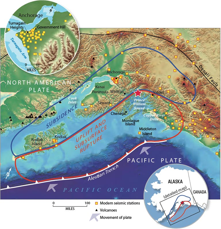
earthquake.usgs.gov...
Yikes! Yakutat Terrain Earthquake isn’t this Alaska’s “Squeezebox”
The Big One started on this area per this video.
earthquake.usgs.gov...
a reply to: SeekingDepth
That was excellent information!
If I could star you twice for that I would!
That was excellent information!
If I could star you twice for that I would!
a reply to: SeekingDepth
That video is exceptional info. Truly something to watch for in the coming days/weeks/months. Not sure of the time span between the quake of today and the mega quakes of the past. I think Fairbanks and Juneau are both places to watch.
Here is another article about the location of the quake today near Mount Logan.
Mount Logan
a reply to: SeekingDepth
Thanks. The first item is particularly revealing, especially the upping of the potential threat for Cascadia to Mag 9.3, something that does not surprise those of us who study these things.
Some of the raises are I think 'precautionary' and maybe designed to wake up the nuclear industry - in particular the New Madrid areas as there are conflicting views on potential for seismicity here.
Possible Mag 6 in Tonga
GFZ data only on automatic so far
Location in Google Maps
Derived from Event Data Source: USGS
Powered by QVSData
GFZ data only on automatic so far
edit on 19/7/2014 by PuterMan because: Having a bad tag day
Magnitude 6.0 - Tonga Islands (173)
Location in Google Maps
- Date-Time: Saturday, July 19, 2014 @ 12:27:09 UTC
- Earthquake location: 15.799°S, 174.404°W,
- Earthquake depth: 219.8 km
- Distances:
72km (44mi) WNW of Hihifo, Tonga
357km (221mi) SW of Apia, Samoa
427km (265mi) WSW of Tafuna, American Samoa
432km (268mi) WSW of Pago Pago, American Samoa
596km (370mi) N of Nuku`alofa, Tonga
- Event ID: usb000rujq
Derived from Event Data Source: USGS
Powered by QVSData
edit on 19/7/2014 by PuterMan because: USGS data now in
Not awake today folks? I was out when this happened and expected it had been picked up!
Location in Google Maps
Derived from Event Data Source: USGS
Powered by QVSData
Magnitude 6.0 - Owen Fracture Zone Region (740)
Location in Google Maps
- Date-Time: Saturday, July 19, 2014 @ 14:14:01 UTC
- Earthquake location: 11.752°N, 57.563°E,
- Earthquake depth: 10.0 km
- Distances:
396km (246mi) ESE of Tamrida, Yemen
692km (429mi) SSE of Salalah, Oman
708km (439mi) E of Bereeda, Somalia
779km (484mi) ENE of Bandarbeyla, Somalia
1317km (818mi) S of Muscat, Oman
- Event ID: usb000ruks
Derived from Event Data Source: USGS
Powered by QVSData
Heading through the Canadian Rockies now, from what I have seen already around the Banff area, I just cannot imagine the forces that caused all the
sedimentary rock to thrust up at a 45 degree angle like it has. A M9 would be a raindrop in the Pacific Ocean in comparison to what created these
mountains. South of the border they go volcanic.
edit on 0700000020020014 by muzzy because: (no reason given)
I just looked at the USGS map, what is happening arround Puerto Rico and British Virgin Islands?
A lot of 2s and 3s swarming there.
Can somebody have an eye on that?
A lot of 2s and 3s swarming there.
Can somebody have an eye on that?
2.5
23km SSE of Esperanza, Puerto Rico
2014-07-20 13:48:18 UTC+02:007.0 km
2.7
49km NE of Road Town, British Virgin Islands
2014-07-20 12:04:42 UTC+02:0031.0 km
3.1
53km NNE of Road Town, British Virgin Islands
2014-07-20 11:51:28 UTC+02:008.0 km
2.5
6km E of Maricao, Puerto Rico
2014-07-20 11:40:19 UTC+02:0024.0 km
2.9
70km SSE of Boca de Yuma, Dominican Republic
2014-07-20 07:24:03 UTC+02:0081.0 km
3.0
74km N of Charlotte Amalie, U.S. Virgin Islands
2014-07-20 06:24:41 UTC+02:0038.0 km
2.9
43km SSW of Potala Pastillo, Puerto Rico
2014-07-20 05:56:38 UTC+02:0045.0 km
2.8
19km NW of San Antonio, Puerto Rico
2014-07-20 02:44:26 UTC+02:0082.0 km
2.6
78km N of Culebra, Puerto Rico
2014-07-19 21:38:40 UTC+02:0031.0 km
2.6
74km NNE of Vieques, Puerto Rico
2014-07-19 20:28:16 UTC+02:0033
edit on 20-7-2014 by aLLeKs because: (no reason given)
Magnitude 6.2 ML being reported by JMA
Google maps location
Etorofuto Nanto-oki off the Honshu coast.
EMSC now has it
www.emsc-csem.org...
Google maps location
Etorofuto Nanto-oki off the Honshu coast.
edit on 20/7/2014 by PuterMan because: (no reason given)
EMSC now has it
www.emsc-csem.org...
edit on 20/7/2014 by PuterMan because: Having a bad tag day
a reply to: angelchemuel
By comparison to the rest of the months since Feb? No not really! And they are all very close to M6.0 where as the earlier ones were M6.6 upwards - many times the energy released.
Perhaps I should take that statement back!!
Location in Google Maps
Derived from Event Data Source: USGS
Powered by QVSData
Note that I can't read maps quickly either. Hokkaido not Honshu and it was not that either! Duh!!
By comparison to the rest of the months since Feb? No not really! And they are all very close to M6.0 where as the earlier ones were M6.6 upwards - many times the energy released.
Perhaps I should take that statement back!!
Magnitude 6.6 mb (??) - Kuril Islands (221)
Location in Google Maps
- Date-Time: Sunday, July 20, 2014 @ 18:32:47 UTC
- Earthquake location: 44.626°N, 148.728°E,
- Earthquake depth: 60.8 km
- Distances:
94km (58mi) SE of Kuril'sk, Russia
291km (180mi) ENE of Nemuro, Japan
307km (190mi) ENE of Shibetsu, Japan
361km (224mi) ENE of Abashiri, Japan
1254km (779mi) NE of Tokyo, Japan
- Event ID: usb000ruu6
Derived from Event Data Source: USGS
Powered by QVSData
Note that I can't read maps quickly either. Hokkaido not Honshu and it was not that either! Duh!!
edit on 20/7/2014 by PuterMan because: mb??
new topics
-
Maestro Benedetto
Literature: 39 minutes ago -
Is AI Better Than the Hollywood Elite?
Movies: 47 minutes ago -
Las Vegas UFO Spotting Teen Traumatized by Demon Creature in Backyard
Aliens and UFOs: 4 hours ago -
2024 Pigeon Forge Rod Run - On the Strip (Video made for you)
Automotive Discussion: 5 hours ago -
Gaza Terrorists Attack US Humanitarian Pier During Construction
Middle East Issues: 5 hours ago -
The functionality of boldening and italics is clunky and no post char limit warning?
ATS Freshman's Forum: 6 hours ago -
Meadows, Giuliani Among 11 Indicted in Arizona in Latest 2020 Election Subversion Case
Mainstream News: 7 hours ago -
Massachusetts Drag Queen Leads Young Kids in Free Palestine Chant
Social Issues and Civil Unrest: 7 hours ago -
Weinstein's conviction overturned
Mainstream News: 8 hours ago -
Supreme Court Oral Arguments 4.25.2024 - Are PRESIDENTS IMMUNE From Later Being Prosecuted.
Above Politics: 10 hours ago
top topics
-
Krystalnacht on today's most elite Universities?
Social Issues and Civil Unrest: 10 hours ago, 9 flags -
Supreme Court Oral Arguments 4.25.2024 - Are PRESIDENTS IMMUNE From Later Being Prosecuted.
Above Politics: 10 hours ago, 8 flags -
Weinstein's conviction overturned
Mainstream News: 8 hours ago, 7 flags -
Gaza Terrorists Attack US Humanitarian Pier During Construction
Middle East Issues: 5 hours ago, 7 flags -
University of Texas Instantly Shuts Down Anti Israel Protests
Education and Media: 13 hours ago, 6 flags -
Massachusetts Drag Queen Leads Young Kids in Free Palestine Chant
Social Issues and Civil Unrest: 7 hours ago, 6 flags -
Meadows, Giuliani Among 11 Indicted in Arizona in Latest 2020 Election Subversion Case
Mainstream News: 7 hours ago, 5 flags -
Las Vegas UFO Spotting Teen Traumatized by Demon Creature in Backyard
Aliens and UFOs: 4 hours ago, 4 flags -
2024 Pigeon Forge Rod Run - On the Strip (Video made for you)
Automotive Discussion: 5 hours ago, 2 flags -
Any one suspicious of fever promotions events, major investor Goldman Sachs card only.
The Gray Area: 15 hours ago, 2 flags
active topics
-
University of Texas Instantly Shuts Down Anti Israel Protests
Education and Media • 222 • : cherokeetroy -
VP's Secret Service agent brawls with other agents at Andrews
Mainstream News • 58 • : CarlLaFong -
SETI chief says US has no evidence for alien technology. 'And we never have'
Aliens and UFOs • 72 • : yuppa -
My Poor Avocado Plant.
General Chit Chat • 77 • : JonnyC555 -
New whistleblower Jason Sands speaks on Twitter Spaces last night.
Aliens and UFOs • 61 • : Ophiuchus1 -
Is AI Better Than the Hollywood Elite?
Movies • 2 • : 5thHead -
Gaza Terrorists Attack US Humanitarian Pier During Construction
Middle East Issues • 25 • : CarlLaFong -
Mood Music Part VI
Music • 3102 • : Hellmutt -
Las Vegas UFO Spotting Teen Traumatized by Demon Creature in Backyard
Aliens and UFOs • 9 • : Ophiuchus1 -
British TV Presenter Refuses To Use Guest's Preferred Pronouns
Education and Media • 164 • : Annee