It looks like you're using an Ad Blocker.
Please white-list or disable AboveTopSecret.com in your ad-blocking tool.
Thank you.
Some features of ATS will be disabled while you continue to use an ad-blocker.

Quake Watch 2014
page: 6share:
Are these pretty common?
M 3.4 - 46km NNE of Old Faithful Geyser, Wyoming
DYFI? - I
Time
2014-01-11 17:46:59 UTC-08:00
Location
44.819°N 110.518°W
Depth
8.8km
M 3.4 - 46km NNE of Old Faithful Geyser, Wyoming
DYFI? - I
Time
2014-01-11 17:46:59 UTC-08:00
Location
44.819°N 110.518°W
Depth
8.8km
weird pattern of YMR station..also visible on YML station
looks like stress building up to the 3.4 magn. than released....
an intrusion?
ymr
www.quake.utah.edu...
yml
www.quake.utah.edu...
i,m aware that YMR is very sensitive.....
looks like stress building up to the 3.4 magn. than released....
an intrusion?
ymr
www.quake.utah.edu...
yml
www.quake.utah.edu...
i,m aware that YMR is very sensitive.....
edit on 12-1-2014 by ressiv because: (no reason given)
edit on 12-1-2014 by ressiv
because: (no reason given)
edit on 12-1-2014 by ressiv because: (no reason given)
reply to post by ressiv
That looks odd to me as well. You can see the activity that you're mentioning on other stations that don't normally register much outside chatter such as YPM. Looks like it threw YMC out of kilter...
YMC 01/11
Even stations that are fairly distant such as MCID caught it starting at around 1400.
MCID 01/11
reply to post by mrsdudara
Well I am by no means an expert onclods um clouds but that does look like fairly classic stratocumulus undulatus to me.
Thank for putting up the picture.
Well I am by no means an expert on
Thank for putting up the picture.
edit on 12/1/2014 by PuterMan because: Ah, the inevitable speeling erra
reply to post by Char-Lee
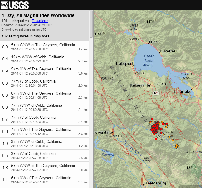
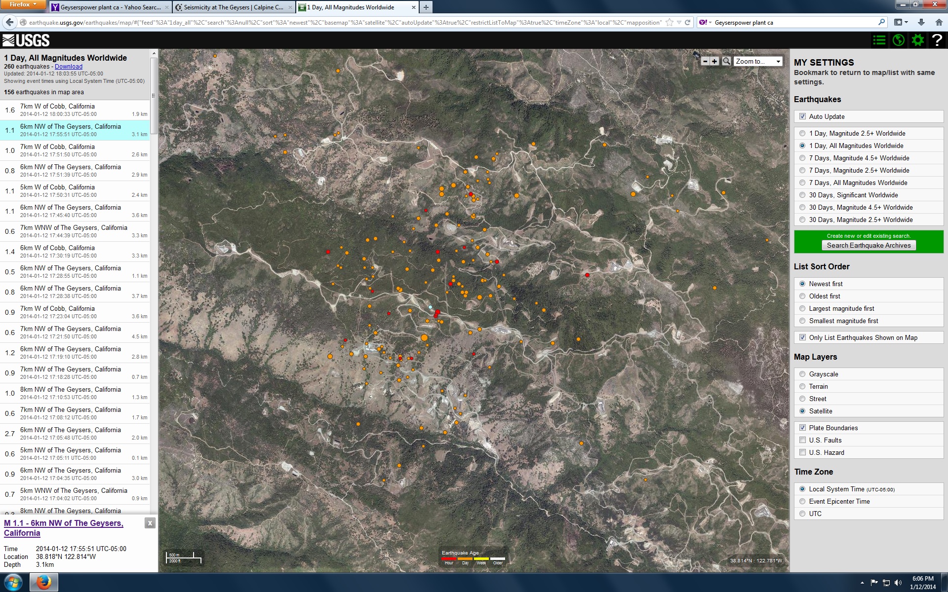
A larger one now with many after shocks comming in around that area.
USGS
A larger one now with many after shocks comming in around that area.
M4.5 - 6km NW of The Geysers, California
2014-01-12 20:24:46 UTC
Event Time
2014-01-12 20:24:46 UTC
2014-01-12 12:24:46 UTC-08:00 at epicenter
2014-01-12 14:24:46 UTC-06:00 system time
Location
38.814°N 122.815°W depth=2.5km (1.6mi)
Nearby Cities
6km (4mi) NW of The Geysers, California
22km (14mi) SW of Clearlake, California
23km (14mi) NNE of Healdsburg, California
29km (18mi) N of Windsor, California
117km (73mi) WNW of Sacramento, California
USGS
Hello Mr. PuterMan. What are we up to in days without a mag 7+? 47 days? 48?
In other news, it looks like The Geysers geothermal area has blown a gasket in the past 30 minutes.
There have been at least 10 more aftershocks since I took this screen grab.
This is the Mag 4.5 that kicked off this sequence. Over 150 people have reportedly felt the mainshock on the DYFI page.
Station NC.GCVB..EHZ
ETA:
I have a question. On the USGS link above for the mag 4.5, it shows a strike-slip focal mechanism, but normal style faulting moment tensor. Are one of these conclusions bad, and since it is early data, subject to revision? Or does that combination signify some special situation I'm just clueless about?
In other news, it looks like The Geysers geothermal area has blown a gasket in the past 30 minutes.
There have been at least 10 more aftershocks since I took this screen grab.
This is the Mag 4.5 that kicked off this sequence. Over 150 people have reportedly felt the mainshock on the DYFI page.
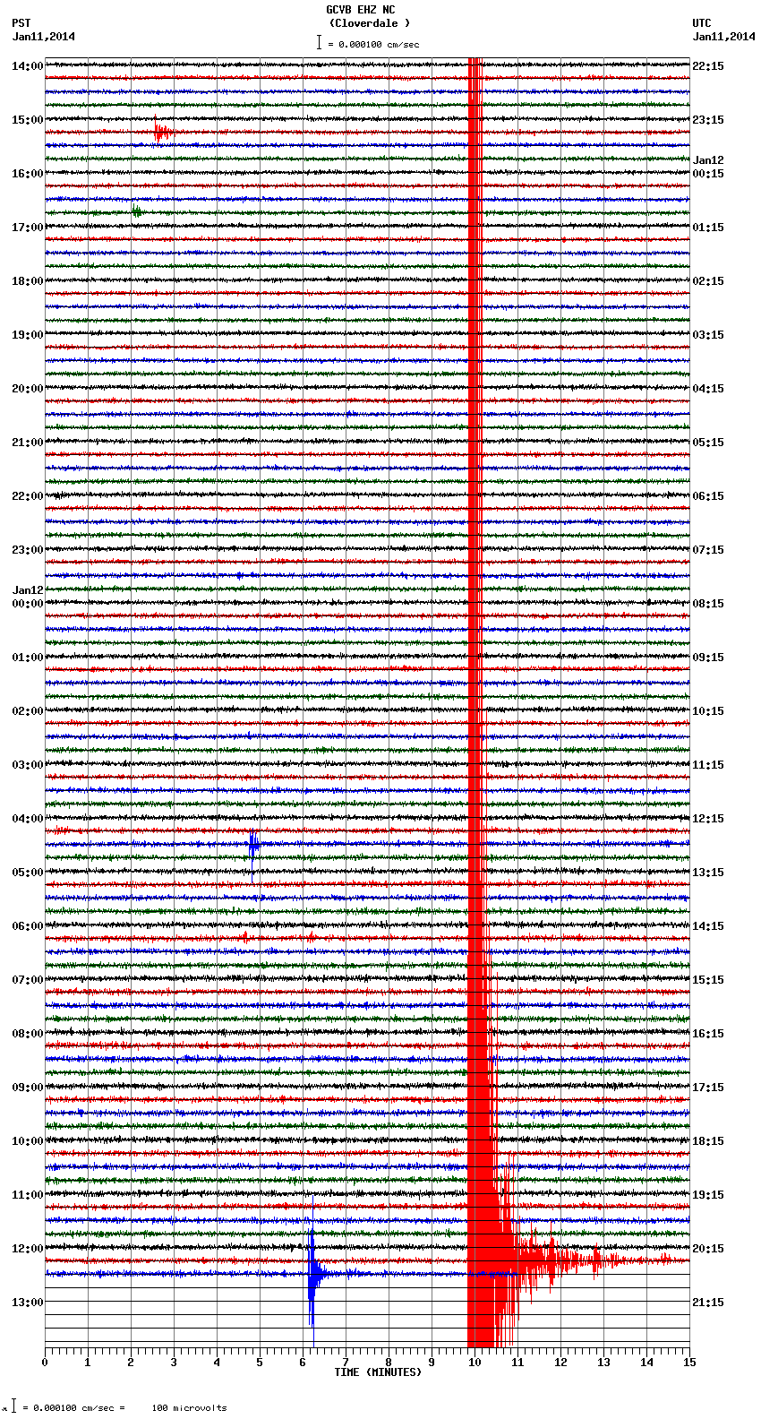
Station NC.GCVB..EHZ
ETA:
I have a question. On the USGS link above for the mag 4.5, it shows a strike-slip focal mechanism, but normal style faulting moment tensor. Are one of these conclusions bad, and since it is early data, subject to revision? Or does that combination signify some special situation I'm just clueless about?
edit on 1/12/2014 by Olivine because: (no reason given)
reply to post by Olivine
Hi!
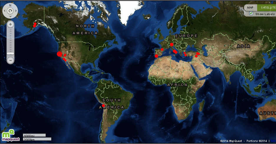
I think that's the most red that I've ever seen in one small area,
in that short of timespan, since I started watching USGS about 4 years ago!
Was it The Salton Sea or Brawley had a good one a while back,
but I don't think it was that many, that close together.
The thing that caught my eye, was the lack of activity in general,
worldwide on the 2.5+ map! It really looks bare!
earthquake.usgs.gov...
WOQ
Hi!
I think that's the most red that I've ever seen in one small area,
in that short of timespan, since I started watching USGS about 4 years ago!
Was it The Salton Sea or Brawley had a good one a while back,
but I don't think it was that many, that close together.
The thing that caught my eye, was the lack of activity in general,
worldwide on the 2.5+ map! It really looks bare!
earthquake.usgs.gov...
WOQ
edit on 12-1-2014 by wasobservingquietly because: (no reason given)
Ive never posted on quake watch before ,but ive followed and trusted this great site for years. I know very little about the science of the quakes ,
but I remember how spot on you all were with the activity of the many small quakes that were humming away before the catastrophy in Japan, Do you
think its abnormal for all the quakes in Northern Ca today is that an ominous sign.
reply to post by overanocean
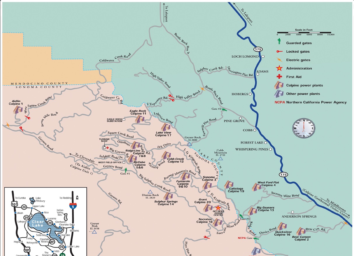
Geysers
Would be nice if they had some sort of condition reporting, think if you live near there?
Maybe it is like a coffee pot peculator when you add too much water. Nice would be just even dry steam.
Seismicity at The Geysers The Geysers is a very seismically active area. Over 99% of seismic events at The Geysers are of magnitude 3.0 or smaller, referred to as “microseismic events” or microearthquakes. Most of these microseismic events are generally not felt by humans unless you happen to be very close by. Calpine exhibit Click to enlarge A network of closely spaced and very sensitive seismometers installed at The Geysers allows detection of micro seismicity down to a very low level. Naturally occurring conditions and small changes in stresses, such as those caused by local changes in reservoir temperature or pressures at depth, can cause small shifts in the rocks resulting in detectable microseismicity. The magnitude, location and depth of microseismic events are used by geoscientists and engineers to study the steam reservoir and its response to steam production and injection. A direct relationship between water injection and microseismicity has been firmly established. However, the relationships of fieldwide steam production and water injection to stronger but less frequent seismic events are more complicated. Importantly, the frequency of seismic events greater than magnitude 3.0 has been trending downward since about 1990. Calpine is continually studying The Geysers’ microseismicity and seeking ways to limit the frequency and reduce the impact of events. The most promising approaches to date involve a more uniform distribution of water injection, including injection rate reductions for particular areas, the addition of many low-rate injectors and relocation of water injection farther away from residential areas.
Geysers
Would be nice if they had some sort of condition reporting, think if you live near there?
edit on 12-1-2014 by donlashway because: (no reason
given)
edit on 12-1-2014 by donlashway because: (no reason given)
edit on 12-1-2014 by donlashway because: (no reason
given)
Maybe it is like a coffee pot peculator when you add too much water. Nice would be just even dry steam.
edit on 12-1-2014 by donlashway
because: (no reason given)
reply to post by donlashway
Thanks for the info , this is a top notch post ,I learn so much from you guys..Sounds like all these little quakes are a different sort of animal all together from the ones on Japans coast before their big one.. Thanks again
Thanks for the info , this is a top notch post ,I learn so much from you guys..Sounds like all these little quakes are a different sort of animal all together from the ones on Japans coast before their big one.. Thanks again
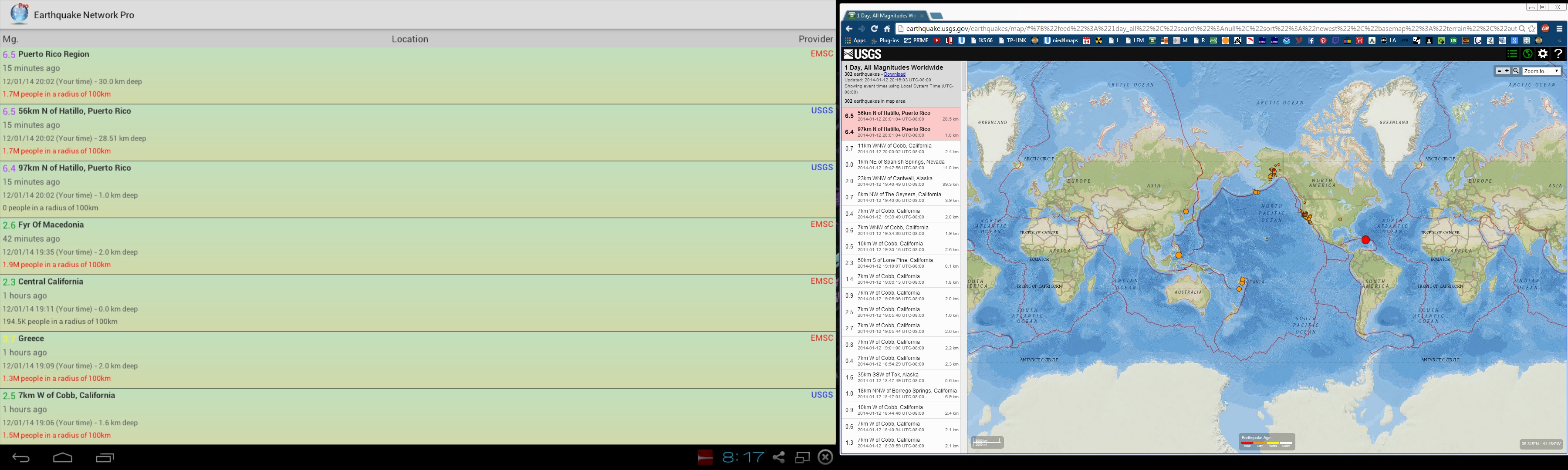
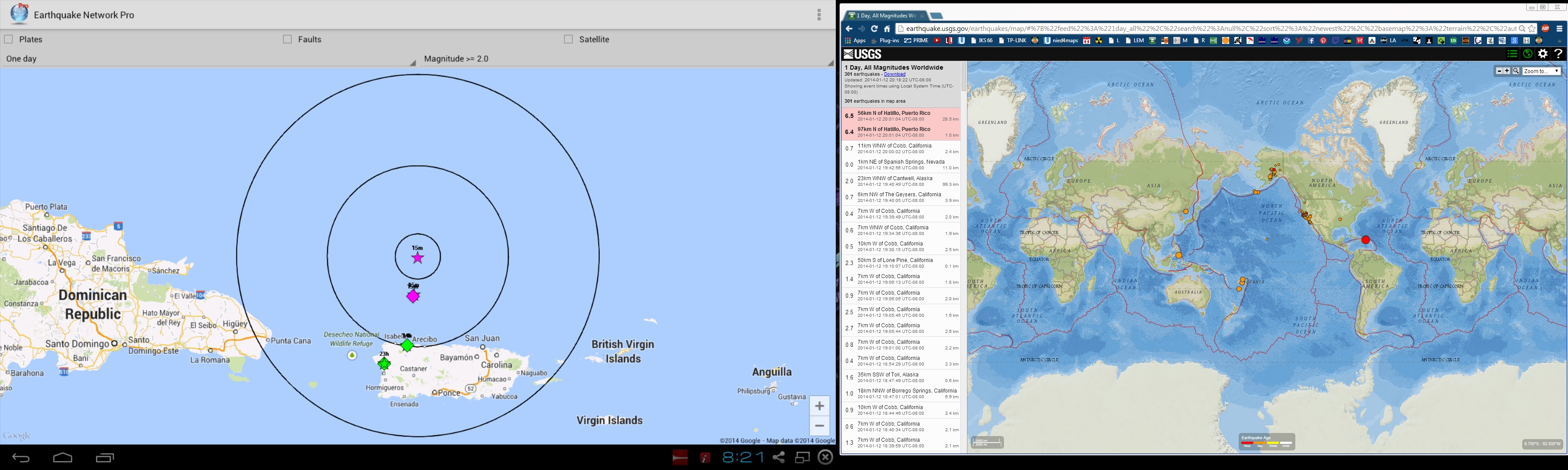
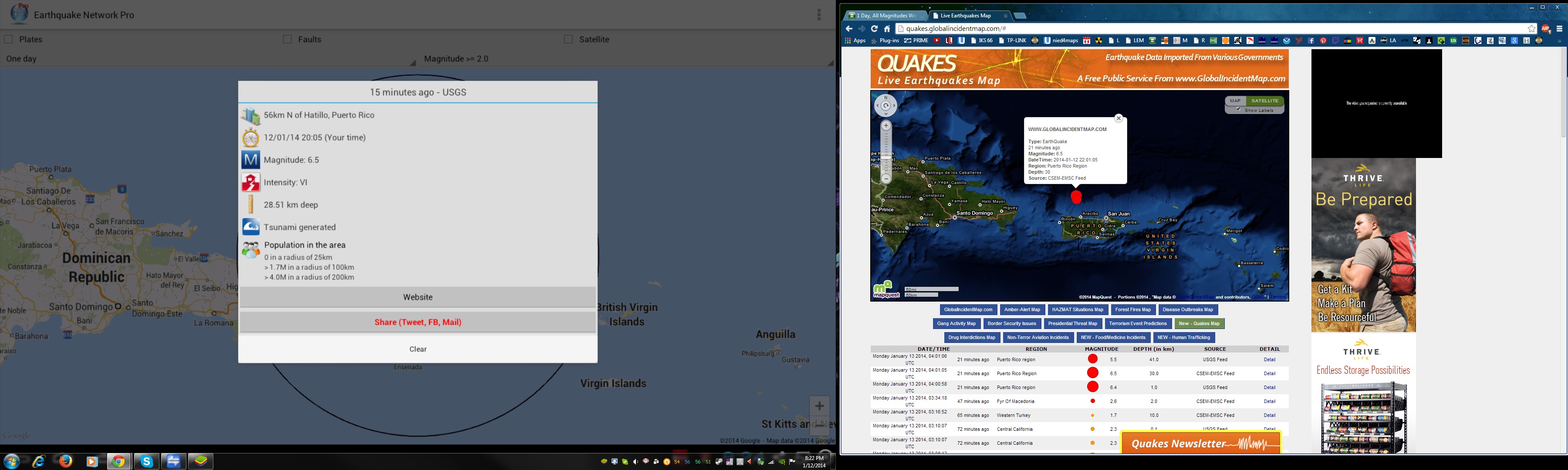
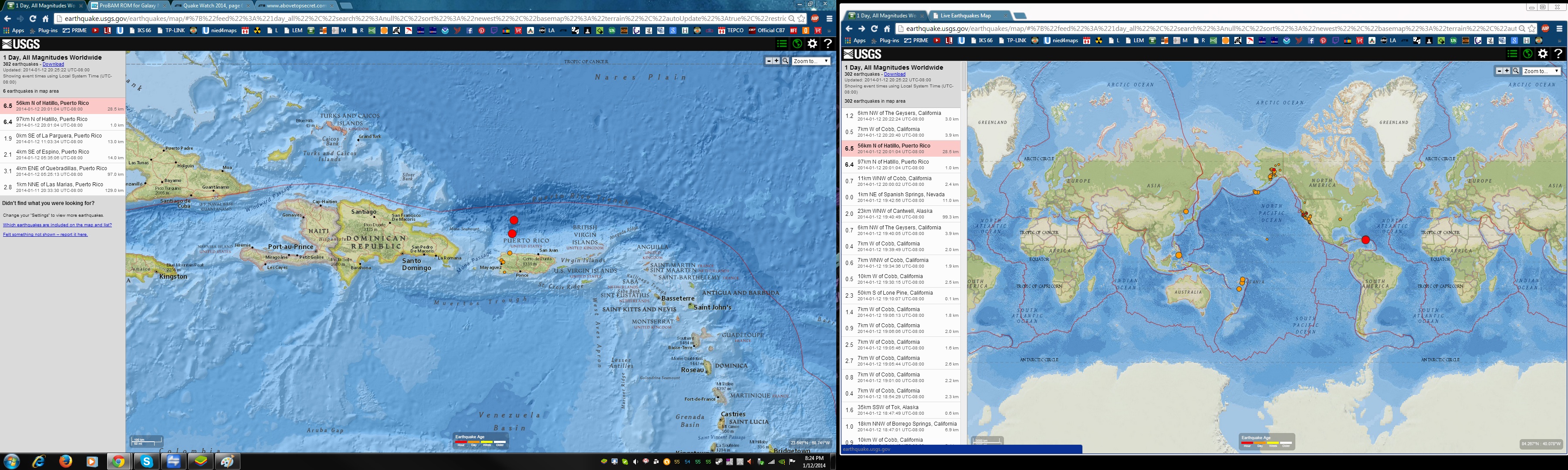
M6.5 - 56km N of Hatillo, Puerto Rico
2014-01-13 04:01:04 UTC
Event Time
2014-01-13 04:01:04 UTC
2014-01-13 00:01:04 UTC-04:00 at epicenter
2014-01-12 22:01:04 UTC-06:00 system time
Location
18.997°N 66.829°W depth=28.5km (17.7mi)
Nearby Cities
56km (35mi) N of Hatillo, Puerto Rico
58km (36mi) NNE of Isabela, Puerto Rico
59km (37mi) NNW of Arecibo, Puerto Rico
67km (42mi) NNW of Barceloneta, Puerto Rico
96km (60mi) NW of San Juan, Puerto Rico
USGS
WECA43 PHEB 130407
TIBCAX
TSUNAMI STATEMENT NUMBER 1
NWS PACIFIC TSUNAMI WARNING CENTER EWA BEACH HI
0407 UTC MON JAN 13 2014
THIS STATEMENT APPLIES TO COUNTRIES WITHIN AND BORDERING THE
CARIBBEAN SEA...EXCEPT FOR PUERTO RICO...THE U.S. VIRGIN
ISLANDS...AND THE U.K. VIRGIN ISLANDS.
... TSUNAMI INFORMATION STATEMENT ...
THIS MESSAGE IS FOR INFORMATION ONLY.
THIS BULLETIN IS ISSUED AS ADVICE TO GOVERNMENT AGENCIES. ONLY
NATIONAL AND LOCAL GOVERNMENT AGENCIES HAVE THE AUTHORITY TO MAKE
DECISIONS REGARDING THE OFFICIAL STATE OF ALERT IN THEIR AREA AND
ANY ACTIONS TO BE TAKEN IN RESPONSE.
AN EARTHQUAKE HAS OCCURRED WITH THESE PRELIMINARY PARAMETERS
ORIGIN TIME - 0401Z 13 JAN 2014
COORDINATES - 19.4 NORTH 66.8 WEST
LOCATION - PUERTO RICO REGION
MAGNITUDE - 6.4
EVALUATION
A DESTRUCTIVE WIDESPREAD TSUNAMI THREAT DOES NOT EXIST BASED ON
HISTORICAL EARTHQUAKE AND TSUNAMI DATA.
HOWEVER - THERE IS THE SMALL POSSIBILITY OF A LOCAL TSUNAMI THAT
COULD AFFECT COASTS LOCATED USUALLY NO MORE THAN A HUNDRED
KILOMETERS FROM THE EARTHQUAKE EPICENTER. AUTHORITIES IN THE
REGION NEAR THE EPICENTER SHOULD BE MADE AWARE OF THIS
POSSIBILITY.
Source
GFZ has 6.3
EMSC 6.5 shows just one
edit on 12-1-2014 by lurksoften because: (no
reason given)
reply to post by lurksoften
DUDE, the Disney/Orlando area seismo on GEE is going nutso right now! I'm a little butthurt we're not feeling anything from it.
Also, aftershock #1:
Edit: What the shiz, USGS just upgraded this aftershock a whole magnitude to a 6.5?? Someone go look & tell me I haven't had 1 beer too many yet & it's correct o.O
Edit 2: wait a second, this looks like a double posting now of the same quake. God, I hope so!
DUDE, the Disney/Orlando area seismo on GEE is going nutso right now! I'm a little butthurt we're not feeling anything from it.
Also, aftershock #1:
M5.5 - 44km N of Hatillo, Puerto Rico 2014-01-13 04:01:06 UTC
Location
18.890°N 66.829°W depth=41.0km (25.5mi)
Edit: What the shiz, USGS just upgraded this aftershock a whole magnitude to a 6.5?? Someone go look & tell me I haven't had 1 beer too many yet & it's correct o.O
edit on 1/12/2014 by Nyiah because: (no reason given)
Edit 2: wait a second, this looks like a double posting now of the same quake. God, I hope so!
edit on 1/12/2014 by Nyiah because: (no reason
given)
Just one 6.5
files.abovetopsecret.com...
files.abovetopsecret.com...
files.abovetopsecret.com...
files.abovetopsecret.com...
files.abovetopsecret.com...
files.abovetopsecret.com...
files.abovetopsecret.com...
files.abovetopsecret.com...
edit on 7/30/2012 by dreamfox1 because: (Was one 6.5)
edit on
7/30/2012 by dreamfox1 because: Just one 6.5
edit on 7/30/2012 by dreamfox1 because: (no reason given)
reply to post by Nyiah
Well, USGS says this, at the moment
6.5
56km N of Hatillo, Puerto Rico
2014-01-12 22:01:04 UTC-06:00 28.5 km
6.4
97km N of Hatillo, Puerto Rico
2014-01-12 22:01:04 UTC-06:00 1.0 km
Exact same time tho, hmm
ETA:
WTH??? Now not two, not one, but nada, gone, poof.
ETA again, I swear they were gone, now they are back
6.5
56km N of Hatillo, Puerto Rico
2014-01-12 22:01:04 UTC-06:00 28.5 km
6.4
97km N of Hatillo, Puerto Rico
2014-01-12 22:01:04 UTC-06:00 1.0 km
I think I will go back to bed now
Well, USGS says this, at the moment
6.5
56km N of Hatillo, Puerto Rico
2014-01-12 22:01:04 UTC-06:00 28.5 km
6.4
97km N of Hatillo, Puerto Rico
2014-01-12 22:01:04 UTC-06:00 1.0 km
Exact same time tho, hmm
ETA:
WTH??? Now not two, not one, but nada, gone, poof.
edit on 12-1-2014 by berkeleygal because: (no reason given)
ETA again, I swear they were gone, now they are back
6.5
56km N of Hatillo, Puerto Rico
2014-01-12 22:01:04 UTC-06:00 28.5 km
6.4
97km N of Hatillo, Puerto Rico
2014-01-12 22:01:04 UTC-06:00 1.0 km
I think I will go back to bed now
edit on 12-1-2014 by berkeleygal because: (no reason given)
reply to post by berkeleygal
Yeah, I know, I realized it may be a double posting when the time between it and lurksoften's post suddenly became the sae time for both:
LO's:
And I see they dropped the double now, too. I'm off to see if I can get the new GEE to not crash when I add another station, want to watch the PR area now.
Edit: Damn, no data available for the San Juan station. Rats.
Yeah, I know, I realized it may be a double posting when the time between it and lurksoften's post suddenly became the sae time for both:
LO's:
M6.4 - 97km N of Hatillo, Puerto Rico
2014-01-13 04:00:58 UTC
And I see they dropped the double now, too. I'm off to see if I can get the new GEE to not crash when I add another station, want to watch the PR area now.
edit on 1/12/2014 by Nyiah because: (no reason given)
Edit: Damn, no data available for the San Juan station. Rats.
edit on 1/12/2014 by Nyiah because: (no reason given)
I find it a little strange that since this quake, there's been no aftershocks reported yet, or even other small quakes in the area as per
normal. The San Juan station in GEE isn't operating at the moment, and I've been googling up a storm, but I can't locate any live or near-real time
seismos for the island online (I feel like I'm fumbling in the dark, to be honest) If anyone knows a link for the area that I can keep my eye on,
please post it?
Edit: I feel like an idiot, I found this one:
www.prsn.uprm.edu...
I can't see any web plots, though, the pages are just blank no matter which station I choose.
Edit: I feel like an idiot, I found this one:
www.prsn.uprm.edu...
I can't see any web plots, though, the pages are just blank no matter which station I choose.
edit on 1/12/2014 by Nyiah because: (no reason
given)
reply to post by Nyiah
There have been at least ten aftershocks, but small, like in the 2.5 to 3.2 range. Problem is, that with those dynamic webicorders, the 6.5 dwarfs them into apparent nonexistence. But they are there, and the fault is still fidgeting. Add network PR in GEE, and pull up stations AGPR, AOPR, and EMPR. That ought to do ya.
IMHO, they will revise that quake upwards in time to about 6.8 to 7. It clipped just about every station within 200 km, so, like in Japan when the 9+ hit- initially it was difficult to get a read on it. I mean come on, that look like a measily 6.5 to you? :
www.iris.edu...
That looks more like a 7 or so to me. The IU.San Juan station has been out for a while now. And too bad, cause it might have had the headroom to handle that quake, for a better read on it. Situations like this where the area has potential for big quakes, and yet are covered by seismometers that can't really handle them cleanly without clipping, present potential public hazards. It could cause scientists like at the PTWC to underestimate the size of a quake, and claim no tsunami threat- when really- there's a 20 foot wall of water on the way. And for the first ten minutes or so after the Japan 9+, that's exactly what happened. Too big. Did that actually cost lives? God knows- if there is one.
edit on Mon Jan 13th 2014 by
TrueAmerican because: (no reason given)
TrueAmerican
reply to post by Nyiah
There have been at least ten aftershocks, but small, like in the 2.5 to 3.2 range. Problem is, that with those dynamic webicorders, the 6.5 dwarfs them into apparent nonexistence. But they are there, and the fault is still fidgeting. Add network PR in GEE, and pull up stations AGPR, AOPR, and EMPR. That ought to do ya.
Thanks, I keep forgetting about that part of GEE I tried to add the PR network, but nothing loaded into the station chooser list, no changes on the map. I closed down & rebooted even, same result after getting it running again. If you're able to see them, I've no idea what the problem is on my end. Ideas?? I'm baffled (unless the issue is on their end or with GEE)
Edit: About the webicorder--Yeah, that does look awfully large, doesn't it? USGS refigured it down to a 6.4 though, are you still expecting it to be adjusted again regardless?
edit on 1/13/2014 by Nyiah because: (no reason given)
new topics
-
Who guards the guards
US Political Madness: 2 hours ago -
Has Tesla manipulated data logs to cover up auto pilot crash?
Automotive Discussion: 4 hours ago -
whistleblower Captain Bill Uhouse on the Kingman UFO recovery
Aliens and UFOs: 9 hours ago -
1980s Arcade
General Chit Chat: 11 hours ago -
Deadpool and Wolverine
Movies: 11 hours ago
top topics
-
Lawsuit Seeks to ‘Ban the Jab’ in Florida
Diseases and Pandemics: 16 hours ago, 20 flags -
whistleblower Captain Bill Uhouse on the Kingman UFO recovery
Aliens and UFOs: 9 hours ago, 9 flags -
CIA botched its handling of sexual assault allegations, House intel report says
Breaking Alternative News: 14 hours ago, 8 flags -
Deadpool and Wolverine
Movies: 11 hours ago, 4 flags -
1980s Arcade
General Chit Chat: 11 hours ago, 4 flags -
Teenager makes chess history becoming the youngest challenger for the world championship crown
Other Current Events: 13 hours ago, 3 flags -
Who guards the guards
US Political Madness: 2 hours ago, 1 flags -
Has Tesla manipulated data logs to cover up auto pilot crash?
Automotive Discussion: 4 hours ago, 0 flags
active topics
-
"We're All Hamas" Heard at Columbia University Protests
Social Issues and Civil Unrest • 208 • : FlyersFan -
Mood Music Part VI
Music • 3088 • : TheWoker -
whistleblower Captain Bill Uhouse on the Kingman UFO recovery
Aliens and UFOs • 9 • : Ophiuchus1 -
The Democrats Take Control the House - Look what happened while you were sleeping
US Political Madness • 107 • : watchitburn -
They Killed Dr. Who for Good
Rant • 65 • : grey580 -
House Overwhelmingly Passes Funding for Ukraine, Israel and Taiwan
US Political Madness • 60 • : Justoneman -
Candidate TRUMP Now Has Crazy Judge JUAN MERCHAN After Him - The Stormy Daniels Hush-Money Case.
Political Conspiracies • 628 • : FlyersFan -
I Guess Cloud Seeding Works
Fragile Earth • 38 • : seekshelter -
Another person lights themselves on fire and dies on College campus, happened in Red Deer, Canada
Mainstream News • 28 • : seekshelter -
23,000 Dead People Registered Within a Two Week Period In One State
US Political Madness • 41 • : Xtrozero