It looks like you're using an Ad Blocker.
Please white-list or disable AboveTopSecret.com in your ad-blocking tool.
Thank you.
Some features of ATS will be disabled while you continue to use an ad-blocker.

Quake Watch 2014
page: 43share:
hmm still nothing from puterman or muzzy about the 7.6 aftershock? where are they
aLLeKs
hmm still nothing from puterman or muzzy about the 7.6 aftershock? where are they
I know, right?
Magnitude 6.0
Region SOLOMON ISLANDS
Date time 2014-04-04 11:40:34.0 UTC
Location 10.50 S ; 161.60 E
Depth 74 km
The seismic region is this:
www.mapsism.com...
Region SOLOMON ISLANDS
Date time 2014-04-04 11:40:34.0 UTC
Location 10.50 S ; 161.60 E
Depth 74 km
The seismic region is this:
www.mapsism.com...
reply to post by Rodrigoson6
I should just point out to you that these maps you keep linking to do NOT give correct seismic region numbers.
That map is saying region 146 whereas the seismic region of the Solomon Islands is 193 using the accepted Flinn-Engdahl seismic regions that are in common use throughout seismology. Region 146 is Southern Argentina which is a part of seismic area 9 - Extreme South America.
I have no idea who this person is who owns the copyright of the material on the site - thus is the site owner - but if purporting to be a serious site about seismology should at least be capable of using the Flinn-Engdahl regions as a basis for the divisions, as Muzzy and myself did when we carved up New Zealand into sightly different bands.
reply to post by aLLeKs
It is an aftershock! Well it might be. I have not had time to look into to yet and it falls outside the normal parameters for aftershocks so it may be an event in it's own right.
(actually I lost everything for 24 hours - could not get into the computer and am only just bringing everything back on line again)
I note Solomon - getting close to Santa Cruz/Vanuatu even though different seismic regions.
edit on 4/4/2014 by PuterMan because: (no reason given)
PuterMan
I note Solomon - getting close to Santa Cruz/Vanuatu even though different seismic regions.
i thought of you when I saw that quake. *bows to PM's seismic genius*
Down a different avenue, I noticed this oddly shallow earthquake, from the wee hours this morning. Mag 3.5 Utah
At a depth of -2.5 kms?
Here is the Google map location. I noticed this strange, industrial facility about 4 kms distant.
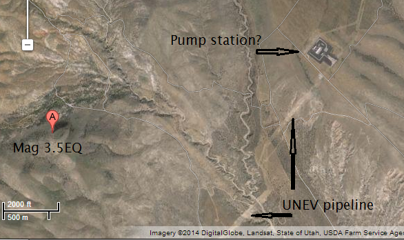
I'm guessing it is a pumping station for the Unev petroleum product pipeline, that runs between Las Vegas and near Salt Lake City. Here is a link to a BLM .pdf map of the pipeline route.s
So, mag 3.5 isn't a large earthquake--but it would be a very large explosion.
I wonder if there is a connection? A landslide? (the seismic signal looks earthquakey to me) Or just an earthquake with a bad depth given? (the elevation at the epicenter is 4880', or 1.487 kms)
edit on 4/4/2014 by
Olivine because: forgot an "n"
edit on 4/4/2014 by Olivine because: (no reason given)
Chile
sorry been busy, there is rain coming, got to do some work.
I managed to get the time to do the usual maps for GSAIM
here is Chile for 03.04.2014 showing the 7.6 aftershock and others
goo.gl...
and 04.04.2014 up to 15:21:01UTC
goo.gl...
edit: activity seems to be spreading South
also confirming;
F-E Region: Solomon Islands
Time: 2014-04-04 11:40:34.3 UTC
Magnitude: 6.0 (Mw)
Epicenter: 161.54°E 10.46°S
Depth: 72 km
Status: M - manually revised
geofon.gfz-potsdam.de...
Guadacanal, Solomons being hit by torrential rains, people have drowned, Honiara a right off, looks like developing into a Cyclone in all but name
got to go, good luck out there
edit on 04u939314 by muzzy because: (no reason given)
Magnitude ML 5.4 Region SOUTHERN GREECE Date time 2014-04-04 20:08:08.0 UTC Location 37.18 N ; 23.72 E Depth 10 km Distances 89 km S of Athens, Greece / pop: 729,137 / local time: 23:08:08.0 2014-04-04 29 km SE of Ýdra, Greece / pop: 2,526 / local time: 23:08:08.0 2014-04-04
emsc
Felt that one here on Crete Island
opal13
reply to post by TDawgRex
I have no idea. You can see the quakes, but the needle has just been quivering for what would be hours if the roll is set up at one revolution per 30 minutes.
Harmonic tremors?
More likely interference from other sources of ground vibration such as wind and vehicles. Looked at it just now, and there is interference - it 1:21 pm in Los Angeles.
URGENT
Got a friend in Moldova chatting online...says she's having an EQ....she's in Moldova....anyone?
Got a friend in Moldova chatting online...says she's having an EQ....she's in Moldova....anyone?
reply to post by angelchemuel
couple in Poland,,might have travelled down range of mountain spine,, into Moldavia,, but its literally and figurativly,,quite a stretch.
ohh nothing,, in Moldavia.
yet?
couple in Poland,,might have travelled down range of mountain spine,, into Moldavia,, but its literally and figurativly,,quite a stretch.
ohh nothing,, in Moldavia.
yet?
reply to post by BobAthome
Thanks Bob....
Isn't there a difference between Moldova (bordering Romania) and Moldavia?
Rainbow
Jane
PS must have been a tidler....she carried on with the online quiz
Thanks Bob....
Isn't there a difference between Moldova (bordering Romania) and Moldavia?
Rainbow
Jane
PS must have been a tidler....she carried on with the online quiz
edit on 4-4-2014 by angelchemuel because: (no reason given)
reply to post by angelchemuel
"Moldova nians??? / "Moldova ers???,, u most certainly correct.
as u me duh!
"Moldova nians??? / "Moldova ers???,, u most certainly correct.
as u me duh!
reply to post by BobAthome
I know I've had a Friday night drink...but even that didn't make sense to me!
Nice to bump into you again btw!
Rainbows
Jane
I know I've had a Friday night drink...but even that didn't make sense to me!
Nice to bump into you again btw!
Rainbows
Jane
reply to post by angelchemuel
"Isn't there a difference between Moldova (bordering Romania) and Moldavia? "
yes correct .
and i assumed that the reference would be missed.
i ass um duh
i as u me duh
sorry
yes bumped ,,ouch,,, yes it is
"Isn't there a difference between Moldova (bordering Romania) and Moldavia? "
yes correct .
and i assumed that the reference would be missed.
i ass um duh
i as u me duh
sorry
yes bumped ,,ouch,,, yes it is
edit on 4/4/2014 by BobAthome because: (no reason given)
reply to post by BobAthome
Well she's still asking questions...so it couldn't have been too bad!
I'm skipping the chemistry and periodic table questions!
Rainbows
Jane
Well she's still asking questions...so it couldn't have been too bad!
I'm skipping the chemistry and periodic table questions!
Rainbows
Jane
reply to post by PuterMan
My system is 'different from the Flinn-Engdahl.
Flinn-Engdahl have divided the globe into a more regions. I in 249 regions, and this subdivision 'was made with different criteria and for different purposes.
also my subdivision and 'for a less experienced audience. When you open the page, each user can 'read' cause earthquakes occur in that area. Can 'understand the tectonic plates which are present in the area.
It has no ties with the regions of Flinn-Engdahl. ok?
Rodrigoson6
reply to post by PuterMan
My system is 'different from the Flinn-Engdahl.
Flinn-Engdahl have divided the globe into a more regions. I in 249 regions, and this subdivision 'was made with different criteria and for different purposes.
also my subdivision and 'for a less experienced audience. When you open the page, each user can 'read' cause earthquakes occur in that area. Can 'understand the tectonic plates which are present in the area.
It has no ties with the regions of Flinn-Engdahl. ok?
Well ..... no, not OK!
Having everyone on the planet use one system is really good, we all understand it.
To give an example to make the point. What if you divided a compass into 100 degrees because it would be easier and it would be 'metric.'
Sounds OK except the rest of the world is using 360 degrees. It would get confusing as all hell, planes would crash, ships would get beached and hikers would ave a world of hurt.
Why not use the same system as the rest of the world? The system you are using only serves to confuse and prevent understanding and communication.
P
reply to post by Rodrigoson6
What you are doing with the description and details and links inside the map rectangles is all fine, good job, but you really need to match them with what has already been accepted Globally by the scientific community and general public.
Long term, Puterman and I are building a Google Earth file of all the F_E Regions, Japan has been done, and New Zealand, I think he was working on the South West Pacific last time we talked about it.
You would be better off working on that along with us, No?
I have a clue as to why this has not been done yet (KML files of F_E Regions), its a monster job, could take a lifetime! or two!!
new topics
-
Hate makes for strange bedfellows
US Political Madness: 1 hours ago -
Who guards the guards
US Political Madness: 4 hours ago -
Has Tesla manipulated data logs to cover up auto pilot crash?
Automotive Discussion: 6 hours ago -
whistleblower Captain Bill Uhouse on the Kingman UFO recovery
Aliens and UFOs: 11 hours ago
top topics
-
CIA botched its handling of sexual assault allegations, House intel report says
Breaking Alternative News: 16 hours ago, 11 flags -
whistleblower Captain Bill Uhouse on the Kingman UFO recovery
Aliens and UFOs: 11 hours ago, 10 flags -
Who guards the guards
US Political Madness: 4 hours ago, 8 flags -
Hate makes for strange bedfellows
US Political Madness: 1 hours ago, 6 flags -
1980s Arcade
General Chit Chat: 13 hours ago, 5 flags -
Teenager makes chess history becoming the youngest challenger for the world championship crown
Other Current Events: 15 hours ago, 4 flags -
Deadpool and Wolverine
Movies: 14 hours ago, 4 flags -
Has Tesla manipulated data logs to cover up auto pilot crash?
Automotive Discussion: 6 hours ago, 2 flags
active topics
-
Candidate TRUMP Now Has Crazy Judge JUAN MERCHAN After Him - The Stormy Daniels Hush-Money Case.
Political Conspiracies • 675 • : Vermilion -
"We're All Hamas" Heard at Columbia University Protests
Social Issues and Civil Unrest • 230 • : network dude -
1980s Arcade
General Chit Chat • 14 • : ATruGod -
MULTIPLE SKYMASTER MESSAGES GOING OUT
World War Three • 94 • : Irishhaf -
Teenager makes chess history becoming the youngest challenger for the world championship crown
Other Current Events • 4 • : Consvoli -
Fast Moving Disc Shaped UFO Captured on Camera During Flight from Florida to New York City
Aliens and UFOs • 19 • : xWorldxGonexMadx -
British TV Presenter Refuses To Use Guest's Preferred Pronouns
Education and Media • 112 • : Annee -
IDF Intel Chief Resigns Over Hamas attack
Middle East Issues • 40 • : FlyersFan -
Strange Humanoid-Shaped Object Captured On Film In The Skies Over California
Aliens and UFOs • 23 • : Consvoli -
whistleblower Captain Bill Uhouse on the Kingman UFO recovery
Aliens and UFOs • 13 • : 38181