It looks like you're using an Ad Blocker.
Please white-list or disable AboveTopSecret.com in your ad-blocking tool.
Thank you.
Some features of ATS will be disabled while you continue to use an ad-blocker.

Quake Watch 2014
page: 33share:
reply to post by Rodrigoson6
Hey Rodrigoson6 did you make thos seismic maps?
If so New Zealand is wrong those don't match up with the Flinn-Engdahl (F_E) seismic and geographical regionalization scheme at all.
You might want to peruse this NZ sub region layout that Puterman and I created, its based on geology, not provinces.
G_L Regions
offshore Tarapaca aftershocks seem to be North of the Mainshock and the other M6Mw's now ???
gsaim.wordpress.com... At the 6 day mark they were trending SE.
I have decided to keep an eye on the area daily, as well as update the T'pcaEQArchives page when I can.
Kefalonia, Greece series is still going, but I haven't grabbed the data for a few days.
Where else?? I need another 2 areas to make a 2nd row.
Must have at least 20 quakes per day, every day, to make it worthwhile
I don't know if I mentioned it here, the aftershock maps in this series have a new muzzy feature, "ghost" icons, these are the bigger quakes M5.7+. They show on each map, for reference as to where the aftershocks are trending.
edit on 03u868614 by muzzy because: clarification
I have little understanding of seismic zones, thrust plates, and all of the other things talked about on here, so please forgive me if this is a
preposterous question. ( I feel like a kindergartener in a high school class...lol! )
If erosion were to occur allowing a large amount of water to seep into a major fault, would it have the effect of 'lubricating' the plates/fault line?
Thanks,
Ms.Nugget
If erosion were to occur allowing a large amount of water to seep into a major fault, would it have the effect of 'lubricating' the plates/fault line?
Thanks,
Ms.Nugget
muzzy
reply to post by Rodrigoson6
Hey Rodrigoson6 did you make thos seismic maps?
If so New Zealand is wrong those don't match up with the Flinn-Engdahl (F_E) seismic and geographical regionalization scheme at all.
You might want to peruse this NZ sub region layout that Puterman and I created, its based on geology, not provinces.
G_L Regions
Hey
No my maps are make in another way..
Are more "easy"...
www.mapsism.com...
in that map the are 249 seismic regions of the world. And if you clik on the region, it will open a page where you can read and to know the description of region.
For example: plate tectionics, the depht of region's quakes, faults ecc ecc.
I thought the last big earthquake was an 8M in the Scotia Sea back in November. But it was 7.8M. Other than that one, we haven't had much in the 7
point range. Recently, we've had enough 6's close to 7, but no cigar. Mainly along the Americas. I wouldn't say it's quiet. It's just slow and steady
wins the race. I was watching that webcam where you can see paint flaking off with my son to bore him. Sometimes watching earthquakes is like watching
a car crash in super slo-mo. You have to think of the last months and years as part of the same action. This way, you roll the tape back and forth and
you see the whole thing. If you stare at the tree you miss the forest. And, bigfoot. To my mind's eye, something is making its way under South
America. As it pushes under, it pushes the whole spine. The Chile earthquakes are interesting because there doesn't appear to be a main shock. Rather,
it may seem to be a consistent movement. Not a quiet slow-slip. Just a slip that's slow. And not sudden. I think this is a good thing for Chile. (at
the moment). Because the energy be released one way or another. Maybe this way, you don't get a big bump followed by lots of little ones. Instead,
it's like an old steam locomotive going uphill, chugachuga.
choo
choo
here was just a little wiggle and I checked. It was Nicaragua. Central America has been consistent.
earthquake.usgs.gov...
Over the last few months, South America had been quiet. And, I'm talking marginally quiet. But, now it seems to be chiming in on a more regular basis. Many of the earthquakes are inland. Of course I am ignoring the earthquakes off Chile and Peru. These are focus because they lay at the bend in the spine.
choo
choo
here was just a little wiggle and I checked. It was Nicaragua. Central America has been consistent.
earthquake.usgs.gov...
Over the last few months, South America had been quiet. And, I'm talking marginally quiet. But, now it seems to be chiming in on a more regular basis. Many of the earthquakes are inland. Of course I am ignoring the earthquakes off Chile and Peru. These are focus because they lay at the bend in the spine.
edit on 28-3-2014 by ericblair4891 because: (no reason given)
reply to post by ericblair4891
I agree that this series off Chile has some high magnitudes, but there IS a Mainshock, a 6.7Mw
following that there has been a 5.9ML and a 5.7ML and a 5.8ML and a 6.1ML
conversion to Mw by the big networks just makes it looks worse than it really is, as above 5.8 they turn to 6's.
I don't see this turning into a M8.
I can assure you anything over 6.3ML is BIG, those are not rattlers, they make it seem like the whole planet is wobbling.
edit on 03u868614 by muzzy because: (no reason given)
reply to post by nugget1
The only problem with that theory is that if this was true then places where there was heavy rainfall would have more quakes than other places.
Also take into consideration a lot of earthquakes occur in mountainous regions, earthquakes produce mountains (over millions of years)
Erosion is just part of the breakdown of the mountains.
Your theory has been discussed in the scientific community for years, but I have never seen any compelling results to prove it one way or the other.
muzzy
reply to post by nugget1
The only problem with that theory is that if this was true then places where there was heavy rainfall would have more quakes than other places.
Also take into consideration a lot of earthquakes occur in mountainous regions, earthquakes produce mountains (over millions of years)
Erosion is just part of the breakdown of the mountains.
Your theory has been discussed in the scientific community for years, but I have never seen any compelling results to prove it one way or the other.
Thanks, Muzzy. It isn't any kind of theory on my part, just my mind wandering. I was thinking how the severe drought in Cali followed by heavy rains might cause things to move....then I began thinking about the gulf, and the sink holes, then the NMSZ....and I have zero knowledge of how this stuff works.
I appreciate your reply.
Ms.Nugget
reply to post by muzzy
Yes... but i call the seismic area with the name "Region", but the system of "my" regions is another thing..
Ok??
If yuo see here
www.mapsism.com...
The red rectangle is a region (or "seismic area")
If you click on a region it will open a page where there is a description about clicked region
the description is importat for the "middle-user" no expert
Bye
Yep and shallow, bet they felt that
wheres that TV station Live siesmograph at?
edit: ah here we are abclocal.go.com...
edit 2: cool, first time I've ever seen the needle move
any injuries?
wheres that TV station Live siesmograph at?
edit: ah here we are abclocal.go.com...
edit on 03u878714 by muzzy because: (no reason given)
edit 2: cool, first time I've ever seen the needle move
edit on 03u878714 by muzzy because: (no reason given)
any injuries?
edit on 03u878714 by muzzy because: (no reason given)
Well over a dozen fore/aftershocks.
I'm almost 40 miles from the epicenter(s) and have only felt the largest / 5.1.
I'm almost 40 miles from the epicenter(s) and have only felt the largest / 5.1.
reply to post by abecedarian
this the page to watch the list?
www.data.scec.org...
42 aftershocks in the first 2 hrs
this the page to watch the list?
www.data.scec.org...
42 aftershocks in the first 2 hrs
edit on 03000000878714 by muzzy because: (no reason given)
Could The Geysers, CA be tied into the 5.1 quake? I looked at the list of recent activity and it seems to be pretty active? Are they connected
somehow though The Geysers is a little north of San Fran?
edit on 3/29/2014 by seentoomuch because: (no reason given)
Seems too far to be connected to me.
seentoomuch
Could The Geysers, CA be tied into the 5.1 quake? I looked at the list of recent activity and it seems to be pretty active? Are they connected somehow though The Geysers is a little north of San Fran?
Something is going on in LaHabra though. I've felt 8 earthquakes in 8 hours and I'm not even in La Habra.
Out of the 54 earthquakes in the last 24 hours, a lot have been in LaHabra as seen here:
earthquake.usgs.gov...
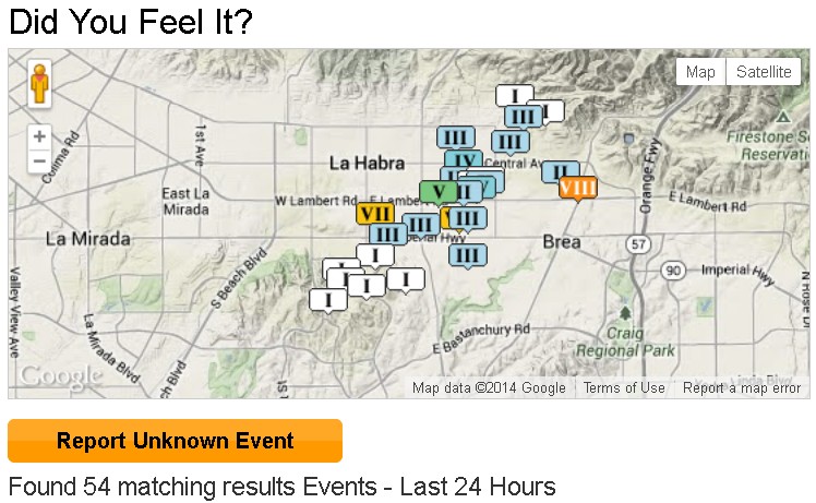
That link is constantly updating so if you click it 24 hours later it will show completely different earthquakes in the previous 24 hours. That's why I screencapped the map activity to show what's been happening in LaHabra.
One of my neighbors had a bottle of Tabasco sauce break on the kitchen floor so their kitchen reeks of hot sauce. I'm lucky nothing broke but some cans got dented when they fell on the kitchen floor.
edit on 29-3-2014 by Arbitrageur because: clarification
this is the seismic region of Los angeles:
www.mapsism.com...
I think that the quake occured in the South part of sant'andreas fault.
www.mapsism.com...
I think that the quake occured in the South part of sant'andreas fault.
I haven't seen too much activity on the San Andreas Fault. If you mean the LaHabra quakes, according to this link they think it could be related to the Puente Hills Thrust
Rodrigoson6
this is the seismic region of Los angeles:
www.mapsism.com...
I think that the quake occured in the South part of sant'andreas fault.
earthquake.usgs.gov...
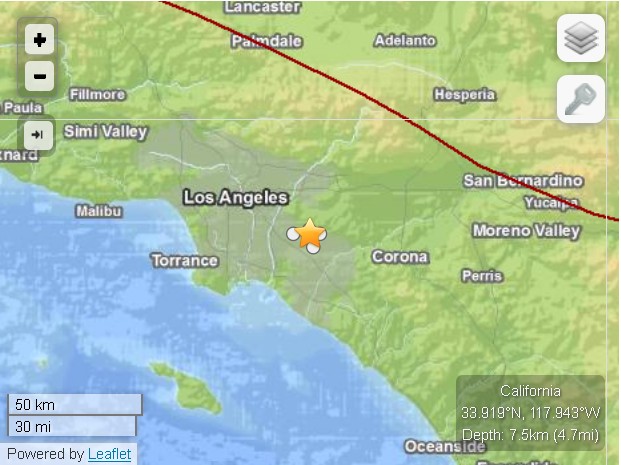
The star is where the series of LaHabra Earthquakes happened and the red line to the upper right is San Andreas fault, so not related.
This sequence could be associated with the Puente Hills thrust (PHT). The PHT is a blind thrust fault that extends from this region to the north and west towards the City of Los Angeles. It caused the M5.9 1987 Oct. 1 Whittier Narrows earthquake.
Previously, the M5.4 2008 Chino Hills earthquake occurred in this region. It caused somewhat stronger shaking in Orange County and across the Los Angeles Basin.
The moment tensor shows oblique faulting, with a north dipping plane that approximately aligns with the Puente Hills thrust.
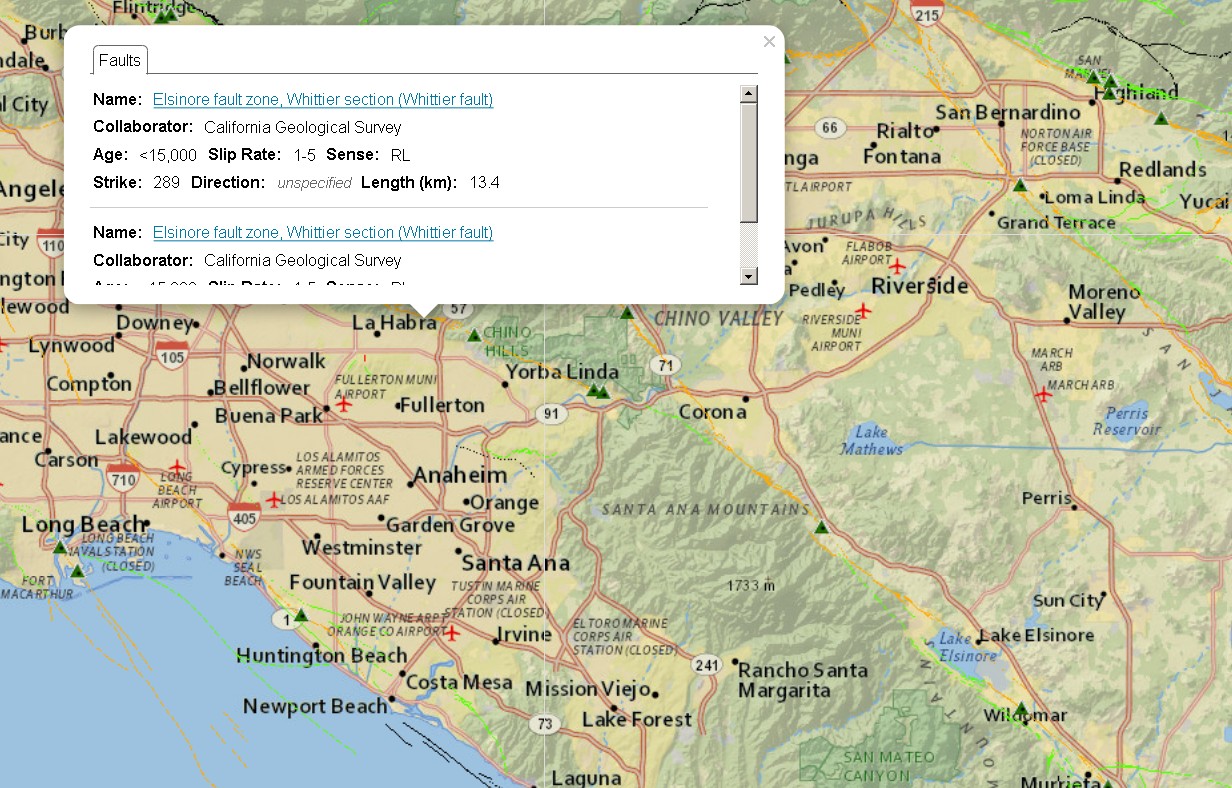
There's no fault shown on the fault map here in the exact location of the quakes. The closest fault shown is the Elsinore fault zone:
earthquake.usgs.gov...
reply to post by Arbitrageur
no faults but they are fracking and injection wells within a few miles of the quakes pic posted in stop fracking california on fb
no faults but they are fracking and injection wells within a few miles of the quakes pic posted in stop fracking california on fb
new topics
-
Las Vegas UFO Spotting Teen Traumatized by Demon Creature in Backyard
Aliens and UFOs: 1 hours ago -
2024 Pigeon Forge Rod Run - On the Strip (Video made for you)
Automotive Discussion: 2 hours ago -
Gaza Terrorists Attack US Humanitarian Pier During Construction
Middle East Issues: 2 hours ago -
The functionality of boldening and italics is clunky and no post char limit warning?
ATS Freshman's Forum: 4 hours ago -
Meadows, Giuliani Among 11 Indicted in Arizona in Latest 2020 Election Subversion Case
Mainstream News: 4 hours ago -
Massachusetts Drag Queen Leads Young Kids in Free Palestine Chant
Social Issues and Civil Unrest: 4 hours ago -
Weinstein's conviction overturned
Mainstream News: 6 hours ago -
Supreme Court Oral Arguments 4.25.2024 - Are PRESIDENTS IMMUNE From Later Being Prosecuted.
Above Politics: 7 hours ago -
Krystalnacht on today's most elite Universities?
Social Issues and Civil Unrest: 7 hours ago -
Chris Christie Wishes Death Upon Trump and Ramaswamy
Politicians & People: 8 hours ago
top topics
-
Krystalnacht on today's most elite Universities?
Social Issues and Civil Unrest: 7 hours ago, 9 flags -
Weinstein's conviction overturned
Mainstream News: 6 hours ago, 6 flags -
Supreme Court Oral Arguments 4.25.2024 - Are PRESIDENTS IMMUNE From Later Being Prosecuted.
Above Politics: 7 hours ago, 6 flags -
University of Texas Instantly Shuts Down Anti Israel Protests
Education and Media: 10 hours ago, 6 flags -
Massachusetts Drag Queen Leads Young Kids in Free Palestine Chant
Social Issues and Civil Unrest: 4 hours ago, 4 flags -
Meadows, Giuliani Among 11 Indicted in Arizona in Latest 2020 Election Subversion Case
Mainstream News: 4 hours ago, 4 flags -
Chris Christie Wishes Death Upon Trump and Ramaswamy
Politicians & People: 8 hours ago, 2 flags -
Any one suspicious of fever promotions events, major investor Goldman Sachs card only.
The Gray Area: 12 hours ago, 2 flags -
Gaza Terrorists Attack US Humanitarian Pier During Construction
Middle East Issues: 2 hours ago, 2 flags -
2024 Pigeon Forge Rod Run - On the Strip (Video made for you)
Automotive Discussion: 2 hours ago, 1 flags
active topics
-
Is there a hole at the North Pole?
ATS Skunk Works • 40 • : Oldcarpy2 -
Fossils in Greece Suggest Human Ancestors Evolved in Europe, Not Africa
Origins and Creationism • 89 • : whereislogic -
Meadows, Giuliani Among 11 Indicted in Arizona in Latest 2020 Election Subversion Case
Mainstream News • 7 • : chr0naut -
Supreme Court Oral Arguments 4.25.2024 - Are PRESIDENTS IMMUNE From Later Being Prosecuted.
Above Politics • 71 • : Vermilion -
University of Texas Instantly Shuts Down Anti Israel Protests
Education and Media • 197 • : NorthOS -
Candidate TRUMP Now Has Crazy Judge JUAN MERCHAN After Him - The Stormy Daniels Hush-Money Case.
Political Conspiracies • 790 • : Oldcarpy2 -
Weinstein's conviction overturned
Mainstream News • 20 • : Xtrozero -
Cats Used as Live Bait to Train Ferocious Pitbulls in Illegal NYC Dogfighting
Social Issues and Civil Unrest • 22 • : NoviceStoic4 -
Sunak spinning the sickness figures
Other Current Events • 22 • : angelchemuel -
Massachusetts Drag Queen Leads Young Kids in Free Palestine Chant
Social Issues and Civil Unrest • 10 • : Cre8chaos79