It looks like you're using an Ad Blocker.
Please white-list or disable AboveTopSecret.com in your ad-blocking tool.
Thank you.
Some features of ATS will be disabled while you continue to use an ad-blocker.

Quake Watch 2014
page: 19share:
www.emsc-csem.org...
M6 Scotia sea maybe?
Location in Google Maps
Derived from Event Data Source: USGS
Powered by QVSData
M6 Scotia sea maybe?
Magnitude 6.0 - Scotia Sea (150)
Location in Google Maps
- Date-Time: Saturday, February 08, 2014 @ 19:50:36 UTC
- Earthquake location: 60.435°S, 45.240°W,
- Earthquake depth: 18.3 km
- Distances:
862km (535mi) SW of Grytviken, South Georgia and the South Sandwich Islands
1503km (933mi) SE of Ushuaia, Argentina
1750km (1087mi) SE of Punta Arenas, Chile
1772km (1101mi) SE of Rio Gallegos, Argentina
1245km (773mi) SE of Stanley, Falkland Islands
- Event ID: usc000ml4s
Derived from Event Data Source: USGS
Powered by QVSData
edit on 8/2/2014 by PuterMan because: (no reason given)
reply to post by TrueAmerican
I had been mulling the idea of sending a question to Evelyn Roeloff or John Langbein, but I haven't because I always feel like I'm pulling someone away from more important work. I guess I will work on composing a concise question and fire it off. Thanks for the push!
In other news...
A Mag 6.0 (preliminary) from far southern latitudes.
ETA: I'm too slow...
I had been mulling the idea of sending a question to Evelyn Roeloff or John Langbein, but I haven't because I always feel like I'm pulling someone away from more important work. I guess I will work on composing a concise question and fire it off. Thanks for the push!
In other news...
6.0
Scotia Sea
2014-02-08 19:50:36 UTC18.3 km
A Mag 6.0 (preliminary) from far southern latitudes.
ETA: I'm too slow...
edit on 2/8/2014 by Olivine because: (no reason given)
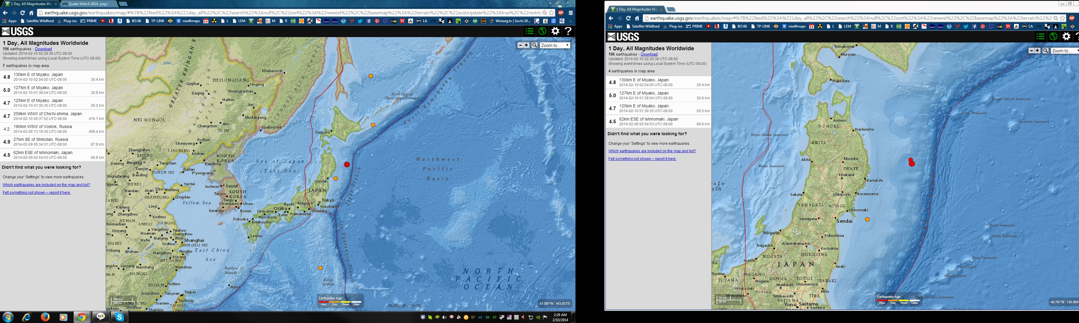
Something is up near Japan. Lots of activity...
M4.7 - 125km E of Miyako, Japan
2014-02-10 09:30:35 UTC
Event Time
2014-02-10 09:30:35 UTC
2014-02-10 19:30:35 UTC+10:00 at epicenter
2014-02-10 01:30:35 UTC-08:00 system time
Location
39.757°N 143.405°E depth=26.0km (16.2mi)
Nearby Cities
125km (78mi) E of Miyako, Japan
129km (80mi) ENE of Yamada, Japan
136km (85mi) ENE of Otsuchi, Japan
141km (88mi) ENE of Kamaishi, Japan
557km (346mi) NE of Tokyo, Japan
earthquake.usgs.gov...
M5.0 - 127km E of Miyako, Japan
2014-02-10 09:38:04 UTC
Event Time
2014-02-10 09:38:04 UTC
2014-02-10 19:38:04 UTC+10:00 at epicenter
2014-02-10 01:38:04 UTC-08:00 system time
Location
39.662°N 143.441°E depth=30.8km (19.2mi)
Nearby Cities
127km (79mi) E of Miyako, Japan
129km (80mi) E of Yamada, Japan
136km (85mi) ENE of Otsuchi, Japan
141km (88mi) ENE of Kamaishi, Japan
551km (342mi) NE of Tokyo, Japan
earthquake.usgs.gov...
M4.8 - 130km E of Miyako, Japan
2014-02-10 10:04:00 UTC
Event Time
2014-02-10 10:04:00 UTC
2014-02-10 20:04:00 UTC+10:00 at epicenter
2014-02-10 02:04:00 UTC-08:00 system time
Location
39.652°N 143.476°E depth=30.4km (18.9mi)
Nearby Cities
130km (81mi) E of Miyako, Japan
132km (82mi) E of Yamada, Japan
139km (86mi) ENE of Otsuchi, Japan
143km (89mi) ENE of Kamaishi, Japan
552km (343mi) NE of Tokyo, Japan
earthquake.usgs.gov...
files.abovetopsecret.com...
Another one dreamfox1, Mag 5.3 a bit deep, south of Tokyo. I don't
wanted to see a big one in this area.
reply to post by radpetey
Another small one:
It's only been 4 years since the most recent strong quake offshore Eureka, CA (Mag 6.5 on 10 Jan 2010), and almost 9 years since the last Mag 7+.
Could be something big coming, but who knows? The GPS in the area intrigues me--many of the stations are deviating from their trends in a manner similar to just prior to the mag 7.1 in 2005, but we don't have GPS records going back much further than that. So they could just be showing a longer cycle pattern, and aren't "forecasting" anything.
I wish I could live a few hundred years just to see how all of this plays out.
5.3
101km S of Tateyama, Japan
2014-02-10 19:14:39 UTC92.9 km
reply to post by radpetey
radpetey
Quite a few 3's and 4's in that junction area in the last couple of months!!
Just sayin'!
Another small one:
3.3
81km WSW of Ferndale, California
2014-02-10 19:09:54 UTC10.6 km
It's only been 4 years since the most recent strong quake offshore Eureka, CA (Mag 6.5 on 10 Jan 2010), and almost 9 years since the last Mag 7+.
Could be something big coming, but who knows? The GPS in the area intrigues me--many of the stations are deviating from their trends in a manner similar to just prior to the mag 7.1 in 2005, but we don't have GPS records going back much further than that. So they could just be showing a longer cycle pattern, and aren't "forecasting" anything.
I wish I could live a few hundred years just to see how all of this plays out.
edit on 2/10/2014 by Olivine because: add
reply
edit on 2/10/2014 by Olivine because: change another to a--otherwise it read like I had already lived hundreds of year--which I
haven't, although somedays it feels like it.
reply to post by dreamfox1
11 quakes in that FAR E OFF SANRIKU (Off East Coast Of Honshu. Japan) series, and that is only to half way through the 10th Jan UTC day.
Data is off JMA, rather than NIED who don't usually pick up the "far off the coast" quakes in the preliminary data.
interactive map of what I just said
JMA full days reviewed data for the 10th won't be available for another 6 hrs.
This reviewing time lag is a bit of a PITA, to keep a decent archive you virtually have to do the process twice, the networks have various time lags before the reviewed data comes out, I just did Kefalonia for the 9th, off NOA, and got about 20 odd events for the whole of Greece, so thought that was it, things had quietened down there.
But then I had another look 24 hrs later and they had 91 !!!
China's the same, takes about 24hrs. Maybe I should step back and wait 24 hrs or even wait till the end of the month.
Would be less work for archiving, but doesn't help with seeing trends in a relevant timely fashion
11 quakes in that FAR E OFF SANRIKU (Off East Coast Of Honshu. Japan) series, and that is only to half way through the 10th Jan UTC day.
Data is off JMA, rather than NIED who don't usually pick up the "far off the coast" quakes in the preliminary data.
interactive map of what I just said
JMA full days reviewed data for the 10th won't be available for another 6 hrs.
edit on 02000000414114 by muzzy because: (no reason given)
This reviewing time lag is a bit of a PITA, to keep a decent archive you virtually have to do the process twice, the networks have various time lags before the reviewed data comes out, I just did Kefalonia for the 9th, off NOA, and got about 20 odd events for the whole of Greece, so thought that was it, things had quietened down there.
But then I had another look 24 hrs later and they had 91 !!!
China's the same, takes about 24hrs. Maybe I should step back and wait 24 hrs or even wait till the end of the month.
Would be less work for archiving, but doesn't help with seeing trends in a relevant timely fashion
edit on 02u414114 by muzzy because: (no reason given)
What is going on in the Mammoth Lakes area?
317 quakes in the last 7 days, according to USGS. 55 just today.
Just wondering...
Oh here, I found some news
Long Valley caldera (California, USA): small earthquake swarm east of Mammoth Mountain
www.volcanodiscovery.com...
317 quakes in the last 7 days, according to USGS. 55 just today.
Just wondering...
Oh here, I found some news
Long Valley caldera (California, USA): small earthquake swarm east of Mammoth Mountain
www.volcanodiscovery.com...
An small earthquake swarm at shallow depths (around 5 km) occurred east of Mammoth Mountain during the past week. The largest quake was a magnitude 3.0 event on 5 Feb.
This latest (of many in the past years) seismic swarm is weak in terms of number and energy of earthquakes compared to long-term averages of seismic activity at the Long Valley caldera, an active volcanic system that is capable to erupt (probably not in a near future, though) and is being closely monitored by very experienced staff from USGS.
It could be related to a small intrusion of magma, but is unlikely to be a precursor of a new eruption in any near future. USGS has not changed the status code of the volcanic system (at green=normal).
Yellowstone...
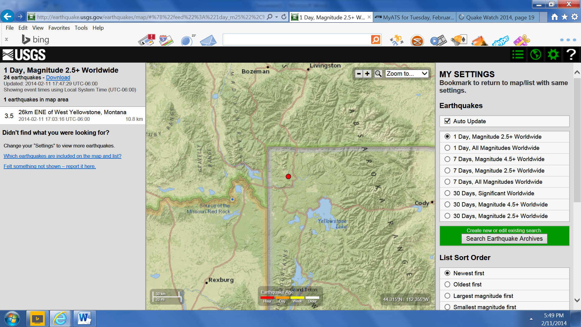
earthquake.usgs.gov... ain%22%2C%22autoUpdate%22%3Atrue%2C%22restrictListToMap%22%3Atrue%2C%22timeZone%22%3A%22local%22%2C%22mapposition%22%3A%5B%5B43.589661836532514%2C-112 .53103617578745%5D%2C%5B45.71895193975333%2C-109.01541117578745%5D%5D%2C%22overlays%22%3A%7B%22plates%22%3Atrue%7D%2C%22viewModes%22%3A%7B%22map%22%3A true%2C%22list%22%3Atrue%2C%22settings%22%3Atrue%2C%22help%22%3Afalse%7D%7D
earthquake.usgs.gov... ain%22%2C%22autoUpdate%22%3Atrue%2C%22restrictListToMap%22%3Atrue%2C%22timeZone%22%3A%22local%22%2C%22mapposition%22%3A%5B%5B43.589661836532514%2C-112 .53103617578745%5D%2C%5B45.71895193975333%2C-109.01541117578745%5D%5D%2C%22overlays%22%3A%7B%22plates%22%3Atrue%7D%2C%22viewModes%22%3A%7B%22map%22%3A true%2C%22list%22%3Atrue%2C%22settings%22%3Atrue%2C%22help%22%3Afalse%7D%7D
reply to post by berkeleygal
It can be seen on most of the surrounding stations as well.
Wasn't happy with Mammoth getting all the attention...

YPM
Mammoth is showing 64 EQs in the last 24 hours so far.
It can be seen on most of the surrounding stations as well.
Wasn't happy with Mammoth getting all the attention...
YPM
Mammoth is showing 64 EQs in the last 24 hours so far.
edit on 11-2-2014 by sageturkey because: Mammoth
edit on 11-2-2014 by sageturkey because: Link to YPM
China: 6.9
www.emsc-csem.org...
Location in Google Maps
Derived from Event Data Source: USGS
Powered by QVSData
Follow up to date information on Earthquake Report: Extremely dangerous earthquake along the Xinjiang – Tibet border in China
www.emsc-csem.org...
Magnitude 6.8 - Xizang (306)
Location in Google Maps
- Date-Time: Wednesday, February 12, 2014 @ 09:19:49 UTC
- Earthquake location: 35.922°N, 82.558°E,
- Earthquake depth: 12.5 km
- Distances:
269km (167mi) ESE of Hotan, China
493km (306mi) ENE of Leh, India
522km (324mi) SSE of Aral, China
547km (339mi) ESE of Shache, China
903km (561mi) ENE of Islamabad, Pakistan
- Event ID: usc000mnvj
Derived from Event Data Source: USGS
Powered by QVSData
edit on 12/2/2014 by PuterMan because: (no reason given)
Follow up to date information on Earthquake Report: Extremely dangerous earthquake along the Xinjiang – Tibet border in China
edit on 12/2/2014 by PuterMan because: (no reason given)
PuterMan
China: 6.8
www.emsc-csem.org...
you are always on top of it!! seen a large p wave coming into yellowstone... knew something was up... good job!!
guess that the weird bended lines on YNR / YMR are caused by the 5000 cubic km magma vibrating like an yelly pudding after the china tremor?
www.quake.utah.edu...
www.quake.utah.edu...
edit on 12-2-2014 by ressiv because: (no reason given)
reply to post by ressiv
I don't know if anyone else has noticed but all the Yellowstone recorders have had the location changed from -- to 01 so where it was for example YUF.WY..HHZ it is now YUF.WY.01.HHZ
The links in QVSData, if you use that, in the webicorder need to be deleted and re-added to your favourites.
I could not find a plot for Upper Falls which was what set me looking. Here is the 'jelly' (English) 'jello' (American) at YUF with the new location. YUF.WY.01.HHZ.2014.043_h800_w800
ETA looks as if the change was 9 days ago.
edit on 12/2/2014 by PuterMan because: (no reason given)
@Puters...how's the weather with you looking Puters?....shaking your house much yet? Thinking of you.
Rainbows
Jane
Rainbows
Jane
reply to post by berkeleygal
what you need is an interactive map of those;
(click image for interactive map,
opens in new tab/window)
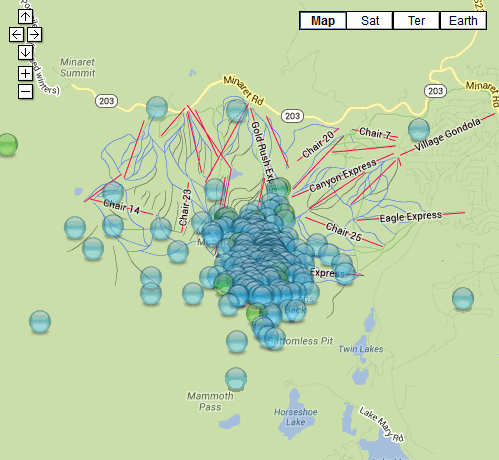
Thats made from USGS data 02-12 Feb (last 10 days), once in the interactive mode zoom out and you can get all the USGS for the whole Planet!
All this was on GSAIM USGS maps ............ I didn't notice it, as the swarm is quite confined geographically to Mammoth Mt.
Sure got enough ski-lifts there! LOL
what you need is an interactive map of those;
(click image for interactive map,
opens in new tab/window)
Thats made from USGS data 02-12 Feb (last 10 days), once in the interactive mode zoom out and you can get all the USGS for the whole Planet!
All this was on GSAIM USGS maps ............ I didn't notice it, as the swarm is quite confined geographically to Mammoth Mt.
Sure got enough ski-lifts there! LOL
M5.7
- Easter Island region
2014-02-14 07:44:15 UTC
earthquake.usgs.gov...
Event Time
2014-02-14 07:44:15 UTC
2014-02-13 23:44:15 UTC-08:00 at epicenter
2014-02-13 23:44:15 UTC-08:00 system time
Location
22.938°S 114.282°W depth=10.0km (6.2mi)
Nearby Cities
675km (419mi) NW of Hanga Roa, Chile
3718km (2310mi) ESE of Mahina, French Polynesia
3718km (2310mi) ESE of Papao, French Polynesia
3723km (2313mi) ESE of Pirae, French Polynesia
1625km (1010mi) E of Adamstown, Pitcairn
reply to post by dreamfox1
Deutsches GeoForschungsZentrum GFZ (Geofon) say;
map of recent events in the area (1/1/2013 - now )
finger points to event
(click image for interactive map, opens in new tab/window)
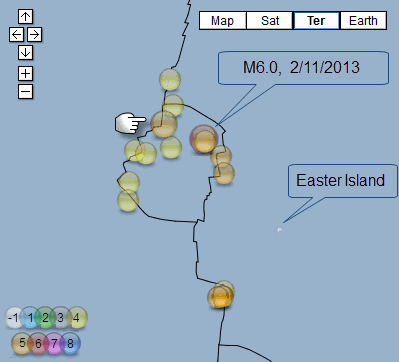
map of historic events in the area (8/04/2005 - now)
Largest magnitude on map M6.5 on 8/04/2005 (one of three M6's)
finger points to event
(click image for interactive map, opens in new tab/window)
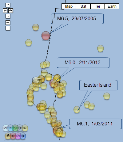
GFZ data. because I happened to have it open
Deutsches GeoForschungsZentrum GFZ (Geofon) say;
Date/Time: 14/02/2014 07:44:15
Lat: -22.97 Long: -114.42
Magnitude: M5.5 (5.4Mw)
Depth: 10 km
Location: Easter Island Region
map of recent events in the area (1/1/2013 - now )
finger points to event
(click image for interactive map, opens in new tab/window)
map of historic events in the area (8/04/2005 - now)
Largest magnitude on map M6.5 on 8/04/2005 (one of three M6's)
finger points to event
(click image for interactive map, opens in new tab/window)
GFZ data. because I happened to have it open
new topics
-
Any one suspicious of fever promotions events, card only.
The Gray Area: 3 minutes ago -
God's Righteousness is Greater than Our Wrath
Religion, Faith, And Theology: 4 hours ago -
Electrical tricks for saving money
Education and Media: 7 hours ago -
VP's Secret Service agent brawls with other agents at Andrews
Mainstream News: 8 hours ago -
Sunak spinning the sickness figures
Other Current Events: 9 hours ago -
Nearly 70% Of Americans Want Talks To End War In Ukraine
Political Issues: 9 hours ago -
Late Night with the Devil - a really good unusual modern horror film.
Movies: 11 hours ago
top topics
-
VP's Secret Service agent brawls with other agents at Andrews
Mainstream News: 8 hours ago, 9 flags -
Cats Used as Live Bait to Train Ferocious Pitbulls in Illegal NYC Dogfighting
Social Issues and Civil Unrest: 13 hours ago, 8 flags -
Electrical tricks for saving money
Education and Media: 7 hours ago, 4 flags -
HORRIBLE !! Russian Soldier Drinking Own Urine To Survive In Battle
World War Three: 17 hours ago, 3 flags -
Sunak spinning the sickness figures
Other Current Events: 9 hours ago, 3 flags -
Nearly 70% Of Americans Want Talks To End War In Ukraine
Political Issues: 9 hours ago, 3 flags -
Late Night with the Devil - a really good unusual modern horror film.
Movies: 11 hours ago, 2 flags -
The Good News According to Jesus - Episode 1
Religion, Faith, And Theology: 14 hours ago, 1 flags -
God's Righteousness is Greater than Our Wrath
Religion, Faith, And Theology: 4 hours ago, 0 flags -
Any one suspicious of fever promotions events, card only.
The Gray Area: 3 minutes ago, 0 flags
active topics
-
Any one suspicious of fever promotions events, card only.
The Gray Area • 0 • : Cavemannick -
SETI chief says US has no evidence for alien technology. 'And we never have'
Aliens and UFOs • 46 • : yuppa -
God's Righteousness is Greater than Our Wrath
Religion, Faith, And Theology • 1 • : andy06shake -
Sunak spinning the sickness figures
Other Current Events • 7 • : xWorldxGonexMadx -
HORRIBLE !! Russian Soldier Drinking Own Urine To Survive In Battle
World War Three • 33 • : Degradation33 -
How ageing is" immune deficiency"
Medical Issues & Conspiracies • 34 • : angelchemuel -
Nearly 70% Of Americans Want Talks To End War In Ukraine
Political Issues • 13 • : Freeborn -
Mood Music Part VI
Music • 3101 • : ThatSmellsStrange -
VP's Secret Service agent brawls with other agents at Andrews
Mainstream News • 41 • : ThatSmellsStrange -
New whistleblower Jason Sands speaks on Twitter Spaces last night.
Aliens and UFOs • 55 • : baablacksheep1